
The Central neighborhood of Minneapolis, Minnesota, United States is located south of the downtown region of the city. It is bounded by Lake Street on the north, Chicago Avenue on the east, 38th Street on the south, and Interstate 35W on the west. It should not be confused with the Central community, which covers Downtown and some surrounding neighborhoods.

Lowry Hill East, also known as the Wedge because of its wedge-like shape, is a neighborhood in southwest Minneapolis, Minnesota, United States, part of the Calhoun Isles community. Lowry Hill East developed in the 1880s along a horse-drawn streetcar line built by Thomas Lowry. The interior of the neighborhood is residential, with large early 20th century homes and multi-unit apartment buildings, while the border streets are lined with bars, restaurants, grocery stores, coffeeshops, and other small businesses. Most housing is renter-occupied.

The Diamond Lake neighborhood is in the Nokomis community in Minneapolis. It is bounded by Diamond Lake Road and 55th Street on the north, Cedar Avenue on the east, 62nd Street on the south, and Interstate 35W on the west. It has approximately 2233 households within its boundaries. The Diamond Lake neighborhood, together with Hale and Page, forms the HPDL.

Hiawatha is a neighborhood within the larger Longfellow community in Minneapolis. It is bordered by Howe to the north, the Mississippi River to the east, Minnehaha Park and Minnehaha neighborhood to the south, and Ericsson and Standish to the west. The Hiawatha neighborhood is bordered by 40th Street to the north, the Mississippi River to the east, 54th Street East to the south, and Hiawatha Avenue to the west.

Hale is a neighborhood near the southern edge of Minneapolis. It lies south of Minnehaha Creek, north of 55th Street, east of Chicago Avenue, and west of Cedar Avenue. The neighborhood takes its name from the local public school, Nathan Hale. Nathan Hale is a K-4 school. Most of the homes in the area were built in the 1920s and 30s. The regional parks forming the neighborhood's north and east borders give the neighborhood a recreational heart.

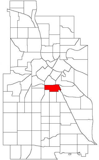
Bancroft is a neighborhood within the Powderhorn community in Minneapolis, Minnesota, United States. Its boundaries are East 38th Street to the north, Chicago Avenue to the west, East 42nd Street to the south and Cedar Avenue to the east. It is entirely located within Minneapolis City Council Ward 8, represented by Andrea Jenkins.
Nicollet Island/East Bank is a neighborhood in the University community of Minneapolis. It is a part of Minneapolis City Council Ward 3, represented by Michael Rainville.

Downtown West is an official neighborhood in Minneapolis, part of the larger Central community. It is the heart of downtown Minneapolis, containing the bulk of high-rise office buildings in the city, and is what comes to mind when most Minneapolitans think of "downtown".

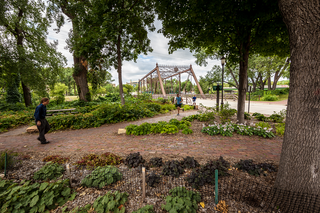
Downtown East is an official neighborhood in Minneapolis, Minnesota, United States. Within Downtown East is the Mill District, which contains former industrial buildings left over from the days when Minneapolis was the flour milling capital of the world. Many of these old mills and factories are being converted to housing, bringing a residential population to a neighborhood that beforehand didn't have many residents. Because of this, the Mill District in Downtown East is one of the fastest growing areas of the city.
Ventura Village is a neighborhood within the Phillips community in Minneapolis. Its boundaries are Interstate 35W to the west, Interstate 94 to the north, and Hiawatha Avenue to the east. The southern boundary runs along East 22nd Street from I-35W to Chicago Avenue, along East 24th Street from Chicago Avenue to 17th Avenue South, and then back up to 22nd Street from 17th Avenue to Hiawatha Avenue. Franklin Avenue, which runs east–west, acts as the main commercial artery in the neighborhood.

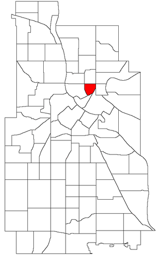
Marcy-Holmes is a neighborhood in the University community of Minneapolis. The majority of the area is residential and sits upon a bluff overlooking the river and the city skyline. A small section of the neighborhood along the river is an industrial zone.

Lyndale is a neighborhood within the Powderhorn community in south Minneapolis, Minnesota, United States. Its boundaries are Lake Street to the north, Interstate 35W to the east, 36th Street to the south and Lyndale Avenue South to the west.
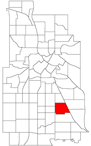
Standish is a neighborhood within the Powderhorn community in Minneapolis, Minnesota, United States named after Captain Miles Standish. Its boundaries are East 36th Street to the north, Hiawatha Avenue to the east, East 42nd and 43rd Streets to the south, and Cedar Avenue to the west.

Ericsson is a neighborhood within the Nokomis community in Minneapolis. Its boundaries are East 42nd and 43rd Streets to the north, Hiawatha Avenue to the east, Minnehaha Parkway to the south, and Cedar Avenue to the west. The neighborhood is the site of Lake Hiawatha, which is connected to Minnehaha Creek. Ericsson shares a neighborhood organization with Standish, even though that neighborhood lies in the Powderhorn community; signs at the western, southern, and eastern boundaries of the neighborhood welcome you to "Standish-Ericsson".

Fulton is a neighborhood in the Southwest community in Minneapolis. Its boundaries are West 47th Street to the north, Penn Avenue South to the east, West 54th Street to the south, and France Avenue South to the west. Fulton is a part of Ward 13, currently represented by Minneapolis City Council member Linea Palmisano.

Saint Anthony West is a neighborhood in the Northeast community of Minneapolis.

Regina is a neighborhood within the Nokomis community in Minneapolis, Minnesota. Its boundaries are 42nd Street to the north, Chicago Avenue to the east, 46th Street to the south, and Interstate 35W to the west. It shares a neighborhood organization with the Field and Northrop neighborhoods.

Morris Park is a neighborhood in the Nokomis community in Minneapolis, Minnesota. Its boundaries are 54th Street to the north, 46th Avenue to the east, the Twin Cities Air Force Base to the south, and 34th Avenue to the west. It shares a neighborhood organization with the Keewaydin, Minnehaha, and Wenonah neighborhoods, which are collectively referred to as Nokomis East and served by the Nokomis East Neighborhood Association (NENA).
St. Anthony East is a neighborhood of the Northeast community in Minneapolis.

Corcoran is a neighborhood within the Powderhorn community in Minneapolis, Minnesota, United States. The neighborhood is bordered by Longfellow and Howe neighborhoods to the east, Phillips to the north, Powderhorn Park to the west and Standish to the south. Its official boundaries are East Lake Street to the north, Hiawatha Avenue to the east, East 36th Street to the south, and Cedar Avenue to the west. It is entirely located within Minneapolis City Council Ward 9, represented by Jason Chavez.

