
Holland is a neighborhood in the Northeast community in Minneapolis. It is one of ten neighborhoods in Ward 1 of Minneapolis, currently represented by Council President Elliott Payne.
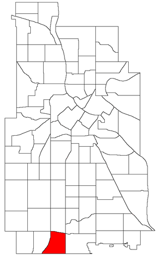
The Windom neighborhood is located in the Southwest community of Minneapolis. Its borders are Diamond Lake Road and West 54th Street to the north, Interstate 35W to the east, West 62nd Street to the south, and Lyndale Avenue South and Highway 121 to the west. Windom is a part of Ward 11, currently represented by Minneapolis City Council member Emily Koski.
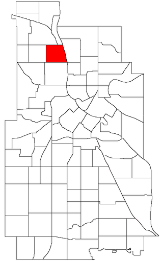
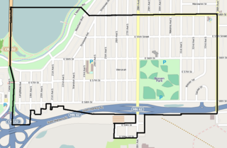
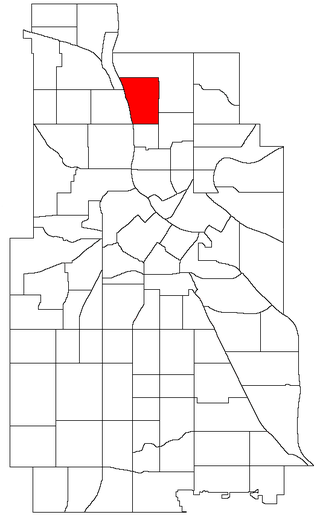
The Audubon Park neighborhood is located in the Northeast community in Minneapolis. Audubon Park is one of ten neighborhoods in Ward 1 of Minneapolis, currently represented by Council President Elliott Payne. The neighborhood is bounded by Saint Anthony Parkway to the north, NE Stinson Parkway to the east, NE Lowry Avenue to the south, and Central Avenue to the west. Stinson Parkway and St. Anthony Parkway are both part of the Grand Rounds National Scenic Byway. Stinson Parkway is also the city's border with St. Anthony.
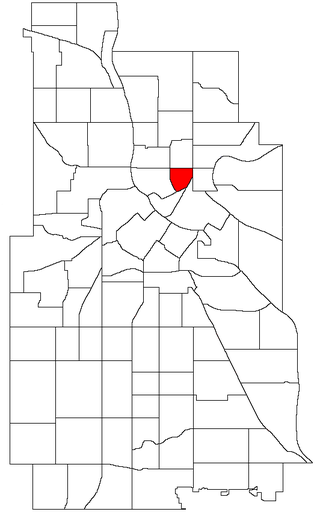
Nicollet Island/East Bank is a neighborhood in the University community of Minneapolis. It is a part of Minneapolis City Council Ward 3, represented by Michael Rainville.

Downtown West is an official neighborhood in Minneapolis, part of the larger Central community. It is the heart of downtown Minneapolis, containing the bulk of high-rise office buildings in the city, and is what comes to mind when most Minneapolitans think of "downtown". The neighborhood is split between Wards 3 and 7 of the Minneapolis City Council, represented by Michael Rainville and Katie Cashman, respectively.

Downtown East is an official neighborhood in Minneapolis, Minnesota, United States. It is in Ward 3, currently represented by council member Michael Rainville.
Folwell is a neighborhood in the U.S. city of Minneapolis on its northside that is bound by Dowling Avenue to the north, Dupont Avenue North to the east, Lowry Avenue North to the south, and Penn Avenue North to the west. It is part of the larger Camden community. It is located in Ward 4, represented by council member LaTrisha Vetaw.

Bottineau is a neighborhood in the Northeast community of Minneapolis. It is one of ten neighborhoods in Ward 1 of Minneapolis, currently represented by Council President Elliott Payne.

Columbia Park is a neighborhood in the Northeast community in Minneapolis. Its boundaries are 37th Avenue NE to the north, Central Avenue to the east, 27th Avenue NE to the south, and both University Avenue & Saint Anthony Parkway streets to the west. It is one of ten neighborhoods in Ward 1 of Minneapolis, currently represented by Council President Elliott Payne.

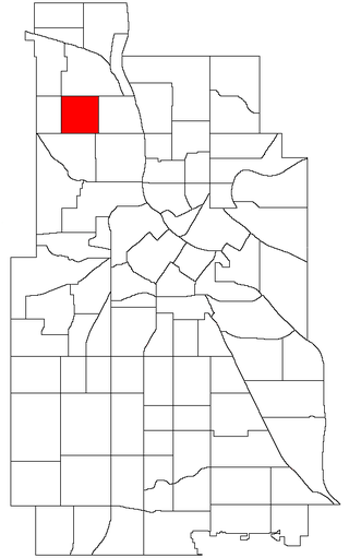
Jordan is a neighborhood in the Near North community in Minneapolis. Its boundaries are Lowry Avenue North to the north, Emerson Avenue North to the east, and West Broadway to the south and west.
McKinley is a neighborhood in the Camden community of Minneapolis. It is bound to the north by Dowling Avenue North, to the south by Lowry Avenue North, to the west by Dupont Avenue North, and to the east by the Mississippi River. It is part of the larger and located in Ward 4, represented by council member LaTrisha Vetaw.

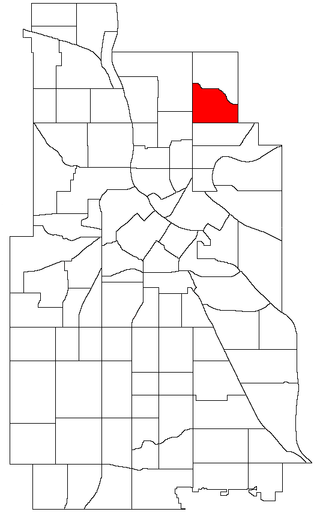
Waite Park is a neighborhood in the Northeast community in Minneapolis, Minnesota. Its boundaries are 37th Avenue NE to the north, NE Stinson Boulevard to the East, Saint Anthony Parkway to the south, and NE Central Avenue to the west. It is the furthest northeast neighborhood within Minneapolis. It is one of ten neighborhoods in Ward 1 of Minneapolis, currently represented by Council President Elliott Payne, and falls under the jurisdiction of the second precinct of the Minneapolis Police Department.

Keewaydin is a neighborhood in the Nokomis community in Minneapolis, Minnesota. Its boundaries are Minnehaha Parkway to the north, 34th Avenue to the east, 54th Street to the south, and Cedar Avenue to the west.

Morris Park is a neighborhood in the Nokomis community in Minneapolis, Minnesota. Its boundaries are 54th Street to the north, 46th Avenue to the east, the Twin Cities Air Force Base to the south, and 34th Avenue to the west. It is located in Ward 12 of the Minneapolis City Council, currently represented by council member Aurin Chowdhury.
Wenonah is a neighborhood on the southeast side of Minneapolis, Minnesota. Its boundaries are 54th Street to the north, 34th Avenue to the east, the Minneapolis-Saint Paul International Airport to the south, and Cedar Avenue to the west. The neighborhood contains a portion of Lake Nokomis.

Logan Park is a neighborhood in the Northeast community in Minneapolis. It is one of ten neighborhoods in Ward 1 of Minneapolis, currently represented by Council President Elliott Payne.
Marshall Terrace is a neighborhood in the Northeast community in Minneapolis. It is one of ten neighborhoods in Ward 1 of Minneapolis, currently represented by Council President Elliott Payne.

Northeast Park is a neighborhood in the Northeast community in Minneapolis, Minnesota. Its boundaries are 18th Avenue NE and New Brighton Boulevard to the north, the city limits to the northeast, Interstate 35W to the southeast, Broadway Street NE to the south, and Central Avenue to the west. It is one of ten neighborhoods in Ward 1 of Minneapolis, currently represented by Council President Elliott Payne.

Sheridan is a neighborhood in the Northeast community of Minneapolis.
St. Anthony East is a neighborhood of the Northeast community in Minneapolis. It is located in Ward 3, currently represented by council member Michael Rainville.
