City of St. Anthony Saint Anthony Village | |
---|---|
Nickname: The Village [1] | |
Motto: "A Village Within the City" [1] | |
Coordinates: 45°01′40″N93°13′03″W / 45.02778°N 93.21750°W | |
Country | United States |
State | Minnesota |
County | Hennepin, Ramsey |
Established (township) | 1861 |
Incorporated (village) | 1945 |
Incorporated (city) | 1974 |
Government | |
• Mayor | Wendy Webster |
Area | |
• Total | 2.35 sq mi (6.10 km2) |
• Land | 2.24 sq mi (5.79 km2) |
• Water | 0.12 sq mi (0.30 km2) |
Elevation | 997 ft (304 m) |
Population | |
• Total | 9,257 |
• Estimate (2022) [5] | 10,124 |
• Density | 4,139.98/sq mi (1,598.58/km2) |
Time zone | UTC-6 (Central) |
• Summer (DST) | UTC-5 (CDT) |
ZIP codes | 55418, 55421 |
Area code(s) | 612, 651 |
FIPS code | 27-56680 |
GNIS feature ID | 2396471 [3] |
Website | savmn.com |
St. Anthony, also known as Saint Anthony Village, is a city in Hennepin and Ramsey counties in the U.S. state of Minnesota. The population was 9,257 at the 2020 census, [4] of whom 5,621 lived in the larger Hennepin County part of the city and 3,654 in the Ramsey County part. The city is run by a five-member council consisting of a mayor and four council members who serve four-year terms.
St. Anthony's origins date to 1838, when Franklin Steele, a storekeeper at Fort Snelling, made a claim on the land east of St. Anthony Falls. Steele did not begin developing the land until 1848, but it quickly became a center of milling and trade much like the neighboring town of Minneapolis on the land west of the falls. In 1858 the town was formally organized as the Township of St. Anthony. [6]
In 1872, Minneapolis annexed most of St. Anthony (much of present-day Northeast Minneapolis). Roughly 1,000 acres (400 ha) of mostly agricultural land north of the city retained the name St. Anthony but remained unincorporated. In 1945, the township's residents voted 167–57 in favor of incorporating as a village. The state challenged this decision on the basis that St. Anthony was too agricultural and rural, but it was upheld by the Minnesota Supreme Court. As the city's suburbs grew outward, St. Anthony evolved from a rural township to an inner suburb. [7]
St. Anthony was the home of Apache Plaza, the tenth indoor shopping mall in United States, which opened in October 1961. The oldest, Southdale, lay only 15 miles (24 km) to the south and was completed in October 1956. Built in the 1950s, the St. Anthony Shopping Center was Minnesota's first strip mall and was owned by the Batista family of Cuba. [8]
In the spring of 2006, the St. Anthony Village High School Huskies claimed ISD 282's first state baseball championship. The Huskies won the championship again in 2008. The school has also won five Class AA state championships in Knowledge Bowl and has won one Minnesota Science Bowl competition.[ citation needed ]
St. Anthony is 4 miles (6 km) northeast of downtown Minneapolis. According to the United States Census Bureau, the city has a total area of 2.37 square miles (6.14 km2), of which 2.25 square miles (5.83 km2) is land and 0.12 square miles (0.31 km2) is water. [9]
One of St. Anthony's longest and most widely used streets is Silver Lake Road. Named for Silver Lake in the northwest part of the city, it runs the length of St. Anthony from north to south. County Highway 88 is another of the city's main routes. Interstate 35W skims through the south near the St. Anthony Boulevard exit.[ citation needed ]
Census | Pop. | Note | %± |
---|---|---|---|
1850 | 656 | — | |
1860 | 265 | −59.6% | |
1870 | 236 | −10.9% | |
1880 | 485 | 105.5% | |
1890 | 92 | −81.0% | |
1900 | 93 | 1.1% | |
1910 | 100 | 7.5% | |
1920 | 134 | 34.0% | |
1930 | 455 | 239.6% | |
1940 | 607 | 33.4% | |
1950 | 1,406 | 131.6% | |
1960 | 5,084 | 261.6% | |
1970 | 9,239 | 81.7% | |
1980 | 7,981 | −13.6% | |
1990 | 7,727 | −3.2% | |
2000 | 8,012 | 3.7% | |
2010 | 8,226 | 2.7% | |
2020 | 9,257 | 12.5% | |
2022 (est.) | 10,124 | [5] | 9.4% |
U.S. Decennial Census [10] 2020 Census [4] |
As of the census of 2010, there were 8,226 people, 3,848 households, and 2,054 families residing in the city. The population density was 3,656.0 inhabitants per square mile (1,411.6/km2). There were 4,098 housing units at an average density of 1,821.3 per square mile (703.2/km2). The racial makeup of the city was
1.0% from other races, and 2.3% from two or more races.
There were 3,848 households, of which 21.5% had children under the age of 18 living with them, 42.5% were married couples living together, 7.7% had a female householder with no husband present, 3.2% had a male householder with no wife present, and 46.6% were non-families. 39.3% of all households were made up of individuals, and 19.2% had someone living alone who was 65 years of age or older. The average household size was 2.11 and the average family size was 2.83.
The median age in the city was 43.1 years. 17.5% of residents were under the age of 18; 8.5% were between the ages of 18 and 24; 26.1% were from 25 to 44; 26.4% were from 45 to 64; and 21.4% were 65 years of age or older. The gender makeup of the city was 46.1% male and 53.9% female.
As of the census of 2000, there were 8,012 people, 3,697 households, and 2,007 families residing in the city. The population density was 3,513.8 inhabitants per square mile (1,356.7/km2). There were 3,812 housing units at an average density of 1,671.8 per square mile (645.5/km2). The racial makeup of the city was 90.58% White, 2.06% African American, 0.64% Native American, 4.51% Asian, 0.02% Pacific Islander, 0.79% from other races, and 1.41% from two or more races. Hispanic or Latino of any race were 1.65% of the population. 20.5% were of German, 12.6% Norwegian, 10.5% Swedish, 8.7% Polish and 6.3% Irish ancestry.
There were 3,697 households, out of which 20.0% had children under the age of 18 living with them, 44.7% were married couples living together, 7.0% had a female householder with no husband present, and 45.7% were non-families. 38.2% of all households were made up of individuals, and 18.5% had someone living alone who was 65 years of age or older. The average household size was 2.11 and the average family size was 2.83.
In the city, the population was spread out, with 18.0% under the age of 18, 8.9% from 18 to 24, 26.2% from 25 to 44, 21.9% from 45 to 64, and 25.1% who were 65 years of age or older. The median age was 43 years. For every 100 females, there were 85.2 males. For every 100 females age 18 and over, there were 79.5 males.
The median income for a household in the city was $46,883, and the median income for a family was $62,500. Males had a median income of $43,043 versus $31,304 for females. The per capita income for the city was $26,290. About 2.8% of families and 5.1% of the population were below the poverty line, including 5.0% of those under age 18 and 3.0% of those age 65 or over.
St. Anthony is served by the St. Anthony-New Brighton School District, ISD 282. Wilshire Park Elementary School is the district's primary school. St. Anthony Middle School serves grades 6–8. St. Anthony Village High School serves grades 9–12. St. Charles Borromeo offers private education for grades K–8.
St. Anthony has several city parks. The most notable is Central Park, in the center of the city near the High School and Community Center, as well as the police station, fire station and water treatment plant. Several of the high school's athletic teams host home competitions in Central Park. Smaller parks include Emerald Park, Silver Point Park, and Trillium Park. St. Anthony also has a golf course maintained by the Minneapolis Parks and Recreation Board and a county park, Silverwood, maintained by the Three Rivers Park District. [11] [12] Silverwood Park is on Silver Lake, which is almost entirely within St. Anthony's boundaries.
St. Anthony Village has one sister city, as designated by Sister Cities International:
St. Anthony dedicated Salo Park to its sister city on June 8, 2006, in its Silver Lake Village development.
Columbia Heights is a city in Anoka County, Minnesota, United States. The population was 21,973 at the 2020 census.
Rice is a city in Benton County, Minnesota, United States. The population was 1,275 at the 2010 census. Its zip code also encompasses Graham, Langola, and Watab townships.
Rush City is a city in Chisago County, Minnesota, United States. The population was 3,079 at the 2010 census. It is fifty-eight miles north of Minneapolis–Saint Paul.
Zumbrota is a city in Goodhue County, Minnesota, United States, along the North Fork of the Zumbro River. The population was 3,252 at the 2010 census. It promotes itself as "the only Zumbrota in the world."
Hopkins is a suburban city in Hennepin County, Minnesota, United States, located west of Minneapolis. The population was 19,079 at the 2020 census. The city is four square miles in size and is surrounded by the larger suburban communities of Minnetonka, Saint Louis Park, and Edina. The city's main street was added to the National Register of Historic Places in 2022.
Ivanhoe is a city in Lincoln County, Minnesota, United States. The population was 559 at the 2010 census. Since 1902 it has been the county seat of Lincoln County and is now the least populous county seat in Minnesota.
Northrop is a city in Martin County, Minnesota, United States. The population was 223 at the 2020 census.
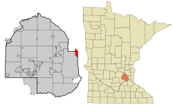
Lauderdale is a city in Ramsey County, Minnesota, United States. The population was 2,379 at the 2010 census. Lauderdale is part of the Minneapolis–St. Paul metropolitan area and is surrounded by Minneapolis, St. Paul, Roseville, and Falcon Heights. Along with Roseville, it is one of two cities to touch both Minneapolis and St Paul.
New Brighton is a city in Ramsey County, Minnesota, United States. It is a suburb of the Twin Cities. The population was 23,454 at the 2020 census.
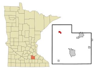
Lonsdale is a city in Rice County, Minnesota, United States. The population was 4,686 at the 2020 census, with a 2024 estimate of 5,112. A fast growing exurb of the Minneapolis-Saint Paul metropolitan area, Lonsdale is located 40 miles south of downtown Minneapolis.
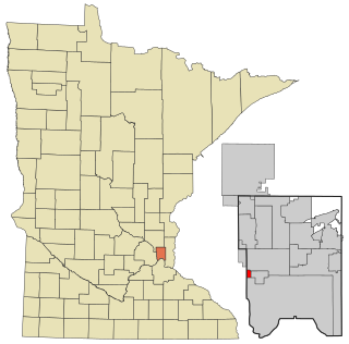
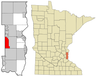
Gaylord is a city and the county seat of Sibley County, Minnesota, United States, along the shore of Titlow Lake. It is approximately 65 miles (105 km) west-southwest of Minneapolis-St. Paul. The population was 2,305 at the 2010 census.
Waite Park is a city in Stearns County, Minnesota, United States. The population was 8,341 at the 2020 census.
Kerkhoven is a city in Swift County, Minnesota, United States, located roughly 100 miles (160 km) west of the Twin Cities region of Minneapolis/St. Paul along U.S. Route 12. The population was 759 as per the 2010 census.
Oakdale is a city in Washington County, Minnesota, United States. It is a suburb of Saint Paul and is on the eastern side of the Twin Cities Metropolitan area. The population was 28,303 at the 2020 census. Oakdale is the 36th largest city in Minnesota by population.
Stockton is a city in Winona County, Minnesota, United States. The population was 809 at the 2020 census.
Albertville is a city in Wright County, Minnesota, United States. The City is a Northwest suburb of the Minneapolis- St Paul “Twin Cities” metropolitan area. The population was 7,896 at the 2020 census.
Delano is a city in Wright County, Minnesota, United States. The population was 6,484 at the 2020 census. The city prides itself on its "small-town feel." It is on the outskirts of the Twin Cities Metropolitan Statistical Area.
Otsego is a city in Wright County, Minnesota, United States. It is a northwest suburb within the Minneapolis–Saint Paul metropolitan area. The population was 19,966 at the 2020 census. Otsego is the largest city in Wright County, and the 48th largest city in Minnesota. Minnesota State Highway 101 and Interstate 94 serve as the main routes in the city.
Cobden is a city in Brown County, Minnesota, United States. The population was 36 at the 2010 census.
St. Croix Falls is a city in Polk County, Wisconsin, United States. The population was 2,208 at the 2020 census. The city is located within the Town of St. Croix Falls.