Shorewood, Minnesota

Last updated
Shorewood
ShorewoodHennepin.PNG
Location of Shorewood
within Hennepin County, Minnesota
Country United States
State Minnesota
County Hennepin
Area
[1]
  Total8.15 sq mi (21.12 km2)
  Land5.31 sq mi (13.75 km2)
  Water2.84 sq mi (7.37 km2)
Population
 (2020)
  Total7,783
  Density1,465.73/sq mi (565.91/km2)
Time zone UTC-6 (Central (CST))
  Summer (DST) UTC-5 (CDT)
FIPS code 27-60016
Website www.ci.shorewood.mn.us

Shorewood is a city nestled in the woods along on the shores of Lake Minnetonka in Hennepin County, Minnesota, United States. The population was 7,307 at the 2010 census. [2] The city was incorporated in 1956. Its area was originally part of the former Excelsior Township.

Contents

State Highway 7 serves as a main route.

Geography

According to the United States Census Bureau, the city has a total area of 13.33 square miles (34.52 km2), of which 5.34 square miles (13.83 km2) is land and 7.99 square miles (20.69 km2) is water. [3] It includes the Lake Minnetonka islands of Spray, Shady, and part of Enchanted. These islands are more accessible from the nearby city of Mound that provides them with postal services, fire protection, and schools.

Demographics

Historical population
CensusPop.
1860 317
1870 3355.7%
1880 51353.1%
1890 468−8.8%
1900 68145.5%
1910 89831.9%
1920 9445.1%
1930 925−2.0%
1940 1,47559.5%
1950 2,46767.3%
1960 3,19729.6%
1970 4,22332.1%
1980 4,64610.0%
1990 5,91727.4%
2000 7,40025.1%
2010 7,307−1.3%
2020 7,7796.5%
U.S. Decennial Census

2010 census

As of the census [4] of 2010, there were 7,307 people, 2,658 households, and 2,131 families living in the city. The population density was 1,368.4 inhabitants per square mile (528.3/km2). There were 2,812 housing units at an average density of 526.6 per square mile (203.3/km2). The racial makeup of the city was 95.8% White, 0.8% African American, 0.3% Native American, 1.4% Asian, 0.1% Pacific Islander, 0.3% from other races, and 1.4% from two or more races. Hispanic or Latino of any race were 1.7% of the population.

There were 2,658 households, of which 38.1% had children under the age of 18 living with them, 71.1% were married couples living together, 6.3% had a female householder with no husband present, 2.7% had a male householder with no wife present, and 19.8% were non-families. 16.5% of all households were made up of individuals, and 7.2% had someone living alone who was 65 years of age or older. The average household size was 2.75 and the average family size was 3.10.

The median age in the city was 45.3 years. 27.1% of residents were under the age of 18; 5.6% were between the ages of 18 and 24; 16.7% were from 25 to 44; 38.1% were from 45 to 64; and 12.5% were 65 years of age or older. The gender makeup of the city was 49.5% male and 50.5% female.

2000 census

As of the census [5] of 2000, there were 7,400 people, 2,529 households, and 2,106 families living in the city. The population density was 1,393.5 inhabitants per square mile (538.0/km2). There were 2,599 housing units at an average density of 489.4 per square mile (189.0/km2). The racial makeup of the city was 97.82% White, 0.39% African American, 0.03% Native American, or Indian, 0.89% Asian, 0.19% from other races, and 0.68% from two or more races. Hispanic or Latino of any race were 0.82% of the population.

There were 2,529 households, out of which 45.3% had children under the age of 18 living with them, 75.7% were married couples living together, 4.9% had a female householder with no husband present, and 16.7% were non-families. 13.2% of all households were made up of individuals, and 3.9% had someone living alone who was 65 years of age or older. The average household size was 2.93 and the average family size was 3.22.

In the city, the population was spread out, with 31.6% under the age of 18, 4.5% from 18 to 24, 28.3% from 25 to 44, 27.6% from 45 to 64, and 7.9% who were 65 years of age or older. The median age was 39 years. For every 100 females, there were 100.2 males. For every 100 females age 18 and over, there were 100.6 males.

The median income for a household in the city was $96,589, and the median income for a family was $104,100. Males had a median income of $68,182 versus $41,679 for females. The per capita income for the city was $44,425. About 1.3% of families and 1.7% of the population were below the poverty line, including 1.0% of those under age 18 and 3.0% of those age 65 or over.

Politics

Presidential election results 1960–2020
Precinct General Election Results [6]
Year Republican Democratic Third parties
2020 41.9% 2,35856.4%3,1771.7% 100
2016 43.6% 2,15946.7%2,3149.7% 480
2012 56.3%2,81042.3% 2,1091.4% 70
2008 51.8%2,56546.8% 2,3141.4% 71
2004 57.1%2,74941.8% 2,0161.1% 53
2000 56.0%2,52637.7% 1,7026.3% 286
1996 51.0%1,99838.8% 1,52210.2% 401
1992 41.2%1,64130.1% 1,19828.7% 1,144
1988 61.2%1,89038.8% 1,1980.0% 0
1984 61.9%1,61938.1% 9950.0% 0
1980 50.8%1.35535.2% 93914.0% 372
1976 55.7%1,31741.3% 9773.0% 71
1972 61.5%1,12536.2% 6632.3% 42
1968 54.4%92843.1% 7352.5% 42
1964 51.1%80948.8% 7720.1% 2
1960 65.6%95234.3% 4980.1% 1

Education

The city of Shorewood is part of the Minnetonka Public School District. Minnewashta Elementary School is located within the city limits and is the largest elementary school in the Minnetonka District.

Related Research Articles

<span class="mw-page-title-main">Paulden, Arizona</span> CDP in Yavapai County, Arizona

Paulden is a census designated place (CDP) in Yavapai County, Arizona, United States. The population was 5,231 at the 2010 census.

<span class="mw-page-title-main">Troy, Illinois</span> City in Illinois, United States

For the village in Will County, see Shorewood, Illinois.

<span class="mw-page-title-main">Shorewood, Illinois</span> Village in Illinois, United States

Shorewood is a village in Troy Township, Will County, Illinois, United States. The population was 7,686 at the 2000 census, and estimated to be 15,615 as of 2010.

<span class="mw-page-title-main">Port Austin Township, Michigan</span> Civil township in Michigan, United States

Port Austin Township is a civil township of Huron County in the U.S. state of Michigan. The population was 1,591 at the 2000 census.

<span class="mw-page-title-main">Deephaven, Minnesota</span> Incorporated community in Minnesota, United States

Deephaven is a small city in Hennepin County, Minnesota, United States. The community is located on Lake Minnetonka. The community’s center is the historic Cottagewood General Store, which has been serving the Lake Minnetonka area since 1895. It is located 14 miles (23 km) west-southwest of downtown Minneapolis. The population was 3,642 as of the 2010 Census, down from 3,853 as of the 2000 census.

<span class="mw-page-title-main">Excelsior, Minnesota</span> Lakeside city in Minnesota, United States

Excelsior is a city in Hennepin County, Minnesota, United States. Excelsior's historic commercial district along Water Street is listed on the National Register of Historic Places, and the town has many Victorian-era houses. On Lake Minnetonka's southern shore, the community serves as a local tourism destination for shoppers, boaters, and restaurant-goers.

<span class="mw-page-title-main">Minnetonka, Minnesota</span> City in Minnesota, United States

Minnetonka is a city in Hennepin County, Minnesota, United States. A western suburb of the Twin Cities, Minnetonka is located about 10 miles (16 km) west of downtown Minneapolis. At the 2020 census, the city's population was 53,781.

<span class="mw-page-title-main">Minnetonka Beach, Minnesota</span> City in Minnesota, United States

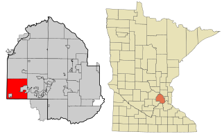
Minnetonka Beach is a community in Hennepin County, Minnesota, United States. The population was 539 at the 2010 census.

<span class="mw-page-title-main">Minnetrista, Minnesota</span> City in Minnesota, United States

Minnetrista is a city in Hennepin County, Minnesota, United States. Largely rural, Minnetrista has agricultural activity involving corn, soybeans, hay and horses. In addition to farmland and woods, the city is home to several lakes, including part of Lake Minnetonka, the state's ninth-biggest.

<span class="mw-page-title-main">Mound, Minnesota</span> City in Minnesota, United States

Mound is a city in western Hennepin County, Minnesota, United States. The population was 9,052 at the 2010 census. Mound was the birthplace of the Tonka truck that is named after Lake Minnetonka, which the eastern part of town sits on. Mound is 22 miles (35 km) west of Minneapolis, the county seat.

<span class="mw-page-title-main">Tonka Bay, Minnesota</span> City in Minnesota, United States

Tonka Bay is a city in Hennepin County, Minnesota, United States. It is located on Lake Minnetonka between the upper and lower lakes. It gained some popularity in the 1880s and 1890s as a summer lake resort. The population of Tonka Bay was 1,475 at the 2010 census.

<span class="mw-page-title-main">Woodland, Minnesota</span> City in Minnesota, United States

Woodland is a community in Hennepin County, Minnesota, United States, with lake shore property on Lake Minnetonka. The population was 437 at the 2010 census. The first settlers arrived in 1857, when Woodland was part of Minnetonka Township. The land was formally platted in 1882 and developed through the 1890s. Woodland was incorporated as the independent village of Maplewoods in December 1948. It was renamed "Woodland" in 1949.

<span class="mw-page-title-main">Spring Park, Minnesota</span> City in Minnesota, United States

Spring Park is a small city nestled on the shores of Lake Minnetonka in Hennepin County, Minnesota, United States and is about 20 miles west of Minneapolis. The population was 1,669 at the 2010 census.

<span class="mw-page-title-main">Gloria Glens Park, Ohio</span> Village in Ohio, United States

Gloria Glens Park is a village in Medina County, Ohio, United States. The population was 425 at the 2010 census.

<span class="mw-page-title-main">Coal Center, Pennsylvania</span> Borough in Pennsylvania, United States

Coal Center is a borough on the Monongahela River in Washington County, Pennsylvania and part of the Pittsburgh metropolitan area since 1950. The population was 110 at the 2020 census.

<span class="mw-page-title-main">Shorewood Hills, Wisconsin</span> Village in Wisconsin, United States

Shorewood Hills is a village in Dane County, Wisconsin, United States. It was established in 1927. The population was 2,169 at the 2020 census. Entirely surrounded by the city of Madison and Lake Mendota, it is part of the Madison Metropolitan Statistical Area.

<span class="mw-page-title-main">Livingston, Wisconsin</span> Village in Wisconsin, United States

Livingston is a village in Grant and Iowa Counties in the U.S. state of Wisconsin. The population was 664 at the 2010 census. Of this, 657 were in Grant County, and only 7 were in Iowa County.

Burke is a village in Franklin County, New York, United States. The population was 211 at the 2010 census. The village is in the town of Burke and is northeast of Malone, the county seat.

<span class="mw-page-title-main">Green Bay (town), Wisconsin</span> Human settlement in Wisconsin, United States of America

Green Bay is a town in Brown County in the U.S. state of Wisconsin. The population was 2,035 at the 2010 census. The town is located several miles northeast of the city of Green Bay. The unincorporated community of Champion is located in the town, and the unincorporated communities of Dyckesville and New Franken are located partially in the town.

Oakfield is a town in Fond du Lac County, Wisconsin, United States. The population was 767 at the 2000 census. The Village of Oakfield is located within the town. The unincorporated community of Oak Center is also located in the town.

References

  1. "2020 U.S. Gazetteer Files". United States Census Bureau. Retrieved July 24, 2022.
  2. "2010 Census Redistricting Data (Public Law 94-171) Summary File". American FactFinder. U.S. Census Bureau, 2010 Census. Retrieved 23 April 2011.[ dead link ]
  3. "US Gazetteer files 2010". United States Census Bureau. Archived from the original on January 12, 2012. Retrieved 2012-11-13.
  4. "U.S. Census website". United States Census Bureau . Retrieved 2012-11-13.
  5. "U.S. Census website". United States Census Bureau . Retrieved 2008-01-31.
  6. "Office of the Minnesota Secretary of State - Election Results". Archived from the original on February 22, 2021. Retrieved February 22, 2021.

Coordinates: 44°54′03″N93°35′21″W / 44.90083°N 93.58917°W / 44.90083; -93.58917