Hopkins, Minnesota

Last updated

Hopkins
Hopkins MN Mainstreet.jpg
Downtown Hopkins
HopkinsLogo.jpg
Hennepin County Minnesota Incorporated and Unincorporated areas Hopkins Highlighted.svg
Location of Hopkins
within Hennepin County, Minnesota
Coordinates: 44°55′50.77″N93°24′6.09″W / 44.9307694°N 93.4016917°W / 44.9307694; -93.4016917
CountryUnited States
State Minnesota
County Hennepin
Founded1852
IncorporatedNovember 27, 1892 (as West Minneapolis)
Incorporated July 7, 1928 (as Hopkins)
Incorporated December 2, 1947
Government
   Mayor Patrick Hanlon
Area
[1]
   City 4.09 sq mi (10.60 km2)
  Land4.06 sq mi (10.52 km2)
  Water0.03 sq mi (0.08 km2)
Elevation
[2]
1,027 ft (313 m)
Population
 (2020) [3]
   City 19,079
  Estimate 
(2022) [4]
18,269
  Density4,500/sq mi (1,736/km2)
   Urban
2,914,866
   Metro
3,693,729
Time zone UTC-6 (Central (CST))
  Summer (DST) UTC-5 (CDT)
ZIP codes
55305, 55343, 55345
Area code 952
FIPS code 27-30140
GNIS feature ID0645180 [2]
Sales tax 8.525% [5]
Website hopkinsmn.com

Hopkins is a suburban city in Hennepin County, Minnesota, United States, located west of Minneapolis. The population was 19,079 at the 2020 census. [3] The city is four square miles in size and is surrounded by the larger suburban communities of Minnetonka, Saint Louis Park, and Edina. The city's main street was added to the National Register of Historic Places in 2022.

Contents

Geography

According to the United States Census Bureau, the city has a total area of 4.11 square miles (10.64 km2), of which 4.08 square miles (10.57 km2) is land and 0.03 square miles (0.08 km2) is water. [6] There are several small ponds on the western side of Hopkins, and creeks to the north and south. One of these creeks includes Minnehaha Creek. The north branch of Nine Mile Creek has its headwaters in Hopkins at the intersection of 13th Avenue South and Excelsior Boulevard.

The southern end of Hopkins is adjacent to main line of the Twin Cities and Western Railroad. Two main highways, U.S. Route 169 and Minnesota State Highway 7, service the Hopkin's area.

Demographics

Historical population
CensusPop.Note
1900 1,648
1910 3,02283.4%
1920 3,0551.1%
1930 3,83425.5%
1940 4,1006.9%
1950 7,59585.2%
1960 11,37049.7%
1970 13,42818.1%
1980 15,33614.2%
1990 16,5347.8%
2000 17,1453.7%
2010 17,5912.6%
2020 19,0798.5%
2022 (est.)18,269 [4] −4.2%
U.S. Decennial Census [7]
2020 Census [3]
View of Mainstreet (the local spelling) in downtown Hopkins. Hopkins Minnesota Mainstreet.jpg
View of Mainstreet (the local spelling) in downtown Hopkins.

2020 census

As of the census of 2020, there were 19,079 people, and 9,220 households residing in the city. The population density was 4,696.9 inhabitants per square mile (1,813.5/km2). The racial makeup of the city was 64.2% White, 21.5% African American, 0.1% Native American, 7.1% Asian, 5.4% from two or more races, and 8.8% Hispanic or Latino.

The average household size was 2.02 and 22% of persons aged 5 years+, 2017-2021 spoke a language other than English spoken at home.

94.2% of people aged 25 years+, 2017-2021 had a high school graduate or higher. 47.5% of persons aged 25 years+, 2017-2021 had a bachelor's degree or higher. 72.5% population age 16 years+, 2017-2021 were in civilian labor force, compared to 66.1% of all females aged 16 years+.

9.5% of people under age 65 years, 2017-2020 had a disability, and 6.9% of persons under age 65 years, did not have health insurance.

The median household income (in 2021 dollars), 2017-2021 was $60,824. The per capita income in past 12 months (in 2021 dollars), 2017-2021 was $40,770.11.8% of People lived in poverty.

2010 census

As of the census of 2010, there were 17,591 people, 8,366 households, and 3,975 families residing in the city. The population density was 4,311.5 inhabitants per square mile (1,664.7/km2). There were 8,987 housing units at an average density of 2,202.7 per square mile (850.5/km2). The racial makeup of the city was 70.4% White, 13.5% African American, 0.6% Native American, 8.5% Asian, 3.4% from other races, and 3.6% from two or more races. Hispanic or Latino of any race were 7.9% of the population.

There were 8,366 households, of which 24.9% had children under the age of 18 living with them, 31.4% were married couples living together, 12.1% had a female householder with no husband present, 4.0% had a male householder with no wife present, and 52.5% were non-families. 43.4% of all households were made up of individuals, and 11.5% had someone living alone who was 65 years of age or older. The average household size was 2.07 and the average family size was 2.93.

The median age in the city was 34.4 years. 21.1% of residents were under the age of 18; 8.4% were between the ages of 18 and 24; 34.3% were from 25 to 44; 23.4% were from 45 to 64; and 12.6% were 65 years of age or older. The gender makeup of the city was 47.6% male and 52.4% female.

2000 census

As of the census of 2000, there were 17,145 people, 8,224 households and 3,741 families residing in the city. The population density was 4,205.9 inhabitants per square mile (1,623.9/km2). There were 8,390 housing units at an average density of 2,058.2 pe square mile (794.0/km2). The racial makeup of the city was 82.61% White, 5.19% African American, 0.78% Native American, 5.92% Asian, 0.09% Pacific Islander, 2.58% from other races, and 2.82% from two or more races. Hispanic or Latino of any race were 5.54% of the population. 23.9% were of German, 12.4% Norwegian, 7.4% Irish and 7.1% Swedish ancestry.

There were 8,224 households, of which 22.7% had children under the age of 18 living with them, 31.4% were married couples living together, 10.5% had a female householder with no husband present, and 54.5% were non-families. 42.9% of all households were made up of individuals, and 12.1% had someone living alone who was 65 years of age or older. The average household size was 2.03 and the average family size was 2.85.

19.6% of the population were under the age of 18, 10.7% from 18 to 24, 37.2% from 25 to 44, 18.0% from 45 to 64, and 14.5% who were 65 years of age or older. The median age was 34 years. For every 100 females, there were 90.6 males. For every 100 females age 18 and over, there were 87.5 males.

The median household income was $39,203 and the median family income was $50,359. Males had a median income of $37,541 versus $30,687 for females. The per capita income for the city was $26,759. About 8.1% of families and 9.3% of the population were below the poverty line, including 12.3% of those under age 18 and 6.7% of those age 65 or over.

Housing

Hopkins has a much lower homeownership rate than neighboring communities. The city's 39 percent homeownership rate is 22 percentage points less than the 61 percent of St. Louis Park, which has the next lowest rate among Hopkins’ neighbors. [8] Other west metro communities fall in the mid-70 percent range.

Housing also tends to be more affordable than most west metro communities. Hopkins’ $225,200 median value is the lowest among its neighbors. [8] The median housing value for St. Louis Park, which is next lowest, is 6.75 percent higher at $240,400.

Government

City charter

Hopkins’ government structure is set by its city charter. Hennepin County district court judges appointed the first Hopkins Charter Commission on February 8, 1946, in order to create a proposed charter that would be voted on. [9] The commission submitted the proposed charter to the Village Council on November 4, 1947. Voters approved the charter December 2, 1947. The charter has been amended numerous times since then, most recently in October 2012. [10]

Government structure

The charter specifies that Hopkins use a council-manager plan. The council controls city administration but does so exclusively through the city manager. [11] The charter contains an “interference with administration” clause that expressly forbids the council from telling the city manager whom to hire or preventing the city manager from using his or her judgment to make administrative appointments. [10] It also prohibits the council from issuing orders to any of the city manager's subordinates.

Mayor and council

The council is made up of the mayor and four council members elected at-large. The mayor serves a two-year term in office. Council members have four-year terms—with two of the seats on the ballot in one election and the other two seats up in the following election. Regular elections take place in odd years.

The mayor votes on all motions before the council like the council members. The position is also the head of the city for ceremonial purposes, serving legal processes and martial law.

The mayor is paid $6,000 per year and council members are paid $4,600 per year. [11] The current salaries were set in 1998.

Presidents and mayors

Source: [12]

PresidentsMayors
C.L. Hopkins (1893-1894)Joseph Vesely (1948-1949)
Fred Souba (1895-1897)W. Harlan Perbix (1950-1953)
D.E. Dow (1898)Joseph Vesely (1954-1955)
Fred Souba (1899-1900)Dr. F.M. Madden (1956-1957)
Paul Swenson (1901-1907)W. Harlan Perbix (1958)
G.W. Moore (1908)Donald Milbert (1961-1963)
Paul Swenson (1909)John Hanley (1965-1969)
Emil Anderson (1910)Henry Pokorny (1970-1975)
Paul Swenson (1911-1913)Jerre A. Miller (1975-1981)
A.J. Hentschel (1914)Robert F. Miller (1981-1985)
G.W. Moore (1915-1921)Ellen Lavin (1985-1987)
J.W. Pemberton (1922)Donald Milbert (1987-1989)
Paul Swenson (1923-1926)Nelson W. Berg (1989-1993)
Anton A. Olson (1927-1928)Chuck Redepenning (1993-1999)
M.B. Hagen (1929-1931)Eugene Maxwell (1999–2015)
G.W. Moore (1932-1935)Molly Cummings (2016–2019)
Anton A. Olson (1936-1937)Jason Gadd (2019–2021)
E.V. Manchester (1938-1939)Patrick Hanlon (2022–Present)
Dr. F.M. Madden (1940-1947)

City manager

The city manager is the chief administrator of the City of Hopkins. The Hopkins City Council appoints the city manager for an indefinite period and may remove the manager at any time.

Subordinate employees

The charter specifies just two other administrative positions by name. It requires the city to have a clerk, who is subordinate to the city manager, and allows for, but doesn't require, a city attorney to advise the council on legal matters.

However, the charter specifies that the city manager can create city departments and divisions and alter them when necessary. Hopkins has seven departments, each with a department head that reports to the city manager. [13] The departments are:

  • Administration
  • Community Services (Assessing, City Clerk, Inspections)
  • Finance
  • Fire
  • Planning & Economic Development
  • Police
  • Public Works
  • Recreation (operated jointly with Minnetonka, Minnesota)

Electoral politics

Presidential election results 1960–2020
Precinct General Election Results [14]
Year Republican Democratic Third parties
2020 23.9% 2,51673.4%7,7422.7% 289
2016 25.7% 2,35264.5%5,9039.8% 894
2012 32.8% 2,97964.5%5,8642.7% 249
2008 32.4% 2,84865.7%5,7751.9% 172
2004 37.2% 3,29261.5%5,4371.3% 114
2000 38.6% 3,07955.1%4,3886.3% 502
1996 32.5% 2,32056.1%4,00711.4% 811
1992 29.9% 2,67846.9%4,19823.2% 2,075
1988 45.8% 3,62254.2%4,2850.0% 0
1984 51.5%4,22948.5% 3,9820.0% 0
1980 38.8% 3,07848.2%3,82013.0% 987
1976 47.7% 4,05550.1%4,2582.2% 185
1972 54.8%4,24743.7% 3,3871.5% 117
1968 45.1% 2,57652.2%2,9782.7% 154
1964 41.0% 2,24358.9%3,2200.1% 5
1960 55.0%2,85544.8% 2,3270.2% 135

History

Harley H. Hopkins, namesake of Hopkins, in 1855, note the revolver. HarleyHopkins1855.jpg
Harley H. Hopkins, namesake of Hopkins, in 1855, note the revolver.

The first non-indigenous settlers in the Hopkins area arrived in 1852 [15] as land around the growing Minneapolis–Saint Paul area was opening up and being explored by members stationed at Fort Snelling. However, the roots of the town begin in 1887 with the building of the Minneapolis Threshing Machine Company, later called Minneapolis-Moline, to make farm equipment. At the time, Minneapolis Moline employed most of the Hopkins residents. In 1887, the West Minneapolis Land Company was founded and formed to build housing for the Minneapolis Moline factory workers.

In 1893, residents of Hopkins sent the Hennepin County Board of Commissioners a petition signed by 41 residents, asking that a separate village be formed from unincorporated portions of then-Minnetonka and Richfield Townships. Following an election, the community was then incorporated as the Village of West Minneapolis with a population of 1,105. The original village consisted of about three-square miles, and it has been enlarged by annexation to its present size of about four-square miles.

The Hopkins train station, which determined the town's eventual name, is now a student-run coffee house. 2009-0612-05-HopkinsDepot.jpg
The Hopkins train station, which determined the town's eventual name, is now a student-run coffee house.

In 1928, the name of the village was changed to Hopkins after Harley H. Hopkins, who was among its first homesteaders and was the community's first postmaster. Mr. Hopkins allowed the town to build the train depot on his land (now The Depot Coffee House) with the agreement that the train station would say "Hopkins" on it. People getting off the train assumed the name of the town was Hopkins and it stuck. On January 1, 1948, the village became the city of Hopkins, upon adoption of a council–city manager charter.

Hopkins was the headquarters of Minneapolis-Moline, which was a large manufacturer of tractors and agricultural equipment in the United States until the 1960s. [16]

Timeline

Hopkins Raspberry Festival

The Hopkins Raspberry Festival is an annual event in Hopkins. The Hopkins Raspberry Festival was founded in 1935 as a way to boost business during the Great Depression of the 1930s. A date of July 21 was chosen to hold the event to coincide with the peak of raspberry-picking season. The festival now takes place the third weekend in July every year.

The Raspberry Festival is overseen by a board of directors supported by many additional volunteers and local civic organizations each year. Since its inception, it has evolved into a dynamic community celebration with activities including music, sporting events, royalty coronations, craft fair, and parade.

National Register of History Places

The main street of Hopkins, from 8th to 11th avenues, was officially listed on the National Register of Historic Places in January 2022. The designation was revealed during a ceremony in April 2022. [19]

Education

Public schools

The Hopkins School District serves all or parts of seven Minneapolis west suburban communities: Hopkins, Minnetonka, Golden Valley, Plymouth, Edina, Eden Prairie, and Saint Louis Park. Approximately 8,100 students attend seven elementary schools (Kfifth grade), two middle schools (6th8th grade), and one high school (9th12th grade). Some students attend public schools in other school districts chosen by their families under Minnesota's open enrollment statute, as some students from outside Hopkins school district enroll in Hopkins schools on that basis. [20]

Schools in the Hopkins School District
Elementary schoolsMiddle schoolSenior high school
Alice Smith ElementaryHopkins West Middle School [1] Hopkins High School [1]
Eisenhower ElementaryHopkins North Middle School [1]
Gatewood Elementary [1]
Glen Lake Elementary [1]
Katherine Curren Elementary (Closed and being rented)
Meadowbrook Elementary [2]
L.H. Tanglen Elementary [1]
  1. ^ located in Minnetonka
  2. ^ located in Golden Valley

Private schools

The Blake School 2009-0612-01-BlakeSchool.jpg
The Blake School

There are two private schools in Hopkins:

Charter schools

Notable people

Mystery Science Theater 3000 was filmed in Hopkins in 1988 and 1989.

Related Research Articles

<span class="mw-page-title-main">Columbia Heights, Minnesota</span> City in Minnesota, United States

Columbia Heights is a city in Anoka County, Minnesota, United States. The population was 21,973 at the 2020 census.

<span class="mw-page-title-main">Crystal, Minnesota</span> City in Minnesota, United States

Crystal is a suburban city in Hennepin County, Minnesota, United States that is about 5 miles from Downtown Minneapolis. The population was 23,330 at the 2020 census. Minnesota State Highway 100 and County Road 81 are two of the main routes in the city.

<span class="mw-page-title-main">Deephaven, Minnesota</span> Incorporated community in Minnesota, United States

Deephaven is a small city in Hennepin County, Minnesota, United States. The community is located on Lake Minnetonka. The community’s center is the historic Cottagewood General Store, which has been serving the Lake Minnetonka area since 1895. It is located 14 miles (23 km) west-southwest of downtown Minneapolis. The population was 3,642 as of the 2010 Census, down from 3,853 as of the 2000 census.

<span class="mw-page-title-main">Excelsior, Minnesota</span> Lakeside city in Minnesota, United States

Excelsior is a city in Hennepin County, Minnesota, United States. Excelsior's historic commercial district along Water Street is listed on the National Register of Historic Places, and the town has many Victorian-era houses. On Lake Minnetonka's southern shore, the community serves as a local tourism destination for shoppers, boaters, and restaurant-goers.

<span class="mw-page-title-main">Golden Valley, Minnesota</span> City in Minnesota, United States

Golden Valley is a western and first-ring suburb of Minneapolis in Hennepin County, Minnesota, United States. The population was 22,552 at the 2020 census. The city is mostly residential and is bordered by U.S. Highway 12. Over 15% of it is parks or nature reserves. The Floyd B. Olson Memorial Highway runs through the heart of the city, providing a direct route to Minneapolis's industrial district.

<span class="mw-page-title-main">Medina, Minnesota</span> City in Minnesota, United States

Medina is a city in Hennepin County, Minnesota, United States. An outer edge suburb of Minneapolis–Saint Paul, the city has a primarily rural character, with agricultural lands and natural preservation areas. Medina is home to the corporate headquarters of Polaris Inc., an automotive manufacturer that produces items such as all-terrain vehicles and snowmobiles.

<span class="mw-page-title-main">Minnetonka, Minnesota</span> City in Minnesota, United States

Minnetonka is a city in Hennepin County, Minnesota, United States. A western suburb of the Twin Cities, Minnetonka is located about 10 miles (16 km) west of downtown Minneapolis. At the 2020 census, the city's population was 53,781.

<span class="mw-page-title-main">Minnetonka Beach, Minnesota</span> City in Minnesota, United States

Minnetonka Beach is a community in Hennepin County, Minnesota, United States. The population was 539 at the 2010 census.

<span class="mw-page-title-main">Minnetrista, Minnesota</span> City in Minnesota, United States

Minnetrista is a city in Hennepin County, Minnesota, United States. It is located about 23 miles (37 km) west of Minneapolis. Although it is part of the Minneapolis–Saint Paul metropolitan area, the largely rural Minnetrista has agricultural activity involving corn, soybeans, hay, and horses. In addition to farmland and woods, the city is home to several lakes, including part of Lake Minnetonka, the state's ninth-biggest. The city's population was 6,384 at the 2010 census. Minnetrista's name originates in the Dakota language, in which minne means "water" and trista means "crooked".

<span class="mw-page-title-main">Mound, Minnesota</span> City in Minnesota, United States

Mound is a city in western Hennepin County, Minnesota, United States. The population was 9,052 at the 2010 census. Mound was the birthplace of the Tonka truck that is named after Lake Minnetonka, which the eastern part of town sits on. Mound is 22 miles (35 km) west of Minneapolis, the county seat.

<span class="mw-page-title-main">Orono, Minnesota</span> Rural city in Minnesota, United States

Orono is a city in Hennepin County, Minnesota, United States west of Minneapolis. Located on the north shore of Lake Minnetonka, Orono is one of the state's most upscale and wealthiest cities and also known for its sparse suburban character and abundant wildlife.

<span class="mw-page-title-main">Plymouth, Minnesota</span> City in Minnesota, United States

Plymouth is a city in Hennepin County in the U.S. state of Minnesota. A suburb in the Minneapolis–Saint Paul metropolitan area, the city is about 10 miles (16 km) west of downtown Minneapolis. The population was 81,026 at the 2020 census, making it Minnesota's 7th-largest city.

<span class="mw-page-title-main">Richfield, Minnesota</span> City in Minnesota, United States

Richfield is a city in Hennepin County, Minnesota. An inner-ring suburb of Minneapolis, Richfield is bordered by Minneapolis to the north, Minneapolis–Saint Paul International Airport and Fort Snelling to the east, Bloomington to the south, and Edina to the west. The population was 36,994 at the 2020 census.

<span class="mw-page-title-main">Shorewood, Minnesota</span> City in Minnesota, United States

Shorewood is a city nestled in the woods along on the shores of Lake Minnetonka in Hennepin County, Minnesota, United States. The population was 7,307 at the 2010 census. The city was incorporated in 1956. Its area was originally part of the former Excelsior Township.

<span class="mw-page-title-main">Tonka Bay, Minnesota</span> City in Minnesota, United States

Tonka Bay is a city in Hennepin County, Minnesota, United States. It is on Lake Minnetonka between the upper and lower lakes. It gained some popularity in the 1880s and 1890s as a summer lake resort. The population was 1,475 at the 2010 census.

<span class="mw-page-title-main">Wayzata, Minnesota</span> Small lakeside town in Minnesota, United States

Wayzata is a city in Hennepin County, Minnesota, United States. The population was 4,434 at the 2020 census. The city is about 12 miles west of Minneapolis and is situated on the northern shore of Lake Minnetonka, the ninth largest lake in the state.

<span class="mw-page-title-main">New Brighton, Minnesota</span> City in Minnesota, United States

New Brighton is a city in Ramsey County, Minnesota, United States. It is a suburb of the Twin Cities. The population was 23,454 at the 2020 census.

<span class="mw-page-title-main">Coon Rapids, Minnesota</span> City in Minnesota, United States

Coon Rapids is a northern suburb of Minneapolis, and is the second-largest city by population in Anoka County, Minnesota, United States. The population was 63,599 at the 2020 census, making it the fifteenth largest city in Minnesota and the seventh largest Twin Cities suburb.

<span class="mw-page-title-main">St. Louis Park, Minnesota</span> City in Minnesota, United States

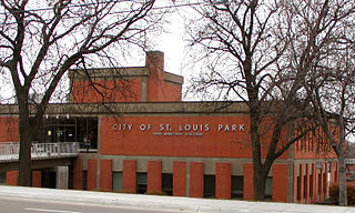
St. Louis Park is a city in Hennepin County, Minnesota, United States. The population was 50,010 at the 2020 census. It is a first-ring suburb immediately west of Minneapolis. Other adjacent cities include Edina, Golden Valley, Minnetonka, Plymouth, and Hopkins.

<span class="mw-page-title-main">Chanhassen, Minnesota</span> City in Minnesota, United States

Chanhassen is a city about 16 miles southwest of Minneapolis in Carver County and partially in Hennepin County, Minnesota, United States. The southwest edge of the Minneapolis–Saint Paul suburbs, there is a mix of residential neighborhoods and rural landscapes. The population was 25,947 at the 2020 census.

References

  1. "2020 U.S. Gazetteer Files". United States Census Bureau. Retrieved July 24, 2022.
  2. 1 2 U.S. Geological Survey Geographic Names Information System: Hopkins, Minnesota
  3. 1 2 3 "Explore Census Data". United States Census Bureau . Retrieved May 1, 2023.
  4. 1 2 "City and Town Population Totals: 2020-2022". United States Census Bureau. January 1, 2024. Retrieved January 1, 2024.
  5. "Hopkins (MN) sales tax rate" . Retrieved January 1, 2024.
  6. "US Gazetteer files 2010". United States Census Bureau. Archived from the original on January 25, 2012. Retrieved November 13, 2012.
  7. "Census of Population and Housing". United States Census Bureau. Retrieved September 11, 2013.
  8. 1 2 "Community Profile" . Retrieved December 1, 2013.
  9. "City Charter" . Retrieved December 1, 2013.
  10. 1 2 "Charter of the City of Hopkins, Minnesota" (PDF). Archived (PDF) from the original on November 5, 2010. Retrieved December 1, 2013.
  11. 1 2 "City Council Structure & Salaries" . Retrieved December 1, 2013.
  12. Hopkins Historical Society (2002). Beverly O. Ewing (ed.). Hopkins Minnesota Through the Years. Hopkins, Minnesota: Hopkins Historical Society. ISBN   0-9727014-0-0.
  13. "City Departments" . Retrieved December 1, 2013.
  14. "Office of the Minnesota Secretary of State - Election Results". Archived from the original on February 22, 2021. Retrieved February 22, 2021.
  15. City of Hopkins website Archived December 11, 2013, at the Wayback Machine , City History webpage
  16. "Minneapolis-Moline". Minnesota Historical Society. Retrieved November 13, 2021.
  17. "How Hopkins Got Its Name".
  18. "Hopkins Mainstreet Added To National Register Of Historic Places".
  19. Hyatt, Kim. "Hopkins' Mainstreet named to the National Register of Historic Places". Star Tribune.
  20. "Open Enrollment". Minnesota Department of Education. Archived from the original on August 26, 2010. Retrieved November 19, 2010.