Iron Range

Last updated

Lake Superior Iron Ranges Iron Ranges.jpg
Lake Superior Iron Ranges

The Iron Range is collectively or individually a number of elongated iron-ore mining districts around Lake Superior in the United States and Canada. Much of the ore-bearing region lies alongside the range of granite hills formed by the Giants Range batholith. [1] These cherty iron ore deposits are Precambrian in the Vermilion Range and middle Precambrian in the Mesabi and Cuyuna ranges, all in Minnesota. The Gogebic Range in Wisconsin and the Marquette Iron Range and Menominee Range in Michigan have similar characteristics and are of similar age. Natural ores and concentrates were produced from 1848 until the mid-1950s, when taconites and jaspers were concentrated and pelletized, and started to become the major source of iron production. [2]

Contents

The mining districts are in Minnesota's Arrowhead region. The region's far eastern area, containing the Duluth Complex along the shore of Lake Superior, and the far northern area, along the Canada–U.S. border, are not associated with iron ore mining, but deposits of copper, nickel, and cobalt at the northern boundary of the Duluth Complex, where it meets the iron formations, are being considered for mining. [3]

The Iron Range and its economy

Iron ore Iron Range-20050725.jpg
Iron ore
Croft Mine Historic Park Croft Mine Park.jpg
Croft Mine Historic Park
Soudan Underground Mine State Park SoudanMine arf.JPG
Soudan Underground Mine State Park

From a geological perspective, Minnesota's Iron Range includes these four major iron deposits: [4]

Within Minnesota, "The Iron Range Resources and Rehabilitation is a State Department, established by the legislature of 1941 to render public service through research and the actual development of all the state's resources both natural and human." [5] The Iron Range Resources and Rehabilitation Board (IRRRB), known as "the I-triple-R-B" or Iron Range Resources, [6] is an economic development agency funded partly by state taxes on taconite-producing companies and charged with creating jobs.

There have been attempts to expand mining for other metals to areas near the Iron Range, most notably with the Twin Metals mine, but these have received pushback from the federal government and environmentalists because of environmental concerns resulting from their proximity to national protected lands. [7]

History

Geologically, the Mesabi, Gunflint, and Cuyuna Ranges in Minnesota belong to the Paleoproterozoic Animikie Group, while the Vermilion Range is Neoarchean. [8] The geologic history of the formations containing iron are typical of banded iron formations worldwide. [2] :502–504

Before the 19th century, Native American groups mined native copper on the Keweenaw Peninsula. [9] William Austin Burt discovered iron ore in the Marquette Range near Negaunee, Michigan in 1844. Iron ore was discovered on the Menominee Range in 1867 and on the Gogebic Range in 1884. It was first discovered in Minnesota on the Vermilion Range in 1885, the Mesabi Range in 1890, and the Cuyuna Range in 1903. [2]

Underground mines were developed to remove the valuable ore of most ranges. But on the Mesabi and Cuyuna Ranges, iron mining operations evolved into enormous open pit mines, where steamshovels and other industrial machines could remove massive amounts of ore. "Large-scale commercial production of magnetite taconite ore on the Mesabi Range started in 1956 at the Peter Mitchell Mine near Babbitt, Minnesota." [2]

Cities and towns

Some of the more significant communities in the region include:

Nearby communities important to the Iron Range:

Culture

Immigrants from over 23 countries settled the area, drawn to the mining industry. By 1910 the Finns were the largest immigrant group, followed by Slovenes and Croats from the Austrian Empire, and Italians and Swedes. [11] Over time the area developed a strong "Ranger" culture and accent. This northern Minnesota accent is still present in the area, especially among older people; hence the popular nickname "da Range". [12]

The regional culture is strongly linked to former periods of steady, usually well-paid mining employment, although in recent decades, the region's outdoor recreation and relative remoteness has attracted new residents unconnected to the industry. [13] There are tensions between supporters and detractors of mining, especially over the potential reuse of ironworks to exploit copper ores. Bob Dylan, who grew up in Hibbing, [14] memorialized the Iron Range in the 1963 song "North Country Blues", a lament portraying hard times in the region. Presented in his 1964 album The Times They Are a-Changin' , it includes such lines as:

So the mining gates locked and the red iron rotted
And the room smelled heavy from drinking
When the sad, silent song made the hour twice as long
As I waited for the sun to go sinking [15]

The Iron Range cuisine is known for Cornish pasties stuffed with a combination of beef, rutabaga, onion, carrots, and potatoes. Pasties were an easy lunch for those working deep in the iron mines. [16] Slovenian and Croatian immigrants brought the honey-nut bread potica to the Iron Range; it is still served on Easter and Christmas in northern Minnesota. [17]

Ice hockey is a predominant sport in the region, which has produced several NHL players as well as the three members of the "Iron Range line" from the 1980 United States men's national ice hockey team that defeated the Soviet Union team in the "Miracle on Ice" game. [18] In 2022, Hockeyland, a documentary focusing on high school hockey in the Iron Range and Duluth area was released. [19] [20]

Politics

Presidential election results (seven core counties) [21]
Year Democratic Republican Others
2020 51.9%100,99745.8% 89,0322.3% 4,387
2016 47.6%85,67343.8% 78,8848.6% 15,465
2012 60.7%111,51836.7% 67,4222.6% 4,747
2008 62.0%116,74935.6% 67,0272.3% 4,411
2004 61.7%116,85637.0% 70,0241.3% 2,521
2000 56.2%94,92336.5% 61,5817.3% 12,277
1996 58.1%91,33327.5% 43,19414.5% 22,749
1992 53.7%90,46424.3% 40,90122.0% 37,034
1988 65.0%102,34834.0% 53,5521.0% 1,631
1984 65.2%112,10534.0% 58,4550.9% 1,497
1980 58.2%102,95232.2% 56,9259.6% 16,975
1976 64.6%110,41132.2% 55,0643.2% 5,518
1972 56.4%87,36742.0% 64,9821.6% 2,550
1968 69.2%104,15126.9% 40,4573.9% 5,806
1964 75.3%116,56724.4% 37,7340.3% 520
1960 62.0%99,70337.5% 60,2830.5% 801

The area has remained a Democratic-Farmer-Labor Party stronghold despite its predominantly white and rural population because of its history of a largely unionized workforce in the mining industry, the mainstay of the economy of the Iron Range. In 2004, John Kerry carried most of the counties in the region by a comfortable margin. This was perhaps aided by George W. Bush calling the area the "Iron Ridge" in a campaign speech. Barack Obama outperformed McCain in 2008, carrying every county in the Range. The area was the largest rural Democratic stronghold in Minnesota outside of the urban centers in Minneapolis and St. Paul.

In 2016, Donald Trump's populist economic policies changed the Range's electoral profile. He won multiple counties, reduced past Democratic winning margins and received endorsements from local Democratic mayors. [22] [23] In the 2022 midterm elections, the Democratic-Farmer-Labor party lost more ground on the Iron Range, with Republican candidates running for lower-profile statewide offices flipping Carlton County. In the state legislature, Republicans picked up several seats on the Range despite losing both chambers overall. Nevertheless, the Range as a whole still votes slightly in favor of Democratic presidential nominees, thanks to Duluth. [24] [25]

Climate

The region is known for harsh winters and pleasant summers. The average year-round temperature is in the 30s °F (between about 2 °C and 4 °C). Temperatures below −40 °F/°C occur somewhere in the region during most winters. The Midwestern Regional Climate Center climate summaries [26] record that Virginia has a mean annual temperature of 38 °F, with an average January low temperature of −6.2 °F (about −21 °C) and July high of 77.4 °F (25 °C). Precipitation there averages 27 in (690 mm) annually and snowfall 53.2 in (135 cm).

See also

Related Research Articles

<span class="mw-page-title-main">St. Louis County, Minnesota</span> County in Minnesota, United States

St. Louis County is a county located in the Arrowhead Region of the U.S. state of Minnesota. As of the 2020 census, the population was 200,231. Its county seat is Duluth. It is the largest county in Minnesota by land area, and the largest in the United States by total area east of the Mississippi River. St. Louis County is included in the Duluth, MN–Superior, WI Metropolitan Statistical Area.

<span class="mw-page-title-main">Ely, Minnesota</span> City in Minnesota, United States

Ely is a city in Saint Louis County, Minnesota, United States. The population was 3,268 at the 2020 census.

<span class="mw-page-title-main">Hibbing, Minnesota</span> City in Minnesota, United States

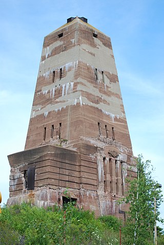
Hibbing is a city in Saint Louis County, Minnesota, United States. The population was 16,214 at the 2020 census. The city was built on mining the rich iron ore of the Mesabi Iron Range and still relies on that industrial activity today. At the edge of town is the world's largest open-pit iron mine, the Hull–Rust–Mahoning Open Pit Iron Mine. It is the hometown of singer-songwriter Bob Dylan and former Governor of Minnesota Rudy Perpich.

<span class="mw-page-title-main">Virginia, Minnesota</span> City in Minnesota, United States

Virginia is a city in St. Louis County, Minnesota, United States, on the Mesabi Iron Range. With an economy heavily reliant on large-scale iron ore mining, Virginia is considered the Mesabi Range's commercial center. The population was 8,423 people at the 2020 census. Virginia is a part of the Duluth metropolitan area, and U.S. Highway 53 runs through town.

<span class="mw-page-title-main">Mesabi Range</span> Mining district in northeastern Minnesota

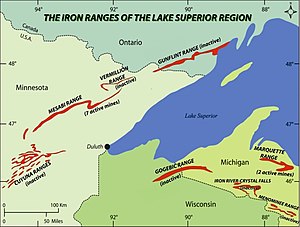
The Mesabi Iron Range is a mining district and mountain range in northeastern Minnesota following an elongate trend containing large deposits of iron ore. It is the largest of four major iron ranges in the region collectively known as the Iron Range of Minnesota. First described in 1866, it is the chief iron ore mining district in the United States. The district is located largely in Itasca and Saint Louis counties. It has been extensively worked since 1892, and has seen a transition from high-grade direct shipping ores through gravity concentrates to the current industry exclusively producing iron ore (taconite) pellets. Production has been dominantly controlled by vertically integrated steelmakers since 1901, and therefore is dictated largely by US ironmaking capacity and demand.

<span class="mw-page-title-main">Taconite</span> Variety of iron-bearing sedimentary rock

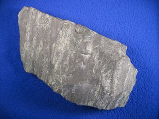
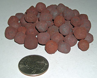
Taconite is a variety of banded iron formation, an iron-bearing sedimentary rock, in which the iron minerals are interlayered with quartz, chert, or carbonate. The name "taconyte" was coined by Horace Vaughn Winchell (1865–1923) – son of Newton Horace Winchell, the Minnesota State Geologist – during their pioneering investigations of the Precambrian Biwabik Iron Formation of northeastern Minnesota. He believed the sedimentary rock sequence hosting the iron-formation was correlative with the Taconic orogeny of New England, and referred to the unfamiliar and as-yet-unnamed iron-bearing rock as the 'taconic rock' or taconyte.

<span class="mw-page-title-main">Duluth, Missabe and Iron Range Railway</span> Railroad operating in northern Minnesota and Wisconsin

The Duluth, Missabe and Iron Range Railway (DM&IR), informally known as the Missabe Road, was a railroad operating in northern Minnesota and Wisconsin that used to haul iron ore and later taconite to the Great Lakes ports of Duluth and Two Harbors, Minnesota. Control of the railway was acquired on May 10, 2004, by the Canadian National Railway (CN) when it purchased the assets of Great Lakes Transportation.

<span class="mw-page-title-main">Arrowhead Region</span> Region in northeastern Minnesota

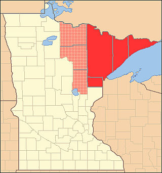
The Arrowhead Region is located in the northeastern part of the U.S. state of Minnesota, so called because of its pointed shape. The predominantly rural region encompasses 10,635.26 square miles (27,545.2 km2) of land area and includes Carlton, Cook, Lake and Saint Louis counties. Its population at the 2000 census was 248,425 residents. The region is loosely defined, and Aitkin, Itasca, and Koochiching counties are sometimes considered as part of the region, increasing the land area to 18,221.97 square miles (47,194.7 km2) and the population to 322,073 residents. Primary industries in the region include tourism and iron mining.

<span class="mw-page-title-main">Vermilion Range (Minnesota)</span> Iron ore deposit in Minnesota

The Vermilion Range exists between Tower, Minnesota and Ely, Minnesota, and contains significant deposits of iron ore. Together with the Mesabi, Gunflint, and Cuyuna ranges, these four constitute the Iron Ranges of northern Minnesota. While the Mesabi Range had iron ore close enough to the surface to enable pit mining, mines had to be dug deep underground to reach the ore of the Vermilion and Cuyuna ranges. The Soudan mine was nearly 1/2 mile underground and required blasting of Precambrian sedimentary bedrock.

<span class="mw-page-title-main">Gunflint Range</span> Iron ore deposit in Minnesota, United States and Ontario, Canada

The Gunflint Range is an iron ore deposit in northern Minnesota in the United States and Northwestern Ontario, Canada. The range extends from the extreme northern portion of Cook County, Minnesota into the Thunder Bay District, Ontario.

<span class="mw-page-title-main">Cuyuna Range</span> Iron mining range in northern Minnesota

The Cuyuna Range is an inactive iron range to the southwest of the Mesabi Range, largely within Crow Wing County, Minnesota. It lies along a 68-mile-long (109 km) line between Brainerd, Minnesota, and Aitkin, Minnesota. The width ranges from 1 to 10 miles.

<span class="mw-page-title-main">North Shore (Lake Superior)</span> Geographic region in the United States and Canada

The North Shore of Lake Superior runs from Duluth, Minnesota, United States, at the western end of the lake, to Thunder Bay and Nipigon, Ontario, Canada, in the north, to Sault Ste. Marie, Ontario in the east. The shore is characterized by alternating rocky cliffs and cobblestone beaches, with forested hills and ridges through which scenic rivers and waterfalls descend as they flow to Lake Superior.

<span class="mw-page-title-main">Cliffs Shaft Mine Museum</span>

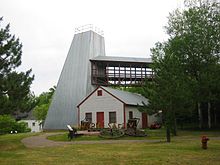
The Cliffs Shaft Mine Museum is a former iron mine, now a heritage museum, located on Euclid Street between Lakeshore Drive and Spruce Street in Ishpeming, Michigan. The museum, operated by "Marquette Range Iron Mining Heritage Theme Park Inc.", celebrates the history of the Marquette Iron Range. The site was designated a state of Michigan historic site in 1973 and placed on the National Register of Historic Places in 1992.

<span class="mw-page-title-main">Hull–Rust–Mahoning Open Pit Iron Mine</span> United States historic place

The Hull–Rust–Mahoning Open Pit Iron Mine in Hibbing, Minnesota, United States, is the largest operating open-pit iron mine in Minnesota. The pit stretches more than three miles (5 km) long, two miles (3 km) wide, and 535 feet (163 m) deep. It was established in 1895 and was one of the world's first mechanized open-pit mines.

<span class="mw-page-title-main">Gogebic Range</span> Iron ore region in Michigan and Wisconsin

The Gogebic Range is an elongated area of iron ore deposits located within a range of hills in northern Michigan and Wisconsin just south of Lake Superior. It extends from Lake Namakagon in Wisconsin eastward to Lake Gogebic in Michigan, or almost 80 miles. Though long, it is only about a half mile wide and forms a crescent concave to the southeast. The Gogebic Range includes the communities of Ironwood in Michigan, plus Mellen and Hurley in Wisconsin.

<span class="mw-page-title-main">Manganese, Minnesota</span> Ghost town in Minnesota, United States

Manganese is a ghost town and former mining community in the U.S. state of Minnesota that was inhabited between 1912 and 1960. It was built in Crow Wing County on the Cuyuna Iron Range in sections 23 and 28 of Wolford Township, about 2 miles (3 km) north of Trommald, Minnesota. After its formal dissolution, Manganese was absorbed by Wolford Township; the former town site is located between Coles Lake and Flynn Lake. First appearing in the U.S. Census of 1920 with an already dwindling population of 183, the village was abandoned by 1960.

<span class="mw-page-title-main">Animikie Group</span> North American geologic group

The Animikie Group is a geologic group composed of sedimentary and metasedimentary rock, having been originally deposited between 2,500 and 1,800 million years ago during the Paleoproterozoic era, within the Animikie Basin. This group of formations is geographically divided into the Gunflint Range, the Mesabi and Vermilion ranges, and the Cuyuna Range. On the map, the Animikie Group is the dark gray northeast-trending belt which ranges from south-central Minnesota, U.S., up to Thunder Bay, Ontario, Canada. The Gunflint Iron Range is the linear black formation labeled G, the Mesabi Iron Range is the jagged black linear formation labeled F, and Cuyuna Iron Range is the two black spots labeled E. The gabbro of the Duluth Complex, intruded during the formation of the Midcontinent Rift, separates the Mesabi and Gunflint iron ranges; it is shown by the speckled area wrapping around the western end of Lake Superior.

<span class="mw-page-title-main">Elcor, Minnesota</span> Ghost town in Minnesota, United States

Elcor is a ghost town, or more properly, an extinct town, in the U.S. state of Minnesota that was inhabited between 1897 and 1956. It was built on the Mesabi Iron Range near the city of Gilbert in St. Louis County. Elcor was its own unincorporated community before it was abandoned and was never a neighborhood proper of the city of Gilbert. Not rating a figure in the national census, the people of Elcor were only generally considered to be citizens of Gilbert. The area where Elcor was located was annexed by Gilbert when its existing city boundaries were expanded after 1969.

<span class="mw-page-title-main">Paulson Mine</span>

The Paulson Mine is a former iron ore mine located in Cook County, Minnesota, United States, 53 kilometres north-west of Grand Marais, Minnesota near the end of the historic Gunflint Trail. The Port Arthur, Duluth and Western Railway was built to the mine in 1892 to access the ore, but both the mine and railway failed.

<span class="mw-page-title-main">Iron mining in the United States</span> Overview of iron mining in the United States

Iron mining in the United States produced 48 million metric tons of iron ore in 2019. Iron ore was the third-highest-value metal mined in the United States, after gold and copper. Iron ore was mined from nine active mines and three reclamation operations in Michigan, Minnesota, and Utah. Most of the iron ore was mined in northern Minnesota's Mesabi Range. Net exports were 3.9 million tons. US iron ore made up 2.5 percent of the total mined worldwide in 2015. Employment as of 2014 was 5,750 in iron mines and iron ore treatment plants.

References

  1. Allison, Ira S. (July 1925). "The Giants Range Batholith of Minnesota". The Journal of Geology. 33 (5): 488–508. doi:10.1086/623215. hdl: 2027/uc1.$b30134 . S2CID   140669590.
  2. 1 2 3 4 Marsden, Ralph (1968). John D. Ridge (ed.). Geology of the Iron Ores of the Lake Superior Region in the United States, in Volume 1 of Ore Deposits of the United States, 1933–1967. The American Institute of Mining, Metallurgical, and Petroleum Engineers, Inc. pp. 490–492.
  3. "Nonferrous Metallic Minerals - Exploration Areas". Minnesota Department of Natural Resources. Retrieved December 14, 2022.
  4. "2 Billion Years Ago: Iron Range Beginnings". Minnesota Historical Society . Archived from the original (Timepieces) on August 9, 2011.
  5. Gruner, John (1946). The Mineralogy and Geology of the Taconites and Iron Ores of the Mesabi Range, Minnesota. Office of the Commissioner of the Iron Range Resources and Rehabilitation. p. Foreword.
  6. "IRRR Advisory Board Members". Department of Iron Range Resources & Rehabilitation.
  7. "Feds issue draft assessment that could doom northern Minnesota mine". KARE-TV. June 24, 2022. Retrieved December 10, 2022.
  8. Lodge et al., 2013, New U–Pb geochronology from Timiskaming-type assemblages in the Shebandowan and Vermilion greenstone belts, Wawa subprovince, Superior Craton: Implications for the Neoarchean development of the southwestern Superior Province, Precambrian Research 235, p. 264-277
  9. "Timeline of Michigan Copper Mining Prehistory to 1850". National Park Service. May 28, 2022. Retrieved October 26, 2022.
  10. Main Injector Neutrino Oscillation Search (MINOS), Soudan Underground Laboratory
  11. LaVigne, David (November 10, 2020). "Immigration to the Iron Range, 1880–1930". MNpedia. Minnesota Historical Society. Retrieved December 19, 2022.
  12. Clara Bingham; Laura Leedy Gansler (October 14, 2003). Class Action: The Landmark Case that Changed Sexual Harassment Law. Knopf Doubleday Publishing Group. pp. 29–34. ISBN   978-0-385-49613-1. OCLC   1005478412.
  13. Erik Kojola. 2020. Divergent memories and visions of the future in conflicts over mining development. Journal of Political Ecology 27: 898-916. https://doi.org/10.2458/v27i1.23210
  14. Bob Dylan's Hibbing. Hibbing, Minnesota: EDLIS Café Press. 2019. ISBN   9781091782891.
  15. "Bob Dylan - North Country Blues Lyrics". Metro Lyrics. Archived from the original on August 2, 2016.
  16. Pease, Krystyna (December 2, 2015). "Appetites: Preserving Iron Range recipes". MPRNews. Minnesota Public Radio.
  17. Ostman, Eleanor (February 21, 2007). "Memories of potica". Chicago Tribune.
  18. "The 1980 U.S. Olympic Team". U.S. Hockey Hall of Fame. Retrieved January 16, 2024.
  19. "New Minnesota documentary looks to be the 'Friday Night Lights' of hockey". MPR News. Retrieved December 10, 2022.
  20. "Inside the making of 'Hockeyland'". ESPN.com. September 14, 2022. Retrieved December 10, 2022.
  21. "Our Campaigns" . Retrieved February 20, 2021.
  22. McGreal, Chris (October 16, 2020). "'The Democratic party left us': how rural Minnesota is making the switch to Trump". the Guardian. Retrieved October 16, 2020.
  23. Slater, Brady (September 4, 2020). "Some Iron Range mayors surprised, disapproving of Trump endorsement". Duluth News Tribune.
  24. "Changing political landscape on the Iron Range". November 10, 2022.
  25. "Iron Range, seething at the Twin Cities, continues right turn". November 11, 2022.
  26. "Midwest Climate: Climate Summaries". Midwestern Regional Climate Center. Retrieved November 1, 2020.

Further reading

47°27′N92°56′W / 47.450°N 92.933°W / 47.450; -92.933