Fridley, Minnesota

Last updated

Fridley
Fridley, Minnesota Civic Campus.jpg
Fridley Civic Campus
Nickname: 
"Friendly Fridley"
Anoka Cnty Minnesota Incorporated and Unincorporated areas Fridley Highlighted.png
Location of the city of Fridley
within Anoka County, Minnesota
Coordinates: 45°05′03″N93°15′24″W / 45.08417°N 93.25667°W / 45.08417; -93.25667
CountryUnited States
State Minnesota
County Anoka
Incorporated (village)June 18, 1949
Incorporated (city)May 23, 1957
Government
  Type Council–manager
Area
[1]
  Total10.88 sq mi (28.18 km2)
  Land10.16 sq mi (26.32 km2)
  Water0.72 sq mi (1.86 km2)
Elevation
[2]
850 ft (260 m)
Population
 (2020) [3]
  Total29,590
  Estimate 
(2022) [4]
30,289
  Density2,911.26/sq mi (1,124.08/km2)
Time zone UTC-6 (Central)
  Summer (DST) UTC-5 (CDT)
ZIP codes
55421, 55432
Area code 763
FIPS code 27-22814 [5]
GNIS feature ID2394826 [2]
Website ci.fridley.mn.us

Fridley is a city in Anoka County, Minnesota, United States. Its population was 29,590 at the 2020 census. [3] It was first settled as a placed named Manomin where Rice Creek flows into the Mississippi river and the Red River Oxcart trail crosses the creek. Fridley was incorporated in 1949 as a village, and became a city in 1957. It is part of the Minneapolis–Saint Paul metropolitan area as a northern "first-ring" or "inner-ring" suburb. Most of the growth in Fridley occurred between 1950 and 1970. [6] Fridley borders Minneapolis to the southwest. Neighboring first-ring suburbs are Columbia Heights to the south and Brooklyn Center to the west, across the Mississippi River.

Contents

Geography and climate

According to the United States Census Bureau, the city has an area of 10.89 square miles (28.20 km2), of which 10.17 square miles (26.34 km2) are land and 0.72 square miles (1.86 km2) is covered by water. [7]

The city lies within a narrow portion of the southernmost part of Anoka County. It is longer north–south along the path of the Mississippi River, and the highways that follow the river. It is narrower east/west in the portion between the Mississippi River and Spring Lake Park.

Fridley borders the cities of Coon Rapids and Blaine to the north; Spring Lake Park to the northeast; Mounds View and New Brighton to the east; Columbia Heights to the southeast; Minneapolis to the southwest; and Brooklyn Park and Brooklyn Center to the west.

Fridley is at the southern edge of the Anoka Sand Plain. [8] Lakes in Fridley include East Moore Lake, West Moore Lake, and Locke Lake. Rice Creek flows through the central part of the city, [9] Springbrook Creek through the northwest section, and the Mississippi River borders Fridley to the west. Parts of islands in the Mississippi River, including the Islands of Peace and Banfill Island, are within the city.

Climate

Fridley shares its climate with nearby Minneapolis. It has a hot-summer humid continental climate zone (Dfa in the Köppen climate classification), [10] typical of southern parts of the Upper Midwest, and is situated in USDA plant hardiness zone 4b. [11] [12] [13] As is typical in a continental climate, the difference between average temperatures in the coldest winter month and the warmest summer month is great: 60.1 °F (33.4 °C).

History

19th century

Fridley's post-European/American settlement history began with the construction of the Red River Trails Woods trail for the Red River ox carts in 1844. [14] The trail traveled through Minnesota Territory from St. Paul to Pembina in present-day North Dakota. It was used to transport furs to the south and other supplies to Red River Valley settlers in the north. The East River Road (Anoka County Highway 1) follows this route today within Fridley, from the border with Minneapolis to the border with Coon Rapids.

Abram M. Fridley, for whom the city is named. AbramMFridley1848.jpg
Abram M. Fridley, for whom the city is named.

In 1847, John Banfill became the first settler in the area, which was known at the time as Manomin. Manomin is a variant spelling of manoomin, the Ojibwe word for wild rice, a staple of their diet. It comprised the modern-day municipalities of Columbia Heights, Fridley, Hilltop, and Spring Lake Park. The Banfill Tavern was built in 1847.

The area soon grew quickly in size. In 1851, Banfill platted the actual town of Manomin. There, a general store and sawmill were built next to Rice Creek, named after Henry Mower Rice, a settler who two years earlier had acquired land in the area. In 1853, the first town post office was in operation, and a year later, a ferry crossing the Mississippi River was established.

In 1855, Abram M. Fridley, for whom the city is named, was elected as the first territorial representative for the area. [15]

In 1857, the area separated from Ramsey County; Manomin County was established, and it became the smallest county in the nation, with only 18 sections. [15] This distinction was short-lived, after it was annexed by Anoka County in 1870 and became a township with the same name. [15]

The Saint Paul and Pacific Railroad, which joined St. Paul to St. Anthony across from Minneapolis in 1862, began extending rail to Anoka, reaching it through Fridley in 1864. [16] [17] [18]

In 1879, the Minnesota State Legislature, of which Abram Fridley was still a member, changed the township's name to bear his name.

20th century

In 1949, Fridley Township was incorporated as the Village of Fridley. [19] The Fridley Free Press was also established. A lawsuit that challenged the village's incorporation caused the funds to be frozen. Minnesota state law allowed cities to operate municipal liquor stores after Prohibition ended. Fridley's liquor store proceeds were the primary funding for daily city operations until the lawsuit was resolved in 1950. Minnesota has both private liquor stores and city-owned municipal liquor stores. [20] Fridley is the location of the headquarters of the Minnesota Municipal Beverage Association (MMBA), a lobbying coalition for municipalities with city-owned liquor stores. In conjunction with the Minnesota Licensed Beverage Association, it lobbied against Sunday liquor store sales in Minnesota until they were finally permitted in 2017.

The Totino's frozen pizza company opened a factory in Fridley in 1970 as they were growing to a national business. [21] The business was sold to Pillsbury in 1975.

Growth

In 1957, the village became the City of Fridley, a "home rule charter city". City Hall, at 6431 University Avenue Northeast, has a fire station, city services and council meetings. A newer fire station was built in 1964. Fridley's population grew past 15,000 in the 1950s and peaked over 30,000 by the 1970s. [6]

1965 flood and tornadoes

Two of Fridley's worst disasters happened within weeks of each other. In April 1965, Minnesota was affected by a "500-year flood". The spring flood on the Upper Mississippi is still the flood of record for from about 100 miles north of Minneapolis to Hannibal, Missouri. The crests that April exceeded previous records by several feet at many river gauge sites. Those record crests still exceed the second-highest crest by a foot or more at many of those sites. [22] An ice jam rising 24 feet over the river broke up when it rammed a series of ice breakers above the Sartell Dam. [23] The Riverview Heights area where Springbrook creek enters the river was severely flooded.

Former Fridley City Hall and Fire Station Number 1 in July 2017 Fridley City Hall July 2017-2.jpg
Former Fridley City Hall and Fire Station Number 1 in July 2017
Former Fridley City hall in July 2017 Fridley City Hall July 2017.jpg
Former Fridley City hall in July 2017

On May 6, 1965, Fridley was hit by two F4 tornadoes. [24] One out of every four homes in the city was destroyed or damaged. The second twister to hit was the deadliest storm in Twin Cities history, killing 13 people. [25] Parts of City Hall and the fire station were damaged. [19]

Post disaster recovery

In 1967, a new Civic Center Building opened at the City Hall location, with a plaza to the south. This building was remodeled in 1989 [19] and demolished in 2019. The acreage around 73rd and (old) Central was purchased by growing Minneapolis-originated companies, Medtronic, Inc. and Onan Corporation, for manufacturing facilities. [26]

Springbrook Nature Center and tornado

In 1970, Fridley began purchasing land that would become the Springbrook Nature Center. On July 18, 1986, a widely photographed tornado spent 16 minutes in Springbrook Nature Center, destroying thousands of century-old trees and extensive areas of mature forest habitat. Well-known aerial footage of the tornado was filmed by a KARE 11 television news helicopter passing through the area. [27]

21st century

Medtronic Operational Headquarters is a major employer in Fridley. Medtronic OHQ Fridley MN 2017.jpg
Medtronic Operational Headquarters is a major employer in Fridley.

In 2001, Medtronic opened its new World Headquarters on the site of the 100 Twin Drive-in at Interstate 694 and Minnesota Highway 65. [29] [30] As of 2019, it is still the Operational Headquarters for Medtronic, PLC, which reorganized as an Irish company in 2015.

On June 19, 2003, President George W. Bush visited the Micro Controls company in Fridley. He was promoting one of the tax relief changes made during his administration. [31] [32]

In the early 2000s, the Minnesota Sports Cafe was a notable venue for mixed martial arts competitions. Fighters who have claimed victories in Fridley include Sean Sherk, Nick Thompson, Brock Larson, Marcus LeVesseur, Brian Ebersole, and Harry Moskowitz.

On September 21, 2005, Fridley was struck by straight-line winds exceeding 80 mph (130 km/h), toppling many old growth trees as large as 2.5 feet (0.76 m) in diameter and destroying dozens of homes and several vehicles. Cleanup efforts took a week, leaving hundreds of residents stranded in their homes without power, unable to drive until streets were cleared of debris. The storm also affected Brooklyn Center, New Brighton, Brooklyn Park, Coon Rapids, Spring Lake Park Blaine, and other communities in the surrounding North Metro area.

Fridley has one of the first six stations of the Northstar Commuter Rail line connecting the northwest suburbs and downtown Minneapolis; the line opened in November 2009. [33]

On July 17, 2011, heavy rains caused a washout of the BNSF rail bridge over Rice Creek. A train derailed there and sent hopper cars containing corn into the creek. [34] Traffic was rerouted for several days. In 2013, a jury awarded damages from BNSF to the engineer and conductor of the train. [35]

The Columbia Arena, filming location for the Disney Movie D3: The Mighty Ducks, was demolished in 2016 to make way for a new City Hall. [36] This was controversial because it was expected to cost $50 million and increase homeowner taxes by 19%. [37] The Fridley Civic Campus dedication at 7071 University Avenue NE was held on November 17, 2018. [38] The staff had moved from the previous city hall over Veteran's Day weekend and began working there on November 12. The city council approved the project in December 2016 after nearly three years of studies, meetings and workshops. The council raised the levy to pay for the project, increasing city taxes about 16% for the average homeowner. [39] A number of other Twin Cities suburbs updated their civic facilities during a 2018 "building boom of sorts", including Eagan, New Hope, Minnetonka, and Burnsville. [40]

Fridley received an allocation of $1.52 million from the American Rescue Plan Act of 2021 (ARPA). [41] The money was used to upgrade and repair its water distribution system and wastewater and storm water infrastructure. [41] The city plans in 2022 to use the next allocation of $1.52 million to improve security at water treatment plants, rebuild its water distribution system, and on sanitary sewer and water quality projects. [41]

President Joe Biden visited the Cummins plant in Fridley on April 3, 2022, as part of his "Investing in America" tour. [42] Cummins had announced a US$1 billion initiative to produce clean energy technology, including electrolysers for hydrogen cells in Fridley. [43] [44]

Economy

Fridley is home to the Operational (formerly World) [45] Headquarters of Ireland-based Medtronic plc. Medtronic also has a substantial Rice Creek business campus. Other major employers in Fridley include BAE Systems (formerly United Defense), Cummins, Unity Medical Center, part of the Allina Healthcare system, part of the Mercy Hospitals, Minco Products, Inc, Kurt Manufacturing Company, and Park Construction Company. Fridley is also home to a Target Stores retail distribution center. Magnum Research, a company that produces the Desert Eagle firearm, had its headquarters in Fridley until 2010.

Minneapolis and Saint Paul draw their municipal water supplies from the Mississippi River at Fridley, which is upstream. [46] The City of Minneapolis Waterworks plant and Fire Department training facility are in Fridley. [46]

In the 2000 census data, there were 11,542 more jobs in Fridley than the number of workers age 16 and over. [47] But most Fridley residents work outside Fridley, most commonly in other cities in Hennepin County and in Minneapolis. Only 21% of the 15,221 Fridley residents in the workforce in 2000 worked in Fridley. Fridley saw a decline in the number of jobs from 26,763 in 2000 to 23,845 in 2006, according to the city economic plan report. [47]

Largest employers

According to the City's 2021 Comprehensive Annual Financial Report, [48] the largest employers in the city are:

#Employer# of Employees
1 Medtronic 3,366
2 Target 1,301
3 Unity Medical Center 1,215
4 Cummins Power (Onan) 1,099
5 Minco Products 592
6Fridley Public Schools ISD #14564
7 BAE Systems 550
8Kurt Manufacturing275
9Taylor Communications250
10 Walmart 212

Education

Fridley's public schools are governed by Fridley Independent School District 14. Fridley High School, Fridley Middle School, Hayes Elementary School, and Stevenson Elementary School comprise the district. In 1978, Fridley closed three elementary schools due to declining enrollment: Gardena, Riverwood, and Parkview. [49] Riverwood Elementary was demolished and single-family homes were developed. Parkview Elementary became the Fridley Community Center. Gardena Elementary became the Al-Amal School. Rice Creek Elementary closed later and was demolished, with single-family homes developed in its place. After the 1965 tornado, students at Parkview had to double up at the Riverwood school while it was being rebuilt.

Totino-Grace High School, a private Roman Catholic high school, Calvin Christian High School, a private Christian high school, and Al-Amal School, a private Islamic K-12 school, are also in Fridley.

A small portion of the northern part of Fridley is within Anoka-Hennepin School District 11. Students living in an area of eastern Fridley are in Columbia Heights School District 13. North Park Elementary is in Fridley. Most of the students living in the north-northeastern part of the city are in Spring Lake Park School District 16. [50] A District 16 elementary school, Woodcrest Spanish Immersion, is in Fridley.

Parks and recreation

Fridley is home to the 127-acre (0.51 km2) Springbrook Nature Center park and nature reserve on its northern border with Coon Rapids. The total Fridley city park space is 316 acres (1.28 km2). [51] There are baseball and softball diamonds, football and soccer fields, basketball courts, and tennis courts for sports. In the winter there are outdoor ice skating rinks with warming houses. The western border of Fridley comprises the Mississippi National River and Recreation Area. Parts of islands in the recreation area are within Fridley's city limits.

Fridley has the following Anoka County parks:

Infrastructure and transportation

Interstate 694 looking West through Fridley Interstate 694 Fridley MN 2017.jpg
Interstate 694 looking West through Fridley

Interstate 694 and Minnesota State Highways 47 and 65 are three of the main automobile routes in the city. East River Road is one of the oldest roads in the state as a Minnesota Territorial road. [52] It was part of the Red River Trails Woods trail. The I-694 Bridge, joining Fridley to Brooklyn Center, is the only crossing of the Mississippi River within the city.

Platform of the Fridley Northstar station looking South towards Minneapolis Fridley MN Station 2017.jpg
Platform of the Fridley Northstar station looking South towards Minneapolis

The BNSF Railway main Northern transcontinental Twin Cities to Portland/Seattle double track line passes through Fridley as part of the Staples Subdivision. [53] [54] The Fridley Station is served by the Northstar Commuter Rail line running on the BNSF tracks into Minneapolis. The Amtrak Empire Builder passes through Fridley twice daily on this line, but does not stop in the city. [55] The massive BNSF Northtown Classification Yards are in the city. [55] The Minnesota Commercial Railway also serves Fridley, with a terminal warehouse there.

BNSF Northtown Classification Yard BNSF Northtown Yard Fridley MN 2017.jpg
BNSF Northtown Classification Yard

The Mississippi River is non-navigable for barge traffic north of the Canadian Pacific Camden Place Rail Bridge, but small boats can travel upstream to the Coon Rapids Dam without a portage. There is a landing for small boats in the river near Interstate 694 at the Anoka County Riverfront Regional Park. [56]

The Anoka County–Blaine Airport serves the area and is in neighboring Blaine.

Nickname

Fridley has the nickname "Friendly Fridley". [57] [58] The nickname was spread further by a long-running series of advertisements on various radio stations for a local car dealer. The announcer directed people to "Friendly Chevrolet up in Friendly Fridley".

The city festival is named "49'er" days, which commemorates the 1949 incorporation. It is usually held in mid-June. [59]

Sister city

Demographics

Historical population
CensusPop.Note
1950 3,796
1960 15,173299.7%
1970 29,23392.7%
1980 30,2283.4%
1990 28,335−6.3%
2000 27,449−3.1%
2010 27,208−0.9%
2020 29,5908.8%
2022 (est.)30,289 [4] 2.4%
U.S. Decennial Census [61]
2020 Census [3]
Historical population
CensusPop.Note
1860 136
1870 103−24.3%
1880 257149.5%
1890 47685.2%
1900 443−6.9%
1910 52318.1%
1920 5331.9%
1930 69330.0%
1940 1,392100.9%
1950 2,27963.7%
U.S. Census for Fridley Township [6]

2010 census

As of the census of 2010, there were 27,208 people, 11,110 households, and 7,057 families residing in the city. The population density was 2,675.3 inhabitants per square mile (1,032.9/km2). There were 11,760 housing units at an average density of 1,156.3 per square mile (446.4/km2). The racial makeup of the city was 75.2% White, 11.1% African American, 1.2% Native American, 4.9% Asian, 0.1% Pacific Islander, 3.4% from other races, and 4.2% from two or more races. Hispanic or Latino of any race were 7.3% of the population.

There were 11,110 households, of which 30.2% had children under the age of 18 living with them, 43.4% were married couples living together, 14.1% had a female householder with no husband present, 6.1% had a male householder with no wife present, and 36.5% were non-families. 28.8% of all households were made up of individuals, and 8.6% had someone living alone who was 65 years of age or older. The average household size was 2.44 and the average family size was 2.99.

The median age in the city was 37.1 years. 23.5% of residents were under the age of 18; 8.8% were between the ages of 18 and 24; 27.9% were from 25 to 44; 25.6% were from 45 to 64; and 14.2% were 65 years of age or older. The gender makeup of the city was 49.5% male and 50.5% female.

2000 census

As of the census of 2000, there were 27,449 people, 11,328 households, and 7,317 families residing in the city. The population density was 2,701.3 inhabitants per square mile (1,043.0/km2). There were 11,504 housing units at an average density of 1,132.1 per square mile (437.1/km2). The racial makeup of the city was 88.65% White, 3.42% African American, 0.82% Native American, 2.89% Asian, 0.07% Pacific Islander, 1.23% from other races, and 2.93% from two or more races. Hispanic or Latino of any race were 2.56% of the population.

There were 11,328 households, out of which 28.2% had children under the age of 18 living with them, 48.6% were married couples living together, 11.6% had a female householder with no husband present, and 35.4% were non-families. 26.8% of all households were made up of individuals, and 6.3% had someone living alone who was 65 years of age or older. The average household size was 2.40 and the average family size was 2.91.

In the city, the population was spread out, with 22.5% under the age of 18, 10.2% from 18 to 24, 31.0% from 25 to 44, 24.4% from 45 to 64, and 12.0% who were 65 years of age or older. The median age was 36 years. For every 100 females, there were 97.8 males. For every 100 females age 18 and over, there were 96.7 males.

The median income for a household in the city was $48,372, and the median income for a family was $55,381. Males had a median income of $38,100 versus $29,997 for females. The per capita income for the city was $23,022. About 5.3% of families and 7.3% of the population were below the poverty line, including 11.9% of those under age 18 and 3.3% of those age 65 or over.

Politics

Fridley has a council-manager government. Scott Lund is the mayor, first elected in 2000.

Fridley is in Minnesota's 5th congressional district, represented by Ilhan Omar, a Democrat.

Notable people

Related Research Articles

<span class="mw-page-title-main">Anoka County, Minnesota</span> County in Minnesota, United States

Anoka County is the fourth-most populous county in the U.S. state of Minnesota. As of the 2020 census, its population was 363,887. The county seat and namesake of the county is the city of Anoka, which is derived from the Dakota word anoka meaning "on both sides", referring to its location on both banks of the Rum River. The largest city in the county is Blaine, the tenth-largest city in Minnesota and the sixth-largest Twin Cities suburb.

<span class="mw-page-title-main">Anoka, Minnesota</span> City in Minnesota, United States

Anoka is a city in and the county seat of Anoka County, Minnesota, United States. Its population was 17,142 at the 2010 census. Anoka is the "Halloween Capital of the World" because it hosted one of the first Halloween parades in 1920. It continues to celebrate the holiday each year with several parades. Anoka is a northern suburb of the Twin Cities. U.S. Highways 10 / 169 and State Highway 47 are three of Anoka's main routes, and it has a station on the Northstar Commuter Rail line to Minneapolis.

<span class="mw-page-title-main">Columbia Heights, Minnesota</span> City in Minnesota, United States

Columbia Heights is a city in Anoka County, Minnesota, United States. The population was 21,973 at the 2020 census.

<span class="mw-page-title-main">Lino Lakes, Minnesota</span> City in Minnesota, United States

Lino Lakes is a city in Anoka County, Minnesota, United States. The population was 21,399 at the 2020 census. Interstates 35W and 35E are two of Lino Lakes's main routes. It is an outer suburb north of the Twin Cities.

Jones Township is the southwesternmost township in Beltrami County, Minnesota, United States. The population was 277 as of the 2000 census. Jones Township was named for an early settler.

<span class="mw-page-title-main">Champlin, Minnesota</span> City in Minnesota, United States

Champlin is a city in Hennepin County, Minnesota, United States. The population was 23,919 at the 2020 census. Champlin is a northern suburb of Minneapolis.

<span class="mw-page-title-main">Eden Prairie, Minnesota</span> City in Minnesota, United States

Eden Prairie is a city 12 miles (19 km) southwest of downtown Minneapolis in Hennepin County and the 16th-largest city in the State of Minnesota, United States. At the 2020 census, it had a population of 64,198. The city is adjacent to the north bank of the Minnesota River, upstream from its confluence with the Mississippi River.

<span class="mw-page-title-main">New Brighton, Minnesota</span> City in Minnesota, United States

New Brighton is a city in Ramsey County, Minnesota, United States. It is a suburb of the Twin Cities. The population was 23,454 at the 2020 census.

<span class="mw-page-title-main">Coon Rapids, Minnesota</span> City in Minnesota, United States

Coon Rapids is a northern suburb of Minneapolis, and is the second-largest city by population in Anoka County, Minnesota, United States. The population was 63,599 at the 2020 census, making it the fifteenth largest city in Minnesota and the seventh largest Twin Cities suburb.

<span class="mw-page-title-main">Mounds View, Minnesota</span> City in Minnesota, United States

Mounds View is a city in Ramsey County, Minnesota, United States. The population was 13,249 at the 2020 census. It is part of the Twin Cities Metropolitan Area.

<span class="mw-page-title-main">Blaine, Minnesota</span> City in Minnesota, United States

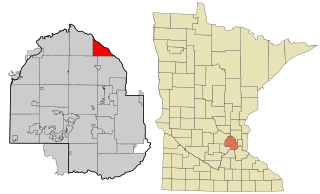
Blaine is a suburban city in Anoka and Ramsey counties in Minnesota, United States. Once a rural town, Blaine's population has increased significantly in the last 60 years. For several years, Blaine led the Twin Cities metro region in new home construction. The population was 70,222 at the 2020 census. The city is mainly in Anoka County, and is part of the Minneapolis–Saint Paul metropolitan area.

<span class="mw-page-title-main">Spring Lake Park, Minnesota</span> City in Minnesota, United States

Spring Lake Park is a city in Anoka and Ramsey counties in the state of Minnesota. The population was 6,412 at the 2010 census. The city is located mainly within Anoka County. Minnesota State Highways 47 and 65 and County Highway 10 are three of the main routes in the city.

<span class="mw-page-title-main">Manomin County, Minnesota</span> County in Minnesota

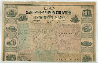
Manomin County was a county in Minnesota that existed separately for 13 years from 1857 to 1870. When it was formed, it was the smallest county in the United States at roughly 16 square miles.. The population in 1860 was 136. This land area currently makes up the unusual southward extension of Anoka County between Hennepin and Ramsey counties. The Manomin County Park in Fridley, at the confluence of Rice Creek and the Mississippi River remains near the former Manomin town site.

The Anoka-Hennepin School District 11 is a school district in Minnesota, northwest of Minneapolis and Saint Paul. The district serves 13 communities: All of Anoka, Champlin and Coon Rapids, and parts of Andover, Blaine, Brooklyn Center, Brooklyn Park, Dayton, Fridley, Ham Lake, Nowthen, Oak Grove and Ramsey. The district's name refers to its geographic span over two counties: it covers the southern portion of Anoka County and the northeast part of Hennepin County. The district was formed in 1920 and in 1952 after dozens of small rural school districts voted to consolidate.

<span class="mw-page-title-main">Rice Creek (Mississippi River tributary)</span> River in Minnesota, United States of America

Rice Creek is a tributary of the Mississippi River in the northern suburbs of the Minneapolis–St. Paul metropolitan area of Minnesota in the United States. It is approximately 28 miles (45 km) long and drains a watershed of 201 square miles (520 km2).

The Northwest Suburban Conference is an athletic conference for all northwest suburban high schools of Minneapolis, Minnesota.

The North Suburban Conference was a Minnesota State High School League recognized high school extracurricular conference including 11 schools located in the northern suburbs of the Twin Cities. The conference disbanded following the 2013-14 school year, after Chisago Lakes, St. Francis, and North Branch announced they would join the Mississippi 8 Conference and Robbinsdale Cooper and St. Louis Park left for the Metro West Conference.

<span class="mw-page-title-main">Fridley station</span>

Fridley station is a commuter rail station in Fridley, Minnesota, located at Main Street NE and 61st Avenue NE. It is served by the Northstar Commuter Rail line. The station features bicycle lockers and two park and ride lots with a total capacity of 611 spaces. The commute time to downtown Minneapolis from this station is about 20 minutes. The station has a single platform on one main track, which is accessible on either side of the tracks through a tunnel.

<span class="mw-page-title-main">Staples Subdivision</span>

The Staples Subdivision or Staples Sub is a railway line running about 227 miles (365 km) from Dilworth to Fridley, Minnesota. It is operated by BNSF Railway as part of their Northern Transcon and contains the busiest segment of mainline track in the state, the segment between Coon Rapids and Fridley. As of 2015, most of the route hosted an average of 60 trains per day, and there were 80 trains per day near Fridley. As of April 2022, the Staples Sub sees about 30-40 trains a day and it’s starting to rise to be more trains again on the line. The line meets the KO Subdivision in the west at East Dilworth, and runs to Interstate in Fridley, at the limits of Northtown Yard. Beyond Northtown, the rails continue as the Midway Subdivision and St. Paul Subdivision. U.S. Highway 10 closely follows the rail line for a majority of the distance between Dilworth and Fridley, Minnesota.

<span class="mw-page-title-main">Banfill Tavern</span> Building in Fridley, Minnesota, United States

The Banfill Tavern, also known as the Locke House, is a historic building in Fridley, Minnesota, United States. It was built in 1847 on the east bank of the Mississippi River and has served variously as an inn, a logging camp office, a private home, a dairy farm, a post office, and a summer home. It is now owned by Anoka County and, until April 2022, housed the non-profit Banfill-Locke Center for the Arts. The building stands within Manomin County Park, and the art center is a partner site of the Mississippi National River and Recreation Area.

References

  1. "2020 U.S. Gazetteer Files". United States Census Bureau. Retrieved July 24, 2022.
  2. 1 2 U.S. Geological Survey Geographic Names Information System: Fridley, Minnesota
  3. 1 2 3 "Explore Census Data". United States Census Bureau . Retrieved March 23, 2023.
  4. 1 2 "City and Town Population Totals: 2020-2022". United States Census Bureau. June 4, 2023. Retrieved June 4, 2023.
  5. "U.S. Census website". United States Census Bureau . Retrieved January 31, 2008.
  6. 1 2 3 United States Census Bureau. "Census of Population and Housing" . Retrieved October 28, 2014.
  7. "US Gazetteer files 2010". United States Census Bureau. Archived from the original on July 2, 2012. Retrieved November 13, 2012.
  8. "Anoka Sand Plain Subsection". Minnesota Department of Natural Resources. Retrieved January 18, 2021.
  9. King's Twin Cities Metro Street Atlas '04. Minneapolis: The Lawrence Group. 2004. ISBN   1-58301-215-X.
  10. Peel, M. C.; Finlayson, B. L.; McMahon, T. A. (October 2007). "Updated world map of the Köppen-Geiger climate classification". Hydrology and Earth System Sciences. 11 (5): 1633–1644. Bibcode:2007HESS...11.1633P. doi: 10.5194/hess-11-1633-2007 .
  11. Normals, Means, and Extremes for Minneapolis/Saint Paul (1971–2000) Archived July 20, 2010, at the Wayback Machine : Mean of Extreme Mins for January
  12. Pioneer Press staff (January 24, 2012). "USDA: Milder winters mean some changes in plant hardiness zones". St. Paul Pioneer Press . Archived from the original on July 21, 2016. Retrieved July 21, 2016.
  13. "USDA Plant Hardiness Zone Map". Agricultural Research Service, U.S. Department of Agriculture. 2012. Archived from the original on February 27, 2014. Retrieved August 14, 2016.
  14. Fridley Historical Society (December 2008). Fridley, Minnesota Its History and People. United States of America: Fridley Historical Society.
  15. 1 2 3 Minnesota History (Volume 5). United States: Minnesota Historical Society, 1923.
  16. Frank G. O'Brien, Minnesota Pioneer Sketches (Minneapolis: H. H. S. Rowell, 1904), 287-288; ―‗Dud‘ Condit, Who Saw railroads Supplant Stage Coaches in Northwest, Declares Conductor‘s Job Was Happiest in World,‖Minneapolis Journal, February 13, 1921
  17. City and State,‖ Minnesota State News (Minneapolis), July 26, 1862; ―First Time Table of the St. Paul and Pacific, Minnesota Historical Society Collections‖; Ralph W. Hidy, Muriel E. Hidy, Roy V. Scott, Don L. Hofsommer, The Great Northern Railway: A History (repr., Minneapolis, London: University of Minnesota Press, 2004), 12; ―A Railroad Excursion Without an Accident,‖ Saint Paul Pioneer, January 19, 1864. The First TimeTable of the St Paul and Pacific does not state the amount of fares charged.
  18. RAPIDS, REINS, RAILS: TRANSPORTATION ON THE Prepared for MINNEAPOLIS RIVERFRONT Marjorie Pearson, Ph.D. Principal Investigator Penny A. Petersen Researcher Hess, Roise and Company. May 2009
  19. 1 2 3 City of Fridley combined city hall fact sheet. City of Fridley, October 2016
  20. Stemmer, Irene - History of the Muni Wayzata Heritage Preservation Board, City of Wayzata, MN. 2009
  21. Johnston, Louis D. - How Totino’s secured Minnesota’s slice of the frozen pizza market. MinnPost April 29, 2021
  22. Boyne, Jeff - 1965 Mississippi River Flood United States National Weather Service (La Crosse Bureau) PD-icon.svg This article incorporates text from this source, which is in the public domain .
  23. Marc Hequet - Mississippi Flood of 1965 —Part 1 [ permanent dead link ] Big River Magazine, March 1994
  24. Curt Brown - Minnesota tornado outbreak still vivid, 50 years later. Star Tribune, May 6, 2015
  25. Summary of May 6, 1965 Tornado Outbreak - NWS Twin Cities
  26. Minnesota Progress. United States: Minnesota Department of Economic Development, 1968.
  27. Heidi Wigdahl - 30 years ago: Sky 11 captures incredible tornado footage. KARE 11 TV, July 18, 2016
  28. "Medtronic Company Profile - locations". Archived from the original on March 4, 2016. Retrieved January 31, 2015.
  29. Medtronic Breaks Ground on New Cardiac Rhythm Management Headquarters. BusinessWire, December 7, 2005 Initially Housing More Than 3,000 Employees, New Facility Will Be Medtronic's Largest in the World
  30. Architecture Minnesota. United States: Minnesota Society American Institute of Architects, 2005. "Medtronic World Headquarters" pg. 86
  31. Bumiller, Elisabeth - In Minnesota, Bush Makes Another Economic Sales Call. New York Times, June 30, 2003
  32. President Discusses Tax Relief in Minnesota White House Archives. June 19, 2003
  33. Paul Levy, Northstar set to roll, but how far?, Star Tribune, December 11, 2007.
  34. Two Injured after Train Derails in Fridley WDAY, July 17, 2017
  35. ABBY SIMONS AND PAUL WALSH - Jury Awards $2.6m for Emotional Damage to Worker in Fridley Derailment Star Tribune, October 29, 2013
  36. Vintage MN Hockey: Columbia Arena
  37. Covington, Hannah - Fridley residents at odds over new city hall complex. Star Tribune, December 2, 2016. Some say time is right to replace the facility, while others want plan brought to a referendum.
  38. Fridley Civic Campus Opening & Dedication. Archived November 25, 2018, at the Wayback Machine City of Fridley, November 17, 2018
  39. Metro Briefs Fridley's new $50 Million civic campus opens this week. Star Tribune, November 10, 2018
  40. Minnetonka Fire, Police Departments Could Soon Get Facility Upgrades. Archived November 25, 2018, at the Wayback Machine KSTP TV, November 14, 2018
  41. 1 2 3 Adler, Erin and Kim Hyatt - Twin Cities suburbs are spending a windfall from the American Rescue Plan Act [ permanent dead link ]. Star Tribune, March 12, 2022
  42. President Biden brings "Investing in America" tour to Twin Cities business. CBS News, April 3, 2023
  43. Cummins to invest over $1 bln to upgrade U.S. facilities to new clean energy tech. Reuters, April 3, 2023<
  44. Cummins U.S. CUMMINS ANNOUNCES INVESTMENTS OF MORE THAN $1 BILLION ACROSS U.S. MANUFACTURING NETWORK - Electrolyzer Product in Fridley, Minnesota Cummins, April 3, 2023, Columbus, Indiana
  45. "Medtronic: About Us". Archived from the original on March 4, 2016. Retrieved January 31, 2015.
  46. 1 2 roper, Eric - How do cities make Mississippi River water safe to drink? Star Tribune, October 9, 2020
  47. 1 2 Chapter 4, Economic and Redevelopment Plan - City of Fridley. Retrieved June 12, 2017
  48. "City of Fridley 2021 Comprehensive Annual Financial Report" (PDF). March 23, 2023. p. 191.
  49. School Closings: Trends and Prospects - State of Minnesota Department of Education. October 1982 https://www.leg.state.mn.us/docs/pre2003/other/821352.pdf
  50. Map and Attendance Boundaries Archived December 29, 2021, at the Wayback Machine - Spring Lake Park Schools
  51. Parks and Trails City of Fridley
  52. Michael Heim (March 2004). Exploring America's Highways: Minnesota Trip Trivia. Exploring America's Highway. pp. 8–. ISBN   978-0-9744358-1-7.
  53. Office of Freight and Commercial Vehicle Operations (May 2013). "Minnesota Freight Railroad Map" (PDF). Minnesota Department of Transportation. Archived from the original (PDF) on February 7, 2014. Retrieved January 27, 2014.
  54. BNSF Rail Network Maps
  55. 1 2 BNSF Northwest Division Timetable No. 2
  56. Riverfront Regional Park Archived May 11, 2018, at the Wayback Machine Anoka County
  57. Spotlight on Fridley; `Friendly' Minneapolis suburb mostly has ramblers, split-level homes. Star Tribune Homes Section (Minneapolis, Minnesota). November 23, 1996. Jim Buchta
  58. City of Fridley Community Development Comprehensive Plan Archived 2007-09-28 at the Wayback Machine Chapter 1 preface (PDF)
  59. "49er Days Parade - City of Fridley". Archived from the original on August 6, 2011. Retrieved September 20, 2011.
  60. "Medtronic France". Archived from the original on August 27, 2014. Retrieved August 26, 2014.
  61. United States Census Bureau. "Census of Population and Housing" . Retrieved September 11, 2013.

Commons-logo.svg Media related to Fridley, Minnesota at Wikimedia Commons