Benton County, Minnesota

Last updated

Benton County
Sts. Peter and Paul Catholic Church, Gilman, MN.JPG
Benton County mn seal.png
Map of Minnesota highlighting Benton County.svg
Location within the U.S. state of Minnesota
Minnesota in United States.svg
Minnesota's location within the U.S.
Coordinates: 45°42′N94°00′W / 45.7°N 94°W / 45.7; -94
CountryFlag of the United States.svg United States
StateFlag of Minnesota.svg  Minnesota
FoundedOctober 27, 1849 (created)
1850 (organized) [1]
Named for Thomas Hart Benton
Seat Foley
Largest city Sauk Rapids
Area
  Total413 sq mi (1,070 km2)
  Land408 sq mi (1,060 km2)
  Water4.8 sq mi (12 km2)  1.2%
Population
 (2020)
  Total41,379
  Estimate 
(2023)
41,600 Increase2.svg
  Density97.9/sq mi (37.8/km2)
Time zone UTC−6 (Central)
  Summer (DST) UTC−5 (CDT)
Congressional district 6th
Website www.co.benton.mn.us

Benton County is a county in the East Central part of the U.S. state of Minnesota. As of the 2020 census, the population was 41,379. [2] Its county seat is Foley. [3]

Contents

Benton County is part of the St. Cloud Metropolitan Statistical Area, which is also included in the Minneapolis-St. Paul Combined Statistical Area.

History

Established in 1849 and organized in 1850, the county is one of the oldest in Minnesota. [4] It was named for Thomas Hart Benton, a United States Senator from Missouri. [5] Its county seat for many years was Sauk Rapids, at the confluence of the Sauk and Mississippi Rivers. The county seat moved to Watab in 1856 and returned to Sauk Rapids in 1859. Sauk Rapids became the terminus of a railroad line in 1874, but was destroyed by a tornado in 1886. In 1897 the county seat moved to Foley, where it remains. As St. Cloud expanded into a metropolitan area, the northern part of Benton County became a suburb.

Geography

The Mississippi River flows southeast along Benton County's western border, and the Platte River flows south through the county's northwest corner, discharging into the Mississippi at the county's western border. The terrain consists of low rolling hills, wooded or devoted to agriculture. [6] It generally slopes to the south and east, although its western portion slopes into the river valleys. The county's highest point is a small hill near the midpoint of the northern border, 1 mi (1.6 km) north of Brennyville, at 1,311 ft (400 m) ASL. [7] The county has a total area of 413 square miles (1,070 km2), of which 408 square miles (1,060 km2) is land and 4.8 square miles (12 km2) (1.2%) is water. [8] It is the fifth-smallest county in Minnesota by land area and fourth-smallest by total area.

Soils of Benton County Benton Co 2016 No Text Version.pdf
Soils of Benton County
Soils of Sartell WMA neighborhood Sartell WMA Wiki Version.jpg
Soils of Sartell WMA neighborhood

Major highways

Adjacent counties

Lakes

[6]

Protected areas

  • Benlacs State Wildlife Management Area (part)
  • Bibles State Wildlife Management Area
  • Englund Ecotone Scientific and Natural Area
  • Sartell State Wildlife Management Area
  • Wisneski State Wildlife Management Area

[6]

Climate and weather

Foley, Minnesota
Climate chart (explanation)
J
F
M
A
M
J
J
A
S
O
N
D
 
 
0.7
 
 
21
2
 
 
0.6
 
 
27
7
 
 
1.6
 
 
39
20
 
 
2.6
 
 
56
33
 
 
3
 
 
69
44
 
 
4.2
 
 
78
54
 
 
3.3
 
 
82
59
 
 
3.8
 
 
80
56
 
 
3.5
 
 
70
47
 
 
2.5
 
 
57
35
 
 
1.4
 
 
39
22
 
 
0.8
 
 
25
7
Average max. and min. temperatures in °F
Precipitation totals in inches
Source: The Weather Channel [10]
Metric conversion
J
F
M
A
M
J
J
A
S
O
N
D
 
 
17
 
 
−6
−17
 
 
16
 
 
−3
−14
 
 
39
 
 
4
−7
 
 
65
 
 
13
1
 
 
75
 
 
21
7
 
 
106
 
 
26
12
 
 
84
 
 
28
15
 
 
96
 
 
27
13
 
 
88
 
 
21
8
 
 
63
 
 
14
2
 
 
35
 
 
4
−6
 
 
21
 
 
−4
−14
Average max. and min. temperatures in °C
Precipitation totals in mm

In recent years, average temperatures in the county seat of Foley have ranged from a low of 2 °F (−17 °C) in January to a high of 82 °F (28 °C) in July, although a record low of −43 °F (−42 °C) was recorded in January 1977 and a record high of 107 °F (42 °C) was recorded in July 1936. Average monthly precipitation ranged from 0.62 inches (16 mm) in February to 4.17 inches (106 mm) in June. [10]

Demographics

Historical population
CensusPop.Note
1850 418
1860 62750.0%
1870 1,558148.5%
1880 3,01293.3%
1890 6,284108.6%
1900 9,91257.7%
1910 11,61517.2%
1920 14,07321.2%
1930 15,0567.0%
1940 16,1067.0%
1950 15,911−1.2%
1960 17,2878.6%
1970 20,84120.6%
1980 25,18720.9%
1990 30,18519.8%
2000 34,22613.4%
2010 38,45112.3%
2020 41,3797.6%
2023 (est.)41,600 [11] 0.5%
U.S. Decennial Census [12]
1790-1960 [13] 1900-1990 [14]
1990-2000 [15] 2010-2020 [2]

2020 census

Benton County Racial Composition [16]
RaceNum.Perc.
White (NH)35,82186.6%
Black or African American (NH)1,9914.81%
Native American (NH)1840.44%
Asian (NH)4631.12%
Pacific Islander (NH)80.02%
Other/Mixed (NH)1,6964.1%
Hispanic or Latino1,2162.94%

2000 census

2022 US Census population pyramid for Benton County, from ACS 5-year estimates BentonCountyMn2022PopPyr.png
2022 US Census population pyramid for Benton County, from ACS 5-year estimates

As of the census of 2000, there were 34,226 people, 13,065 households, and 8,518 families in the county. The population density was 83.9 per square mile (32.4/km2). There were 13,460 housing units at an average density of 33 per square mile (13/km2). The racial makeup of the county was 96.22% White, 0.78% Black or African American, 0.52% Native American, 1.15% Asian, 0.05% Pacific Islander, 0.35% from other races, and 0.94% from two or more races. 0.90% of the population were Hispanic or Latino of any race. 47.8% were of German, 12.1% Polish and 8.8% Norwegian ancestry.

There were 13,065 households, out of which 35.30% had children under the age of 18 living with them, 52.10% were married couples living together, 8.80% had a female householder with no husband present, and 34.80% were non-families. 25.80% of all households were made up of individuals, and 8.90% had someone living alone who was 65 years of age or older. The average household size was 2.56 and the average family size was 3.14.

The county population contained 27.10% under the age of 18, 12.20% from 18 to 24, 31.00% from 25 to 44, 18.70% from 45 to 64, and 11.00% who were 65 years of age or older. The median age was 32 years. For every 100 females, there were 99.60 males. For every 100 females age 18 and over, there were 96.30 males.

The median income for a household in the county was $41,968, and the median income for a family was $51,277. Males had a median income of $33,214 versus $22,737 for females. The per capita income for the county was $19,008. About 4.50% of families and 7.10% of the population were below the poverty line, including 6.30% of those under age 18 and 12.60% of those age 65 or over.

Communities

Cities

Townships

Census-designated place

Unincorporated communities

Ghost towns

[6]

Government and politics

Benton County voters have tended to vote Republican for the past few decades. In 2016 Donald Trump won the county with 64.2%, the highest share of the vote for any presidential candidate since Franklin D. Roosevelt in 1932. [17]

United States presidential election results for Benton County, Minnesota [18]
Year Republican Democratic Third party
No.%No.%No.%
2020 14,38264.61%7,28032.70%5982.69%
2016 12,87264.17%5,64028.12%1,5467.71%
2012 10,84955.30%8,17341.66%5973.04%
2008 10,33853.46%8,45443.71%5472.83%
2004 10,04354.63%8,05943.84%2821.53%
2000 7,66351.40%6,00940.31%1,2368.29%
1996 4,83536.54%6,00645.39%2,39218.08%
1992 5,05335.16%5,15635.88%4,16228.96%
1988 6,06050.33%5,86148.68%1190.99%
1984 6,83057.48%4,92241.42%1311.10%
1980 5,51346.79%5,27244.75%9978.46%
1976 4,09937.38%6,23556.86%6315.75%
1972 4,65249.35%4,28245.43%4925.22%
1968 3,47043.29%4,02250.17%5246.54%
1964 2,81837.47%4,67962.22%230.31%
1960 3,32444.23%4,17555.56%160.21%
1956 3,59157.77%2,60941.97%160.26%
1952 3,85659.54%2,58739.95%330.51%
1948 2,29738.19%3,63260.38%861.43%
1944 2,98856.76%2,25842.90%180.34%
1940 3,49155.76%2,74243.79%280.45%
1936 1,78330.67%3,11153.52%91915.81%
1932 1,32924.84%3,90172.92%1202.24%
1928 2,37346.29%2,73253.30%210.41%
1924 1,62941.90%57214.71%1,68743.39%
1920 2,92078.83%55414.96%2306.21%
1916 1,02049.09%94545.48%1135.44%
1912 46824.38%56229.27%89046.35%
1908 1,00154.11%76541.35%844.54%
1904 1,20571.90%43325.84%382.27%
1900 84951.58%75145.63%462.79%
1896 77846.61%86751.95%241.44%
1892 42625.63%57734.72%65939.65%
County Board of Commissioners [19]
PositionNameDistrict
Commissioner and ChairpersonScott JohnsonDistrict 1
CommissionerEd PoppDistrict 2
CommissionerSteve HeinenDistrict 3
Commissioner and Vice ChairJared J. GapinskiDistrict 4
Commissioner and ChairpersonBeth SchlangenDistrict 5
State Legislature (2022)
PositionNameAffiliationDistrict
Senate Jeff Howe [20] Republican District 13
Senate Aric Putnam [21] Democrat District 14
Senate Andrew Mathews [22] Republican District 15
House of Representatives Tim O'Driscoll [23] Republican District 13B
House of Representatives Dan Wolgamott [24] Democrat District 14B
House of Representatives Shane Mekeland [25] Republican District 15B
U.S Congress (2022)
PositionNameAffiliationDistrict
House of Representatives Tom Emmer [26] Republican 6th
Senate Amy Klobuchar [27] Democrat N/A
Senate Tina Smith [28] Democrat N/A

See also

Related Research Articles

<span class="mw-page-title-main">Todd County, Minnesota</span> County in Minnesota, United States

Todd County is a county in the central part of the U.S. state of Minnesota. As of the 2020 census, the population was 25,262. Its county seat is Long Prairie.

<span class="mw-page-title-main">Stearns County, Minnesota</span> County in Minnesota, United States

Stearns County is a county in the U.S. state of Minnesota. As of the 2020 census, the population was 158,292. Its county seat and largest city is St. Cloud.

<span class="mw-page-title-main">Lincoln County, Minnesota</span> County in Minnesota, United States

Lincoln County is a county in the U.S. state of Minnesota. As of the 2020 census, the population was 5,640. Its county seat is Ivanhoe.

<span class="mw-page-title-main">Hubbard County, Minnesota</span> County in Minnesota, United States

Hubbard County is a county in the northwestern part of the U.S. state of Minnesota. As of the 2020 census, the population was 21,344. Its county seat is Park Rapids.

<span class="mw-page-title-main">Crow Wing County, Minnesota</span> County in Minnesota, United States

Crow Wing County is a county in the East Central part of the U.S. state of Minnesota. As of the 2020 census, the population was 66,123. Its county seat is Brainerd. The county was formed in 1857, and was organized in 1870.

<span class="mw-page-title-main">Foley, Minnesota</span> City in Minnesota, United States

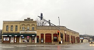
Foley is a city and the county seat of Benton County, Minnesota, United States. The population was 2,711 at the 2020 census.

Graham Township is a township in Benton County, Minnesota, United States. The population was 582 as of the 2010 census.

Mayhew Lake Township is a township in Benton County, Minnesota, United States. The population was 831 as of the 2010 census. Mayhew Lake Township was named for George V. Mayhew, an early settler of Benton County who became a state legislator.

Minden Township is a township in Benton County, Minnesota, United States. The population was 1,514 as of the 2020 census. Minden Township was organized in 1858.

<span class="mw-page-title-main">Rice, Minnesota</span> City in Minnesota, United States

Rice is a city in Benton County, Minnesota, United States. The population was 1,275 at the 2010 census. Its zip code also encompasses Graham, Langola, and Watab townships.

Sauk Rapids Township is a township in Benton County, Minnesota, United States near the Mississippi River. The population was 584 at the 2010 census.

Watab Township is an urban township in Benton County, Minnesota, United States, located north of the mouth of Watab Creek on the opposite side of the Mississippi River in Sartell. The population was 3,093 as of the 2010 census.

<span class="mw-page-title-main">Sauk Rapids, Minnesota</span> City in Minnesota, United States

Sauk Rapids is a city in Benton County, Minnesota, United States. The population was 13,862 at the 2020 census and is 13,896 according to 2021 census estimates, about a third of Benton County's population. It is on a set of rapids on the Mississippi River near its confluence with the Sauk River.

<span class="mw-page-title-main">Royalton, Minnesota</span> City in Minnesota, United States

Royalton is a city in Morrison and Benton counties in the U.S. state of Minnesota, along the Platte River. The population was 1,281 at the 2020 census. The city is located mainly within Morrison County.

<span class="mw-page-title-main">Sartell, Minnesota</span> City in Minnesota, United States

Sartell is a city in Benton and Stearns Counties in the U.S. state of Minnesota that straddles the Mississippi River. It is part of the St. Cloud Metropolitan Statistical Area. The population was 19,351 at the 2020 census, making it St. Cloud's most populous suburb and the fourth-largest city in central Minnesota, after St. Cloud, Elk River, and Willmar.

<span class="mw-page-title-main">St. Cloud, Minnesota</span> City in Minnesota, United States

St. Cloud or Saint Cloud is a city in the U.S. state of Minnesota and the largest population center in the state's central region. The population was 68,881 at the 2020 census, making it Minnesota's 12th-largest city. St. Cloud is the county seat of Stearns County and was named after the city of Saint-Cloud, France, which was named after the 6th-century French monk Clodoald.

Minnesota's 6th congressional district includes most or all of Benton, Carver, Sherburne, Stearns, Wright, and Anoka counties. Many of the Twin Cities' outer northern and western suburbs are included within the boundaries of this district, such as Blaine, Andover, Chaska, Ramsey, St. Michael-Albertville, Elk River, Chanhassen, Otsego, Lino Lakes, Buffalo, Ham Lake, Monticello, Waconia, Big Lake, East Bethel, and Victoria. The St. Cloud Area is the other major center of population for the district, including the cities of St. Cloud, Sartell, Sauk Rapids and Waite Park.

<span class="mw-page-title-main">St. Cloud, Minnesota metropolitan area</span> Metropolitan area in Minnesota, United States

The St. Cloud Metropolitan Statistical Area, as defined by the United States Census Bureau, consists of two counties in central Minnesota, anchored by the city of St. Cloud. In the 2010 census, the MSA had a population of 201,093; a July 1, 2012, Census Bureau estimate placed the population at 190,014. As of the 2020 census, the population was 199,671.

Watab is an unincorporated community in Watab Township, Benton County, Minnesota, United States. The community is located near the junction of River Road and 75th Street. Nearby places include Sauk Rapids, Sartell, and Rice.

Fruitville, also known locally as Fruthville, is an unincorporated community in Mayhew Lake Township, Benton County, Minnesota, United States. The community is located along Benton County Road 13 at 40th Avenue NE near Sauk Rapids and Foley.

References

  1. "Minnesota Place Names". Minnesota Historical Society. Archived from the original on October 29, 2014. Retrieved March 17, 2014.
  2. 1 2 "State & County QuickFacts". United States Census Bureau. Retrieved April 19, 2023.
  3. "Find a County". National Association of Counties. Archived from the original on May 31, 2011. Retrieved June 7, 2011.
  4. "Minnesota State Government Series - State Counties". Minnesota House of Representatives. Archived from the original on March 21, 2012. Retrieved March 2, 2007.
  5. Upham, Warren (1920). Minnesota Geographic Names: Their Origin and Historic Significance. Minnesota Historical Society. p.  49.
  6. 1 2 3 4 Benton County MN Google Maps (accessed March 5, 2019)
  7. Benton County High Point, Minnesota. PeakBagger.com (accessed May 4, 2019)
  8. "2010 Census Gazetteer Files". United States Census Bureau. August 22, 2012. Archived from the original on October 6, 2014. Retrieved October 5, 2014.
  9. Nelson, Steven (2011). Savanna Soils of Minnesota. Minnesota: Self. pp. 61-64. ISBN   978-0-615-50320-2.
  10. 1 2 "Monthly Averages for Foley MN". The Weather Channel. Retrieved November 6, 2011.
  11. "Annual Estimates of the Resident Population for Counties: April 1, 2020 to July 1, 2023" . Retrieved March 18, 2024.
  12. "U.S. Decennial Census". United States Census Bureau. Retrieved October 5, 2014.
  13. "Historical Census Browser". University of Virginia Library. Retrieved October 5, 2014.
  14. "Population of Counties by Decennial Census: 1900 to 1990". United States Census Bureau. Retrieved October 5, 2014.
  15. "Census 2000 PHC-T-4. Ranking Tables for Counties: 1990 and 2000" (PDF). United States Census Bureau. Archived (PDF) from the original on March 27, 2010. Retrieved October 5, 2014.
  16. "P2 Hispanic Or Latino, And Not Hispanic Or Latino By Race – 2020: DEC Redistricting Data (PL 94-171) – Benton County, Minnesota". Census Bureau Data.
  17. Leip, David. "Atlas of US Presidential Elections". Atlas of U.S. Presidential Elections. Archived from the original on March 31, 2018. Retrieved April 17, 2018.
  18. Leip, David. "Atlas of US Presidential Elections". uselectionatlas.org. Retrieved February 21, 2021.
  19. "County Board". Benton County, MN. Archived from the original on January 25, 2023. Retrieved January 25, 2023.
  20. "Senator Jeff R. Howe (13, R)". MN State Senate. Archived from the original on January 25, 2023. Retrieved January 25, 2023.
  21. "Senator Aric Putnam (14, DFL)". MN State Senate. Archived from the original on January 25, 2023. Retrieved January 25, 2023.
  22. "Senator Andrew Mathews (27, R)". MN State Senate. Archived from the original on January 25, 2023. Retrieved January 25, 2023.
  23. "Rep. Tim O'Driscoll (13B)". Minnesota House of Representatives. Archived from the original on January 25, 2023. Retrieved January 25, 2023.
  24. "Rep. Dan Wolgamott (14B)". Minnesota House of Representatives. Archived from the original on January 25, 2023. Retrieved January 25, 2023.
  25. "Rep. Shane Mekeland (15B)". Minnesota House of Representatives. Archived from the original on January 25, 2023. Retrieved January 25, 2023.
  26. "Congressman Tom Emmer". Congressman Tom Emmer. Retrieved June 25, 2020.
  27. "U.S. Senator Amy Klobuchar". klobuchar.senate.gov. Archived from the original on June 24, 2020. Retrieved June 24, 2020.
  28. "Home". Senator Tina Smith. Retrieved June 24, 2020.

45°42′N94°00′W / 45.70°N 94.00°W / 45.70; -94.00