Steele County, Minnesota

Last updated

Steele County
CourthouseSteeleCountyMN.jpg
Map of Minnesota highlighting Steele County.svg
Location within the U.S. state of Minnesota
Minnesota in United States.svg
Minnesota's location within the U.S.
Coordinates: 44°01′N93°13′W / 44.02°N 93.22°W / 44.02; -93.22
CountryFlag of the United States.svg United States
StateFlag of Minnesota.svg  Minnesota
FoundedFebruary 20, 1855
Named for Franklin Steele
Seat Owatonna
Largest cityOwatonna
Area
  Total432 sq mi (1,120 km2)
  Land430 sq mi (1,100 km2)
  Water2.7 sq mi (7 km2)  0.6%
Population
 (2020)
  Total37,406
  Estimate 
(2023)
37,421 Increase2.svg
  Density87.0/sq mi (33.6/km2)
Time zone UTC−6 (Central)
  Summer (DST) UTC−5 (CDT)
Congressional district 1st
Website www.co.steele.mn.us

Steele County is a county in the U.S. state of Minnesota. As of the 2020 census, the population was 37,406. [1] Its county seat is Owatonna. [2]

Contents

Steele County comprises the Owatonna Micropolitan Statistical Area.

History

The county was created by the Minnesota Territory legislature on February 20, 1855, using areas partitioned from Rice, Blue Earth, and Le Sueur counties. Owatonna, the settlement of which had commenced in 1854, was named the county seat. The county was named for Franklin Steele, a prominent early resident of the territory. [3]

Geography

Soils of Steele County Steele Co Pie Chart No Text Version.pdf
Soils of Steele County

The Straight River rises in Freeborn County and flows northward through the central part of Steele County, continuing into Rice County on the north. The South Branch of the Middle Fork of the Zumbro River rises in Steele County and flows eastward into Dodge County. The county terrain consists of low rolling hills, etched with drainages, completely devoted to agriculture where possible. [5] The terrain slopes to the east and north, with its highest point near the midpoint of its south border, at 1,293 ft (394 m) ASL. [6] The county has an area of 432 square miles (1,120 km2), of which 430 square miles (1,100 km2) is land and 2.7 square miles (7.0 km2) (0.6%) is water. [7]

The Straight River flows northward through the county, and the Le Sueur River flows through its southwestern corner. The Middle Fork of the Zumbro River rises in NE Steele County. [8]

Transit

Major highways

Airports [5]

Adjacent counties

Protected areas [5]

Soils of Somerset WMA area Somerset WMA Area New Wiki Version.JPG
Soils of Somerset WMA area
  • Aurora State Wildlife Management Area
  • Oak Glen State Wildlife Management Area
  • Rice Lake State Park
  • Somerset State Wildlife Management Area
  • Swan Lake State Wildlife Management Area

Lakes [5]

  • Beaver
  • Fosilen
  • Kohlmeier
  • Lonergan
  • Oak Glen
  • Rice (part)
  • Rickert
  • Swan

Demographics

Historical population
CensusPop.Note
1860 2,863
1870 8,271188.9%
1880 12,40049.9%
1890 13,2326.7%
1900 16,52424.9%
1910 16,146−2.3%
1920 18,06111.9%
1930 18,4752.3%
1940 19,7496.9%
1950 21,1557.1%
1960 25,02918.3%
1970 26,9317.6%
1980 30,32812.6%
1990 30,7291.3%
2000 33,6809.6%
2010 36,5768.6%
2020 37,4062.3%
2023 (est.)37,421 [9] 0.0%
U.S. Decennial Census [10]
1790-1960 [11] 1900-1990 [12]
1990-2000 [13] 2010-2020 [1]

2020 census

Steele County Racial Composition [14]
RaceNum.Perc.
White (NH)31,37683.9%
Black or African American (NH)1,3593.63%
Native American (NH)650.2%
Asian (NH)3300.9%
Pacific Islander (NH)180.05%
Other/Mixed (NH)1,1183%
Hispanic or Latino3,1408.4%

2000 census

2022 US Census population pyramid for Steele County, from ACS 5-year estimates SteeleCountyMn2022PopPyr.png
2022 US Census population pyramid for Steele County, from ACS 5-year estimates

As of the 2000 census, there were 33,680 people, 12,846 households, and 9,082 families in the county. The population density was 78.3 per square mile (30.2/km2). There were 13,306 housing units at an average density of 30.9 per square mile (11.9/km2). The racial makeup of the county was 95.19% White, 1.07% Black or African American, 0.10% Native American, 0.85% Asian, 0.02% Pacific Islander, 1.65% from other races, and 1.12% from two or more races. 3.76% of the population were Hispanic or Latino of any race. 38.6% were of German, 18.5% Norwegian, 5.2% Czech and 5.1% Irish ancestry.

There were 12,846 households, out of which 35.50% had children under the age of 18 living with them, 59.50% were married couples living together, 7.40% had a female householder with no husband present, and 29.30% were non-families. 24.60% of all households were made up of individuals, and 10.30% had someone living alone who was 65 years of age or older. The average household size was 2.57 and the average family size was 3.08.

The county population contained 27.90% under the age of 18, 8.20% from 18 to 24, 29.00% from 25 to 44, 21.60% from 45 to 64, and 13.30% who were 65 years of age or older. The median age was 36 years. For every 100 females, there were 97.50 males. For every 100 females age 18 and over, there were 95.00 males.

The median income for a household in the county was $46,106, and the median income for a family was $53,981. Males had a median income of $36,366 versus $25,054 for females. The per capita income for the county was $20,328. About 4.20% of families and 6.20% of the population were below the poverty line, including 7.10% of those under age 18 and 7.10% of those age 65 or over.

Communities

Cities

Unincorporated communities

Ghost town

Townships

Politics

Steele County voters have traditionally voted Republican. In only one national election since 1964 has the county selected the Democratic Party candidate (as of 2020).

State Legislature (2021-2023)
PositionNameAffiliationDistrict
Senate John Jasinski [15] Republican District 24
Senate Gene Dornink [16] Republican District 27
House of Representatives John Petersburg [17] Republican District 24A
House of Representatives Brian Daniels [18] Republican District 24A
U.S Congress (2021-2023)
PositionNameAffiliationDistrict
  House of Representatives Brad Finstad [19] Republican 1st
  Senate Amy Klobuchar [20] Democrat
  Senate Tina Smith [21] Democrat
United States presidential election results for Steele County, Minnesota [22]
Year Republican Democratic Third party
No.%No.%No.%
2020 12,65659.90%7,91737.47%5552.63%
2016 11,19858.39%6,24132.54%1,7409.07%
2012 9,90351.78%8,70645.52%5152.69%
2008 10,06851.22%9,01645.87%5722.91%
2004 10,38955.57%7,99442.76%3121.67%
2000 8,22351.18%6,90042.95%9435.87%
1996 5,61737.54%6,97446.61%2,37315.86%
1992 5,96437.77%5,15232.63%4,67329.60%
1988 7,98158.64%5,49640.38%1330.98%
1984 8,78063.12%5,06036.38%700.50%
1980 7,80554.66%5,09535.68%1,3799.66%
1976 7,05351.68%6,26345.89%3312.43%
1972 7,67864.69%4,01033.79%1801.52%
1968 6,19355.34%4,63141.39%3663.27%
1964 4,88244.63%6,02255.05%350.32%
1960 6,79560.13%4,49139.74%150.13%
1956 6,43565.91%3,29333.73%360.37%
1952 6,95670.95%2,81928.75%290.30%
1948 4,45150.49%4,30548.83%600.68%
1944 4,76058.90%3,30740.92%150.19%
1940 5,51759.97%3,66839.87%140.15%
1936 3,37341.01%4,48154.49%3704.50%
1932 3,36543.20%4,31855.43%1071.37%
1928 4,74462.46%2,82637.21%250.33%
1924 3,59859.50%79613.16%1,65327.34%
1920 4,24376.45%1,16721.03%1402.52%
1916 1,73452.20%1,49745.06%912.74%
1912 65120.34%1,29440.44%1,25539.22%
1908 1,89957.11%1,28438.62%1424.27%
1904 2,09563.43%1,06732.30%1414.27%
1900 1,83358.32%1,18837.80%1223.88%
1896 2,04659.41%1,24836.24%1504.36%
1892 1,39648.71%1,29945.32%1715.97%

See also

Related Research Articles

<span class="mw-page-title-main">Grand Forks County, North Dakota</span> County in North Dakota, United States

Grand Forks County is a county in the U.S. state of North Dakota. As of the 2020 census, its population was 73,170, making it the third most populous county in North Dakota. Its county seat and largest community is Grand Forks.

<span class="mw-page-title-main">Dickey County, North Dakota</span> County in North Dakota, United States

Dickey County is a county in the U.S. state of North Dakota. As of the 2020 census, the population was 4,999. Its county seat is Ellendale.

<span class="mw-page-title-main">Waseca County, Minnesota</span> County in Minnesota, United States

Waseca County is a county in the U.S. state of Minnesota. As of the 2020 census, the population was 18,968. Its county seat is Waseca.

<span class="mw-page-title-main">Wabasha County, Minnesota</span> County in Minnesota, United States

Wabasha County is a county in the U.S. state of Minnesota. As of the 2020 census, the population was 21,387. Its county seat is Wabasha.

<span class="mw-page-title-main">Rice County, Minnesota</span> County in Minnesota, United States

Rice County is a county located in the south central portion of the U.S. state of Minnesota. As of the 2020 census, the population was 67,097. Its county seat is Faribault.

<span class="mw-page-title-main">Olmsted County, Minnesota</span> County in Minnesota, United States

Olmsted County is a county in the U.S. state of Minnesota. As of the 2020 census, the population is 162,847. Its county seat and most populous city is Rochester.

<span class="mw-page-title-main">Mahnomen County, Minnesota</span> County in Minnesota, United States

Mahnomen County is a county in the U.S. state of Minnesota. As of the 2020 census, the population was 5,411. Its county seat is Mahnomen.

<span class="mw-page-title-main">Le Sueur County, Minnesota</span> County in Minnesota, United States

Le Sueur County is a county located in the south central portion of the U.S. state of Minnesota. As of the 2020 census, the population was 28,674. Its county seat is Le Center.

<span class="mw-page-title-main">Freeborn County, Minnesota</span> County in Minnesota, United States

Freeborn County is a county in the state of Minnesota. As of the 2020 census, the population was 30,895. Its county seat is Albert Lea. Freeborn County comprises the Albert Lea Micropolitan Statistical Area.

<span class="mw-page-title-main">Dodge County, Minnesota</span> County in Minnesota, United States

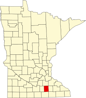
Dodge County is a county in the U.S. state of Minnesota. The population was 20,867 as of the 2020 census. Its county seat is Mantorville.

<span class="mw-page-title-main">Ellendale, Minnesota</span> City in Minnesota, United States

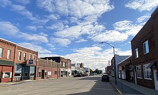
Ellendale is a city in Steele County, Minnesota, United States. The population was 691 at the 2010 census.

Lemond Township is a township in Steele County, Minnesota, United States. The population was 510 at the 2000 census.

<span class="mw-page-title-main">Medford, Minnesota</span> City in Minnesota, United States

Medford is a city in Steele County, Minnesota, United States. The population was 1,239 at the 2010 census.

Medford Township is a township in Steele County, Minnesota, United States. The population was 681 at the 2000 census.

<span class="mw-page-title-main">Owatonna, Minnesota</span> City in Minnesota, United States

Owatonna is a city and the county seat of Steele County, Minnesota, United States. The population was 26,420 at the 2020 census. Owatonna is home to the Steele County Fairgrounds, which hosts the Steele County Free Fair in August.

Zumbro Township is a township in Wabasha County, Minnesota, United States. The population was 715 at the 2000 census. The unincorporated community of South Troy is in Zumbro Township.

<span class="mw-page-title-main">Zumbro Falls, Minnesota</span> City in Minnesota, United States

Zumbro Falls is a city along the Zumbro River in Wabasha County, Minnesota, United States. The population was 207 at the 2010 census. U.S. Highway 63 and Minnesota 60 intersect in Zumbro Falls.

<span class="mw-page-title-main">Mantorville, Minnesota</span> City in Minnesota, United States

Mantorville is a city in Dodge County, Minnesota, United States. The population was 1,197 at the 2010 census. It is the county seat of Dodge County. Founded in 1854, the city is one of the oldest in Minnesota.

<span class="mw-page-title-main">Ellendale, North Dakota</span> City in North Dakota, United States

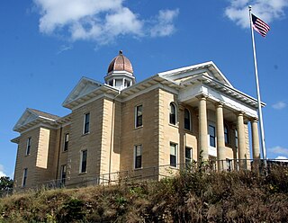
Ellendale is a city in Dickey County, North Dakota, United States. It is the capital city of Dickey County. The population was 1,125 at the 2020 census. Ellendale was founded in 1882. Ellendale is the home of Trinity Bible College, located on the former campus of the North Dakota State Normal and Industrial School and the Ellendale Opera House currently under renovation.

<span class="mw-page-title-main">Blooming Prairie, Minnesota</span> City in Minnesota, United States

Blooming Prairie is a city in Dodge and Steele counties in the U.S. state of Minnesota. The population was 1,996 at the 2010 census. Most of the city is located within Steele County; only a small part of the city extends into Dodge County.

References

  1. 1 2 "State & County QuickFacts". United States Census Bureau. Retrieved April 13, 2023.
  2. "Find a County". National Association of Counties. Retrieved June 7, 2011.
  3. Upham, Warren (1920). Minnesota Geographic Names: Their Origin and Historic Significance. Minnesota Historical Society. p.  531 . Retrieved April 19, 2019.
  4. Nelson, Steven (2011). Savanna Soils of Minnesota. Minnesota: Self. pp. 43-48. ISBN   978-0-615-50320-2.
  5. 1 2 3 4 Steele County MN Google Maps (accessed April 19, 2019)
  6. "Find an Altitude/Steele County MN" Google Maps (accessed April 19, 2019)
  7. "2010 Census Gazetteer Files". United States Census Bureau. August 22, 2012. Archived from the original on September 21, 2013. Retrieved October 25, 2014.
  8. Minnesota Atlas & Gazetteer. Yarmouth ME: DeLorme. 1994. pp. 24, 33. ISBN   0-89933-222-6.
  9. "Annual Estimates of the Resident Population for Counties: April 1, 2020 to July 1, 2023". United States Census Bureau. Retrieved March 18, 2024.
  10. "U.S. Decennial Census". United States Census Bureau. Retrieved October 25, 2014.
  11. "Historical Census Browser". University of Virginia Library. Retrieved October 25, 2014.
  12. "Population of Counties by Decennial Census: 1900 to 1990". United States Census Bureau. Retrieved October 25, 2014.
  13. "Census 2000 PHC-T-4. Ranking Tables for Counties: 1990 and 2000" (PDF). United States Census Bureau. Archived (PDF) from the original on March 27, 2010. Retrieved October 25, 2014.
  14. "P2: Hispanic or Latino, and Not Hispanic or Latino by Race – 2020: DEC Redistricting Data (PL 94-171) – Steele County, Minnesota". United States Census. Archived from the original on February 11, 2023.
  15. "Senator John R. Jasinski (19, R)". MN State Senate. Archived from the original on April 18, 2021. Retrieved April 18, 2021.
  16. Stultz, Sarah (November 5, 2020). "Dornink wins District 27 Senate seat". Albert Lea Tribune. Archived from the original on April 21, 2021. Retrieved April 18, 2021.
  17. "Rep. John Petersburg (24A)". Minnesota House of Representatives. Archived from the original on February 11, 2023. Retrieved April 18, 2021.
  18. "Rep. Brian Daniels (24B)". Minnesota House of Representatives. Archived from the original on February 4, 2023. Retrieved April 18, 2021.
  19. Schnell, Mychael (August 12, 2022). "Republican Rep. Brad Finstad sworn in to finish Hagedorn's House term". The Hill. Archived from the original on October 6, 2022.
  20. "U.S. Senator Amy Klobuchar". klobuchar.senate.gov. Archived from the original on June 24, 2020. Retrieved June 24, 2020.
  21. "Home". Senator Tina Smith. Retrieved June 24, 2020.
  22. Leip, David. "Atlas of US Presidential Elections". uselectionatlas.org. Retrieved October 10, 2018.

44°01′N93°13′W / 44.02°N 93.22°W / 44.02; -93.22