Otter Tail County is a county in the U.S. state of Minnesota. As of the 2020 census, its population was 60,081. Its county seat is Fergus Falls. Otter Tail County comprises the Fergus Falls micropolitan statistical area. With 1,048 lakes in its borders, Otter Tail County has more lakes than any other county in the United States.

Dakota County is the third-most populous county in the U.S. state of Minnesota, located in the east central portion of the state. As of the 2020 census, the population was 439,882. The population of Dakota County was estimated to be 442,038 in 2021. The county seat is Hastings. Dakota County is named for the Dakota Sioux tribal bands who inhabited the area. The name is recorded as "Dahkotah" in the United States Census records until 1851. Dakota County is included in the Minneapolis–St. Paul–Bloomington, MN–WI Metropolitan Statistical Area, the sixteenth largest metropolitan area in the United States with about 3.64 million residents. The largest city in Dakota County is the city of Lakeville, the eleventh-largest city in Minnesota and sixth-largest Twin Cities suburb. The county is bordered by the Minnesota and Mississippi Rivers on the north, and the state of Wisconsin on the east.

Minneapolis–Saint Paul is a metropolitan area in the Upper Midwestern United States centered around the confluence of the Mississippi, Minnesota and St. Croix rivers in the U.S. state of Minnesota. It is commonly known as the Twin Cities after the area's two largest cities, Minneapolis and Saint Paul. Minnesotans often refer to the two together simply as "the cities". It is Minnesota's economic, cultural, and political center.

Scouting in Minnesota has a long history, from the 1910s to the present day, serving thousands of youth in programs that suit the environment in which they live.

Wisconsin has a long history with the Boy Scout and Girl Scout organizations from the 1910s to the present day, both programs have independently served thousands of youth in programs that suit the environment in which they live.

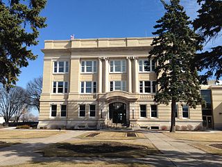
Inver Grove Heights is a city in Dakota County, Minnesota, United States. The population was 35,801 at the 2020 census. The city was formed on March 9, 1965, with the merger of the village of Inver Grove and Inver Grove Township.

Area code 651 is the telephone numbering plan code for Saint Paul, Minnesota, and the eastern suburbs of the Twin Cities. A dogleg portion also extends to the southeast along the Mississippi River to include cities such as Hastings. The region was the fifth area code created in the state in 1998, when it was carved out of area code 612.

Central Minnesota is the central part of the state of Minnesota. No definitive boundaries of the region exist, but most definitions would include the land north of Interstate 94, east of U.S. Highway 59, south of U.S. Highway 2, and west of U.S. Highway 169.

In the U.S. state of Minnesota, a legislative route is a highway number defined by the Minnesota State Legislature. The routes from 1 to 70 are constitutional routes, defined as part of the Babcock Amendment to the Minnesota State Constitution, passed November 2, 1920. All of them were listed in the constitution until a 1974 rewrite. Though they are now listed separately in §161.114 of the Minnesota Statutes, the definitions are legally considered to be part of the constitution, and cannot be altered or removed without an amendment. Legislative routes with numbers greater than 70 can be added or deleted by the legislature.

Independent School District 196 is a K-12 public school district located in the south suburban Twin Cities, near both Minneapolis and St. Paul in Minnesota.

The Forest Preserve District of Cook County is a governmental commission in Cook County, Illinois, that owns and manages a network of open spaces, containing forest, prairie, wetland, streams, and lakes, that are mostly set aside as natural areas. Cook County contains Chicago, and is the center of the most densely populated urban metropolitan area in the Midwest. The Forest Preserve lands encompass approximately 70,000 acres, about 11% of the county, providing open space within its urban surroundings. It contains facilities for recreation, as well as a zoo and a botanic garden.

Minnesota Hockey is the statewide governing body of amateur hockey in Minnesota and an affiliate of USA Hockey. Since 1947, Minnesota Hockey has been providing volunteer services for the development and promotion of all youth hockey in Minnesota. Robert Ridder was the founding president of the MAHA, and affiliated the state group with the Amateur Hockey Association of the United States.
The 2003 Saint John's Johnnies football team represented Saint John's University as a member of the Minnesota Intercollegiate Athletic Conference (MIAC) during the 2003 NCAA Division III football season. In their 51st season under head coach John Gagliardi, the Johnnies compiled a 14–0 record and won the NCAA Division III championship.
This page is based on this
Wikipedia article Text is available under the
CC BY-SA 4.0 license; additional terms may apply.
Images, videos and audio are available under their respective licenses.
