Fillmore County, Minnesota

Last updated

Fillmore County
CourthouseFillmoreCountyMinnesota.JPG
Fillmore County Courthouse
Map of Minnesota highlighting Fillmore County.svg
Location within the U.S. state of Minnesota
Minnesota in United States.svg
Minnesota's location within the U.S.
Coordinates: 43°41′N92°05′W / 43.68°N 92.09°W / 43.68; -92.09
CountryFlag of the United States.svg United States
StateFlag of Minnesota.svg  Minnesota
FoundedMarch 5, 1853
Named for Millard Fillmore
Seat Preston
Largest city Spring Valley
Area
  Total862 sq mi (2,230 km2)
  Land861 sq mi (2,230 km2)
  Water0.8 sq mi (2 km2)  0.09%
Population
 (2020)
  Total21,228
  Estimate 
(2023)
21,522 Increase2.svg
  Density24.6/sq mi (9.5/km2)
Time zone UTC−6 (Central)
  Summer (DST) UTC−5 (CDT)
Congressional district 1st
Website www.co.fillmore.mn.us

Fillmore County is a county in the U.S. state of Minnesota. As of the 2020 census, the population was 21,228. [1] Its county seat is Preston. [2] Fillmore County is included in the Rochester metropolitan area.

Contents

History

Fillmore County was created on March 5, 1853. [3] It is named for Millard Fillmore, the 13th president of the United States. [4] Fillmore County was an early destination for Euro-American settlement following the United States' 1851 treaties with the Dakota nations. Norwegian immigrants were particularly numerous. In 1860 Fillmore was Minnesota's most populous county. [5]

Geography

Fillmore County is on Minnesota's border with Iowa. The Root River drains the county, flowing eastward. The North Branch and the Middle Branch combine east of Shady Creek, while the South Branch meets their combined flow at Preston. Bear Creek drains the lower part of the county, discharging into the Root in the eastern part of the county. Willow Creek also drains a portion of the lower county, discharging into the Root at Preston. The Upper Iowa River flows eastward, mostly in adjoining Iowa counties, but briefly enters Fillmore County near the midpoint of its southern border.

The county's terrain consists of rolling hills, carved by gullies and drainages, with the available area dedicated to agriculture. [6] The terrain slopes to the east; its highest point is on the lower western border, at 1,378 ft (420 m) ASL. [7] The county has a total area of 862 square miles (2,230 km2), of which 861 square miles (2,230 km2) is land and 0.8 square miles (2.1 km2) (0.09%) is water. [8]

The county is part of the Driftless Area or Paleozoic plateau. This part of Minnesota was ice-free during the last ice age. Fillmore County also displays a karst topography.

Soils of Fillmore County Fillmore Co pie chart No Text Version.pdf
Soils of Fillmore County

Major highways

Adjacent counties

Protected areas

Source: [6]

  • Forestville/Mystery Cave State Park
  • Mystery Cave State Park
  • Pin Oak Prairie Scientific and Natural Area
  • Rushford Sand Barrens Scientific and Natural Area
  • Wycoff Balsam Fir Scientific and Natural Area

Demographics

Historical population
CensusPop.Note
1860 13,542
1870 24,88783.8%
1880 28,16213.2%
1890 25,996−7.7%
1900 28,2888.8%
1910 25,680−9.2%
1920 25,330−1.4%
1930 24,748−2.3%
1940 25,8304.4%
1950 24,465−5.3%
1960 23,768−2.8%
1970 21,916−7.8%
1980 21,9300.1%
1990 20,777−5.3%
2000 21,1221.7%
2010 20,866−1.2%
2020 21,2281.7%
2023 (est.)21,522 [10] 1.4%
U.S. Decennial Census [11]
1790-1960 [12] 1900-1990 [13]
1990-2000 [14] 2010-2020 [1]

2020 Census

Fillmore County Racial Composition [15]
RaceNum.Perc.
White (NH)20,17395.03%
Black or African American (NH)980.5%
Native American (NH)70.03%
Asian (NH)710.3%
Pacific Islander (NH)20.01%
Other/Mixed (NH)5362.5%
Hispanic or Latino 3411.6%

2010 census

2022 US Census population pyramid for Fillmore County, from ACS 5-year estimates FillmoreCountyMn2022PopPyr.png
2022 US Census population pyramid for Fillmore County, from ACS 5-year estimates

As of the census of 2010, there were 20,866 people, 8,545 households, and 5,763 families in the county. The population density was 24.2 per square mile (9.3/km2). There were 9,732 housing units at an average density of 11.3 per square mile (4.4/km2). The racial makeup of the county was 98.2% White, 0.2% Black or African American, 0.10% Native American, 0.3% Asian, 0.3% from other races, and 0.8% from two or more races. 1% of the population were Hispanic or Latino of any race.

There were 8,545 households, out of which 29.4% had children under the age of 18 living with them, 56.4% were married couples living together, 7% had a female householder with no husband present, 4% had a male householder with no wife present, and 32.60% were non-families. 28.30% of all households were made up of individuals, and 7.32% had someone living alone who was 65 years of age or older. The average household size was 2.40 and the average family size was 2.94.

The county population contained 24.3% under the age of 18, 6.5% from 18 to 24, 21.9% from 25 to 44, 28.20% from 45 to 64, and 17.10% who were 65 years of age or older. The median age was 43 years. For every 100 females there were 97.30 males. For every 100 females age 18 and over, there were 98.80 males.

In 2010, the median income for a household in the county was $45,888, and the median income for a family was $59,034. Males had a median income of $39,239 versus $33,571 for females. 2015 estimates state the per capita income for the county was $26,348. In 2015, about 7.4% of families and 11.10% of the population were below the poverty line, including 16.50% of those under age 18 and 10.9% of those age 65 or over. [16]

Communities

County landscape in autumn Cattle grazing, Fillmore County, Minnesota.jpg
County landscape in autumn

Cities

Unincorporated communities

Townships

Government and politics

Fillmore County was a swing county until the 2016 presidential election. From 1980 to 2016, the county predicted the president 67% of the time. Since 2016, Fillmore County has shifted rightward and has voted for the Republican nominee by more than 20% each time.

United States presidential election results for Fillmore County, Minnesota [17]
Year Republican Democratic Third party
No.%No.%No.%
2020 7,30160.14%4,55137.48%2892.38%
2016 6,27156.73%3,87235.02%9128.25%
2012 4,91345.11%5,71352.45%2662.44%
2008 4,99344.45%5,92152.71%3202.85%
2004 5,69448.67%5,82549.79%1791.53%
2000 4,64645.45%5,02049.10%5575.45%
1996 3,46635.15%4,73247.99%1,66316.86%
1992 3,58333.62%3,97737.31%3,09829.07%
1988 5,00454.39%4,11444.72%820.89%
1984 6,34258.94%4,35140.44%670.62%
1980 6,45257.04%4,01035.45%8507.51%
1976 5,98454.61%4,75843.42%2151.96%
1972 7,10767.94%3,15530.16%1981.89%
1968 6,25758.99%3,91836.94%4324.07%
1964 4,82445.29%5,81354.58%140.13%
1960 7,50765.60%3,92634.31%110.10%
1956 7,00467.09%3,42732.83%90.09%
1952 8,40576.02%2,61223.62%400.36%
1948 5,58755.16%4,41443.58%1271.25%
1944 6,33966.29%3,18333.29%400.42%
1940 7,83966.98%3,82632.69%390.33%
1936 5,05448.58%4,76445.79%5865.63%
1932 4,97948.22%5,16650.03%1801.74%
1928 7,71977.77%2,14321.59%630.63%
1924 5,55062.75%4605.20%2,83532.05%
1920 7,34185.92%89910.52%3043.56%
1916 2,94565.20%1,31329.07%2595.73%
1912 1,16926.21%99022.20%2,30151.59%
1908 3,25969.85%1,15324.71%2545.44%
1904 3,24280.15%55413.70%2496.16%
1900 3,74169.81%1,36425.45%2544.74%
1896 4,19566.05%1,93930.53%2173.42%
1892 2,92556.53%1,34626.01%90317.45%
County Board of Commissioners [18]
PositionNameDistrictNext Election
CommissionerMitch LentzDistrict 12024
CommissionerRandy DahlDistrict 22026
CommissionerLarry HindtDistrict 32024
CommissionerDuane BakkeDistrict 42026
CommissionerMarc PrestbyDistrict 52024
State Legislature (2021-2023)
PositionNameAffiliationDistrict
Senate Jeremy Miller [19] Republican District 28
House of Representatives Greg Davids [20] Republican District 28B
U.S Congress (2021-2023)
PositionNameAffiliationDistrict
House of Representatives Brad Finstad [21] Republican 1st
Senate Amy Klobuchar [22] Democrat N/A
Senate Tina Smith [23] Democrat N/A

Education

School districts include: [24]

See also

Related Research Articles

<span class="mw-page-title-main">Watonwan County, Minnesota</span> County in Minnesota, United States

Watonwan County is a county in the U.S. state of Minnesota. As of the 2020 census, the population was 11,253. Its county seat is St. James.

<span class="mw-page-title-main">Olmsted County, Minnesota</span> County in Minnesota, United States

Olmsted County is a county in the U.S. state of Minnesota. As of the 2020 census, the population is 162,847. Its county seat and most populous city is Rochester.

<span class="mw-page-title-main">Mower County, Minnesota</span> County in Minnesota, United States

Mower County is a county in the U.S. state of Minnesota. As of the 2020 census, the population was 40,029. The county seat is Austin. Mower County comprises the Austin Micropolitan Statistical Area and is included in the Rochester-Austin Combined Statistical Area. Lake Louise State Park is in southeastern Mower County, near Le Roy.

<span class="mw-page-title-main">Martin County, Minnesota</span> County in Minnesota, United States

Martin County is a county in Minnesota, United States. As of the 2020 census, the population was 20,025. Its county seat is Fairmont.

<span class="mw-page-title-main">Houston County, Minnesota</span> County in Minnesota, United States

Houston County is a county in the U.S. state of Minnesota. At the 2020 census, the population was 18,843. Its county seat is Caledonia.

<span class="mw-page-title-main">Freeborn County, Minnesota</span> County in Minnesota, United States

Freeborn County is a county in the state of Minnesota. As of the 2020 census, the population was 30,895. Its county seat is Albert Lea. Freeborn County comprises the Albert Lea Micropolitan Statistical Area.

<span class="mw-page-title-main">Faribault County, Minnesota</span> County in Minnesota, United States

Faribault County is a county in the U.S. state of Minnesota. As of the 2020 census, the population was 13,921. Its county seat is Blue Earth.

<span class="mw-page-title-main">Crow Wing County, Minnesota</span> County in Minnesota, United States

Crow Wing County is a county in the East Central part of the U.S. state of Minnesota. As of the 2020 census, the population was 66,123. Its county seat is Brainerd. The county was formed in 1857, and was organized in 1870.

<span class="mw-page-title-main">Winneshiek County, Iowa</span> County in Iowa, United States

Winneshiek County is a county located in the U.S. state of Iowa. As of the 2020 census, the population was 20,070. The county seat is Decorah.

<span class="mw-page-title-main">Lanesboro, Minnesota</span> City in Minnesota, United States

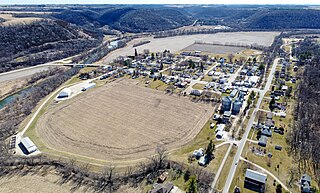
Lanesboro is a city in Fillmore County, Minnesota, United States. The population was 754 at the 2010 census. It was named after F. A. Lane, an early landowner.

<span class="mw-page-title-main">Peterson, Minnesota</span> City in Minnesota, United States

Peterson is a city in Fillmore County, Minnesota, United States. The population was 199 at the 2010 census.

<span class="mw-page-title-main">Preston, Minnesota</span> City in Minnesota, United States

Preston is a city and the county seat of Fillmore County, Minnesota, United States. The population was 1,325 at the 2010 census. The Root River runs through it, and Mystery Cave State Park is nearby. It bills itself as "America's Trout Capital," with a 20-foot trout placed along Minnesota State Highway 16.

<span class="mw-page-title-main">Rushford, Minnesota</span> City in Minnesota, United States

Rushford is a city in Fillmore County, Minnesota, United States. The population was 1,860 at the 2020 census.

<span class="mw-page-title-main">Rushford Village, Minnesota</span> City in Minnesota, United States

Rushford Village is a city in Fillmore County, Minnesota, United States. The population was 807 at the 2010 census. It surrounds the city of Rushford.

<span class="mw-page-title-main">Grand Meadow, Minnesota</span> City in Minnesota, United States

Grand Meadow is a city in Mower County, Minnesota, United States. The city is on the boundary between Grand Meadow Township and Frankford Township, and it is politically independent of both townships. The population was 1,127 at the 2020 census.

<span class="mw-page-title-main">Belle Plaine, Minnesota</span> City in Minnesota, United States

Belle Plaine is a city in Scott County, Minnesota, United States, about 40 minutes southwest of Minneapolis. The population was 7,395 at the 2020 census.

<span class="mw-page-title-main">Minnesota State Highway 250</span> State highway in Minnesota, United States

Minnesota State Highway 250 is a 9.479-mile-long (15.255 km) highway in southeast Minnesota, which runs from its intersection with State Highway 16 in Lanesboro and continues north to its northern terminus at its intersection with State Highway 30 in Arendahl Township. MN 250 passes through Lanesboro, Holt Township, and Arendahl Township.

<span class="mw-page-title-main">Rochester metropolitan area, Minnesota</span> Metropolitan area in the United States

The United States Census Bureau defines the Rochester, Minnesota Metropolitan Statistical Area (MSA) as an area consisting of five counties in southeast Minnesota, anchored by the city of Rochester. As of 2018, the US Census Bureau estimates that the Rochester metropolitan statistical area has a population of 221,587. The Rochester–Austin combined statistical area has a population of 259,813 as of 2018.

<span class="mw-page-title-main">National Register of Historic Places listings in Fillmore County, Minnesota</span>

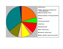
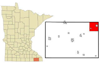
This is a list of the National Register of Historic Places listings in Fillmore County, Minnesota. It is intended to be a complete list of the properties and districts on the National Register of Historic Places in Fillmore County, Minnesota, United States. The locations of National Register properties and districts for which the latitude and longitude coordinates are included below, may be seen in an online map.

<span class="mw-page-title-main">Chatfield, Minnesota</span> City in Minnesota, United States

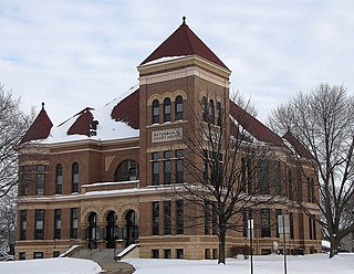
Chatfield is a city in Fillmore and Olmsted counties in the U.S. state of Minnesota. The population was 2,779 at the 2010 census. The city's area is split almost equally between the two counties. Chatfield is known as "The Gateway to Bluff Country" and "The Chosen Valley".

References

  1. 1 2 "State & County QuickFacts". United States Census Bureau. Retrieved April 20, 2023.
  2. "Find a County". National Association of Counties. Archived from the original on May 31, 2011. Retrieved June 7, 2011.
  3. Upham, Warren (1920). Minnesota Geographic Names: Their Origin and Historic Significance. Minnesota Historical Society. p.  190.
  4. Gannett, Henry (1905). The Origin of Certain Place Names in the United States. Govt. Print. Off. p.  125.
  5. Frame III, Robert M. (July 1981). "National Register of Historic Places Inventory—Nomination Form: Fillmore County Multiple Resource Area". National Park Service. Retrieved February 25, 2014.
  6. 1 2 3 4 Fillmore County MN Google Maps (accessed March 8, 2019)
  7. ""Find an Altitude/Fillmore County MN" Google Maps (accessed March 8, 2019)". Archived from the original on May 21, 2019. Retrieved March 8, 2019.
  8. "2010 Census Gazetteer Files". United States Census Bureau. August 22, 2012. Archived from the original on September 21, 2013. Retrieved October 15, 2014.
  9. Nelson, Steven (2011). Savanna Soils of Minnesota. Minnesota: Self. pp. 43-48. ISBN   978-0-615-50320-2.
  10. "Annual Estimates of the Resident Population for Counties: April 1, 2020 to July 1, 2023" . Retrieved March 18, 2024.
  11. "U.S. Decennial Census". United States Census Bureau. Retrieved October 15, 2014.
  12. "Historical Census Browser". University of Virginia Library. Archived from the original on August 11, 2012. Retrieved October 15, 2014.
  13. "Population of Counties by Decennial Census: 1900 to 1990". United States Census Bureau. Retrieved October 15, 2014.
  14. "Census 2000 PHC-T-4. Ranking Tables for Counties: 1990 and 2000" (PDF). United States Census Bureau. Archived (PDF) from the original on March 27, 2010. Retrieved October 15, 2014.
  15. "P2 HISPANIC OR LATINO, AND NOT HISPANIC OR LATINO BY RACE – 2020: DEC Redistricting Data (PL 94-171) – Fillmore County, Minnesota".
  16. "U.S. Census website" . Retrieved July 18, 2017.
  17. Leip, David. "Atlas of US Presidential Elections". uselectionatlas.org. Retrieved April 8, 2018.
  18. "Fillmore County, MN". www.co.fillmore.mn.us. Retrieved April 25, 2023.
  19. "MN State Senate". www.senate.mn. Retrieved June 25, 2020.
  20. "Rep. Greg Davids (28B) - Minnesota House of Representatives". www.house.leg.state.mn.us. Retrieved June 25, 2020.
  21. "Republican Rep. Brad Finstad sworn in to finish Hagedorn's House term". August 12, 2022.
  22. "U.S. Senator Amy Klobuchar". www.klobuchar.senate.gov. Retrieved June 24, 2020.
  23. "Home". Senator Tina Smith. Retrieved June 24, 2020.
  24. "2020 CENSUS - SCHOOL DISTRICT REFERENCE MAP: Fillmore County, MN" (PDF). United States Census Bureau. Archived (PDF) from the original on August 12, 2021. Retrieved July 19, 2022. - Text list

43°41′N92°05′W / 43.68°N 92.09°W / 43.68; -92.09