Canton | |
---|---|
Coordinates: 43°31′48″N91°55′47″W / 43.53000°N 91.92972°W | |
Country | United States |
State | Minnesota |
County | Fillmore |
Area | |
• Total | 1.03 sq mi (2.67 km2) |
• Land | 1.03 sq mi (2.67 km2) |
• Water | 0.00 sq mi (0.00 km2) |
Elevation | 1,345 ft (410 m) |
Population (2020) | |
• Total | 310 |
• Density | 300.68/sq mi (116.14/km2) |
Time zone | UTC-6 (Central (CST)) |
• Summer (DST) | UTC-5 (CDT) |
ZIP code | 55922 |
Area code | 507 |
FIPS code | 27-09802 [2] |
GNIS feature ID | 2393733 [3] |
Canton is a city in Fillmore County, Minnesota, United States. The population was 346 at the 2010 census. [4]
A post office called Canton has been in operation since 1882. [5] Canton was incorporated in 1887. [6] The city was named after Canton, Ohio. [6]
The city was previously served by passenger rail at Canton station.
According to the United States Census Bureau, the city has a total area of 1.00 square mile (2.59 km2), all land. [7]
Canton is along U.S. Highway 52 and Fillmore County Road 21, Main Street. It is five miles east-southeast of Harmony, and nine miles west of Mabel.
Census | Pop. | Note | %± |
---|---|---|---|
1890 | 281 | — | |
1900 | 312 | 11.0% | |
1910 | 345 | 10.6% | |
1920 | 365 | 5.8% | |
1930 | 385 | 5.5% | |
1940 | 421 | 9.4% | |
1950 | 459 | 9.0% | |
1960 | 467 | 1.7% | |
1970 | 391 | −16.3% | |
1980 | 386 | −1.3% | |
1990 | 362 | −6.2% | |
2000 | 343 | −5.2% | |
2010 | 346 | 0.9% | |
2020 | 310 | −10.4% | |
U.S. Decennial Census [8] |
As of the census [9] of 2010, there were 346 people, 162 households, and 88 families living in the city. The population density was 346.0 inhabitants per square mile (133.6/km2). There were 177 housing units at an average density of 177.0 per square mile (68.3/km2). The racial makeup of the city was 99.7% White and 0.3% from two or more races. Hispanic or Latino of any race were 0.6% of the population.
There were 162 households, of which 25.3% had children under the age of 18 living with them, 43.2% were married couples living together, 7.4% had a female householder with no husband present, 3.7% had a male householder with no wife present, and 45.7% were non-families. 40.1% of all households were made up of individuals, and 19.8% had someone living alone who was 65 years of age or older. The average household size was 2.14 and the average family size was 2.88.
The median age in the city was 43.3 years. 23.4% of residents were under the age of 18; 4.9% were between the ages of 18 and 24; 23.4% were from 25 to 44; 30.8% were from 45 to 64; and 17.3% were 65 years of age or older. The gender makeup of the city was 49.7% male and 50.3% female.
As of the census [2] of 2000, there were 500 people, 437 households, and 94 families living in the city. The population density was 341.9 inhabitants per square mile (132.0/km2). There were 171 housing units at an average density of 170.4 per square mile (65.8/km2). The racial makeup of the city was 100.00% White. Hispanic or Latino of any race were 0.29% of the population.
There were 157 households, out of which 27.4% had children under the age of 18 living with them, 45.9% were married couples living together, 9.6% had a female householder with no husband present, and 39.5% were non-families. 33.1% of all households were made up of individuals, and 19.7% had someone living alone who was 65 years of age or older. The average household size was 2.18 and the average family size was 2.79.
In the city, the population was spread out, with 21.9% under the age of 18, 5.2% from 18 to 24, 25.4% from 25 to 44, 22.4% from 45 to 64, and 25.1% who were 65 years of age or older. The median age was 44 years. For every 100 females, there were 86.4 males. For every 100 females age 18 and over, there were 100.0 males.
The median income for a household in the city was $23,409, and the median income for a family was $25,972. Males had a median income of $22,917 versus $21,000 for females. The per capita income for the city was $14,373. About 14.9% of families and 13.2% of the population were below the poverty line, including 18.4% of those under age 18 and 19.8% of those age 65 or over.
Mabel-Canton Public Schools operates area public schools.
The school colors of the pre-merger Canton School were blue and gold. The first graduating class at the Canton School did so in 1914. In 1966 it consolidated into Mabel-Canton. [10]
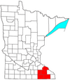
Fillmore County is a county in the U.S. state of Minnesota. As of the 2020 census, the population was 21,228. Its county seat is Preston. Fillmore County is included in the Rochester metropolitan area.
Winneshiek County is a county located in the U.S. state of Iowa. As of the 2020 census, the population was 20,070. The county seat is Decorah.
Payette is a city in and the county seat of Payette County, Idaho, United States. The population was 7,433 at the 2010 census. It is part of the Ontario, OR−ID Micropolitan Statistical Area.
Fillmore is a town in Marion Township, Putnam County, in the U.S. state of Indiana. The population was 533 at the 2010 census.
Coggon is a city in Linn County, Iowa, United States. The population was 701 at the time of the 2020 census. It is part of the Cedar Rapids Metropolitan Statistical Area.
Morrill is a city in Brown County, Kansas, United States. As of the 2020 census, the population of the city was 218.
Brunswick Station was a census-designated place (CDP) within the town of Brunswick in Cumberland County, Maine, United States. The population was 578 at the 2010 census. It consists of an area that was part of the former Naval Air Station Brunswick and was part of the Portland–South Portland–Biddeford, Maine Metropolitan Statistical Area. The 2020 census shows it as part of the Brunswick CDP.
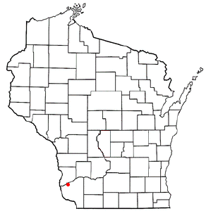
Canton Township is a township in Fillmore County, Minnesota, United States. The population was 684 at the 2000 census.
Fountain is a city in Fillmore County, Minnesota, United States. The population was 410 at the 2010 census. Fountain is the western terminus of the Root River segment of the Root River State Trail. Local attractions include the Fillmore County History Center.
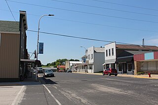
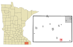
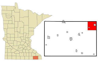
Mabel is a city in Fillmore County, Minnesota, United States. The population was 780 at the 2010 census.
Ostrander is a city in Fillmore County, Minnesota, United States. The population was 254 at the 2010 census.
Rushford Village is a city in Fillmore County, Minnesota, United States. The population was 807 at the 2010 census. It surrounds the city of Rushford.
Whalan is a city in Fillmore County, Minnesota, United States. The population was 63 at the 2010 census.
Wykoff is a city in Fillmore County, Minnesota, United States. The population was 444 at the 2010 census.
Fillmore is a city in Andrew County, Missouri, United States. The population was 184 at the 2010 census.
Unity Village is a village in Jackson County, Missouri, United States, bordering Kansas City and Lee's Summit. It is part of the Kansas City metropolitan area. Its population was 99 at the 2010 census. The founders of the Unity spiritual movement, Charles and Myrtle Fillmore, purchased a 58-acre farm in 1919 as a weekend getaway for employees of their downtown Kansas City headquarters. In March 1920, the land came to be known as Unity Farm, and the following purchase of 12 surrounding farms expanded the land to nearly 1,500 acres.
Ord is a city in Valley County, Nebraska, United States. The population was 2,112 at the 2010 census. It is the county seat of Valley County.
Hume is a town in Allegany County, New York, United States. The population was 2,094 at the 2020 census. The town is on the northern border of Allegany County.
The Town of Millville is a town in Grant County, Wisconsin, United States. The population was 147 at the 2000 census.
Marathon City is a village in Marathon County, Wisconsin, United States. It is part of the Wausau, Wisconsin Metropolitan Statistical Area. The population was 1,524 at the 2010 census. The village was incorporated from a part of the original area of the town of Marathon. The village dates back to 1856. The name of the village commemorates the Battle of Marathon.