Shoreview, Minnesota

Last updated

Shoreview
Ramsey County Minnesota Incorporated and Unincorporated areas Shoreview Highlighted.svg
Location of the city of Shoreview
within Ramsey County, Minnesota
Coordinates: 45°05′03″N93°08′07″W / 45.08417°N 93.13528°W / 45.08417; -93.13528
CountryUnited States
State Minnesota
County Ramsey
Incorporated (city)April 23, 1957
Government
   Mayor Sue Denkinger (elected 2022) [1]
Area
[2]
  Total12.66 sq mi (32.78 km2)
  Land10.77 sq mi (27.89 km2)
  Water1.89 sq mi (4.90 km2)
Elevation
[3]
899 ft (274 m)
Population
 (2020) [4]
  Total26,921
  Estimate 
(2022) [5]
26,632
  Density2,500.33/sq mi (965.42/km2)
Time zone UTC-6 (Central (CST))
  Summer (DST) UTC-5 (CDT)
ZIP code
55126
Area code 651
FIPS code 27-59998 [6]
GNIS feature ID2395876 [3]
Website shoreviewmn.gov

Shoreview is a city in Ramsey County, Minnesota, United States. The population was 26,921 at the time of the 2020 census. [4] In 2008, Shoreview ranked fourth in a Family Circle list of best family towns. [7]

Contents

Geography

According to the United States Census Bureau, the city has a total area of 12.67 square miles (32.82 km2), of which 10.77 square miles (27.89 km2) is land and 1.90 square miles (4.92 km2) is water. [8]

A second-ring suburb north of Saint Paul, Shoreview has nine city parks and three county parks. [9] It has seven lakes, of which the largest are Turtle Lake, Snail Lake, Lake Owasso, and Island Lake, and Rice Creek flows through the northwest portion of the city. [10]

Interstate 35W, Interstate 694, and County Highway 96 are three of its main routes.

Demographics

Historical population
CensusPop.Note
1960 7,157
1970 10,97853.4%
1980 17,30057.6%
1990 24,58742.1%
2000 25,3773.2%
2010 25,043−1.3%
2020 26,9217.5%
2022 (est.)26,632 [5] −1.1%
U.S. Decennial Census [11]
2020 Census [4]

2010 census

As of the census of 2010, there were 25,043 people, 10,402 households, and 6,996 families living in the city. The population density was 2,325.3 inhabitants per square mile (897.8/km2). There were 10,826 housing units at an average density of 1,005.2 per square mile (388.1/km2). The racial makeup of the city was 87.4% White, 2.2% African American, 0.4% Native American, 7.2% Asian, 0.6% from other races, and 2.2% from two or more races. Hispanic or Latino of any race were 2.2% of the population.

There were 10,402 households, of which 28.5% had children under the age of 18 living with them, 56.5% were married couples living together, 7.9% had a female householder with no husband present, 2.8% had a male householder with no wife present, and 32.7% were non-families. 27.3% of all households were made up of individuals, and 9.7% had someone living alone who was 65 years of age or older. The average household size was 2.39 and the average family size was 2.92.

The median age in the city was 44.6 years. 21.6% of residents were under the age of 18; 7.2% were between the ages of 18 and 24; 21.8% were from 25 to 44; 35.1% were from 45 to 64; and 14.4% were 65 years of age or older. The gender makeup of the city was 47.9% male and 52.1% female.

2000 census

As of the census of 2000, there were 25,377 people, Males: 12,303 (48.5%), Females: 13,074 (51.5%), 9,965 households, and 7,021 families living in the city. The population density was 2,315.9 inhabitants per square mile (894.2/km2). There were 10,127 housing units at an average density of 919.2 per square mile (354.9/km2). The racial makeup of the city was 93.28% White, 1.01% African American, 0.22% Native American, 3.65% Asian, 0.05% Pacific Islander, 0.44% from other races, and 1.35% from two or more races. 1.33% of the population were Hispanic or Latino of any race. Ancestries: German (38.3%), Norwegian (15.9%), Swedish (13.9%), Irish (13.9%), English (8.3%), Polish (5.5%). Median resident age: 39.3 years

There were 9,965 households, out of which 34.6% had children under the age of 18 living with them, 60.3% were married couples living together, 7.9% had a female householder with no husband present, and 29.2% were non-families. 24.1% of all households were made up of individuals, and 6.5% had someone living alone who was 65 years of age or older. The average household size was 2.54 and the average family size was 3.06.

In the city, the population was spread out, with 26.2% under the age of 18, 6.9% from 18 to 24, 28.6% from 25 to 44, 28.6% from 45 to 64, and 9.7% who were 65 years of age or older. The median age was 39 years. For every 100 females, there were 94.0 males. For every 100 females age 18 and over, there were 90.3 males.

Education

Shoreview Community Center ShorviewMN(1).JPG
Shoreview Community Center

Two public school districts provide educational services to Shoreview residents: District 621 (Mounds View) and District 623 (Roseville).

The following institutions are located in Shoreview:

St. Odilia's, a private Catholic school, located next to Island Lake school, has a total enrollment of approximately 550 students in grades K–8.

Governance

The Shoreview City Council consists of a Mayor and four council members. The Mayor serves a two-year term of office, and the council members are elected at–large to serve overlapping four year terms. Shoreview has adopted the Plan B Council/Manager form of government, one of three forms permitted by the Minnesota State Legislature. The Council has policymaking and legislative authority and appoints the City Manager, who is charged with the administration of city business in accordance with council decisions. The Manager has the authority to appoint all employees and is responsible for the development of the annual budget.

Economy

Land O'Lakes has a corporate office in Shoreview. [12]

Largest employers

EmployerNumber
Cummins Power Generation800
Deluxe 1,150
Ally 175
DJO Global (Empi Inc.)430
Fiserv 200
Hill-Rom 150
Key Medical Supply40
Land O'Lakes 250
Mead Metals40
Multi-Clean35
Nardini Fire Equipment60
PaR Systems 290
Target 500
TSI Inc.425
Weber Electric75
Wells Fargo 1,200
Westinghouse (PaR Nuclear)325

Broadcasting operations

The majority of FM and television broadcasters in the Twin Cities area have their transmitters and antennae based in Shoreview;

Shoreview made national headlines in September 1971 when a television tower on the site of the current Telefarm Towers collapsed during construction, killing seven workers. [13]

Notable people

Related Research Articles

<span class="mw-page-title-main">Circle Pines, Minnesota</span> City in Minnesota, United States

Circle Pines is a city in Anoka County, Minnesota, United States. The population was 5,025 at the 2020 census.

<span class="mw-page-title-main">Ham Lake, Minnesota</span> City in Minnesota, United States

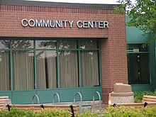
Ham Lake is a city in Anoka County, Minnesota, United States. It is a suburb in the Minneapolis–Saint Paul metropolitan area. The population was 15,296 at the 2010 census. It is in the Anoka-Hennepin School District, one of Minnesota's largest school districts.

<span class="mw-page-title-main">Moose Lake, Minnesota</span> City in Minnesota, United States

Moose Lake is a city in Carlton County, Minnesota, United States. The population was 2,789 at the 2020 census.

<span class="mw-page-title-main">Waconia, Minnesota</span> City in Minnesota, United States

Waconia is a city in Carver County, Minnesota, United States. Waconia attracts visitors to nearby Lake Waconia, a lake locally renowned for its fishing and recreation opportunities.

<span class="mw-page-title-main">Hackensack, Minnesota</span> City in Minnesota, United States

Hackensack is a city in Cass County, Minnesota, United States. The population was 313 at the 2010 census. It is part of the Brainerd Micropolitan Statistical Area.

<span class="mw-page-title-main">Jenkins, Minnesota</span> City in Minnesota, United States

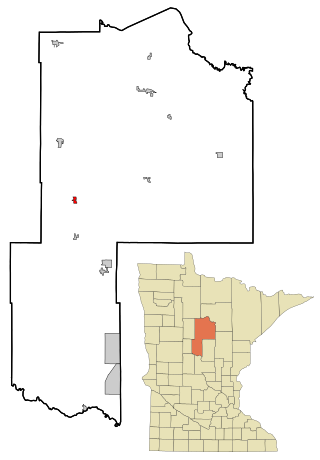
Jenkins is a city in Crow Wing County, Minnesota, United States. The population was 430 at the 2010 census. It is part of the Brainerd Micropolitan Statistical Area.

<span class="mw-page-title-main">Pequot Lakes, Minnesota</span> City in Minnesota, United States

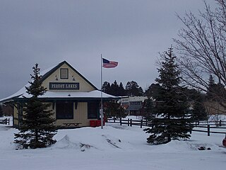
Pequot Lakes is a city in Crow Wing County, Minnesota, United States. The population was 2,162 at the 2010 census. It is part of the Brainerd Micropolitan Statistical Area.

<span class="mw-page-title-main">Minnetrista, Minnesota</span> City in Minnesota, United States

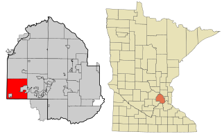
Minnetrista is a city in Hennepin County, Minnesota, United States. Largely rural, Minnetrista has agricultural activity involving corn, soybeans, hay and horses. In addition to farmland and woods, the city is home to several lakes, including part of Lake Minnetonka, the state's ninth-biggest.

<span class="mw-page-title-main">Currie, Minnesota</span> City in Minnesota, United States

Currie is a city in Murray County, Minnesota, United States. The population was 233 at the 2010 census. Lake Shetek State Park is nearby. The city is known as the "Gateway to Lake Shetek". Currie is notable for its tourism, cuisine, and recreational opportunities. It is home to Lakeside Hideaway and the End-O-Line Railroad Park & Museum in addition to being the headquarters of Schmitz Grain. Along with the census-designated area The Lakes, Minnesota, the Currie area has a population of close to 1,000 residents.

<span class="mw-page-title-main">Slayton, Minnesota</span> City in Minnesota, United States

Slayton is a city in and the county seat of Murray County, Minnesota, United States. The population was 2,153 at the 2010 census.

<span class="mw-page-title-main">Little Canada, Minnesota</span> City in Minnesota, United States

Little Canada is a city in Ramsey County, Minnesota, United States. It is a second-ring suburb of Minneapolis-Saint Paul. The population was 10,819 at the 2020 census.

<span class="mw-page-title-main">New Brighton, Minnesota</span> City in Minnesota, United States

New Brighton is a city in Ramsey County, Minnesota, United States. It is a suburb of the Twin Cities. The population was 23,454 at the 2020 census.

<span class="mw-page-title-main">Vadnais Heights, Minnesota</span> City in Minnesota, United States

Vadnais Heights is a city in Ramsey County, Minnesota, United States. The population was 12,302 at the 2010 census.

<span class="mw-page-title-main">Tower, Minnesota</span> City in Minnesota, United States

Tower is a city located in Saint Louis County, Minnesota, United States. As of the 2020 census, the city had a total population of 430. State Highways 1, 169, and 135 are three of the main routes in Tower. Tower is located on the southern shore of Lake Vermilion.

<span class="mw-page-title-main">Woodbury, Minnesota</span> City in Minnesota, United States

Woodbury is a city in Washington County, Minnesota, United States, eight miles east of Saint Paul along Interstate 94. It is part of the Minneapolis–Saint Paul metropolitan area. The population was 75,102 at the 2020 census, making it Minnesota's eighth most populous city.

<span class="mw-page-title-main">Maple Lake, Minnesota</span> City in Minnesota, United States

Maple Lake is a city in Wright County, Minnesota, United States. The population was 2,159 at the 2020 census. Minnesota State Highway 55 serves as a main route in the city.

<span class="mw-page-title-main">Lake Benton, Minnesota</span> City in Minnesota, United States

Lake Benton is a city in Lincoln County, Minnesota, United States. The population was 683 at the 2010 census.

<span class="mw-page-title-main">Battle Lake, Minnesota</span> City in Minnesota, United States

Battle Lake is a city in Otter Tail County, Minnesota, United States. The population was 857 according to the 2020 census.

<span class="mw-page-title-main">Mounds View, Minnesota</span> City in Minnesota, United States

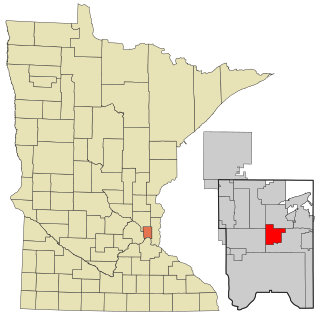
Mounds View is a city in Ramsey County, Minnesota, United States. The population was 12,155 at the 2010 census. It is part of the Twin Cities Metropolitan Area.

<span class="mw-page-title-main">Ortonville, Minnesota</span> City in Minnesota, United States

Ortonville is a city in Big Stone County in the U.S. state of Minnesota at the southern tip of Big Stone Lake, along the border with South Dakota. The population was 2,021 at the 2020 census. It is the county seat of Big Stone County. Big Stone Lake State Park is nearby.

References

  1. City of Shoreview. "Shoreview City Government: Mayor Sue Denkinger" . Retrieved August 21, 2023.
  2. "2020 U.S. Gazetteer Files". United States Census Bureau. Retrieved July 24, 2022.
  3. 1 2 U.S. Geological Survey Geographic Names Information System: Shoreview, Minnesota
  4. 1 2 3 "Explore Census Data". United States Census Bureau . Retrieved October 12, 2023.
  5. 1 2 "City and Town Population Totals: 2020-2022". United States Census Bureau. October 12, 2023. Retrieved October 12, 2023.
  6. "U.S. Census website". United States Census Bureau . Retrieved January 31, 2008.
  7. Weiss, Michael J. "10 Best Towns for Families: 2008". Family Circle. Retrieved April 24, 2011.
  8. "US Gazetteer files 2010". United States Census Bureau. Archived from the original on February 20, 2011. Retrieved November 13, 2012.
  9. Rusler, Verna (2001). Images of America: Shoreview, Minnesota. Chicago: Arcadia Publishing. p. 128. ISBN   0-7385-1860-3.
  10. King's Twin Cities Metro Street Atlas '04. Minneapolis: The Lawrence Group. 2004. ISBN   1-58301-215-X.
  11. United States Census Bureau. "Census of Population and Housing" . Retrieved November 2, 2014.
  12. "Shoreview Office" (Archive) "Land O’Lakes, Inc. Shoreview Office 1080 County Road F West Shoreview, MN 55126 "
  13. Summary of a CBS News report, 9-7-71 http://tvnews.vanderbilt.edu/program.pl?ID=219605 Retrieved on July 12, 2008
  14. Blount, Rachel. "Kyra Condie of Shoreview finishes 11th in first-ever Olympics climbing competition". Minneapolis Star-Tribune . Retrieved October 13, 2023.
  15. "OSDB - Jesper Horsted - Las Vegas Raiders". OSDB - Online Sports Database. Retrieved October 13, 2023.
  16. Olson, Noelle (June 21, 2022). "Shoreview daughter takes comedic talents to the big apple". Shoreview Press. Retrieved October 13, 2023.
  17. Minnesota Legislators Past and Present-Madelyn Reiter