Grant County, Minnesota

Last updated

Grant County
Grant County Courthouse 2012.jpg
Grant County Courthouse
Grant County mn seal.jpg
Map of Minnesota highlighting Grant County.svg
Location within the U.S. state of Minnesota
Minnesota in United States.svg
Minnesota's location within the U.S.
Coordinates: 45°56′N96°01′W / 45.93°N 96.01°W / 45.93; -96.01
CountryFlag of the United States.svg United States
StateFlag of Minnesota.svg  Minnesota
FoundedMarch 6, 1868 (created)
1874 (organized)
Named for Ulysses S. Grant
Seat Elbow Lake
Largest cityElbow Lake
Area
  Total575 sq mi (1,490 km2)
  Land548 sq mi (1,420 km2)
  Water27 sq mi (70 km2)  4.7%
Population
 (2020)
  Total6,074
  Estimate 
(2023)
6,139 Increase2.svg
  Density11.1/sq mi (4.3/km2)
Time zone UTC−6 (Central)
  Summer (DST) UTC−5 (CDT)
Congressional district 7th
Website www.co.grant.mn.us

Grant County is a county in the U.S. state of Minnesota. As of the 2020 census, the population was 6,074. [1] Its county seat is Elbow Lake. [2]

Contents

History

The county was created on March 6, 1868. It was named for Civil War General and US President Ulysses S. Grant. [3] [4] Its government was organized in 1874. [3]

Geography

The Chippewa River flows generally southward through the eastern part of Grant County. The Mustinka River flows south and then west-southwest through the upper and central parts of western Grant County. The terrain consists of low rolling hills dotted with lakes, its usable areas devoted to agriculture. [5] The terrain generally slopes to the south and east; its highest point is on its upper eastern border, at 1,375 ft (419 m) ASL. [6] The county has an area of 575 square miles (1,490 km2), of which 548 square miles (1,420 km2) is land and 27 square miles (70 km2) (4.7%) is water. [7]

Soils of Grant County Grant Co Pie Chart No Text Version.pdf
Soils of Grant County

Major highways

Adjacent counties

Protected areas

Source: [5]

  • Alvstad State Wildlife Management Area
  • Berksow State Wildlife Management Area
  • Chippewa State Wildlife Management Area
  • Helsene State Wildlife Management Area
  • Isaacson State Wildlife Management Area
  • Kube-Swift State Wildlife Management Area
  • Malsville State Wildlife Management Area
  • Marple State Wildlife Management Area
  • Mustinka State Wildlife Management Area
  • Storm-Bordson State Wildlife Management Area
  • Wilts State Wildlife Management Area

Demographics

Historical population
CensusPop.Note
1870 340
1880 3,004783.5%
1890 6,875128.9%
1900 8,93530.0%
1910 9,1142.0%
1920 9,7887.4%
1930 9,558−2.3%
1940 9,8282.8%
1950 9,542−2.9%
1960 8,870−7.0%
1970 7,462−15.9%
1980 7,171−3.9%
1990 6,246−12.9%
2000 6,2890.7%
2010 6,018−4.3%
2020 6,0740.9%
2023 (est.)6,139 [9] 1.1%
U.S. Decennial Census [10]
1790-1960 [11] 1900-1990 [12]
1990-2000 [13] 2010-2020 [1]

2020 Census

Grant County Racial Composition [14]
RaceNum.Perc.
White (NH)5,69993.83%
Black or African American (NH)130.2%
Native American (NH)270.44%
Asian (NH)140.23%
Pacific Islander (NH)70.11%
Other/Mixed (NH)1792.94%
Hispanic or Latino 1352.22%

2000 census

2022 US Census population pyramid for Grant County, from ACS 5-year estimate GrantCountyMn2022PopPyr.png
2022 US Census population pyramid for Grant County, from ACS 5-year estimate

As of the census of 2000, there were 6,289 people, 2,534 households, and 1,740 families in the county. The population density was 11.6 per square mile (4.5/km2). There were 3,098 housing units at an average density of 5.74 per square mile (2.22/km2). The racial makeup of the county was 98.28% White, 0.21% Black or African American, 0.27% Native American, 0.19% Asian, 0.30% from other races, and 0.75% from two or more races. 0.52% of the population were Hispanic or Latino of any race. 41.2% were of Norwegian, 30.0% German and 7.4% Swedish ancestry.

There were 2,534 households, out of which 29.20% had children under the age of 18 living with them, 59.00% were married couples living together, 6.50% had a female householder with no husband present, and 31.30% were non-families. 28.00% of all households were made up of individuals, and 16.50% had someone living alone who was 65 years of age or older. The average household size was 2.40 and the average family size was 2.94.

The county population contained 23.90% under the age of 18, 6.90% from 18 to 24, 23.10% from 25 to 44, 23.20% from 45 to 64, and 22.90% who were 65 years of age or older. The median age was 42 years. For every 100 females there were 94.50 males. For every 100 females age 18 and over, there were 94.30 males.

The median income for a household in the county was $33,775, and the median income for a family was $42,214. Males had a median income of $28,428 versus $20,240 for females. The per capita income for the county was $17,131. About 6.00% of families and 8.40% of the population were below the poverty line, including 9.50% of those under age 18 and 9.90% of those age 65 or over.

Communities

Cities

Unincorporated communities

Ghost towns

Townships

Government and politics

Grant County is a swing district that has leaned Republican in recent elections. As of 2016, the county has selected the Republican presidential candidate in 60% of national elections from 1980 inclusive.

United States presidential election results for Grant County, Minnesota [15]
Year Republican Democratic Third party
No.%No.%No.%
2020 2,26962.10%1,30035.58%852.33%
2016 2,06359.40%1,10531.82%3058.78%
2012 1,74850.13%1,64747.23%922.64%
2008 1,64645.66%1,85051.32%1093.02%
2004 1,89349.57%1,85648.60%701.83%
2000 1,80449.78%1,50741.58%3138.64%
1996 1,28436.05%1,80650.70%47213.25%
1992 1,20132.76%1,56142.58%90424.66%
1988 1,69346.04%1,95053.03%340.92%
1984 2,11152.84%1,86746.73%170.43%
1980 2,05448.08%1,82242.65%3969.27%
1976 1,63537.69%2,62460.49%791.82%
1972 1,89946.84%2,08551.43%701.73%
1968 1,92947.11%1,98248.40%1844.49%
1964 1,73439.72%2,63160.26%10.02%
1960 2,23948.93%2,33350.98%40.09%
1956 2,06449.41%2,10750.44%60.14%
1952 2,66559.51%1,79140.00%220.49%
1948 1,78940.77%2,37854.19%2215.04%
1944 1,89848.93%1,96950.76%120.31%
1940 2,44351.28%2,29148.09%300.63%
1936 1,56638.43%2,35857.87%1513.71%
1932 1,14829.17%2,70268.67%852.16%
1928 2,05754.33%1,68744.56%421.11%
1924 1,67449.21%1183.47%1,61047.33%
1920 2,42775.80%53316.65%2427.56%
1916 87849.19%77843.59%1297.23%
1912 1469.36%38124.42%1,03366.22%
1908 1,09970.04%37623.96%945.99%
1904 1,20987.67%1027.40%684.93%
1900 1,06265.76%45628.24%976.01%
1896 1,00256.29%73941.52%392.19%
1892 77655.35%31922.75%30721.90%
County Board of Commissioners [16]
PositionNameDistrict
Commissioner and ChairpersonTroy JohnsonDistrict 1
CommissionerDwight WalvatneDistrict 2
CommissionerKen JohnsonDistrict 3
CommissionerBill LaValleyDistrict 4
CommissionerDoyle SperrDistrict 5
State Legislature (2021-2023)
PositionNameAffiliationDistrict
 Senate Torrey Westrom [17] Republican District 12
 House of Representatives Jeff Backer [18] Republican District 12A
U.S Congress (2021-2023)
PositionNameAffiliationDistrict
  House of Representatives Michelle Fischbach Republican 7th
  Senate Amy Klobuchar [19] Democrat N/A
  Senate Tina Smith [20] Democrat N/A

See also

Related Research Articles

<span class="mw-page-title-main">Yellow Medicine County, Minnesota</span> County in Minnesota, United States

Yellow Medicine County is a county in the southwestern part of the U.S. state of Minnesota. Its eastern border is formed by the Minnesota River. As of the 2020 census, the population was 9,528. Its county seat is Granite Falls.

<span class="mw-page-title-main">Watonwan County, Minnesota</span> County in Minnesota, United States

Watonwan County is a county in the U.S. state of Minnesota. As of the 2020 census, the population was 11,253. Its county seat is St. James.

<span class="mw-page-title-main">Waseca County, Minnesota</span> County in Minnesota, United States

Waseca County is a county in the U.S. state of Minnesota. As of the 2020 census, the population was 18,968. Its county seat is Waseca.

<span class="mw-page-title-main">Traverse County, Minnesota</span> County in Minnesota, United States

Traverse County is a county in the U.S. state of Minnesota. As of the 2020 census, the population was 3,360, making it the least-populous county in Minnesota. Its county seat is Wheaton. The county was founded in 1862 and organized in 1881.

<span class="mw-page-title-main">Stevens County, Minnesota</span> County in Minnesota, United States

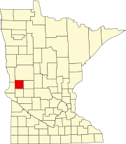
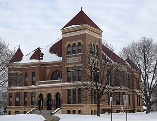
Stevens County is a county in the U.S. state of Minnesota. As of the 2020 census, the population was 9,671. Its county seat is Morris.

<span class="mw-page-title-main">Redwood County, Minnesota</span> County in Minnesota, United States

Redwood County is a county in the U.S. state of Minnesota. As of the 2020 census the population was 15,425. Its county seat is Redwood Falls, along the Redwood River near its confluence with the Minnesota River.

<span class="mw-page-title-main">Pope County, Minnesota</span> County in Minnesota, United States

Pope County is a county in the U.S. state of Minnesota. As of the 2020 census, the population was 11,308. Its county seat is Glenwood. The county was formed in 1862 and organized in 1866.

<span class="mw-page-title-main">Polk County, Minnesota</span> County in Minnesota, United States

Polk County is a county in the northwestern part of the U.S. state of Minnesota. The population was 31,192 at the 2020 census. Its county seat is Crookston, and the largest community is East Grand Forks.

<span class="mw-page-title-main">Murray County, Minnesota</span> County in Minnesota, United States

Murray County is a county in the U.S. state of Minnesota. The population was 8,179 at the 2020 census. Its county seat is Slayton.

<span class="mw-page-title-main">Morrison County, Minnesota</span> County in Minnesota, United States

Morrison County is a county in the U.S. state of Minnesota. As of the 2020 census, the population was 34,010. Its county seat is Little Falls. Camp Ripley Military Reservation occupies a significant area in north-central Morrison County.

<span class="mw-page-title-main">Meeker County, Minnesota</span> County in Minnesota, United States

Meeker County is a county in the U.S. state of Minnesota. As of the 2020 census, the population was 23,400. Its county seat is Litchfield.

<span class="mw-page-title-main">Martin County, Minnesota</span> County in Minnesota, United States

Martin County is a county in Minnesota, United States. As of the 2020 census, the population was 20,025. Its county seat is Fairmont.

<span class="mw-page-title-main">Mahnomen County, Minnesota</span> County in Minnesota, United States

Mahnomen County is a county in the U.S. state of Minnesota. As of the 2020 census, the population was 5,411. Its county seat is Mahnomen.

<span class="mw-page-title-main">Lyon County, Minnesota</span> County in Minnesota, United States

Lyon County is a county in the U.S. state of Minnesota. As of the 2020 census, the population was 25,269. Its county seat is Marshall.

<span class="mw-page-title-main">Lincoln County, Minnesota</span> County in Minnesota, United States

Lincoln County is a county in the U.S. state of Minnesota. As of the 2020 census, the population was 5,640. Its county seat is Ivanhoe.

<span class="mw-page-title-main">Le Sueur County, Minnesota</span> County in Minnesota, United States

Le Sueur County is a county located in the south central portion of the U.S. state of Minnesota. As of the 2020 census, the population was 28,674. Its county seat is Le Center.

<span class="mw-page-title-main">Kandiyohi County, Minnesota</span> County in Minnesota, United States

Kandiyohi County is a county in the U.S. state of Minnesota. As of the 2020 census, its population is 43,732. As of November 20, 1871, its county seat is Willmar.

<span class="mw-page-title-main">Douglas County, Minnesota</span> County in Minnesota, United States

Douglas County is a county in the U.S. state of Minnesota. As of the 2020 census, the population was 39,006. Its county seat is Alexandria.

<span class="mw-page-title-main">Clearwater County, Minnesota</span> County in Minnesota, United States

Clearwater County is a county in the northwestern part of the U.S. state of Minnesota. As of the 2020 census, the population was 8,524. Its county seat is Bagley.

<span class="mw-page-title-main">Big Stone County, Minnesota</span> County in Minnesota, United States

Big Stone County is a county in the U.S. state of Minnesota. As of the 2020 census, the population was 5,166. Its county seat is Ortonville.

References

  1. 1 2 "State & County QuickFacts". United States Census Bureau. Retrieved April 10, 2023.
  2. "Find a County". National Association of Counties. Archived from the original on May 31, 2011. Retrieved June 7, 2011.
  3. 1 2 "Minnesota Place Names". Minnesota Historical Society. p. 213. Retrieved March 9, 2019.
  4. Gannett, Henry (1905). The Origin of Certain Place Names in the United States. Govt. Print. Off. p.  141.
  5. 1 2 Grant County MN Google Maps (accessed March 9, 2019)
  6. ""Find an Altitude/Grant County MN" Google Maps (accessed March 9, 2019)". Archived from the original on May 21, 2019. Retrieved March 9, 2019.
  7. "2010 Census Gazetteer Files". United States Census Bureau. August 22, 2012. Archived from the original on October 6, 2014. Retrieved October 15, 2014.
  8. Nelson, Steven (2011). Savanna Soils of Minnesota. Minnesota: Self. pp. 65-67. ISBN   978-0-615-50320-2.
  9. "Annual Estimates of the Resident Population for Counties: April 1, 2020 to July 1, 2023" . Retrieved March 18, 2024.
  10. "U.S. Decennial Census". United States Census Bureau. Retrieved October 15, 2014.
  11. "Historical Census Browser". University of Virginia Library. Retrieved October 15, 2014.
  12. "Population of Counties by Decennial Census: 1900 to 1990". United States Census Bureau. Retrieved October 15, 2014.
  13. "Census 2000 PHC-T-4. Ranking Tables for Counties: 1990 and 2000" (PDF). United States Census Bureau. Archived (PDF) from the original on March 27, 2010. Retrieved October 15, 2014.
  14. "P2 HISPANIC OR LATINO, AND NOT HISPANIC OR LATINO BY RACE – 2020: DEC Redistricting Data (PL 94-171) – Grant County, Minnesota".
  15. Leip, David. "Atlas of US Presidential Elections". uselectionatlas.org. Retrieved September 18, 2018.
  16. "County Commissioners | Grant County, MN - Official Website". www.co.grant.mn.us. Retrieved April 24, 2023.
  17. "MN State Senate". www.senate.mn. Retrieved June 24, 2020.
  18. "Rep. Jeff Backer (12A) - Minnesota House of Representatives". www.house.leg.state.mn.us. Retrieved June 24, 2020.
  19. "U.S. Senator Amy Klobuchar". www.klobuchar.senate.gov. Retrieved June 24, 2020.
  20. "Home". Senator Tina Smith. Retrieved June 24, 2020.

45°56′N96°01′W / 45.93°N 96.01°W / 45.93; -96.01