Crow Wing County, Minnesota

Last updated

Crow Wing County
Crow Wing Co. Courthouse.JPG
Map of Minnesota highlighting Crow Wing County.svg
Location within the U.S. state of Minnesota
Minnesota in United States.svg
Minnesota's location within the U.S.
Coordinates: 46°29′N94°04′W / 46.49°N 94.07°W / 46.49; -94.07
CountryFlag of the United States.svg United States
StateFlag of Minnesota.svg  Minnesota
FoundedMay 23, 1857 (created)
March 3, 1870 (organized)
Named for Crow Wing River
Seat Brainerd
Largest cityBrainerd
Area
  Total1,157 sq mi (3,000 km2)
  Land999 sq mi (2,590 km2)
  Water157 sq mi (410 km2)  14%
Population
 (2020)
  Total66,123
  Estimate 
(2023)
68,304 Increase2.svg
  Density66.2/sq mi (25.6/km2)
Time zone UTC−6 (Central)
  Summer (DST) UTC−5 (CDT)
Congressional district 8th
Website crowwing.us

Crow Wing County is a county in the East Central part of the U.S. state of Minnesota. As of the 2020 census, the population was 66,123. [1] Its county seat is Brainerd. [2] The county was formed in 1857, and was organized in 1870. [3]

Contents

Crow Wing County is included in the Brainerd, MN Micropolitan Statistical Area.

History

This area was long occupied by the Ojibwe people, also known as Chippewa. In addition, numerous Dakota people lived in central and southern Minnesota before European settlement. European Americans established a trading post by 1837 in this area, on the east side of the Mississippi River opposite the mouth of the Crow Wing River. The post (named Crow Wing) soon became a center of trading with the region's Native Americans, with a general-supply store that served the area. By 1866, the village contained about 600 whites and Chippewa; it was a major population center. The territorial government enacted the county's creation on May 23, 1857, and named Crow Wing the county seat. [4] The governmental structure of the county was not effected until March 3, 1870. The county was named for the river, [5] which is named for an island in the river that resembles a crow's wing.

Brainerd township was founded in 1870 when the Northern Pacific Railroad selected the site for a crossing of the Mississippi River. It attracted development and population, soon surpassing Crow Wing. It was also designated as the new county seat, drawing off more residents and businesses from what became known as a ghost town, Old Crow Wing. Crow Wing State Park encompasses much of the former village site along the river.

Brainerd City was incorporated on November 19, 1881, named for Lawrence Brainerd, the father-in-law of J. Gregory Smith, the first president of the Northern Pacific Railroad Company. Smith served as governor of Vermont from 1863 to 1865 before moving west. He is called the father and founder of Brainerd. Lawrence Brainerd was the first president of the Vermont Central Railroad. [ citation needed ] The Northern Pacific Railroad ran a special train as its first service to Brainerd on March 11, 1871. Its regular passenger service began the next September. The first passenger train from the Twin Cities, by way of Sauk Rapids, arrived on November 1, 1877.

On February 18, 1887, the Minnesota legislature annexed part of Cass County (west of the Mississippi) to Crow Wing County, which doubled the former area of Crow Wing County.

Soils of Crow Wing County Crow Wing Co 3-18-15 No Text Wiki Version.pdf
Soils of Crow Wing County
Soils of Crow Wing State Park neighborhood Crow Wing State Park Neighborhood.jpg
Soils of Crow Wing State Park neighborhood

Geography

Crow Wing County has an area of 1,157 square miles (3,000 km2), of which 999 square miles (2,590 km2) is land and 157 square miles (410 km2) (14%) is water. [7]

Topography and vegetation

Crow Wing County has two state forests, the Crow Wing State Forest and the Emily State Forest. The Cuyuna Lakes State Trail lies in the Upper Mississippi River Basin. The topography is gently rolling to flat, mostly wooded and heavily dotted with waters and wetlands. [8] It is home to an abundance of wildlife, including white-tailed deer, cottontail rabbit, snowshoe hare, raccoon, red fox, gray fox, coyote, mink, muskrat, squirrels, beaver, occasional American black bear, Bald eagle, osprey and many other waterfowl.

Lakes and rivers

The main river is the Mississippi River, and there are several smaller streams. It has about 417 recognized lakes. The top ten by size are:

  1. Gull Lake9,419 acres (38.12 km2)
  2. Pelican Lake8,254 acres (33.40 km2)
  3. Upper and Lower White Fish Lake7,372 acres (29.83 km2)
  4. North Long Lake5,997 acres (24.27 km2)
  5. Lake Edward2,576 acres (10.42 km2)
  6. Bay Lake2,393 acres (9.68 km2)
  7. Cross Lake – 1,752 acres (7.09 km2)
  8. Round Lake1,645 acres (6.66 km2)
  9. Big Trout Lake1,343 acres (5.43 km2)
  10. Lower South Long Lake – 1,312 acres (5.31 km2)

Major highways

Adjacent counties

Protected areas

  • Crow Wing State Forest
  • Crow Wing State Park (part)
  • Cuyuna Country State Recreation Area
  • Cuyuna Lakes State Trail (within Cuyuna Country SRA) [9]
  • Duck Lakes State Wildlife Management Area
  • Emily State Forest
  • Loerch State Wildlife Management Area
  • Mille Lacs Moraine Scientific and Natural Area
  • Safari North Wildlife Park
  • Upper Dean State Wildlife Management Area

[8]

Superfund site and environmental damage

The presence of railroads increased development in the county, but also brought environmental problems. The Burlington Northern (Brainerd/Baxter) EPA Superfund site is between Brainerd and Baxter. Burlington Northern Railroad had a treatment plant in Crow Wing County for railroad ties, to protect the wood from weather and insects. Wastewater generated from the wood-treating process was sent to two shallow, unlined ponds. This created sludge that contaminated both the underlying soils and the groundwater with creosote and polynuclear aromatic hydrocarbons (PAHs). [10]

Demographics

Historical population
CensusPop.Note
1860 269
1870 200−25.7%
1880 2,3191,059.5%
1890 8,852281.7%
1900 14,25061.0%
1910 16,86118.3%
1920 24,56645.7%
1930 25,6274.3%
1940 30,22617.9%
1950 30,8752.1%
1960 32,1344.1%
1970 34,8268.4%
1980 41,72219.8%
1990 44,2496.1%
2000 55,09924.5%
2010 62,50013.4%
2020 66,1235.8%
2023 (est.)68,304 [11] 3.3%
U.S. Decennial Census [12]
1790–1960 [13] 1900–1990 [14]
1990–2000 [15] 2010–2020 [1]

2020 Census

Crow Wing County Racial Composition [16]
RaceNum.Perc.
White (NH)61,25292.6%
Black or African American (NH)3830.6%
Native American (NH)6230.9%
Asian (NH)3320.5%
Pacific Islander (NH)190.03%
Other/Mixed (NH)2,6023.9%
Hispanic or Latino 9121.4%

2000 census

2022 US Census population pyramid for Crow Wing County, from ACS 5-year estimates CrowWingCountyMn2022PopPyr.png
2022 US Census population pyramid for Crow Wing County, from ACS 5-year estimates

As of the census of 2000, there were 55,099 people, 22,250 households, and 15,174 families in the county. The population density was 55.2 per square mile (21.3/km2). There were 33,483 housing units at an average density of 33.5 per square mile (12.9/km2). The racial makeup of the county was 97.64% White, 0.31% Black or African American, 0.78% Native American, 0.28% Asian, 0.01% Pacific Islander, 0.20% from other races, and 0.78% from two or more races. 0.69% of the population were Hispanic or Latino of any race. 32.5% were of German, 16.4% Norwegian, 9.4% Swedish, 6.2% Irish and 5.2% American ancestry.

There were 22,250 households, out of which 30.20% had children under the age of 18 living with them, 56.70% were married couples living together, 8.00% had a female householder with no husband present, and 31.80% were non-families. 26.40% of all households were made up of individuals, and 11.70% had someone living alone who was 65 years of age or older. The average household size was 2.43 and the average family size was 2.93.

The county population contained 24.80% under the age of 18, 8.10% from 18 to 24, 25.60% from 25 to 44, 24.40% from 45 to 64, and 17.10% who were 65 years of age or older. The median age was 39 years. For every 100 females there were 96.80 males. For every 100 females age 18 and over, there were 94.50 males.

The median income for a household in the county was $37,589, and the median income for a family was $44,847. Males had a median income of $33,838 versus $22,896 for females. The per capita income for the county was $19,174. About 6.50% of families and 9.80% of the population were below the poverty line, including 11.40% of those under age 18 and 9.90% of those age 65 or over.

Communities

Cities

Census-designated place

Unincorporated communities

Townships

Unorganized territories

Government and politics

Crow Wing County has voted Republican for several decades. In only one presidential election since 1976 has the county selected the Democratic candidate.

United States presidential election results for Crow Wing County, Minnesota [17]
Year Republican Democratic Third party
No.%No.%No.%
2020 25,67663.91%13,72634.17%7711.92%
2016 22,28762.18%10,98230.64%2,5737.18%
2012 19,41555.60%14,76042.27%7452.13%
2008 18,56752.80%15,85945.10%7392.10%
2004 19,10656.96%14,00541.75%4341.29%
2000 15,03553.45%11,25540.01%1,8386.53%
1996 10,09540.44%11,15644.69%3,71214.87%
1992 9,11237.13%8,89636.25%6,53126.61%
1988 11,01752.69%9,67446.26%2201.05%
1984 11,36256.16%8,71943.10%1510.75%
1980 10,84450.03%9,32343.01%1,5106.97%
1976 8,07241.26%10,65354.45%8394.29%
1972 8,77453.01%7,32844.28%4492.71%
1968 6,68745.20%7,41150.09%6974.71%
1964 5,13135.76%9,19764.10%210.15%
1960 7,72752.87%6,83546.77%520.36%
1956 6,65754.37%5,55645.38%300.25%
1952 6,99253.97%5,88345.41%810.63%
1948 4,70239.70%6,77357.18%3703.12%
1944 4,50044.70%5,50454.67%630.63%
1940 5,52444.02%6,87654.79%1501.20%
1936 3,61133.83%6,56161.47%5014.69%
1932 3,99141.67%5,06852.91%5195.42%
1928 6,43667.87%2,85130.06%1962.07%
1924 4,23050.07%4174.94%3,80245.00%
1920 5,26270.34%1,07714.40%1,14215.27%
1916 1,71544.42%1,56840.61%57814.97%
1912 69120.96%70921.50%1,89757.54%
1908 1,68159.42%66123.37%48717.21%
1904 2,15077.01%33311.93%30911.07%
1900 1,80367.23%80429.98%752.80%
1896 1,70159.35%1,06637.19%993.45%
1892 91653.10%51930.09%29016.81%
County Board of Commissioners [18]
PositionNameDistrict
CommissionerPaul KoeringDistrict 1
Commissioner and Vice ChairJohn LubkeDistrict 2
CommissionerSteve BarrowsDistrict 3
Commissioner and ChairRosemary FranzenDistrict 4
CommissionerDoug HougeDistrict 5
State Legislature (2018–2020)
PositionNameAffiliationDistrict
 Senate Carrie Ruud [19] Republican District 10
 House of Representatives Josh Heintzeman [20] Republican District 10A
 House of Representatives Dale Lueck [21] Republican District 10B
U.S Congress (2018–2020)
PositionNameAffiliationDistrict
House of Representatives Pete Stauber [22] Republican 8th
Senate Amy Klobuchar [23] Democrat N/A
Senate Tina Smith [24] Democrat N/A

Education

School districts include: [25]

See also

Related Research Articles

<span class="mw-page-title-main">Wadena County, Minnesota</span> County in Minnesota, United States

Wadena County is a county in the U.S. state of Minnesota. As of the 2020 census, the population was 14,065. Its county seat is Wadena.

<span class="mw-page-title-main">Todd County, Minnesota</span> County in Minnesota, United States

Todd County is a county in the central part of the U.S. state of Minnesota. As of the 2020 census, the population was 25,262. Its county seat is Long Prairie.

<span class="mw-page-title-main">Stearns County, Minnesota</span> County in Minnesota, United States

Stearns County is a county in the U.S. state of Minnesota. As of the 2020 census, the population was 158,292. Its county seat and largest city is St. Cloud.

<span class="mw-page-title-main">Otter Tail County, Minnesota</span> County in Minnesota, United States

Otter Tail County is a county in the U.S. state of Minnesota. As of the 2020 census, its population was 60,081. Its county seat is Fergus Falls. Otter Tail County comprises the Fergus Falls micropolitan statistical area. With 1,048 lakes in its borders, Otter Tail County has more lakes than any other county in the United States.

<span class="mw-page-title-main">Morrison County, Minnesota</span> County in Minnesota, United States

Morrison County is a county in the U.S. state of Minnesota. As of the 2020 census, the population was 34,010. Its county seat is Little Falls. Camp Ripley Military Reservation occupies a significant area in north-central Morrison County.

<span class="mw-page-title-main">Mille Lacs County, Minnesota</span> County in Minnesota, United States

Mille Lacs County is a county in the East Central part of the U.S. state of Minnesota. As of the 2020 census, the population was 26,459. Its county seat is Milaca. The county was founded in 1857, and its boundary was expanded in 1860.

<span class="mw-page-title-main">Lac qui Parle County, Minnesota</span> County in Minnesota, United States

Lac qui Parle County is a county in the southwestern part of the U.S. state of Minnesota. As of the 2020 census, the population was 6,719. Its county seat is Madison. The largest city in the county is Dawson.

<span class="mw-page-title-main">Houston County, Minnesota</span> County in Minnesota, United States

Houston County is a county in the U.S. state of Minnesota. At the 2020 census, the population was 18,843. Its county seat is Caledonia.

<span class="mw-page-title-main">Cass County, Minnesota</span> County in Minnesota, United States

Cass County is a county in the central part of the U.S. state of Minnesota. As of the 2020 census, the population was 30,066. Its county seat is Walker. The county was formed in 1851, and was organized in 1897.

<span class="mw-page-title-main">Aitkin County, Minnesota</span> County in Minnesota, United States

Aitkin County is a county in the U.S. state of Minnesota. As of the 2020 census, the population was 15,697. Its county seat is Aitkin. Part of the Mille Lacs Indian Reservation is in the county. The county was created in 1857 and organized in 1871.

<span class="mw-page-title-main">Baxter, Minnesota</span> City in Minnesota, United States

Baxter is a city in Crow Wing County, Minnesota, United States. The population was 8,612 at the 2020 census. It is part of the Brainerd Micropolitan Statistical Area.

<span class="mw-page-title-main">Brainerd, Minnesota</span> City in Minnesota, United States

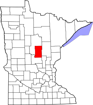
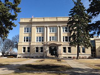
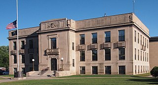
Brainerd is a city and the county seat of Crow Wing County, Minnesota, United States. Its population was 14,395 at the 2020 census. Brainerd straddles the Mississippi River several miles upstream from its confluence with the Crow Wing River, having been founded as a site for a railroad crossing above the confluence. Brainerd is the principal city of the Brainerd Micropolitan Area, a micropolitan area covering Cass and Crow Wing counties and with a combined population of 96,189 at the 2020 census. The city is well known for being the partial setting of the 1996 film Fargo.

<span class="mw-page-title-main">Crosby, Minnesota</span> City in Minnesota, United States

Crosby is a city in Crow Wing County, Minnesota, United States. The population was 2,386 at the 2010 census. It is part of the Brainerd Micropolitan Statistical Area. Crosby is adjacent to its twin city of Ironton, in the Cuyuna iron range.

<span class="mw-page-title-main">Crosslake, Minnesota</span> City in Minnesota, United States

Crosslake is a city in Crow Wing County, Minnesota, United States. The population was 2,141 at the 2010 census. It is part of the Brainerd Micropolitan Statistical Area.

<span class="mw-page-title-main">Cuyuna, Minnesota</span> City in Minnesota, United States

Cuyuna is a city in Crow Wing County, Minnesota, United States. The population was 332 at the 2010 census. It is part of the Brainerd Micropolitan Statistical Area.

<span class="mw-page-title-main">Fort Ripley, Minnesota</span> City in Minnesota, United States

Fort Ripley is a city in Crow Wing County, Minnesota, United States, near the confluence of the Mississippi and Nokasippi Rivers. The population was 69 at the 2010 census. It is part of the Brainerd Micropolitan Statistical Area.

<span class="mw-page-title-main">Nisswa, Minnesota</span> City in Minnesota, United States

Nisswa is a city in Crow Wing County, Minnesota, United States. The population was 1,971 at the 2010 census. Nisswa is part of the Brainerd Micropolitan Statistical Area, near Gull Lake.

<span class="mw-page-title-main">Trout Lake Township, Itasca County, Minnesota</span> Township in Minnesota, United States

Trout Lake Township is located in north central Minnesota in Itasca County, United States. It is bordered by the City of Coleraine to the west and north, City of Bovey on the north, an unorganized township on the east, and Blackberry Township to the south. Town government was adopted on March 6, 1894. The population was 1,056 at the 2020 census.

<span class="mw-page-title-main">Manganese, Minnesota</span> Ghost town in Minnesota, United States

Manganese is a ghost town and former mining community in the U.S. state of Minnesota that was inhabited between 1912 and 1960. It was built in Crow Wing County on the Cuyuna Iron Range in sections 23 and 28 of Wolford Township, about 2 miles (3 km) north of Trommald, Minnesota. After its formal dissolution, Manganese was absorbed by Wolford Township; the former town site is located between Coles Lake and Flynn Lake. First appearing in the U.S. Census of 1920 with an already dwindling population of 183, the village was abandoned by 1960.

<span class="mw-page-title-main">Brainerd micropolitan area</span> Micropolitan Statistical Area in Minnesota, United States

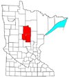
The Brainerd Micropolitan Statistical Area, as defined by the United States Census Bureau, is an area consisting of Cass County and Crow Wing County in Northern Minnesota, anchored by the city of Brainerd. As of July 1, 2022 estimate placed the population at 99,222.

References

  1. 1 2 "State & County QuickFacts". United States Census Bureau. Retrieved April 13, 2023.
  2. "Find a County". National Association of Counties. Archived from the original on May 31, 2011. Retrieved June 7, 2011.
  3. "Minnesota Place Names". Minnesota Historical Society. Archived from the original on October 27, 2014. Retrieved March 17, 2014.
  4. Ripley, George; Dana, Charles A., eds. (1879). "Crow Wing"  . The American Cyclopædia .
  5. Warren Upham (1920). Minnesota Geographic Names: Their Origin and Historic Significance. Minnesota Historical Society. p.  154.
  6. Nelson, Steven (2011).Savanna Soils of Minnesota. Minnesota: Self. pp. 53–56. ISBN   978-0-615-50320-2.
  7. "2010 Census Gazetteer Files". United States Census Bureau. August 22, 2012. Archived from the original on September 21, 2013. Retrieved October 6, 2014.
  8. 1 2 Crow Wing County MN Google Maps (accessed March 7, 2019)
  9. Minnesota Div of Natural Resources: Cuyuna Lakes State Trail (accessed March 7, 2019)
  10. "Burlington Northern (Brainerd/Baxter) Fact Sheet" Archived December 5, 2012, at the Wayback Machine , EPA, July 13, 2012
  11. "Annual Estimates of the Resident Population for Counties: April 1, 2020 to July 1, 2023" . Retrieved March 18, 2024.
  12. "U.S. Decennial Census". United States Census Bureau. Archived from the original on April 26, 2015. Retrieved October 6, 2014.
  13. "Historical Census Browser". University of Virginia Library. Archived from the original on June 23, 2018. Retrieved October 6, 2014.
  14. "Population of Counties by Decennial Census: 1900 to 1990". United States Census Bureau. Retrieved October 6, 2014.
  15. "Census 2000 PHC-T-4. Ranking Tables for Counties: 1990 and 2000" (PDF). United States Census Bureau. Archived (PDF) from the original on March 27, 2010. Retrieved October 6, 2014.
  16. "P2 HISPANIC OR LATINO, AND NOT HISPANIC OR LATINO BY RACE – 2020: DEC Redistricting Data (PL 94-171) – Crow Wing County, Minnesota".
  17. Leip, David. "Atlas of US Presidential Elections". uselectionatlas.org. Retrieved April 10, 2018.
  18. "County Board | Crow Wing County, MN – Official Website". crowwing.us. Retrieved April 25, 2023.
  19. "MN State Senate". www.senate.mn. Retrieved June 25, 2020.
  20. "Rep. Josh Heintzeman (10A) – Minnesota House of Representatives". www.house.leg.state.mn.us. Retrieved June 25, 2020.
  21. "Rep. Dale Lueck (10B) – Minnesota House of Representatives". www.house.leg.state.mn.us. Retrieved June 25, 2020.
  22. "Representative Pete Stauber". Representative Pete Stauber. Retrieved June 24, 2020.
  23. "U.S. Senator Amy Klobuchar". www.klobuchar.senate.gov. Retrieved June 24, 2020.
  24. "Home". Senator Tina Smith. Retrieved June 24, 2020.
  25. "2020 CENSUS - SCHOOL DISTRICT REFERENCE MAP: Crow Wing County, MN" (PDF). United States Census Bureau. Archived (PDF) from the original on July 7, 2021. Retrieved July 22, 2022. - Text list

46°29′N94°04′W / 46.49°N 94.07°W / 46.49; -94.07