Red Lake County, Minnesota

Last updated

Red Lake County
Red Lake County Courthouse.jpg
The Red Lake County Courthouse in Red Lake Falls in 2007
Map of Minnesota highlighting Red Lake County.svg
Location within the U.S. state of Minnesota
Minnesota in United States.svg
Minnesota's location within the U.S.
Coordinates: 47°53′N96°06′W / 47.88°N 96.1°W / 47.88; -96.1
CountryFlag of the United States.svg United States
StateFlag of Minnesota.svg  Minnesota
FoundedDecember 24, 1896
Named for Red Lake River
Seat Red Lake Falls
Largest cityRed Lake Falls
Area
  Total432 sq mi (1,120 km2)
  Land432 sq mi (1,120 km2)
  Water0.09 sq mi (0.2 km2)  0.02%
Population
 (2020)
  Total3,935
  Estimate 
(2023)
3,911 Decrease2.svg
  Density9.1/sq mi (3.5/km2)
Time zone UTC−6 (Central)
  Summer (DST) UTC−5 (CDT)
Congressional district 7th
Website www.co.red-lake.mn.us

Red Lake County is a county in the Northwestern part of the U.S. state of Minnesota. As of the 2020 census, the population was 3,935, [1] making it the third-least populous county in Minnesota. Its county seat is Red Lake Falls. [2]

Contents

History

Red Lake County was formed on December 24, 1896 [3] from sections of Polk County. It was named for the Red Lake River. Its designated county seat was Red Lake Falls, which had been incorporated (as a village) in 1881. [4]

The county has two sites on the National Register of Historic Places: the courthouse and Clearwater Evangelical Lutheran Church.

Geography

The Red Lake River flows southward into the county from Pennington County. It is joined near Red Lake Falls by the Clearwater River; the combined flow (still known as the Red Lake River) flows southwestward to Huot, where it is augmented by the Black River, which drains the northwestern part of the county. The Red Lake River then flows southwestward into Polk County. The county terrain consists of low rolling hills, etched by drainages and gullies. The area is devoted to agriculture. [5] The county terrain slopes to the west, with its highest elevation on its southeastern corner, at 1,201 ft (366 m) ASL. [6] The county has a total area of 432 square miles (1,120 km2), of which 432 square miles (1,120 km2) is land and 0.09 square miles (0.23 km2) (0.02%) is water. [7]

Despite its name, Red Lake County contains only one named lake: Moran Lake, near Huot. [8]

Red Lake County is the only landlocked county in the United States (excluding those on international borders) to border exactly two other counties. [9]

Soils of Red Lake County Red Lake Co Pie Chart No Text Version.pdf
Soils of Red Lake County

Major highways

Adjacent counties

Protected areas [5]

Demographics

Historical population
CensusPop.Note
1900 12,195
1910 6,564−46.2%
1920 7,26310.6%
1930 6,887−5.2%
1940 7,4137.6%
1950 6,806−8.2%
1960 5,830−14.3%
1970 5,388−7.6%
1980 5,4711.5%
1990 4,525−17.3%
2000 4,299−5.0%
2010 4,089−4.9%
2020 3,935−3.8%
2023 (est.)3,911 [11] −0.6%
U.S. Decennial Census [12]
1790-1960 [13] 1900-1990 [14]
1990-2000 [15] 2010-2020 [1]

2020 Census

Red Lake County Racial Composition [16]
RaceNum.Perc.
White (NH)3,62592.12%
Black or African American (NH)150.4%
Native American (NH)571.5%
Asian (NH)50.13%
Pacific Islander (NH)30.07%
Other/Mixed (NH)1273.23%
Hispanic or Latino 1032.62%

2000 census

2022 US Census population pyramid for Red Lake County, from ACS 5-year estimates RedLakeCountyMn2022PopPyr.png
2022 US Census population pyramid for Red Lake County, from ACS 5-year estimates

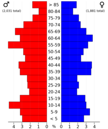
As of the census of 2000, there were 4,299 people, 1,727 households, and 1,131 families in the county. The population density was 9.95/sq mi (3.84/km2). There were 1,883 housing units at an average density of 4.36/sq mi (1.68/km2). The racial makeup of the county was 97.44% White, 0.19% Black or African American, 1.84% Native American, 0.07% Asian, 0.12% from other races, and 0.35% from two or more races. 0.30% of the population were Hispanic or Latino of any race. 31.9% were of Norwegian, 25.0% German, 16.7% French and 6.3% French Canadian ancestry.

There were 1,727 households, out of which 30.70% had children under the age of 18 living with them, 55.40% were married couples living together, 6.80% had a female householder with no husband present, and 34.50% were non-families. 30.50% of all households were made up of individuals, and 15.50% had someone living alone who was 65 years of age or older. The average household size was 2.39 and the average family size was 3.02.

The county population contained 25.50% under the age of 18, 7.50% from 18 to 24, 24.70% from 25 to 44, 23.20% from 45 to 64, and 19.10% who were 65 years of age or older. The median age was 40 years. For every 100 females there were 100.80 males. For every 100 females age 18 and over, there were 99.90 males.

The median income for a household in the county was $32,052, and the median income for a family was $40,275. Males had a median income of $28,494 versus $20,363 for females. The per capita income for the county was $15,372. About 8.40% of families and 10.80% of the population were below the poverty line, including 11.50% of those under age 18 and 13.10% of those age 65 or over.

Communities

Cities

Unincorporated communities

Townships

Government and politics

Red Lake County was formerly solidly Democratic, voting for that party's presidential nominee in all elections from 1928 until 1996, although since 2000 it has generally voted Republican, with the exception of its support for Barack Obama in 2008.

United States presidential election results for Red Lake County, Minnesota [17]
Year Republican Democratic Third party
No.%No.%No.%
2020 1,45466.21%69131.47%512.32%
2016 1,14160.66%54028.71%20010.63%
2012 97849.52%92846.99%693.49%
2008 98344.87%1,12051.12%884.02%
2004 1,16453.47%96344.24%502.30%
2000 1,09052.15%83039.71%1708.13%
1996 69533.00%1,05350.00%35817.00%
1992 69131.39%1,02046.34%49022.26%
1988 91842.21%1,22956.51%281.29%
1984 1,18447.49%1,29451.91%150.60%
1980 1,22345.18%1,31848.69%1666.13%
1976 73728.35%1,74867.23%1154.42%
1972 1,05241.40%1,40955.45%803.15%
1968 71830.97%1,46763.29%1335.74%
1964 57323.39%1,86175.96%160.65%
1960 67926.64%1,86573.17%50.20%
1956 78233.35%1,55566.31%80.34%
1952 1,03441.51%1,43157.45%261.04%
1948 59223.99%1,77171.76%1054.25%
1944 75731.36%1,64268.02%150.62%
1940 87630.05%2,02369.40%160.55%
1936 48718.36%2,05777.53%1094.11%
1932 35114.99%1,89380.86%974.14%
1928 71231.56%1,50766.80%371.64%
1924 64335.19%21311.66%97153.15%
1920 1,30862.37%55826.61%23111.02%
1916 46337.70%69456.51%715.78%
1912 25927.88%37440.26%29631.86%
1908 1,42853.01%85631.77%41015.22%
1904 1,43068.00%39918.97%27413.03%
1900 82339.10%1,16555.34%1175.56%
County Board of Commissioners [18]
PositionNameDistrict
CommissionerAnthony "Chuck" FlageDistrict 1
Commissioner and ChairpersonRon WeissDistrict 2
CommissionerDelane "John" DudychaDistrict 3
CommissionerAllen RemickDistrict 4
CommissionerCharles SimpsonDistrict 5
State Legislature (2023-2025)
PositionNameAffiliationDistrict
Senate Mark Johnson [19] Republican District 1
House of Representatives Deb Kiel [20] Republican District 1B
U.S Congress (2023-2025)
PositionNameAffiliationDistrict
House of Representatives Michelle Fischbach Republican 7th
Senate Amy Klobuchar [21] Democrat N/A
Senate Tina Smith [22] Democrat N/A

Media attention

The county received mention in the media when a Washington Post reporter, Christopher Ingraham, wrote a story calling Red Lake County "the absolute worst place to live in America" in a ranking of US counties by "scenery and climate". [23] After vigorous objections from local and state inhabitants and legislators, [24] Ingraham subsequently visited the county and not only reversed his position but later moved there with his family and wrote a book about his experience. [25] [26] [27] [28] [29] [30]

See also

Footnotes

  1. 1 2 "State & County QuickFacts". United States Census Bureau. Retrieved April 19, 2023.
  2. "Find a County". National Association of Counties. Retrieved June 7, 2011.
  3. "Minnesota Place Names". Minnesota Historical Society. Archived from the original on June 20, 2012. Retrieved March 19, 2014.
  4. Upham, Warren (1920). Minnesota Geographic Names: Their Origin and Historic Significance. Minnesota Historical Society. p.  445.
  5. 1 2 3 Red Lake County MN Google Maps (accessed April 7, 2019)
  6. "Find an Altitude/Red Lake County MN" Google Maps (accessed April 7, 2019)
  7. "2010 Census Gazetteer Files". United States Census Bureau. August 22, 2012. Archived from the original on September 21, 2013. Retrieved October 24, 2014.
  8. "LakeFinder - Lake Search - Minnesota DNR - MN Department of Natural Resources". www.dnr.state.mn.us. Retrieved October 10, 2018.
  9. "Fewest County Borders – Part III: Red Lake Co., MN - Twelve Mile Circle". www.howderfamily.com. November 15, 2007. Retrieved October 10, 2018.
  10. Nelson, Steven (2011). Savanna Soils of Minnesota. Minnesota:Self. pp. 57-60. ISBN   978-0-615-50320-2.
  11. "Annual Estimates of the Resident Population for Counties: April 1, 2020 to July 1, 2023" . Retrieved March 18, 2024.
  12. "US Decennial Census". United States Census Bureau. Retrieved October 24, 2014.
  13. "Historical Census Browser". University of Virginia Library. Retrieved October 24, 2014.
  14. "Population of Counties by Decennial Census: 1900 to 1990". United States Census Bureau. Retrieved October 24, 2014.
  15. "Census 2000 PHC-T-4. Ranking Tables for Counties: 1990 and 2000" (PDF). United States Census Bureau. Archived (PDF) from the original on March 27, 2010. Retrieved October 24, 2014.
  16. "P2 HISPANIC OR LATINO, AND NOT HISPANIC OR LATINO BY RACE – 2020: DEC Redistricting Data (PL 94-171) – Red Lake County, Minnesota".
  17. Leip, David. "Atlas of US Presidential Elections". uselectionatlas.org. Retrieved October 10, 2018.
  18. "Board of Commissioners | Polk County, MN". www.co.polk.mn.us. Retrieved June 25, 2020.
  19. "MN State Senate". www.senate.mn. Retrieved June 25, 2020.
  20. "Rep. Debra Kiel (01B) - Minnesota House of Representatives". www.house.leg.state.mn.us. Retrieved June 25, 2020.
  21. "U.S. Senator Amy Klobuchar". www.klobuchar.senate.gov. Retrieved June 24, 2020.
  22. "Home". Senator Tina Smith. Retrieved June 24, 2020.
  23. Ingraham, Christopher (August 17, 2015). "Every county in America, ranked by scenery and climate". The Washington Post. Retrieved January 3, 2020.
  24. Ingraham, Christopher (August 19, 2015). "Thick coats, thin skins: Why Minnesotans were outraged by a recent Washington Post report". The Washington Post. Retrieved January 3, 2020.
  25. Martin, Rachael (September 11, 2019). "A Throwaway Line Led 'Washington Post' Reporter To Call Rural Midwest His New Home". NPR. Retrieved January 3, 2020.
  26. Jackson, Sharyon (September 13, 2019). "Washington Post reporter dissed Minnesota county, then moved there. Now he won't leave". The Star Tribune. Retrieved January 3, 2020.
  27. Avirgan, Jody (March 25, 2016). "He Called It America's Worst Place To Live. Now He's Moving There". FiveThrityEight. Retrieved January 3, 2020.
  28. Jackson, Sharyon (April 25, 2017). "Washington Post reporter who insulted Red Lake Falls, Minn., now making his home there". The Chicago Tribune. Retrieved January 3, 2020.
  29. "Reporter who called Minnesota county the worst place in America learning to call it home". CBC News. May 22, 2017. Retrieved January 3, 2020.
  30. "Red Lake County". CBS News. March 31, 2017. Retrieved January 3, 2020.

Further reading

47°53′N96°06′W / 47.88°N 96.10°W / 47.88; -96.10

Related Research Articles

<span class="mw-page-title-main">Yellow Medicine County, Minnesota</span> County in Minnesota, United States

Yellow Medicine County is a county in the southwestern part of the U.S. state of Minnesota. Its eastern border is formed by the Minnesota River. As of the 2020 census, the population was 9,528. Its county seat is Granite Falls.

<span class="mw-page-title-main">Washington County, Minnesota</span> County in Minnesota, United States

Washington County is a county in the U.S. state of Minnesota. As of the 2020 census, the population was 267,568, making it the fifth-most populous county in Minnesota. Its county seat is Stillwater. The largest city in the county is Woodbury, the eighth-largest city in Minnesota and the fourth-largest Twin Cities suburb.

<span class="mw-page-title-main">Traverse County, Minnesota</span> County in Minnesota, United States

Traverse County is a county in the U.S. state of Minnesota. As of the 2020 census, the population was 3,360, making it the least-populous county in Minnesota. Its county seat is Wheaton. The county was founded in 1862 and organized in 1881.

<span class="mw-page-title-main">Roseau County, Minnesota</span> County in Minnesota, United States

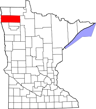
Roseau County is a county in the northwestern part of the U.S. state of Minnesota, along the Canada–US border. As of the 2020 census, the population was 15,331. Its county seat is Roseau. Roseau County borders the Canadian province of Manitoba.

<span class="mw-page-title-main">Rice County, Minnesota</span> County in Minnesota, United States

Rice County is a county located in the south central portion of the U.S. state of Minnesota. As of the 2020 census, the population was 67,097. Its county seat is Faribault.

<span class="mw-page-title-main">Renville County, Minnesota</span> County in Minnesota, United States

Renville County is a county in the U.S. state of Minnesota. As of the 2020 census the population was 14,723. Its county seat is Olivia.

<span class="mw-page-title-main">Polk County, Minnesota</span> County in Minnesota, United States

Polk County is a county in the northwestern part of the U.S. state of Minnesota. The population was 31,192 at the 2020 census. Its county seat is Crookston, and the largest community is East Grand Forks.

<span class="mw-page-title-main">Pennington County, Minnesota</span> County in Minnesota, United States

Pennington County is a county in the northwestern part of the U.S. state of Minnesota. As of the 2020 census, the population was 13,992. Its county seat is Thief River Falls.

<span class="mw-page-title-main">Norman County, Minnesota</span> County in Minnesota, United States

Norman County is a county in the northwestern part of the U.S. state of Minnesota. As of the 2020 census, the population was 6,441. Its county seat is Ada. The county is in Minnesota's Red River Valley region.

<span class="mw-page-title-main">Marshall County, Minnesota</span> County in Minnesota, United States

Marshall County is a county in the northwestern part of the U.S. state of Minnesota. As of the 2020 census, the population was 9,040. Its county seat is Warren.

<span class="mw-page-title-main">Mahnomen County, Minnesota</span> County in Minnesota, United States

Mahnomen County is a county in the U.S. state of Minnesota. As of the 2020 census, the population was 5,411. Its county seat is Mahnomen.

<span class="mw-page-title-main">Goodhue County, Minnesota</span> County in Minnesota, United States

Goodhue County is a county in the U.S. state of Minnesota. As of the 2020 census, the population was 47,582. Its county seat is Red Wing. Nearly all of Prairie Island Indian Community is within the county.

<span class="mw-page-title-main">Douglas County, Minnesota</span> County in Minnesota, United States

Douglas County is a county in the U.S. state of Minnesota. As of the 2020 census, the population was 39,006. Its county seat is Alexandria.

<span class="mw-page-title-main">Crow Wing County, Minnesota</span> County in Minnesota, United States

Crow Wing County is a county in the East Central part of the U.S. state of Minnesota. As of the 2020 census, the population was 66,123. Its county seat is Brainerd. The county was formed in 1857, and was organized in 1870.

<span class="mw-page-title-main">Clearwater County, Minnesota</span> County in Minnesota, United States

Clearwater County is a county in the northwestern part of the U.S. state of Minnesota. As of the 2020 census, the population was 8,524. Its county seat is Bagley.

<span class="mw-page-title-main">Chippewa County, Minnesota</span> County in Minnesota, United States

Chippewa County is a county in the U.S. state of Minnesota. As of the 2020 census, the population was 12,598. Its county seat is Montevideo. The county was formed in 1862, and was organized in 1868.

<span class="mw-page-title-main">Carlton County, Minnesota</span> County in Minnesota, United States

Carlton County is a county in the State of Minnesota, formed in 1857. As of the 2020 census, the population was 36,207. Its county seat is Carlton. Part of the Fond du Lac Indian Reservation lies in northeastern Carlton County.

<span class="mw-page-title-main">Aitkin County, Minnesota</span> County in Minnesota, United States

Aitkin County is a county in the U.S. state of Minnesota. As of the 2020 census, the population was 15,697. Its county seat is Aitkin. Part of the Mille Lacs Indian Reservation is in the county. The county was created in 1857 and organized in 1871.

Badger Township is a township in Polk County, Minnesota, United States. It is part of the Grand Forks-ND-MN Metropolitan Statistical Area. Under the United States Public Land Survey System it is a survey township identified as Township 149 North, Range 42 West, Fifth Principal Meridian. The population was 166 at the 2000 census.

<span class="mw-page-title-main">Red Lake Falls, Minnesota</span> City in Minnesota, United States

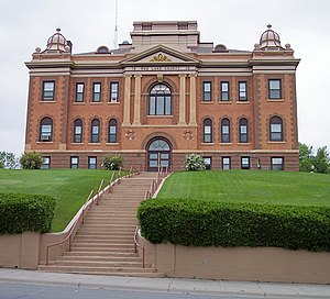
Red Lake Falls is a city and the county seat of Red Lake County, Minnesota, United States. The population was 1,339 at the 2020 census. It is the county seat of Red Lake County. The city lies in the middle of Red Lake Falls Township, from which it was separated when incorporated as a village in 1881. Its status was raised to that of a city in 1898.