A trail, also known as a path or track, is an unpaved lane or a small paved road not intended for usage by motorized vehicles, usually passing through a natural area. In the United Kingdom and the Republic of Ireland, a path or footpath is the preferred term for a pedestrian or hiking trail. The term is also applied in North America to accompanying routes along rivers, and sometimes to highways. In the US, the term was historically used for a route into or through wild territory used by explorers and migrants. In the United States, "trace" is a synonym for trail, as in Natchez Trace.

The Little Miami Scenic Trail is the fourth longest paved trail in the United States, running 78.1 miles (125.7 km) through five southwestern counties in the state of Ohio. The multi-use rail trail sees heavy recreational use by hikers and bicyclists, as well as the occasional horseback rider. Over 700,000 people made use of the trail in 2014.

Since the advent of the bicycle in the 1860s, Chicago has been distinguished as one of the premier cycling locations in the United States, with such public cycling destinations as Grant Park, Burnham Park and the Chicago Park District's Lakefront Trail.

Cedar Lake is a lake in Minneapolis, Minnesota, United States, and part of the city's Chain of Lakes. It is located on the west side of the city, north of Bde Maka Ska and west of Lake of the Isles. The lake is surrounded by parkland, with some easements having been made to private homeowners on the southeast side; it is the only lake in the city with private shoreline. The south and west sides border the Cedar-Isles-Dean neighborhood, while the east shore flanks the Kenwood residential area. On the north is the Cedar Lake Trail and the BNSF Railway, and the south Bryn Mawr neighborhood. Cedar Lake has an area of 169 acres (0.68 km2) and a maximum depth of 51 feet (16 m). The Minneapolis Park and Recreation Board manages the lake and parkland around the lake.

Cedar Lake Trail is a 4.3-mile (6.9 km), shared-use path in the U.S. state of Minnesota, from downtown Minneapolis to the neighboring suburb of St. Louis Park. The trail begins at its eastern trailhead in downtown Minneapolis (44°59′11″N93°16′01″W) and continues west to Minnesota State Highway 100 in St. Louis Park (44°57′43″N93°20′36″W). At the trail's west end, a paved path continues for another 4.2 miles (6.8 km) through St. Louis Park to Hopkins under the former name of Hutchinson Spur Trail, but known as North Cedar Lake Regional Trail since 2009. In 2019, large portions of the Cedar Lake Trail were closed due to construction of the Southwest LRT extension with expected reopening in 2021 or 2022.

A bicycle boulevard, sometimes referred to as a neighborhood greenway, neighborway, neighborhood bikeway or neighborhood byway is a type of bikeway composed of a low-speed street which has been "optimized" for bicycle traffic. Bicycle boulevards discourage cut-through motor-vehicle traffic but allow local motor-vehicle traffic. They are designed to give priority to bicyclists as through-going traffic. They are intended as a low-cost, politically popular way to create a connected network of streets with good bicyclist comfort and/or safety.
The United States Bicycle Route System is the national cycling route network of the United States. It consists of interstate long-distance cycling routes that use multiple types of bicycling infrastructure, including off-road paths, bicycle lanes, and low-traffic roads. As with the complementary United States Numbered Highways system for motorists, each U.S. Bicycle Route is maintained by state and local governments. The USBRS is intended to eventually traverse the entire country, like the Dutch National Cycle Routes and the United Kingdom's National Cycle Network, yet at a scale similar to the EuroVelo network that spans Europe.
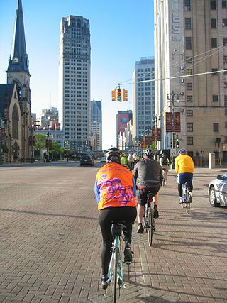
Detroit is a popular city for cycling. It is flat with an extensive road network with a number of recreational and competitive opportunities and is, according to cycling advocate David Byrne, one of the top eight biking cities in the world. The city has invested in greenways and bike lanes and other bicycle-friendly infrastructure. Bike rental is available from the riverfront and tours of the city's architecture can be booked.
U.S. Bicycle Route 20 (USBR 20) is a U.S. Numbered Bicycle Route that is planned to run from the Oregon Coast to Marine City, Michigan. As of 2021, sections of the route in Washington state and Michigan have been approved by the American Association of State Highway and Transportation Officials (AASHTO), comprising 387 miles (623 km).

The Kenilworth Trail is a paved bicycle trail in Minneapolis, Minnesota, United States. It runs nearly 1.5 miles (2.4 km) and acts as a connector between the Cedar Lake Trail in the north and the Midtown Greenway in the south. Like the Cedar Lake Trail, most of the route is composed of a triple-divided cycleway/pedway with a pair of one-way paths for bicycles and another path for pedestrians. On some maps, a southern segment of the Kenilworth Trail is called the Burnham Trail. The trail corridor has been considered the most highly trafficked in the Minneapolis park system.

Bicycle use in Portland, Oregon has been growing rapidly, having nearly tripled since 2001; for example, bicycle traffic on four of the Willamette River bridges has increased from 2,855 before 1992 to over 16,000 in 2008, partly due to improved facilities. The Portland Bureau of Transportation says 6% of commuters bike to work in Portland, the highest proportion of any major U.S. city and about 10 times the national average.
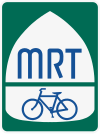
The Mississippi River Trail is a designated bicycle and pedestrian trail that traverses the shores of the Mississippi River in the United States. The trail extends from the headwaters at Lake Itasca in Minnesota to near the mouth of the river in Venice, Louisiana. Much of the trail’s 3,000 miles (4,800 km) follows roadways used by motor vehicles, although some of the route is on multi-use trails. The segment in Minnesota has been designated as U.S. Bicycle Route 45, part of the U.S. Bicycle Route System.
U.S. Bicycle Route 10 (USBR 10) is a United States Bicycle Route that is planned to follow U.S. Route 2 across the northern United States, beginning in Anacortes, Washington and ending in St. Ignace, Michigan. As of 2015, only 666 miles (1,072 km) of the planned corridor is designated, within the states of Washington, Idaho, and Michigan.

The Hank Aaron State Trail is a 15.2-mile (24.5 km) rail trail in Milwaukee County, Wisconsin. The trail is named after former Milwaukee Braves and Milwaukee Brewers right fielder Hank Aaron and is built on a former roadbed of the Milwaukee Road. As of 2023, according to the Wisconsin Department of Natural Resources, approximately 200,000 people use the trail annually.

A bicycle highway, also known as a cycling superhighway, fast cycle route or bike freeway, is an informal name for a bicycle path that is meant for long-distance traffic. There is no official definition of a bicycle highway. The characteristics of a cycle motorway mentioned by authorities and traffic experts include an absence of single-level intersections with motorized traffic, a better road surface and the absence of traffic lights. Bicycle highways are mentioned in connection with traffic jam. Owing to higher average speeds than normal cycling infrastructure, they provide an alternative to the car in commuter traffic. Often a cycle motorway follows the route of a railway or other linear infrastructure.
U.S. Bicycle Route 66 (USBR 66) is a United States Bicycle Route that follows the former U.S. Route 66 (US 66) across the United States. The first section of the route, spanning 358 miles (576 km) between Baxter Springs, Kansas, and St. Louis, Missouri, was designated as USBR 66 in 2018. A second section was designated in 2021 between Santa Monica, California, and the Arizona state line near Needles, California. The Oklahoma section was designated in 2022. The rest of the route remains proposed but not yet designated.

Minnehaha Trail is a 1.5-mile (2.4 km) paved, multi-use trail in Minneapolis, Minnesota, United States, that connects Minnehaha Regional Park and Fort Snelling State Park – two of the most popular recreation destinations in the Twin Cities metro area. The trail is considered a segment of a longer, loosely connected bicycle route system along the Mississippi River. Users of Minnehaha Trail traverse under a forest canopy. The trail received local recognition for its natural beauty, but it was criticized for its worn pavement and lack of signage.

Minneapolis is often considered one of the top biking and walking cities in the United States due to its vast network of trails and dedicated pedestrian areas. In 2020, Walk Score rated Minneapolis as 13th highest among cities over 200,000 people. Some bicycling ratings list Minneapolis at the top of all United States cities, while others list Minneapolis in the top ten. There are over 80 miles (130 km) of paved, protected pathways in Minneapolis for use as transportation and recreation. The city's Grand Rounds National Scenic Byway parkway system accounts for the vast majority of the city's shared-use paths at approximately 50 miles (80 km) of dedicated biking and walking areas. By 2008, other city, county, and park board areas accounted for approximately 30 miles (48 km) of additional trails, for a city-wide total of approximately 80 miles (130 km) of protected pathways. The network of shared biking and walking paths continued to grow into the late 2010s with the additions of the Hiawatha LRT Trail gap remediation, Min Hi Line pilot projects, and Samatar Crossing. The city also features several natural-surface hiking trails, mountain-biking paths, groomed cross-country ski trails in winter, and other pedestrian walkways.