External links
Coordinates: 47°29′44″N92°41′30″W / 47.49556°N 92.69167°W
| Central/Metro | ||
|---|---|---|
| Northeast | ||
| Northwest | ||
| Southeast | ||
| Southwest | ||
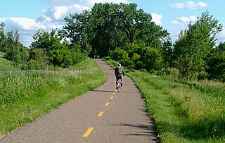
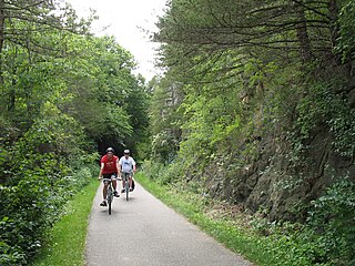
The Mesabi Trail is a 132 mile paved bicycle trail running from Grand Rapids, Minnesota to Ely, Minnesota. As of 2022, two sections remain to be completed: McKinley to Biwabik, and the seven miles south of Tower. Trail construction is expected to be finished by 2024. [1] The trail goes through the many small towns along it, such as Marble, Keewatin, Hibbing, Mountain Iron, Virginia, and Gilbert. Much of the trail runs along abandoned railroad grade.
Since 2005, the Mesabi Trail has hosted a long bike ride every year in mid-August. Each stop (usually at a town or at intervals between towns) has fruit, water, granola, and other snacks. In Buhl, there is ice cream. The refreshments are free, as is the food at the ending destination, but there is a fee to ride in this event. To accommodate riders of different abilities, the ride includes multiple official starting points; while the full route may be 50 to 70 miles, intermediate starting places along the route may be as close as 8 or 10 miles from the end.
| Year | Start | End | Max Length |
|---|---|---|---|
| 2005 | Biwabik (Giant's Ridge Ski Resort) | Chisholm (Ironworld Discovery Center) | 50 miles |
| 2006 | Biwabik (Giant's Ridge Ski Resort) | Hibbing (Bennet Park) | 57 miles |
| 2007 | Marble | Virginia (Olcott Park) | 51 miles |
| 2008 | Marble | Virginia (Olcott Park) | 51 miles |
| 2009 | Grand Rapids (Itasca County Fairgrounds) | Chisholm (Museum of Mining) | 50 miles |
| 2010 | Biwabik (Giant's Ridge Ski Resort) | Hibbing (Bennet Park) | 50 miles |
| 2011 | Chisholm (Minnesota Discover Center) | Grand Rapids (Itasca County Fairgrounds) | 48 miles |
| 2012 | Grand Rapids (Itasca County Fairgrounds) | Virginia (Olcott Park) | 64 miles |
| 2013 | ? | ? | ? |
| 2014 | Fayal Township (Township Hall) | Coleraine (Longyear Park) | 69 miles |
Along the Mesabi Trail there are signs that establish the history along it. Most of the signs notice certain areas as important to the Mesabi Range's early mining economy.
Coordinates: 47°29′44″N92°41′30″W / 47.49556°N 92.69167°W
| Central/Metro | ||
|---|---|---|
| Northeast | ||
| Northwest | ||
| Southeast | ||
| Southwest | ||

Townsend is a town in New Castle County, Delaware, United States. The population was 2,049 at the 2010 census, an increase of 492.2% from 2000. The center of population of Delaware is located in Townsend.

Biwabik is a city in Saint Louis County, Minnesota, United States. The population was 961 at the 2020 census.

Virginia is a city in St. Louis County, Minnesota, United States, on the Mesabi Iron Range. With an economy heavily reliant on large-scale iron ore mining, Virginia is considered the commercial center of the Mesabi Range. The population was 8,423 at the 2020 census. Virginia is just south of the Superior National Forest and is about 100 miles (160 km) south of the Canada–United States border at International Falls, Minnesota and 55 miles (89 km) northwest of Duluth, Minnesota. Virginia is a part of the Duluth metropolitan area and U.S. Highway 53 runs through town.

The Great Northern Railway was an American Class I railroad. Running from Saint Paul, Minnesota, to Seattle, Washington, it was the creation of 19th-century railroad entrepreneur James J. Hill and was developed from the Saint Paul & Pacific Railroad. The Great Northern's route was the northernmost transcontinental railroad route in the U.S.

The Mesabi Iron Range is a mining district in northeastern Minnesota following an elongate trend containing large deposits of iron ore. It is the largest of four major iron ranges in the region collectively known as the Iron Range of Minnesota. First described in 1866, it is the chief iron ore mining district in the United States. The district is located largely in Itasca and Saint Louis counties. It has been extensively worked since 1892, and has seen a transition from high-grade direct shipping ores through gravity concentrates to the current industry exclusively producing iron ore (taconite) pellets. Production has been dominantly controlled by vertically integrated steelmakers since 1901, and therefore is dictated largely by US ironmaking capacity and demand.

The North Country National Scenic Trail, generally known as the North Country Trail or simply the NCT, is a footpath stretching over 4,800 miles (7,700 km) from Middlebury in central Vermont to Lake Sakakawea State Park in central North Dakota in the United States; connecting both the Long Trail and the Appalachian Trail with the Lewis and Clark Trail. Passing through the eight states of Vermont, New York, Pennsylvania, Ohio, Michigan, Wisconsin, Minnesota and North Dakota, it is the longest of the eleven National Scenic Trails authorized by Congress. As of early 2019, 3,129 miles (5,036 km) of the trail is in place.
The term Iron Range refers collectively or individually to a number of elongated iron-ore mining districts around Lake Superior in the United States and Canada. Despite the word "range", the iron ranges are not mountain chains, but outcrops of Precambrian sedimentary formations containing high percentages of iron. These cherty iron ore deposits are Precambrian in age for the Vermilion Range and middle Precambrian in age for the Mesabi and Cuyuna ranges, all in Minnesota. The Gogebic Range in Wisconsin and the Marquette Iron Range and Menominee Range in Michigan have similar characteristics and are of similar age. Natural ores and concentrates were produced from 1848 until the mid 1950s, when taconites and jaspers were concentrated and pelletized, and started to become the major source of iron production.

The Arrowhead Region is located in the northeastern part of the U.S. state of Minnesota, so called because of its pointed shape. The predominantly rural region encompasses 10,635.26 square miles (27,545.2 km2) of land area and includes Carlton, Cook, Lake and Saint Louis counties. Its population at the 2000 census was 248,425 residents. The region is loosely defined, and Aitkin, Itasca, and Koochiching counties are sometimes considered as part of the region, increasing the land area to 18,221.97 square miles (47,194.7 km2) and the population to 322,073 residents. Primary industries in the region include tourism and iron mining.
The Vermilion Range exists between Tower, Minnesota and Ely, Minnesota, and contains significant deposits of iron ore. Together with the Mesabi and Cuyuna Ranges, these three constitute the Iron Ranges of northern Minnesota. While the Mesabi Range had iron ore close enough to the surface to enable pit mining, mines had to be dug deep underground to reach the ore of the Vermilion and Cuyuna ranges. The Soudan mine was nearly 1/2 mile underground and required blasting of Precambrian sedimentary bedrock.

U.S. Highway 169 (U.S. 169) is a major north–south highway in the U.S. state of Minnesota, connecting the Minnesota River valley with the Twin Cities and the Iron Range. Much of the route is built to expressway or freeway standards.
The Gateway State Trail is a multi-use recreational rail trail in the U.S. state of Minnesota, running 18 miles (29 km) from Saint Paul to Pine Point Regional Park in Stillwater. It runs through urban landscapes of eastern Saint Paul in Ramsey County and rural farmland and forests in Washington County. It was designated a National Recreation Trail in 2002.
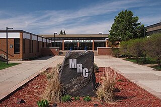
Minnesota North College – Mesabi Range Virginia, most recently known as Mesabi Range College (MRC) Virginia campus, which was formerly known as Mesabi Range Community and Technical College) is a public community college campus located in Virginia, Minnesota. In 2022, the board of trustees of the Minnesota State Colleges and Universities merged the college with several others into a single institution called Minnesota North College.
Root River State Trail and Harmony-Preston State Trail are a 60-mile (97 km) paved multi-use rail trail system in the driftless area of southeast Minnesota. The trail system consists of two main segments, the Root River segment, and Harmony-Preston Valley segment. The trails are used mainly for bicycling, hiking, and inline skating in the summer, and for cross country skiing in the winter. Much of the trail, especially the Root River segment, is built along a former Milwaukee Road railbed following the contours of the Root River valley. The trail was originally paved in the 1980s, and repaved by June 2008.

The Gitchi-Gami State Trail is a multi-use recreational trail in development along the North Shore of Lake Superior in Minnesota, USA. Planned to extend 88 miles (142 km) from Two Harbors to Grand Marais, the trail currently comprises five unconnected segments. The route will be situated primarily along state-owned right-of-way for Minnesota State Highway 61, with deviations for greater scenic diversity. "Gitchi-Gami" is an anglicization of the name for Lake Superior in the Ojibwe language.

The Heartland State Trail is a multi-use recreational rail trail in north-central Minnesota, USA. It runs 49 miles (79 km) between Park Rapids and Cass Lake, intersecting with the Paul Bunyan State Trail around Walker. The entire route is paved, with a parallel grass trackway along the southern half for horseback riding and mountain biking. The northern half of the trail has some parallel trackway for snowmobiles. A 4-mile (6.4 km) segment north of Walker traverses very hilly terrain to appeal to snowmobilers; other users can follow a marked alternate route on paved road shoulders.

The Mesabi Daily News was a daily newspaper published in Virginia, Minnesota. It had a Sunday circulation of 10,000. The Mesabi Daily News was one of the oldest surviving businesses in Virginia. It was located at 704 7th Ave South. As of 2018, the chief editor was Jerry Burnes and the Regional Operations/General Manager/Advertising Director was Chris Knight, a member of the Virginia Rotary Club, the Northern Club and the YMCA. In 2020, the paper was merged with the Hibbing Daily Tribune as the Mesabi Tribune.

Elcor is a ghost town, or more properly, an extinct town, in the U.S. state of Minnesota that was inhabited between 1897 and 1956. It was built on the Mesabi Iron Range near the city of Gilbert in St. Louis County. Elcor was its own unincorporated community before it was abandoned and was never a neighborhood proper of the city of Gilbert. Not rating a figure in the national census, the people of Elcor were only generally considered to be citizens of Gilbert. The area where Elcor was located was annexed by Gilbert when its existing city boundaries were expanded after 1969.
The Rouchleau Mine is an abandoned open-pit mine within the Mesabi Iron Range at Virginia, Minnesota, United States. The mine, located on the east side of the city, is roughly 3 miles (4.8 km) long and .5 miles (0.80 km) wide; its deepest point is 450 feet (140 m) below its surface, making it one of the deepest mines in the range. Named for Louis Rouchleau, who explored the area for its mining potential, the mine was initially created as a shaft mine. It was converted to a pit mine by the 1930s due to improvements in open-pit mining technology and increasingly unstable terrain which made shaft mining unsafe.

Winchell Trail is a five-mile (8 km) round trip, pedestrian-only trail in Minneapolis, Minnesota, United States, that runs along the west side of the Mississippi River between Franklin Avenue South and East 44th Street. Popular with bird watchers and naturalists, the rustic trail provides Upper Mississippi River gorge access and views. The trail is separate from the adjacent multi-use bicycle path, taking hikers past sandy beaches, an oak savanna restoration project, and the floodplain forest. The trail has multiple access points and the section from East 38th Street to East 44th Street is paved. Described as moderate and for all hiking skill levels, the out-and-back Winchell Trail has total elevation gain of 501 feet (153 m). Portions of the trail can be hiked in near solitude as its age and general destitute make it a widely forgotten place to explore.

Minnehaha Trail is a 1.5-mile (2.4 km) paved, multi-use trail in Minneapolis, Minnesota, United States, that connects Minnehaha Regional Park and Fort Snelling State Park – two of the most popular recreation destinations in the Twin Cities metro area. The trail is considered a segment of a longer, loosely connected bicycle route system along the Mississippi River. Users of Minnehaha Trail traverse under a forest canopy. The trail received local recognition for its natural beauty, but it was criticized for its worn pavement and lack of signage.