
The North Country National Scenic Trail, generally known as the North Country Trail or simply the NCT, is a footpath stretching over 4,800 miles (7,700 km) from Middlebury in central Vermont to Lake Sakakawea State Park in central North Dakota in the United States; connecting both the Long Trail and the Appalachian Trail with the Lewis and Clark Trail. Passing through the eight states of Vermont, New York, Pennsylvania, Ohio, Michigan, Wisconsin, Minnesota and North Dakota, it is the longest of the eleven National Scenic Trails authorized by Congress. As of early 2019, 3,129 miles (5,036 km) of the trail is in place.

Fort Snelling State Park is a state park of the U.S. state of Minnesota, at the confluence of the Mississippi and Minnesota rivers. For many centuries, the area of the modern park has been of importance to the Mdewakanton Dakota people who consider it the center of the earth. The state park, which opened in 1962, is named for the historic Fort Snelling, which dates from 1820. The fort structure is maintained and operated by the Minnesota Historical Society. The bulk of the state park preserves the bottomland forest, rivers, and backwater lakes below the river bluffs. Both the state and historic fort structure are part of the Mississippi National River and Recreation Area, a National Park Service site.

The Mountains-to-Sea State Trail (MST) is a long-distance trail for hiking and backpacking, that traverses North Carolina from the Great Smoky Mountains to the Outer Banks. The trail's western endpoint is at Clingman's Dome, where it connects to the Appalachian Trail in the Great Smoky Mountains National Park. Its eastern endpoint is in Jockey's Ridge State Park on the tallest sand dune on the east coast. The trail is envisioned as a scenic backbone of an interconnected trail system spanning the state. As such, the trail's route attempts to connect as many trail systems and natural scenic areas as practicable. A little over half of the trail is complete in multiple segments across the state.

The Cannon Valley Trail is a paved rail trail that follows the Cannon River in southeast Minnesota. The trail follows an abandoned Chicago Great Western Railway corridor for 20 miles (32 km) between Cannon Falls, Minnesota and Red Wing, Minnesota. In the spring, summer, and fall months, the trail is open to hiking, biking, and inline skating. In the winter months, the trail is groomed for cross-country skiing.

Three Rivers Park District is a special park district serving the suburban areas of the Twin Cities including suburban Hennepin, Carver, Dakota, Scott, and Ramsey counties. Three Rivers's mission is "To promote environmental stewardship through recreation and education in a natural resources-based park system." Three Rivers operates twenty parks and ten regional trails, with at least two more regional trails planned. Nearly seven million people visit Three Rivers facilities each year. It has over 27,000 acres (11,000 ha) of parks and trails.

Minnesota Valley State Recreation Area is a 5,490-acre (2,222 ha) unit of the Minnesota state park system in the United States. The park is not continuous but is composed of waysides, four of which are strung along the Minnesota River between Shakopee and Belle Plaine. The various waysides are interspersed with units of the Minnesota Valley National Wildlife Refuge, a part of the Mississippi National River and Recreation Area. Although the state recreation area is managed by the Minnesota Department of Natural Resources and the national wildlife refuge by the United States Fish and Wildlife Service, both agencies share a consistent signage to simplify visitation.
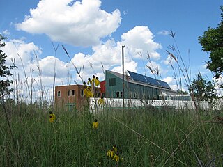
The Minnesota Valley National Wildlife Refuge is a 14,000-acre (5,666 ha) National Wildlife Refuge in eastern and central Minnesota. Located just south of the city of Minneapolis, it is one of fourteen Regional Priority Urban Wildlife Refuges in the nation. Many parts of the Refuge are near large establishments of the Twin Cities; the Bloomington Education and Visitor Center and two trailheads are located just blocks from the Mall of America, the Wilkie Unit is just east of Valleyfair and the Louisville Swamp Unit is just south of Minnesota Renaissance Festival.

The Oak Leaf Trail is a paved 108-mile (174 km) multi-use recreational trail which encircles Milwaukee County, Wisconsin. Clearly marked trail segments connect all of the major parks in the Milwaukee County Park System with a "ribbon of green."

U.S. Highway 169 (U.S. 169) is a major north–south highway in the U.S. state of Minnesota, connecting the Minnesota River valley with the Twin Cities and the Iron Range. Much of the route is built to expressway or freeway standards.
The Gateway State Trail is a multi-use recreational rail trail in the U.S. state of Minnesota, running 18 miles (29 km) from Saint Paul to Pine Point Regional Park in Stillwater. It runs through urban landscapes of eastern Saint Paul in Ramsey County and rural farmland and forests in Washington County. It was designated a National Recreation Trail in 2002.

The Rio Grande Trail is a proposed long distance trail along the Rio Grande in the U.S. state of New Mexico. The river extends over 1,800 total miles, some 700 miles (1,100 km) of which pass through the heart of New Mexico. It is the state's primary drainage feature and most valuable natural and cultural resource. The river and its bosque provide a wide variety of recreation, including hunting and fishing, birdwatching, river rafting, hiking, biking, and horseback riding. The river also flows through or beside numerous spectacular and geologically interesting landforms, the result of extensive volcanism and erosion of the valley within the Rio Grande Rift. Although some trail advocates would like to see the trail extended the full distance through New Mexico, from the Colorado border to the United States–Mexico border, the portion proposed for initial development extends 300 miles (480 km), from Bernalillo south to Las Cruces.

U.S. Highway 212 (US 212) within the state of Minnesota travels from the South Dakota state line in the west, crosses the southwestern part of the state, to the Minneapolis–Saint Paul metropolitan area in the east and end at its interchange with US 169 and State Highway 62 (MN 62) in the Minneapolis suburb of Edina. US 212 in Minnesota has an official length of 161.8 miles (260.4 km). It is an urban freeway within the Minneapolis–Saint Paul area and is mostly a two-lane rural road elsewhere in the state.
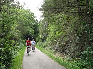
Root River State Trail and Harmony-Preston State Trail are a 60-mile (97 km) paved multi-use rail trail system in the driftless area of southeast Minnesota. The trail system consists of two main segments, the Root River segment, and Harmony-Preston Valley segment. The trails are used mainly for bicycling, hiking, and inline skating in the summer, and for cross country skiing in the winter. Much of the trail, especially the Root River segment, is built along a former Milwaukee Road railbed following the contours of the Root River valley. The trail was originally paved in the 1980s, and repaved by June 2008.
The Mankato Subdivision or Mankato Sub is a railway line operated by the Union Pacific Railroad. It runs generally southwest, starting at Chestnut Street in Saint Paul, Minnesota, where it crosses the Mississippi River, then runs south along the Mississippi and then the Minnesota River to Mankato, where it turns away from the river and continues west to St. James. From there Union Pacific's rails continue southwest toward Sioux City, Iowa, as the railroad's Worthington Subdivision.
The Fond du Lac State Forest is a state forest in Minnesota, United States, principally managed by the Minnesota Department of Natural Resources (MDNR). The main segment of the forest is located between the towns of Sawyer and Cromwell, in Carlton County. The boundaries of the forest overlap with those of the Fond du Lac Indian Reservation, some state forest land falls within the reservation. The Kettle Lake Wildlife Management Area is located in the southern half of the main segment. A smaller segment is located adjacent to Jay Cooke State Park and the border with Wisconsin in Saint Louis County.
The Beltrami Island State Forest is a state forest located in Lake of the Woods, Roseau, and Beltrami counties, Minnesota. Named after Italian explorer Giacomo Beltrami, it is the second-largest state forest in the Minnesota system after Pine Island State Forest. The largest wildlife management area in the state at 321,149 acres (129,964 ha), the Red Lake Wildlife Management Area, is located within the forest. The majority of the forest is managed by the Minnesota Department of Natural Resources, although a significant portion are tribal lands belonging to the neighboring Red Lake Band of Ojibwe.

The Nature Coast State Trail (NCST) is a 31.7-mile long segment of Florida's Statewide System of Greenways and Trails System built along abandoned railroad tracks, and designated by the U.S. Department of the Interior as a National Recreation Trail. It has two primary sections following unused rail lines that were originally built by the Atlantic Coast Line Railroad. It includes historic sites such as an old train trestle bridge over the Suwannee River near Old Town and train stations in Trenton, Cross City, and Chiefland. At Wilcox Junction abandoned rail tracks cross and connect with several communities. The trail is available to hikers, cyclists, and horse riders.

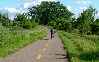
Minnehaha Trail is a 1.5-mile (2.4 km) paved, multi-use trail in Minneapolis, Minnesota, United States, that connects Minnehaha Regional Park and Fort Snelling State Park – two of the most popular recreation destinations in the Twin Cities metro area. The trail is considered a segment of a longer, loosely connected bicycle route system along the Mississippi River. Users of Minnehaha Trail traverse under a forest canopy. The trail received local recognition for its natural beauty, but it was criticized for its worn pavement and lack of signage.

Mississippi Gorge Regional Park is a regional park along the east and west bluffs of the Mississippi River in the cities of Minneapolis and Saint Paul in the U.S. state of Minnesota. The two-city park area is between Mississippi river miles 848 and 852, from just south of Northern Pacific Bridge Number 9 to just north of Minnehaha Regional Park, and lies within the Mississippi National River and Recreation Area. The park area protects scenic and natural areas of the Mississippi River gorge, the only true gorge along the entire length of the 2,320-mile (3,730 km) river.
