Kaposia

Last updated
Kaposia (Kapozha)
Kaposia Village 1846.jpg
Watercolor of Kaposia village by Seth Eastman c.1846
LocationPresent-day Saint Paul, Minnesota

Kaposia or Kapozha was a seasonal and migratory Dakota settlement, also known as "Little Crow's village," once located on the east side of the Mississippi River in present-day Saint Paul, Minnesota. The Kaposia band of Mdewakanton Dakota was established in the late 18th century and led by a succession of chiefs known as Little Crow or "Petit Corbeau." [1] After a flood in 1826, the band moved to the west side of the river, about nine miles below Fort Snelling. [2]

Contents

History

Kaposia translates to "light," "light footed" or "not encumbered with much baggage." [3] Many historians believe that the name infers that the people were traveling "light." Others have speculated that its name was in reference to the band's championship at the game of lacrosse. [3]

Location in early 19th century

On May 1, 1767, British explorer Jonathan Carver attended an "annual council" of eight bands of Dakota, "possibly at or near a village that would become Kaposia," [4] on the eastern side of the river two miles south of Wakan Tipi in St. Paul. [5]

By 1775, all Mdewakanton bands had established "more or less permanent summer villages." [3] The Kaposia band is believed to have taken residence in the St. Paul area under Chief Cetanwakanmani (c.1769–1833), grandfather of Taoyateduta Little Crow. [3]

American explorer Lieutenant Zebulon Pike visited Kaposia during his 1805–1806 expedition to locate the source of the Mississippi River. Historian Edward J. Lettermann suggests that Kaposia may have been located on what was then an "island," two miles long and up to one mile wide, between Pigs Eye Lake and the Mississippi from this time until the early 1820s. [3] The location was referred to as "The Grand Marais," also by Major Thomas Forsyth, who visited Kaposia in 1819. [3]

Sometime between 1819 and 1823, Cetanwakanmani moved the village to present-day downtown St. Paul near the mouth of Phalen Creek. [3] After the river flooded in 1826, the Kaposia band moved to the west side of the Mississippi River, [2] north of today's downtown South St. Paul. [6] Although there is some uncertainty regarding the exact date, the village most likely moved to the west bank by 1833. [3]

Economy

Woodworking was an important trade in Kaposia. Kaposia village was well known for making canoes, which were made by hollowing pine trees with axes and adze. Other items they carved included cradles, dishes, spoons and ladles. [7] The village always had cornfields and vegetable gardens nearby, which were cultivated by the women in the band. [2]

Battle of Kaposia

It was the camp the Ojibwe attacked in 1842 that named Battle Creek in St. Paul. [8] [9]

Land cession treaties

With the signing of the 1837 land cession treaty with the United States, Chief Big Thunder Little Crow and other Mdewakanton Dakota leaders relinquished their claims to all land east of the Mississippi River. [10]

In 1851, Taoyateduta Little Crow was the first Mdewakanton Dakota signatory to the Treaty of Mendota with the United States. [11] As a result of the land cessions, all Dakota were forced to move to a reservation on either side of the Minnesota River. The people of Kaposia moved to the proximity of the Redwood Agency, also known as the Lower Sioux Agency.

Last days of Kaposia

Drawing of Kaposia village in 1851 by Frank Blackwell Mayer Kaposia Village (1851).jpg
Drawing of Kaposia village in 1851 by Frank Blackwell Mayer

Colonel Seth Eastman painted Kaposia below the southern bluffs of Mounds Park.[ citation needed ]

In 1851, 23-year-old artist Frank Blackwell Mayer, made a large number of sketches of life in Kaposia village. [12]

In 1854, when Little Crow III visited Washington, DC, he observed John Mix Stanley in his studio arcade. [11] In Little Crow: Spokesman for the Sioux, historian Gary Clayton Anderson writes:

Coincidentally, Stanley was just then finishing a landscape of Kaposia, complete with bark and hide lodges, women dressing. hides, and men carrying canoes to the river. Little Crow was delighted and gazed for a long time at the scene, pointing to familiar sights. But Stanley had also completed a painting of the burial ground near Kaposia, and this picture produced in the chief a more sullen mood. He looked for a long time at the depiction of the dead being mounted on scaffolds, then raised his hands above his head, clasped them, and stalked out of the room. No one watching his reaction even attempted to fathom what had been racing through his mind. No doubt he lamented the fact that he would never again return to that village so poignantly portrayed by Stanley. [11]

Notable people

Visiting

Today there is a historic site marker for Kaposia along North Concord street in South St. Paul. Kaposia Park is situated where the settlement used to exist, and is open to the public.

Related Research Articles

<span class="mw-page-title-main">Dakota County, Minnesota</span> County in Minnesota, United States

Dakota County is the third-most populous county in the U.S. state of Minnesota, located in the east central portion of the state. As of the 2020 census, the population was 439,882. The population of Dakota County was estimated to be 443,341 in 2022. The county seat is Hastings. Dakota County is named for the Dakota Sioux tribal bands who inhabited the area.

<span class="mw-page-title-main">Henry Hastings Sibley</span> American politician and military leader (1811–1891)

Henry Hastings Sibley was a fur trader with the American Fur Company, the first U.S. Congressional representative for Minnesota Territory, the first governor of the state of Minnesota, and a U.S. military leader in the Dakota War of 1862 and a subsequent expedition into Dakota Territory in 1863.

<span class="mw-page-title-main">Little Crow</span> Chief of Kaposia band of Mdewakantons

Little Crow III was a Mdewakanton Dakota chief who led a faction of the Dakota in a five-week war against the United States in 1862.

Mississippi River Band of Chippewa Indians or simply the Mississippi Chippewa, are a historical Ojibwa Band inhabiting the headwaters of the Mississippi River and its tributaries in present-day Minnesota.

The Mdewakanton or Mdewakantonwan are one of the sub-tribes of the Isanti (Santee) Dakota (Sioux). Their historic home is Mille Lacs Lake in central Minnesota. Together with the Wahpekute, they form the so-called Upper Council of the Dakota or Santee Sioux. Today their descendants are members of federally recognized tribes in Minnesota, South Dakota and Nebraska of the United States, and First Nations in Manitoba, Canada.

<span class="mw-page-title-main">Big Eagle</span> Native American leader (Dakota chief)

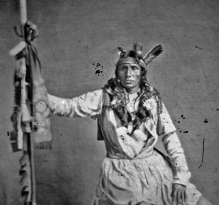
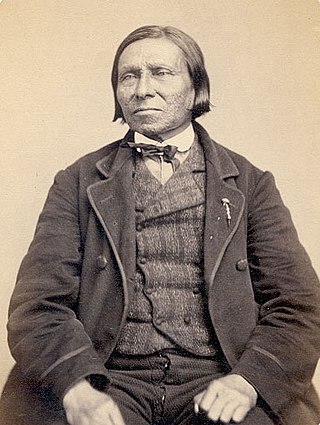
Big Eagle was the chief of a band of Mdewakanton Dakota in Minnesota. He played an important role as a military leader in the Dakota War of 1862. Big Eagle surrendered soon after the Battle of Wood Lake and was sentenced to death and imprisoned, but was pardoned by President Abraham Lincoln in 1864. Big Eagle's narrative, "A Sioux Story of the War" was first published in 1894, and is one of the most widely cited first-person accounts of the 1862 war in Minnesota from a Dakota point of view.

<span class="mw-page-title-main">Treaty of Traverse des Sioux</span> Upper Dakota land cession treaty of 1851 with United States

The Treaty of Traverse des Sioux was signed on July 23, 1851, at Traverse des Sioux in Minnesota Territory between the United States government and the Upper Dakota Sioux bands. In this land cession treaty, the Sisseton and Wahpeton Dakota bands sold 21 million acres of land in present-day Iowa, Minnesota and South Dakota to the U.S. for $1,665,000.

<span class="mw-page-title-main">Pike Island</span> River island in Minnesota, United States

Pike Island is an island at the confluence of the Mississippi and Minnesota rivers in the southwestern-most part of Saint Paul in the U.S. state of Minnesota. The island is managed as part of Fort Snelling State Park and is within the Mississippi National River and Recreation Area. For centuries, Dakota people have considered the area of the island to be a sacred place where they moved with the seasons to find food and resources. The island is named after Zebulon Pike, who negotiated the United States government purchase of the area from Mdewakanton Sioux Indians in 1805.

<span class="mw-page-title-main">Surrender at Camp Release</span>

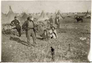
The Surrender at Camp Release was the final act in the Dakota War of 1862. After the Battle of Wood Lake, Colonel Henry Hastings Sibley had considered pursuing the retreating Sioux, but he realized he did not have the resources for a vigorous pursuit. Furthermore, he was aware that Chief Little Crow had been losing support and was in contact with several Mdewakanton chiefs who had signaled their opposition to further conflict.

<span class="mw-page-title-main">Dakota War of 1862</span> Armed conflict between the United States and four bands of the eastern Dakota

The US–Dakota War of 1862, also known as the Sioux Uprising, the Dakota Uprising, the Sioux Outbreak of 1862, the Dakota Conflict, or Little Crow's War, was an armed conflict between the United States and several eastern bands of Dakota collectively known as the Santee Sioux. It began on August 18, 1862, when the Dakota, who were facing starvation and displacement, attacked white settlements at the Lower Sioux Agency along the Minnesota River valley in southwest Minnesota. The war lasted for five weeks and resulted in the deaths of hundreds of settlers. In the aftermath, the Dakota people were exiled from their homelands, forcibly sent to reservations in the Dakotas and Nebraska, and the State of Minnesota confiscated and sold all their remaining land in the state. The war also ended with the largest mass hanging in United States history with hanging of 38 Dakota men.

<span class="mw-page-title-main">Dakota people</span> Native American people in the mid northern U.S. and mid southern Canada

The Dakota are a Native American tribe and First Nations band government in North America. They compose two of the three main subcultures of the Sioux people, and are typically divided into the Eastern Dakota and the Western Dakota.

<span class="mw-page-title-main">Gabriel Renville</span>

Gabriel Renville, also known as Ti'wakan, was Chief of the Sisseton Wahpeton Oyate Sioux Tribe from 1866 until his death in 1892. He opposed conflict with the United States during the Dakota War of 1862 and was a driving force within the Dakota Peace Party. Gabrielle Renville's influence and political leadership were critical to the eventual creation of the Lake Traverse Indian Reservation, which lies mainly in present-day South Dakota.

Shakopee or Chief Shakopee may refer to one of at least three Mdewakanton Dakota leaders who lived in the area that became Minnesota from the late 18th century through 1865. The name comes from the Dakota Śakpe meaning "Six." According to tribal histories, the very first "Shakpe" was called that because he was the sixth child of a set of sextuplets.

<span class="mw-page-title-main">Wapasha II</span> Mdewakanton Dakota leader

Wabasha II, also known as Wapahasha, Wapasha, or "The Leaf," succeeded his father as head chief of the Mdewakanton Dakota tribe in the early 1800s. He led the Dakota forces fighting with the British in the War of 1812, but sided with the United States in the Black Hawk War of 1832. Chief Wabasha II signed the Treaties of Prairie du Chien in 1825 and 1830.

<span class="mw-page-title-main">Wabasha III</span> Head chief of Santee Sioux

Wabasha III (Wapahaśa) was a prominent Dakota Sioux chief, also known as Joseph Wabasha. He succeeded his father as head chief of the Mdewakanton Dakota in 1836. Following the Dakota War of 1862 and the forced removal of the Dakota to Crow Creek Reservation, Wabasha became known as head chief of the Santee Sioux. In the final years of his life, Chief Wabasha helped his people rebuild their lives at the Santee Reservation in Nebraska.

Wacouta I (Shooter) was a leader of the Red Wing band of Mdewakanton Dakota during the time of United States expansion into his people's homeland.

Red Wing II, also known as Tatankamani was a leader of the Mdewakanton Dakota in the upper Mississippi Valley. During the War of 1812, Chief Red Wing II initially supported the British together with other Dakota chiefs, but switched sides to support the Americans in 1814. His village was at Barn Bluff in present-day Red Wing, Minnesota.


Mendota Mdewakanton Dakota Tribal Community is a Dakota community centered in Mendota, Minnesota. The Mendota Mdewakanton Dakota Tribal Community, colloquially known as MMDTC, is an organization who works to continue Dakota cultural practices and tribal organization. Officially formed in 1997, the MMDTC has sought to be a federally recognized tribe by the US Bureau of Indian Affairs, as well as offering community activities such as Pow Wows, Dakota language and culture classes, and partnership with the Minnesota Historical Society.

<span class="mw-page-title-main">Snana</span> Dakota woman also known as Maggie Brass (1839-1908)

Snana (1839–1908), also known as Maggie Brass, was a Mdewakanton Dakota woman who rescued and protected a fourteen-year-old German girl, Mary Schwandt, after she was taken captive during the Dakota War of 1862. She was reunited with Mary Schwandt Schmidt in 1894, leading to a feature article in the St. Paul Pioneer Press. Snana’s narrative of the war, “Narration of a Friendly Sioux,” was edited by historian Return Ira Holcombe and published in 1901.

<span class="mw-page-title-main">Azayamankawin</span> 19th century Dakota woman known as Old Bets

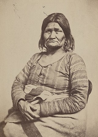
Azayamankawin, also known as Hazaiyankawin, Betsey St. Clair, Old Bets, or Old Betz, was one of the most photographed Native American women of the 19th century. She was a Mdewakanton Dakota woman well known in Saint Paul, Minnesota, where she once ran a canoe ferry service. Old Bets was said to have helped many women and children taken captive during the Dakota War of 1862.

References

  1. "Kaposia: Dakota Village on the Mississippi River". HMdb.org, The Historical Marker Database. June 10, 2020. Retrieved 2021-06-09.
  2. 1 2 3 Diedrich, Mark (1995). Old Betsey: The Life and Times of a Famous Dakota Woman and Her Family. Rochester, Minnesota: Coyote Press. p. 15. ISBN   0-9616901-9-4.
  3. 1 2 3 4 5 6 7 8 Lettermann, Edward J. (1969). From Whole Log to No Log: A History of the Indians Where the Mississippi and the Minnesota Rivers Meet. Minneapolis: Dillon Press. pp. 55, 80–81. ISBN   9780875180120. LCCN   79-91356.
  4. "River of History – Chapter 3". National Park Service – Mississippi – National River and Recreation Area Minnesota. Retrieved 2021-08-08.
  5. Carver's Cave- Subterranean Twin Cities, G.A. Brick, gregbrick.org
  6. National Park Service National Park Service – Kaposia
  7. Jones, Evan (1966). Citadel in the Wilderness; The Story of Fort Snelling and the Old Northwest Frontier. New York: Coward McCann. p. 62. LCCN   66020154.
  8. Warner, George (1881). History of Ramsey County and the city of St. Paul, including the Explorers and pioneers of Minnesota. Minneapolis, Minnesota: North Star Publishing Company. p. 183. ISBN   9780353481787.
  9. "The Battle of Battle Creek". Maplewood, MN. Retrieved August 1, 2021.
  10. Clemmons, Linda (2005). "'We Will Talk of Nothing Else': Dakota Interpretations of the Treaty of 1837". Great Plains Quarterly. 186.
  11. 1 2 3 Anderson, Gary Clayton (1986). Little Crow: Spokesman for the Sioux. St. Paul: Minnesota Historical Society Press. pp. 63, 73. ISBN   0-87351-196-4.
  12. Mayer, Frank Blackwell (1986). With Pen and Pencil on the Frontier in 1851 (2004 ed.). St. Paul: Minnesota Historical Society Press. p. 23. ISBN   0-87351-195-6.

Further reading