The Mississippi River is the second-longest river and chief river of the second-largest drainage system in North America, second only to the Hudson Bay drainage system. From its traditional source of Lake Itasca in northern Minnesota, it flows generally south for 2,340 miles (3,770 km) to the Mississippi River Delta in the Gulf of Mexico. With its many tributaries, the Mississippi's watershed drains all or parts of 32 U.S. states and two Canadian provinces between the Rocky and Appalachian mountains. The main stem is entirely within the United States; the total drainage basin is 1,151,000 sq mi (2,980,000 km2), of which only about one percent is in Canada. The Mississippi ranks as the thirteenth-largest river by discharge in the world. The river either borders or passes through the states of Minnesota, Wisconsin, Iowa, Illinois, Missouri, Kentucky, Tennessee, Arkansas, Mississippi, and Louisiana.

Saint Paul is the capital of the U.S. state of Minnesota and the county seat of Ramsey County. Situated on high bluffs overlooking a bend in the Mississippi River, Saint Paul is a regional business hub and the center of Minnesota's government. The Minnesota State Capitol and the state government offices all sit on a hill close to the city's downtown district. One of the oldest cities in Minnesota, Saint Paul has several historic neighborhoods and landmarks, such as the Summit Avenue Neighborhood, the James J. Hill House, and the Cathedral of Saint Paul. Like the nearby and larger city of Minneapolis, Saint Paul is known for its cold, snowy winters and humid summers.

Minneapolis–Saint Paul is a metropolitan area in the Upper Midwestern United States centered around the confluence of the Mississippi, Minnesota and St. Croix rivers in the U.S. state of Minnesota. It is commonly known as the Twin Cities after the area's two largest cities, Minneapolis and Saint Paul. Minnesotans often refer to the two together simply as "the cities". It is Minnesota's economic, cultural, and political center.

Winona is a city in and the county seat of Winona County, in the state of Minnesota. Located in bluff country on the Mississippi River, its most noticeable physical landmark is Sugar Loaf. The city is named after legendary figure Winona, who some sources claimed was the first-born daughter of Chief Wapasha of the Dakota people. The population was 25,948 at the 2020 census.

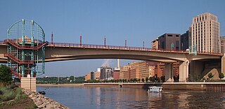
The Stone Arch Bridge is a former railroad bridge crossing the Mississippi River at Saint Anthony Falls in downtown Minneapolis, Minnesota. It is the only arched bridge made of stone on the entire Mississippi River. It is the second oldest bridge on the river next to Eads Bridge. The bridge was built to connect the railway system to the new Union Depot, which at that time was planned to be built between Hennepin Avenue and Nicollet Avenue. The bridge was completed in 1883, costing $650,000 at the time. 117 Portland Avenue is the general address of the historic complex.

Lake Street is a major east-west thoroughfare between 29th and 31st streets in Minneapolis, Minnesota United States. From its western most end at the city's limits, Lake Street reaches the Chain of Lakes, passing over a small channel linking Bde Maka Ska and Lake of the Isles, and at its eastern most end it reaches the Mississippi River. In May 2020, the Lake Street corridor suffered extensive damage during local unrest over the murder of George Floyd. In August of the same year, city officials designated East Lake Street as one of seven cultural districts to promote racial equity, preserve cultural identity, and promote economic growth.

Interstate 35W (I-35W) is an Interstate Highway in the US state of Minnesota, passing through downtown Minneapolis. It is one of two through routes for I-35 through the Twin Cities of Minneapolis and Saint Paul, the other being I-35E through downtown Saint Paul.

The Mississippi National River and Recreation Area is a 72-mile (116 km) and 54,000-acre (22,000 ha) protected corridor along the Mississippi River through the Minneapolis–Saint Paul metro in the U.S. state of Minnesota, from the cities of Dayton and Ramsey, to just downstream of Hastings. This stretch of the upper Mississippi River includes natural, historical, recreational, cultural, scenic, scientific, and economic resources of national significance. This area is the only national park site dedicated exclusively to the Mississippi River. The Mississippi National River and Recreation Area is sometimes abbreviated as MNRRA or MISS, the four letter code assigned to the area by the National Park Service. The Mississippi National River and Recreation Area is classified as one of four national rivers in the United States, and despite its name it is technically not one of the 40 national recreation areas.
The Wabasha Street Bridge is a segmental bridge that spans the Mississippi River in downtown Saint Paul, Minnesota, United States. It was named Wabasha Street Freedom Bridge in 2002, to commemorate the first anniversary of the September 11 attacks. It actually consists of two separate bridges, one for northbound and one for southbound traffic. The use of a concrete segmental box girder bridge provided a construction advantage because no falsework needed to be built beneath the bridge.

St. Paul Union Pacific Rail Bridge, also known as the Hoffman Swing Bridge, is a swing bridge that spans the Mississippi River between South Saint Paul, Minnesota and Saint Paul, Minnesota in the United States. It was built in 1910 by the St. Paul Bridge and Terminal Railway, and was rebuilt in 1925, after a flood in 1951, and again in 1982.

Minneapolis is the largest city by population in the U.S. state of Minnesota, and the county seat of Hennepin County. The origin and growth of the city was spurred by the proximity of Fort Snelling, the first major United States military presence in the area, and by its location on Saint Anthony Falls, which provided power for sawmills and flour mills.
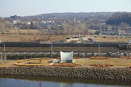
The Harriet Island Pavilion, also known as the Clarence W. Wigington Pavilion, is a park pavilion on Harriet Island just across the Mississippi River from downtown Saint Paul, Minnesota, United States. It was designed by Clarence W. Wigington, the nation's first black municipal architect, and renamed for Wigington after a 2000 restoration. Harriet island was named for Harriet Bishop, a Baptist school teacher from Vermont. She arrived in Saint Paul in 1847, was involved in the temperance movement, and opened the first school in the frontier city, teaching children of diverse ethnic, racial, and religious backgrounds.

Saint Paul, Minnesota is noted for its neighborhoods. The city has been called "fifteen small towns with one mayor", owing to the neighborhood-based life of much of the city. Saint Paul is partially governed by not 15 but 17 City Districts.
Edward Phelan, also Phalen or Felyn (c.1811-1850), was an early settler of Saint Paul, Minnesota. Phelan was born in approximately 1811 in Derry, Ireland and later became, along with John Hays and William Evans, one of the first settlers of Saint Paul. Phelan was later accused of Hays' murder, the first ever in Saint Paul, but was acquitted. He was indicted for perjury a year later but fled to California before he could be prosecuted. Phelan was killed by his companions in what they describe as self-defense before he could reach California. Many locations in Saint Paul, Minnesota are named after Phelan as a result of his early land claims. Phelan's name was spelled variously and as a result most locations are named Phalen and not Phelan

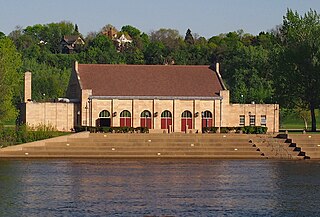
The Minnesota Boat Club Boathouse on Raspberry Island is a historic structure in Saint Paul, Minnesota, United States. It is the home of the Minnesota Boat Club, a rowing club founded in 1870, that is Minnesota's oldest athletic organization. In 1885, a wooden structure was built on Raspberry Island to house the Minnesota Boat Club. The club constructed a new boathouse in 1910, which was designed by George H. Carsley in the style of Mission Revival architecture. The boathouse building was listed on the National Register of Historic Places in 1982.

West Seventh is a neighborhood in Saint Paul, Minnesota, United States. This area is colloquially known as the West End, and is not to be confused with the West Side, a different neighborhood. The West End lies at the base of Summit Hill and along the western bluffs of the Mississippi River, spanning the entire length of West Seventh Street, or Old Fort Road; it is also known as the Fort Road area. Fort Road was a historic Native American and fur trader path along the Mississippi River from downtown Saint Paul to Fort Snelling.

Selby Avenue is a street in Saint Paul, Minnesota, United States, that runs east–west from Summit Avenue near downtown toward the Mississippi River. The street runs through the Summit-University and Union Park neighborhoods. The street, especially between Dale Street and Snelling Avenue, has been associated with Saint Paul's black community. The far eastern end of the street has historically been more densely developed and architecturally significant.
Watergate Marina is located on the north bank of the Mississippi River in Saint Paul, Minnesota, United States, upriver from the city's downtown area. Owned by the City of Saint Paul and operated via lease, the privately run, full-service marina has capacity for 160 ships and it charges fees for boat launches.

Mississippi Gorge Regional Park is a regional park along the east and west bluffs of the Mississippi River in the cities of Minneapolis and Saint Paul in the U.S. state of Minnesota. The two-city park area is between Mississippi river miles 848 and 852, from just south of Northern Pacific Bridge Number 9 to just north of Minnehaha Regional Park, and lies within the Mississippi National River and Recreation Area. The park area protects scenic and natural areas of the Mississippi River gorge, the only true gorge along the entire length of the 2,320-mile (3,730 km) river.

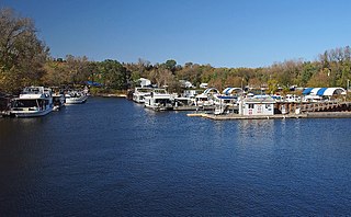
Latsch Island is an island located on the Mississippi river, and is part of the city of Winona, Minnesota. Latsch Island is best known for its off-the-grid counterculture houseboat ("boathouse") community, who occupy the eastern coastline of the island. During periods of flooding or high water levels, the island sometimes becomes two islands, with the eastern section referred to as Wolf Spider Island.