Mississippi Gorge Regional Park

Last updated
Mississippi Gorge
Regional Park
Mississippi River Gorge Regional Park
ShortLineBridgeView.JPG
Bluffs of the Mississippi River from the Short Line Bridge looking north
Mississippi Gorge Regional Park
Type Regional park
LocationU.S. state of Minnesota
Coordinates 44°56′10″N93°12′2″W / 44.93611°N 93.20056°W / 44.93611; -93.20056 [1]
Area132 acres (53 ha) in Minneapolis [1]
Elevation747 feet (228 m)
Owned by
Managed by
VisitorsGorge park total visits:
  • 1,189,000 in Minneapolis
  • 1,545,300 in Saint Paul
(in 2017) [2]
StatusOpen
Paths
Terrain River gorge of the Mississippi
Designation Mississippi National River and Recreation Area
Public transit access MetroTransit buses
Website

Mississippi Gorge Regional Park is a regional park along the east and west bluffs of the Mississippi River in the cities of Minneapolis and Saint Paul in the U.S. state of Minnesota. The two-city park area is between Mississippi river miles 848 and 852, from just south of Northern Pacific Bridge Number 9 to just north of Minnehaha Regional Park, and lies within the Mississippi National River and Recreation Area. The park area protects scenic and natural areas of the Mississippi River gorge, the only true gorge along the entire length of the 2,320-mile (3,730 km) river. [3]

Contents

In Minneapolis, Mississippi Gorge Regional Park is managed by the Minneapolis Park and Recreation Board. In Saint Paul, the park area's official name is the Mississippi River Gorge Regional Park, and is managed by the Park and Recreation Department. The 132-acre (53 ha) park (acreage for Minneapolis parkland only [1] ) provides access to the river and is popular for its hiking and biking paths on the bluffs. Among local residents, the gorge is known and appreciated for its semi-wild character in the middle of an urban metropolitan area. [1] The two-city park areas had a combined 2.7 million visits in 2017. [2]

History

Remnants of the historic Meeker Island lock and dam in Saint Paul, 2013 Meeker Island Lock.JPG
Remnants of the historic Meeker Island lock and dam in Saint Paul, 2013

The Mississippi River gorge was formed over thousands of years by the retreating River Warren Falls that are known today as Saint Anthony. Softer sandstone gave way and slowly collapsed the harder limestone and shale layers in to the valley. [4] The river valley in Minneapolis and Saint Paul is the only gorge along the entire 2,320-mile (3,730 km) length of the Mississippi River [5] [3] with bluffs rising as high as 150 feet (46 m). [6] The river through the gorge was a series of rapids until the early 1900s when it was reconfigured for commercial navigation with installment of locks and dams. [7]

A 72-mile (116 km) corridor of the Mississippi through the Twin Cities was designated by Minnesota Governor Wendell Anderson in 1972 as a critical natural resource area. In 1998, the United States Congress created the Mississippi National River and Recreation Area for the same corridor, bringing federal support and designation to the gorge area. [8]

The land area between the two bluffs is managed as public park land by the cities of Minneapolis and Saint Paul. The Minneapolis Park and Recreation Board, an independent park district, manages the park area in Minneapolis, which is officially named Mississippi Gorge Regional Park and includes the 132 acres of land area flanking both the east and west banks of the Mississippi River, from just south of Bridge Number 9 to the north edge of Minnehaha Regional Park. In Saint Paul, the park area is officially named Mississippi River Gorge Regional Park, and is managed by the city's Park and Recreation Department. In recent years, communities and park agencies have formed partnerships to improve the ecologic health of the gorge. In the late 1990s, the National Park Service, Minneapolis park board, and Longfellow community council restored an oak savanna near East 36th Street, which allowed park visitors to experience what the gorge area looked like before European-American settlement. [4]

Park areas

The regional parks in Minneapolis and Saint Paul contain several distinct historic sites and parks along the gorge. [1] [9]

Minneapolis

Bluff Street Park - There is an upper and lower portion of the 5.3-acre (2.1 ha) park in the Cedar-Riverside neighborhood and a trail that connects downtown Minneapolis with Bridge Number 9 and the University of Minnesota. [10]

Bohemian Flats - The location of the historic Little Bohemia shanty town has picnic areas and river cruise boats. [11]

East River Flats Park - Located just below the University of Minnesota on the east bank of the Mississippi below the bluffs, it is the training site of the women's rowing team and contains grassy areas, picnic tables, and trails. [12]

East River Parkway - The 2-mile (3.2 km) pedestrian and bike trail that runs along the east bluff of the Mississippi from Washington Avenue to Emerald Street. [13]

Franklin Terrace Dog Park - The 1.37-acre (0.55 ha), fenced area off Franklin Terrace in the Seward neighborhood for off-leash dogs is adjacent to Riverside Park. [14]

Riverside Park - The 27.68-acre (11.20 ha) park on the bluff features structures constructed by the Works Progress Administration, a playground, and a wading pool. [15]

West River Parkway - The 7.24-mile (11.65 km) pedestrian and bike trail that runs along the west bluff of the Mississippi from Plymouth Avenue to Godfrey Parkway. [13]

Saint Paul

Meeker Island Lock and Dam - Located at the river bottom below the bluffs, the historic dam site features hiking trails and an off leash dog park. [9] [16]

Visitors

The two-park gorge area is among the ten most visited sites annually in Minnesota. [17] In 2017, Mississippi Gorge Regional Park in Minneapolis had 1,189,000 total visits, and Saint Paul's Mississippi Gorge Regional Park had 1,545,300 total visits. [2]

Recreation

Canoeists on the Mississippi River in Minneapolis with the Franklin Avenue Bridge behind them, 2008 Canoeing by the Franklin Avenue Bridge in Minneapolis.tif
Canoeists on the Mississippi River in Minneapolis with the Franklin Avenue Bridge behind them, 2008

Mississippi Gorge Regional Park is popular for hiking, birdwatching, and photography. The abundance of sugar maples along the bluffs lend to a variety of colors with the changing fall leaves. [4] The gorge provides habitat for at least 150 species of migratory birds [1] and a growing population of bald eagles. [18]

Along both sides of the gorge, the East River and West River parkways of the Grand Rounds National Scenic Byway feature miles of paved, shared-used paths for walking and cycling that connect to a regional trail system. [1] Adjoining natural surface paths from the parkways provide pedestrian access to the river for sightseeing and fishing. In winter, snowshoeing and cross-country skiing are allowed on park trails. Mountain biking is prohibited on all natural surface trails in the gorge due to threats of erosion and potential damage to native plants. [19]

On the river's west bank in Minneapolis, hikers and trail runners can traverse the regional park via Winchell Trail, 2.5-mile (4.0 km) rustic path from Franklin Avenue to East 44th Street. The mostly natural-surface hiking trail provides access to the floodplain forest, sandy beaches, and an oak savanna restoration project. Several limestone staircases constructed by the Works Progress Administration descend from the West River Parkway to the gorge floor. [20] [19]

The river and gorge can also be explored via watercraft. The gorge is a segment of Mississippi River State Water Trail that passes through it. [6] Chartered river cruise boats depart seasonally from Bohemian Flats. [8] The Minneapolis Rowing Club boathouse is below the Lake Street-Marshall Bridge for serious athletes and amateurs to paddle on the river. [21] Canoes and kayaks can be launched as several locations in the gorge with routes from Hidden Falls and the rowing club boathouse most recommended. [22] The locks and dams on opposite ends of the gorge have closed permanently to commercial and recreation traffic to block invasive carp species. [23]

See also

Related Research Articles

<span class="mw-page-title-main">Minnehaha Park (Minneapolis)</span> United States historic place

Minnehaha Park is a city park in Minneapolis, Minnesota, United States, and home to Minnehaha Falls and the lower reaches of Minnehaha Creek. Officially named Minnehaha Regional Park, it is part of the Minneapolis Park and Recreation Board system and lies within the Mississippi National River and Recreation Area, a unit of the National Park Service. The park was designed by landscape architect Horace W.S. Cleveland in 1883 as part of the Grand Rounds Scenic Byway system, and was part of the popular steamboat Upper Mississippi River "Fashionable Tour" in the 1800s.

<span class="mw-page-title-main">Grand Rounds National Scenic Byway</span> Parkway system in Minneapolis

The Grand Rounds National Scenic Byway is a linked series of park areas in Minneapolis, Minnesota, United States, that takes a roughly circular path through the city. The Minneapolis Park and Recreation Board developed the system over many years. The corridors include roads for automobile traffic plus separate paths for pedestrians and bicycles, and extend slightly into neighboring cities. About 50 miles (80 km) of roadway and paths are in the system, and much of it was built in the 1930s as part of Civilian Conservation Corps projects.

<span class="mw-page-title-main">Midtown Greenway</span> Shared-use path in Minneapolis, USA

The Midtown Greenway is a 5.7-mile (9.2 km) rail trail in Minneapolis, Minnesota that follows the path of an abandoned route of the Milwaukee Road railway. It is considered under segregated cycle facilities.

<span class="mw-page-title-main">Fort Snelling State Park</span> State park in Minnesota, United States

Fort Snelling State Park is a state park of the U.S. state of Minnesota, at the confluence of the Mississippi and Minnesota rivers. For many centuries, the area of the modern park has been of importance to the Mdewakanton Dakota people who consider it the center of the Earth. The state park, which opened in 1962, is named for the historic Fort Snelling, which dates from 1820. The fort structure is maintained and operated by the Minnesota Historical Society. The bulk of the state park preserves the bottomland forest, rivers, and backwater lakes below the river bluffs. Both the state and historic fort structure are part of the Mississippi National River and Recreation Area, a National Park Service site.

<span class="mw-page-title-main">Mississippi National River and Recreation Area</span> National Park Service area in the United States

The Mississippi National River and Recreation Area is a 72-mile (116 km) and 54,000-acre (22,000 ha) protected corridor along the Mississippi River through the Minneapolis–Saint Paul metro in the U.S. state of Minnesota, from the cities of Dayton and Ramsey, to just downstream of Hastings. This stretch of the upper Mississippi River includes natural, historical, recreational, cultural, scenic, scientific, and economic resources of national significance. This area is the only national park site dedicated exclusively to the Mississippi River. The Mississippi National River and Recreation Area is sometimes abbreviated as MNRRA or MISS, the four letter code assigned to the area by the National Park Service. The Mississippi National River and Recreation Area is classified as one of four national rivers in the United States, and despite its name it is technically not one of the 40 national recreation areas.

<span class="mw-page-title-main">Three Rivers Park District</span> Park district in the Twin Cities

Three Rivers Park District is a special park district serving the suburban areas of the Twin Cities including suburban Hennepin, Carver, Dakota, Scott, and Ramsey counties. Three Rivers's mission is "To promote environmental stewardship through recreation and education in a natural resources-based park system." Three Rivers operates twenty parks and ten regional trails, with at least two more regional trails planned. Nearly seven million people visit Three Rivers facilities each year. It has over 27,000 acres (11,000 ha) of parks and trails.

<span class="mw-page-title-main">Longfellow, Minneapolis</span> Community of Minneapolis

Longfellow is a defined community in Minneapolis, Minnesota which includes five smaller neighborhoods inside of it: Seward, Cooper, Hiawatha, Howe and Longfellow. The community is a mix of agri-industrial properties along the old Northern Pacific Railway, expansive parkland surrounding the famous Minnehaha Falls, and smaller residential areas.

Minneapolis is the largest city in the state of Minnesota in the United States, and the county seat of Hennepin County.

<span class="mw-page-title-main">North Mississippi Regional Park</span>

North Mississippi Regional Park is a joint effort of the Minneapolis Park and Recreation Board and the Three Rivers Park District and lies within the larger Mississippi National River and Recreation Area. The park, located near the northern border of Minneapolis, Minnesota, borders the western shore of the Mississippi River. Connected to the Grand Rounds Scenic Byway through biking trails, it ties the Anoka County park system to the parkways of Minneapolis.

<span class="mw-page-title-main">Cycling in Minnesota</span>

Cycling in Minnesota is a popular form of recreation, commuting, and competitive sport that has grown in prominence over the years. It has been a popular activity in the state since the late 19th century.

<span class="mw-page-title-main">Mississippi River Trail</span> Long-distance bicycle route

The Mississippi River Trail is a designated bicycle and pedestrian trail that traverses the shores of the Mississippi River in the United States. The trail extends from the headwaters at Lake Itasca in Minnesota to near the mouth of the river in Venice, Louisiana. Much of the trail’s 3,000 miles (4,800 km) follows roadways used by motor vehicles, although some of the route is on multi-use trails. The segment in Minnesota has been designated as U.S. Bicycle Route 45, part of the U.S. Bicycle Route System.

<span class="mw-page-title-main">Minneapolis Park and Recreation Board</span> Local governing body

The Minneapolis Park and Recreation Board (MPRB) is an independent park district that owns, maintains, and programs activities in public parks in Minneapolis, Minnesota, United States. It has 500 full-time and 1,300 part-time employees and an $111 million operating and capital budget.

<span class="mw-page-title-main">Winchell Trail</span> Hiking area in Minneapolis

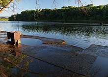
Winchell Trail is a five-mile (8 km) round trip, pedestrian-only trail in Minneapolis, Minnesota, United States, that runs along the west side of the Mississippi River between Franklin Avenue South and East 44th Street. Popular with bird watchers and naturalists, the rustic trail provides Upper Mississippi River gorge access and views. The trail is separate from the adjacent multi-use bicycle path, taking hikers past sandy beaches, an oak savanna restoration project, and the floodplain forest. The trail has multiple access points and the section from East 38th Street to East 44th Street is paved. Described as moderate and for all hiking skill levels, the out-and-back Winchell Trail has total elevation gain of 501 feet (153 m). Portions of the trail can be hiked in near solitude as its age and general destitute make it a widely forgotten place to explore.

<span class="mw-page-title-main">Minnehaha Trail</span> Shared-use path in Minneapolis

Minnehaha Trail is a 1.5-mile (2.4 km) paved, multi-use trail in Minneapolis, Minnesota, United States, that connects Minnehaha Regional Park and Fort Snelling State Park – two of the most popular recreation destinations in the Twin Cities metro area. The trail is considered a segment of a longer, loosely connected bicycle route system along the Mississippi River. Users of Minnehaha Trail traverse under a forest canopy. The trail received local recognition for its natural beauty, but it was criticized for its worn pavement and lack of signage.

<span class="mw-page-title-main">Minnehaha Falls Lower Glen Trail</span> Hiking area in Minneapolis

Minnehaha Falls Lower Glen Trail is a popular hiking route in Minneapolis, Minnesota, United States. The 2.1-mile (3.4 km) trail loop begins and ends at the base of the iconic Minnehaha Falls. Hikers follow natural trails and elevated boardwalks through a sedimentary rock glen carved by Minnehaha Creek to its confluence with the Mississippi River where there is a sandy beach. Portions of the trail loop are rated moderate to challenging in difficulty.

<span class="mw-page-title-main">Minnesota Valley State Trail</span> Multi-use recreation pathway along the Minnesota River

Minnesota Valley State Trail is a 27-mile, multi-use trail in the Minneapolis-Saint Paul metropolitan area that runs parallel to the Minnesota River from the cities of Belle Plaine to Shakopee. A 10-mile segment of the trail from Chaska to Shakopee is paved. Allowable trail uses include hiking, biking, horseback riding, cross-country skiing, and snowmobiling. First established in 1969, and never fully completed, the trail is undergoing a 13.5 mile extension in 2019 and 2020.

<span class="mw-page-title-main">Trails in Minneapolis</span>

Minneapolis is often considered one of the top biking and walking cities in the United States due to its vast network of trails and dedicated pedestrian areas. In 2020, Walk Score rated Minneapolis as 13th highest among cities over 200,000 people. Some bicycling ratings list Minneapolis at the top of all United States cities, while others list Minneapolis in the top ten. There are over 80 miles (130 km) of paved, protected pathways in Minneapolis for use as transportation and recreation. The city's Grand Rounds National Scenic Byway parkway system accounts for the vast majority of the city's shared-use paths at approximately 50 miles (80 km) of dedicated biking and walking areas. By 2008, other city, county, and park board areas accounted for approximately 30 miles (48 km) of additional trails, for a city-wide total of approximately 80 miles (130 km) of protected pathways. The network of shared biking and walking paths continued to grow into the late 2010s with the additions of the Hiawatha LRT Trail gap remediation, Min Hi Line pilot projects, and Samatar Crossing. The city also features several natural-surface hiking trails, mountain-biking paths, groomed cross-country ski trails in winter, and other pedestrian walkways.

Minnesota Scenic Byways are a system of roads in the U.S. state of Minnesota which pass through areas of scenic, cultural, or recreational significance. There are currently 22 scenic byways in the system with a total length of 2,948 miles (4,744 km). Eight of these byways are also designated as National Scenic Byways, and the North Shore Scenic Drive is further designated as an All-American Road.

<span class="mw-page-title-main">Hidden Falls (Saint Paul, Minnesota)</span> Park and hiking area in Minnesota, United States

Hidden Falls is a waterfall along the Mississippi River bluffs in Saint Paul, Minnesota, United States. The waterfall is within Hidden Falls Regional Park, a public park maintained by the City of Saint Paul. The main feature of the park is the small, spring-fed waterfall for which the park is named. The waterfall may be dry in periods of limited precipitation.

<span class="mw-page-title-main">Crosby Farm</span> Park and historic site in Saint Paul, Minnesota, United States

Crosby Farm is a regional park in Saint Paul, Minnesota, United States, that is located in the floodplain forests along the Mississippi River. It is named after a historic farmstead owned by Thomas Crosby from 1858 to 1886. Crosby Farm Regional Park is maintained by the City of Saint Paul and is within the Mississippi National River and Recreation Area.

References

  1. 1 2 3 4 5 6 7 "Mississippi Gorge Regional Park". Minneapolis Park & Recreation Board. 2020. Retrieved 2020-12-07.
  2. 1 2 3 "Chapter 3 – Visitor Demand". Mississippi Gorge Regional Park Master Plan. Minneapolis Park and Recreation Board. 2019.
  3. 1 2 Smith, David C. (2020). "History: Mississippi Gorge Regional Park". Minneapolis Park & Recreation Board. Retrieved 2020-12-07.
  4. 1 2 3 "Mississippi Gorge Regional Park". National Park Service . 2020-02-28.
  5. "Geology and natural history of the Mississippi River Gorge". Friends of the Mississippi River. 2008-03-13. Retrieved 2020-12-08.
  6. 1 2 "Mississippi State Water Trail: Map 10 - Minneapolis to Hastings" (PDF). Minnesota State Parks and Trails. 2019.
  7. "Mississippi River Gorge Habitat Restoration and Trail Rehabilitation". National Park Service. 2019-02-16.
  8. 1 2 Ballalatak, Katie; Fischer, Reed (2018-06-06). "Mississippi River Adventure Guide". Minnesota Monthly. Retrieved 2020-12-08.
  9. 1 2 "Mississippi River Gorge Regional Park | Saint Paul, Minnesota". www.stpaul.gov. Retrieved 2020-12-08.
  10. "Bluff Street Park". Minneapolis Park & Recreation Board. Retrieved 2020-12-08.
  11. "Bohemian Flats Park". Minneapolis Park & Recreation Board. Retrieved 2020-12-08.
  12. "East River Flats Park". Minneapolis Park & Recreation Board. Retrieved 2020-12-08.
  13. 1 2 "Pedestrian and Bike Trail Distances". Minneapolis Park & Recreation Board. Retrieved 2020-12-08.
  14. "Franklin Terrace Off-Leash Dog Park". Minneapolis Park & Recreation Board. Retrieved 2020-12-08.
  15. "Riverside Park". Minneapolis Park & Recreation Board. Retrieved 2020-12-08.
  16. "Meeker Island Dog Park | Saint Paul, Minnesota". www.stpaul.gov. Retrieved 2020-12-08.
  17. Staff (2018-11-14). "These are the 40 most-visited attractions in Minnesota". Bring Me The News. Retrieved 2020-12-08.
  18. "Bald Eagle (Haliaeetus leucocephalus) - Mississippi National River and Recreation Area". www.nps.gov. National Park Service. 2018-06-26. Retrieved 2020-12-08.
  19. 1 2 "Chapter 2 – Park Conditions, Analysis, and Opportunities". Mississippi Gorge Regional Park Master Plan. Minneapolis Park and Recreation Board. 2019.
  20. Editors, Mpls St Paul (2018-09-28). "Best Hikes and Walks in Minnesota". Mpls.St.Paul Magazine. Retrieved 2020-12-08.{{cite web}}: |last= has generic name (help)
  21. Smith, Kelly (2018-07-27). "'Rowing Adventure' gives rookies a workout on the Mississippi River". Star Tribune. Retrieved 2020-12-08.
  22. Kasic, Christopher (2016-05-10). "A paddle on the urban Mississippi". Southwest Journal. Retrieved 2020-12-08.
  23. Stanley, Greg (2020-05-12). "An old river lock in downtown Minneapolis could have new life as a park". Star Tribune. Retrieved 2020-12-08.