Neighborhoods in Saint Paul, Minnesota

Last updated
A map of neighborhoods of Saint Paul, Minnesota. Saint Paul neighborhoods.png
A map of neighborhoods of Saint Paul, Minnesota.
Saint Paul neighborhood markers. Neighborhoods-Of-Saint-Paul.jpg
Saint Paul neighborhood markers.

Saint Paul, Minnesota, consists of 17 officially defined city districts or neighborhoods.

Contents

In its history, the city has been called "fifteen small towns with one mayor," owing to the neighborhood-based life of much of the city, though the city is partially governed by not 15 but 17 City Districts.

On Saint Paul's largely blue-collar East Side alone there are more than two dozen well-known, historically significant neighborhoods within four City Districts. District 4, for example, has three historic neighborhoods: Dayton's Bluff, Swede Hollow, and Mounds Park. The most populous districts, 2 and 5, have more than a dozen neighborhoods between them.

While Saint Paul has long been recognized for its citizen activism, some neighborhoods receive more individual planning attention[ citation needed ] than others, because tax funds are doled out to annually elected volunteer neighborhood boards based on City District boundaries, not neighborhood boundaries. These boards are called District Councils.

The District Council system was established in 1975 to encourage grassroots involvement. [1] The Councils were also created to help spend federal funds through the recently created Community Development Block Grants. The District Councils share $1.2 million from the city of Saint Paul. In 2015, community participation funds given to the District Councils ranged from $51,873 to $109,475. [2] The councils also have other revenue streams, such as grants and donations. [3] Most councils have significant power on land-use issues. [4]

Besides providing advisory recommendations to city officials on development issues, district councils also identify neighborhood needs, initiate community programs and recruit and nurture neighborhood leaders and volunteers.

Many of St. Paul's neighborhoods began as rail-line commuter suburbs, including Merriam Park, St. Anthony Park, Macalester Park, Desnoyer Park, Hazel Park, Union Park, Warrendale, and Burlington Heights. [5] Burlington Heights was south of downtown along the Burlington's tracks to Hastings. The Heights had two train stations a mile apart. The Highwood station was close to where Highwood Avenue ran into the rail line. [5] The remnants of that early 1880s development are discernible. The neighborhood boundaries were Lower Afton Road, Burlington Road, Ogdan Avenue and the Burlington train track. [5]

District Councils

Battle Creek Regional park Winter Trail at Battle Creek Regional Park, Saint Paul, Minnesota (47206742192).jpg
Battle Creek Regional park

District 1 - Eastview, Conway, Battle Creek, Highwood Hills

These four neighborhoods make up the Southeast Side, in the southeast corner of Saint Paul. They are predominantly residential communities that vary widely economically, geographically, and culturally. It is the site of both single-family homes on large lots and high density apartment complexes. Parks overlook the Mississippi River and Pig's Eye Lake, and nestle into 1960s-era neighborhoods. The area's riverfront is part of Saint Paul's working river.

District 2 - Greater East Side

The Greater East Side is among the city's largest, most populous and most diverse districts. It is in St. Paul's northeast corner. Boundaries are the city limits on the north and east; Minnehaha Avenue to the south; and Johnson Parkway to the west. It includes the neighborhoods of Frost Lake, Hillcrest, Prosperity Heights, Hayden Heights, Beaver Lake, Hazel Park, and Phalen Village. Built as bedroom communities for the industries further south on the East Side (3M, Whirlpool, Hamm’s), the neighborhoods continue to include commuter homes with retail and service industries on White Bear Avenue and in Phalen Village.

Riverview Library Riverview Branch Library (St Paul, Minnesota - 2008).jpg
Riverview Library

District 3 - West Side

The West Side is actually to the south and across the Mississippi River from Downtown Saint Paul. It is called the West Side because it is on the west bank of the predominantly north-south river. It is adjacent to the suburban cities of South St. Paul and West St. Paul. The West Side is home to one of the largest Hispanic communities in the Twin Cities, [6] centered along César Chávez Street.

District 4 - Dayton's Bluff

Dayton's Bluff is on the east side of the Mississippi in southeastern Saint Paul. It has a residential district on an elevated plateau bounded by the ridges of the Mississippi River Valley. The name commemorates Lyman Dayton (1810–1865), [7] for whom a city and a township in Hennepin County also were named. The area of the neighborhood that had views of the river valley and Downtown Saint Paul was purchased as early as the 1850s, with most of the houses being built in the 1880s. [8] On the edge of the southern and highest part of Dayton's Bluff along the Mississippi River is the Indian Mounds Park. Within the park are six remaining burial mounds from the prehistoric era of the Hopewell mound builders. [9] Dayton's Bluff has undergone much renovation and restoration in recent years.

Sunset over Lake Phalen Sunset over Lake Phalen.jpg
Sunset over Lake Phalen

District 5 - Payne-Phalen

The Payne-Phalen city district includes the Railroad Island, Phalen Park, Rivoli Bluff, Vento, Wheelock Park, and Williams Hill neighborhoods, and ranges from a blue-collar area to the south to a middle-class area north of Maryland Avenue, including upscale real estate around Lake Phalen. [6] The neighborhood was originally a 160-acre tract jointly purchased by William Sprigg Hall, Harwood Iglehart, and Charles Mackubin, Southern slaveowners who named the neighborhood's streets after the flowers of their homeland, including Hawthorn, Hyacinth, and Magnolia. [10]

District 6 - North End

One of Saint Paul’s largest residential areas, the North End houses a number of businesses, schools, churches and parks. The neighborhood was developed in the 1870s and 1880s south of Maryland Avenue, where Victorian-era homes were built on narrow lots. The neighborhood's northern half was developed in the 1920s or later; the area along Wheelock Parkway was developed in the 1950s. The main commercial corridor is Rice Street (named after the famous Minnesota politician Henry M. Rice), which became a commercial corridor in the late 1890s with the arrival of streetcars.

The North End is home to Marydale Park, Lewis Park, Sylvan Park, Lyton Park and the Front Avenue Skate Park. The North End houses numerous schools. Some of the state’s more prominent politicians, such as Henry Sibley, William Marshall and Alexander Ramsey, are laid to rest at Oakland Cemetery. The North End also marks the start of the Gateway Trail, and the Trout Brook Nature Sanctuary and Reserve is found at its eastern border. The Willow Reserve, a bird sanctuary, is a 5.5-acre wetland and home to many species of birds. The North End is rich in history and traditions dating back to the 1800s as well as embracing customs from newer arrivals, being home to the largest population of Karen and Karenni immigrants from Burma.

District 7 - Frogtown (Thomas-Dale)

Frogtown/Thomas Dale is built around University Avenue. Thomas-Dale is colloquially known as Frogtown. [11] Historically, Frogtown was a section of the current Thomas-Dale neighborhood bordered by University Avenue on the south, Van Buren Avenue on the north, Dale Street on the west and Western Avenue on the east.

Western Ave Station Western Ave Station (St Paul MN).jpg
Western Ave Station

District 8 - Summit-University

Saint Paul cathedral St Paul Cathedral from east.jpg
Saint Paul cathedral

Summit-University is an ethnically and economically diverse community west of Downtown Saint Paul. [12] It includes the historic Cathedral Hill neighborhood, as well as what remains of "old Rondo", a former neighborhood of the city. Among the many groups living in Summit-University are the Hmong community as well as the city's other Asian communities, including large numbers of Vietnamese, Laotians and Cambodians.

In the 1880s, the southern portion closest to Summit Avenue was the preeminent neighborhood to live in. Housing further north and closer to University Avenue was less grand. [13] Parts of the neighborhood experienced significant urban renewal after the 1960s which resulted in the destruction of the Rondo neighborhood to make way for Interstate 94. [14] Sections of the neighborhood north of Interstate 94 were torn down and replaced with developments that more closely resembled the suburbs, leaving a striking contrast with the late 19th- and early 20th-century homes south near Ramsey Hill. [15]

District 9 - West Seventh/Fort Road

West Seventh in St. Paul is also known as Fort Road, [16] owing to its location on historic Native American and fur trader paths along the northern bank of the Mississippi River from downtown Saint Paul to Fort Snelling. This area is colloquially known as the "West End", and is different from the area across the river known as the "West Side". The West Seventh neighborhood was originally a series of European immigrant neighborhoods along the western bluffs of the Mississippi River, spanning the entire length of West Seventh St. or "Old Fort Rd." During the 1880s large populations of Irish, German, Czech, Slovak and (to a lesser degree) Scandinavian immigrants moved to the West End. [17]

"Saint Paul has a rich history of active and distinct neighborhoods. To support neighborhood participation in governance, the district council planning process was created over 30 years ago." [18] There are 17 district councils, and the district council of the West End is the Fort Road Federation/District 9 Community Council. "Responsibilities of the councils include: planning and advising on the physical, economic, and social development of their areas; identifying needs; initiating community programs; recruiting volunteers; and sponsoring community events." [18] The Federation actually predates the District Council system in St. Paul. "...in 1973, a group of about a dozen community members banded together to create the West 7th/Fort Road Federation. They founded the organization on the principle that citizens acting together could maintain and improve the quality of life in their neighborhoods and help commercial endeavors prosper once again. With a $5,000 start-up grant from the Christian Sharing Fund, the young organization headed down a path of community development and support that would continue for many years to come." [19]

Today, several organizations and task forces serve the neighborhoods that make up the West End. Task forces of the Federation include West End Gardeners as well as the North High Bridge Park Task Forces; the West Seventh Business Association and its Enhancement coalition; the Irvine Park Historic District and Association; Czech and Slovak Sokol Minnesota in its historic hall on the national historic register; and the West 7th Community Center.

Como Conservatory Japanese Garden entrance Como Conservatory Japanese Garden entrance.JPG
Como Conservatory Japanese Garden entrance

District 10 - Como Park

Como Park is a neighborhood situated around Como Lake. The Como Park neighborhood has many recreational facilities, including a golf course, bike path, various open fields, a pavilion, a municipal pool, and the Como Zoo, one of two zoos in the Twin Cities (the other being the Minnesota Zoo). The Como area is also home to many of the city's ginkgo trees. There are several schools in Como Park, the public schools in the area being Chelsea Heights Elementary School and the Como Park Elementary School, the only school in the city to have its own planetarium. The primary secondary school in Como Park is Como Park Senior High School, one of the highest rated schools in the state according to Newsweek. [20] [21]

District 11 - Hamline Midway

Hamline Midway derives its name from being halfway between the downtowns of Minneapolis and Saint Paul. [22] The neighborhood includes Hamline University, Allianz Field, Ax-Man Surplus, and the Turf Club. Famous Midway natives include Peanuts cartoonist Charles M. Schulz and the band Heiruspecs. [23] [24]

District 12 - Saint Anthony Park

Saint Anthony Park, known to residents as SAP, is adjacent to the University of Minnesota Saint Paul campus, bordering Northeast Minneapolis on the west and the Minnesota State Fairgrounds on the east. It was the home to three Minnesota governors (William Marshall, 1866–70; Andrew McGill, 1887–1889; and Elmer L. Andersen, 1961–63). In the late 1800s the area was laid out as estates for the wealthy of Minneapolis. [25] It is centrally located in the Twin Cities, with a business district that contains independently owned shops and restaurants. A Carnegie Library and St. Anthony Park Elementary School are the neighborhood's focal points. SAP also has two colleges, the St. Paul campus of the University of Minnesota and Luther Seminary, and thus is home to graduate students from across the world. The area's largest park is named for former St. Anthony Park resident Nathaniel P. Langford, who was responsible for the world's first national park, Yellowstone. [22]

District 13 - Union Park

Union Park, created from the merger between former Merriam Park, Snelling Hamline, and Lexington-Hamline District Councils, is a residential neighborhood featuring a large stock of early 20th-century housing, boutique-dominated commercial strips on Selby, Cretin and Cleveland avenues, and the Mississippi National River and Recreation Area forming the neighborhood's western border. Many Union Park residents still identify their neighborhoods with the original names. Concordia University and part of the University of St. Thomas are in the district.

St Thomas campus St Thomas campus.jpg
St Thomas campus

District 14 - Macalester-Groveland

Macalester (Mac)-Groveland is an established developed neighborhood in western Saint Paul that extends east from the Mississippi River to the Summit Hill neighborhood. The neighborhood is a mix of single-family homes and apartments with corner stores and commercial corridors. The Summit Avenue Historic District, with mansions from the late 1800s, flanks the neighborhood's northern border. In recent years Grand Avenue has developed into a nationally recognized commercial street, with a mixture of national retailers and local vendors. Several colleges and universities, including the University of St. Thomas and Macalester College, are in the neighborhood. The influence of academia and college life is felt throughout the neighborhood, offering residents an array of cultural, athletic, and musical opportunities. Scenic pedestrian and bicycle trails stretch throughout Mac-Groveland, in particular along the Mississippi riverfront.

District 15 - Highland Park

Highland Park is home to St. Catherine University as well as two private preparatory schools, Cretin-Derham Hall High School and St. Paul Academy and Summit School . For 85 years the neighborhood hosted the Ford Motor Company Twin Cities Assembly Plant, where Ford Ranger and Mazda B-Series pickup trucks were produced. Ford closed the plant in 2011 and the 122 acres of prime real estate along the Mississippi is on track to become a mixed residential and commercial property. In 2018 The Ryan Companies of Minneapolis won the right to develop the property in accordance with a master zoning plan drawn up by the city of St. Paul. [27]

District 16 - Summit Hill

Summit Hill is bounded by Summit Avenue and Ramsey St. on the north, Interstate 35E on the south and east, and Ayd Mill Road on the west. One of St. Paul's oldest and most popular neighborhoods, Summit Hill is a regional and local treasure of history, architecture, distinctive pedestrian-oriented shopping and dining experiences, and strong community connections. In the 1880s and 1890s the Crocus Hill and Grand Hill neighborhoods, two residential sections of Summit Hill, became fashionable locations for wealthy families. At that time, many earlier Summit Avenue constructions were renovated or razed to make way for more fashionable, or what were thought to be architecturally significant, houses. Early railroad and lumber barons built on Summit Avenue and in the adjacent areas, with families such as the Burbanks and Weyerhaeusers leading local social life.

Summit Avenue was originally conceived as a broad, Gilded Age showcase street, and is lined with mansions named after notable Saint Paul figures, such as railroad tycoon James J. Hill. With its vistas of downtown and the Mississippi River, Summit Avenue is thought to be one of the longest stretches of preserved Victorian mansions in North America. It has been home to artists such as F. Scott Fitzgerald and his wife Zelda, Sinclair Lewis, August Wilson, and Garrison Keillor. More notorious residents have included 1930s-era gangsters such as John Dillinger and members of the Barker-Karpis Gang.

Downtown Saint Paul Downtown Saint Paul Skyline (5800232347).jpg
Downtown Saint Paul

District 17 - Downtown

Downtown Saint Paul is home to Xcel Energy Center (home of the Minnesota Wild), Cray Plaza across from Mears Park, and Wells Fargo Place. Downtown hosts several parks, most notably Rice Park, one of the oldest parks in the country. The street life has been improving in some areas of downtown, including Mears Park bars and restaurants and along Wabasha and St. Peter Streets, where a small collection of restaurants has developed. The extensive skyway system connecting most of the office buildings has contributed to the removal of foot traffic from the streets. [28]

See also

Related Research Articles

<span class="mw-page-title-main">Saint Paul, Minnesota</span> Capital city of Minnesota, United States

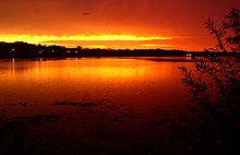
Saint Paul is the capital of the U.S. state of Minnesota and the county seat of Ramsey County. Situated on high bluffs overlooking a bend in the Mississippi River, Saint Paul is a regional business hub and the center of Minnesota's government. The Minnesota State Capitol and the state government offices all sit on a hill close to the city's downtown district. One of the oldest cities in Minnesota, Saint Paul has several historic neighborhoods and landmarks, such as the Summit Avenue Neighborhood, the James J. Hill House, and the Cathedral of Saint Paul. Like the adjacent city of Minneapolis, Saint Paul is known for its cold, snowy winters and humid summers.

<span class="mw-page-title-main">University Avenue (Minneapolis–Saint Paul)</span>

University Avenue is a street that runs through both Minneapolis and Saint Paul, Minnesota. It begins near the Minnesota State Capitol in Saint Paul and extends westward into neighboring Minneapolis, where it passes the University of Minnesota, and then turns north to pass through several suburbs before its main portion ends in Blaine, Minnesota, although there are stretches of road designated as University Avenue that are north of the Blaine terminus, the final stretch ending near Andree, Minnesota. For many years, the road carried U.S. Highway 12 and U.S. Highway 52, and University Avenue is still a significant thoroughfare in the area.

The Villager, formerly the Highland Villager, is a Saint Paul, Minnesota newspaper. It was founded by Barry Prichard and Arnold Hed in 1953 as the Highland Villager, after Saint Paul's Highland Park neighborhood, and is the oldest community newspaper in the Twin Cities. It was the first paper to be distributed in both of the Twin Cities; Minneapolis and Saint Paul. In 2007 it absorbed a sister paper, Avenues.

<span class="mw-page-title-main">Mississippi National River and Recreation Area</span> National Park Service area in the United States

The Mississippi National River and Recreation Area is a 72-mile (116 km) and 54,000-acre (22,000 ha) protected corridor along the Mississippi River through the Minneapolis–Saint Paul metro in the U.S. state of Minnesota, from the cities of Dayton and Ramsey, to just downstream of Hastings. This stretch of the upper Mississippi River includes natural, historical, recreational, cultural, scenic, scientific, and economic resources of national significance. This area is the only national park site dedicated exclusively to the Mississippi River. The Mississippi National River and Recreation Area is sometimes abbreviated as MNRRA or MISS, the four letter code assigned to the area by the National Park Service. The Mississippi National River and Recreation Area is classified as one of four national rivers in the United States, and despite its name it is technically not one of the 40 national recreation areas.

<span class="mw-page-title-main">Minnesota State Highway 51</span> State highway in Minnesota

Minnesota State Highway 51 is a 11.274-mile-long (18.144 km) highway in Minnesota, which runs from its intersection with State Highway 5 in Saint Paul and continues north to its northern terminus at its interchange with Interstate 694 / U.S. Highway 10 in Arden Hills.

<span class="mw-page-title-main">Highland Park, Saint Paul</span> Neighborhood in Ramsey, Minnesota, United States

Highland Park is a neighborhood in the southwestern corner of Saint Paul, Minnesota, United States. Also known as Highland District Council, it lies along the Mississippi River just north of Fort Snelling and across the river from Minneapolis–Saint Paul International Airport. According to the 2000 census Highland Park had a population of 23,202.

<span class="mw-page-title-main">Longfellow, Minneapolis</span> Community of Minneapolis

Longfellow is a defined community in Minneapolis, Minnesota which includes five smaller neighborhoods inside of it: Seward, Cooper, Hiawatha, Howe and Longfellow. The community is a mix of agri-industrial properties along the old Northern Pacific Railway, expansive parkland surrounding the famous Minnehaha Falls, and smaller residential areas.

<span class="mw-page-title-main">Ayd Mill Road</span>

Ayd Mill Road ( EYEDMILL is a road in Saint Paul, Minnesota. It runs diagonally through Saint Paul, connecting with Interstate 35E at its southeast terminus, and feeds into Selby Avenue at its northwest end. Indirect access to I-94 is possible via Selby and Snelling Avenues. Originally known as the Short Line Road, it was renamed in 1987 for John Ayd, a German settler who maintained a mill and residence in the area in the mid-to-late 19th century.

The Riverview Corridor is a transit corridor connecting Downtown Saint Paul and the Mall of America in Bloomington via the Minneapolis-Saint Paul International Airport. The corridor serves an area from the Saint Paul Union Depot to the Mall via a route along West 7th Street, which runs southwest from Downtown Saint Paul. The corridor creates a triangle connecting opposite ends of the Blue Line and Green Line.

<span class="mw-page-title-main">Summit Avenue (St. Paul)</span> Street in Minnesota, United States

Summit Avenue is a street in St. Paul, Minnesota, United States, known for being the longest avenue of Victorian homes in the country, having a number of historic houses, churches, synagogues, and schools. The street starts just west of downtown St. Paul and continues four and a half miles west to the Mississippi River where Saint Paul meets Minneapolis. Other cities have similar streets, such as Prairie Avenue in Chicago, Euclid Avenue in Cleveland, and Fifth Avenue in New York City. Summit Avenue is notable for having preserved its historic character and mix of buildings, as compared to these other examples. Historian Ernest R. Sandeen described Summit Avenue as "the best preserved example of the Victorian monumental residential boulevard."

<span class="mw-page-title-main">Dayton's Bluff, Saint Paul</span> Neighborhood in Ramsey, Minnesota, United States

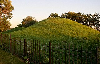
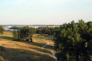
Dayton's Bluff is a neighborhood located on the east side of the Mississippi River in the southeast part of the city of Saint Paul, Minnesota which has a large residential district on the plateau extending backward from its top. The name of the bluff commemorates Lyman Dayton, for whom a city in Hennepin County was also named. On the edge of the southern and highest part of Dayton's Bluff, in Indian Mounds Park, is a series of seven large aboriginal mounds, 4 to 18 feet high, that overlook the river and the central part of the city.

<span class="mw-page-title-main">History of Saint Paul, Minnesota</span> Aspect of history

Saint Paul is the second largest city in the U.S. state of Minnesota, the county seat of Ramsey County, and the state capital of Minnesota. The origin and growth of the city were spurred by the proximity of Fort Snelling, the first major United States military installation in the area, as well as by the city's location on the northernmost navigable port of the Upper Mississippi River.

<span class="mw-page-title-main">Downtown Saint Paul</span> Neighborhood in Ramsey, Minnesota, United States

Downtown Saint Paul is the central business district of Saint Paul, Minnesota, United States. Its boundaries are the Mississippi River to the south, University Avenue to the north, US 52 to the east, and Kellogg Avenue to the west. It is bounded by the Dayton's Bluff, Summit-University, West Seventh, Frogtown, West Side, and Payne-Phalen neighborhoods. The West Side neighborhood is on the other side of the river, and can be accessed via the Robert Street Bridge or the Wabasha Street Bridge. Interstate 35E and Interstate 94 run through the north side of the neighborhood, providing a separation between the Minnesota State Capitol and other state government buildings with the rest of downtown.

<span class="mw-page-title-main">Frogtown, Saint Paul, Minnesota</span> Neighborhood in Ramsey, Minnesota, United States

Frogtown is a neighborhood in Saint Paul in the U.S. state of Minnesota. Built around University Avenue, the Thomas-Dale neighborhood is colloquially known as Frogtown. Historically, Frogtown was a subsection of the current Thomas-Dale neighborhood. It is bordered by University Avenue on the south, the Burlington Northern Railroad tracks to the north, Lexington Parkway on the west and Rice Street on the east.

<span class="mw-page-title-main">Bruce Vento Nature Sanctuary</span>

The Bruce Vento Nature Sanctuary is a city park in the Mississippi River corridor in Saint Paul, Minnesota. Just east of the city's downtown district, the sanctuary includes towering limestone and sandstone bluffs that date back more than 450 million years, spring-fed wetlands, abundant bird life, and dramatic views of the downtown Saint Paul skyline and Mississippi River. The park was opened to the public on May 21, 2005, and was named after its early supporter U.S. Representative Bruce Vento.

<span class="mw-page-title-main">West Seventh, Saint Paul</span> Neighborhood in Ramsey, Minnesota, United States

West Seventh is a neighborhood and city district in Saint Paul, Minnesota. It comprises three smaller neighborhoods: from west to east, the West End, Uppertown, and Irvine Park. The neighborhood lies at the base of Summit Hill and along the Mississippi River's western bluffs, spanning the entire length of West 7th Street. It is also known as Old Fort Road and the Fort Road area. The street follows a historic Native American and fur trader path along the river from downtown Saint Paul to Fort Snelling.

<span class="mw-page-title-main">Selby Avenue</span> Street in Saint Paul, Minnesota

Selby Avenue is a street in Saint Paul, Minnesota, United States, that runs east–west from Summit Avenue near downtown toward the Mississippi River. The street runs through the Summit-University and Union Park neighborhoods. The street, especially between Dale Street and Snelling Avenue, has been associated with Saint Paul's black community. The far eastern end of the street has historically been more densely developed and architecturally significant.

<span class="mw-page-title-main">Union Park, Saint Paul</span> Neighborhood in Ramsey, Minnesota, United States

Union Park is a neighborhood in Saint Paul in the U.S. state of Minnesota. Created as a merger of several historic neighborhoods including Merriam Park, Snelling-Hamline, Parts of Midway, Densoyer Park, and Lexington-Hamline, it is bordered by University Avenue on the north, Lexington Parkway on the east, Summit Avenue on the south, and the Mississippi National River and Recreation Area on the west. Despite the merger, many of the historic neighborhoods hold onto their original identity, especially in Lexington-Hamline and Merriam Park.

<span class="mw-page-title-main">Metro A Line (Minnesota)</span> Bus rapid transit line in the Minneapolis metropolitan area of the United States

The Metro A Line is a bus rapid transit line in the Twin Cities, Minnesota operated by Metro Transit. The A Line operates primarily along the Snelling Avenue corridor and travels through the cities of Minneapolis, Saint Paul, Falcon Heights, and Roseville. From the Blue Line in Minneapolis, the line travels past Minnehaha Park, through the Highland Village commercial area, past Macalester College, and connects to the Green Line near Allianz Field. The line continues through Saint Paul, past Hamline University, before traveling through Falcon Heights and Roseville, where the line passes the Minnesota State Fairgrounds, Har Mar Mall, and terminates at Rosedale Center.

<span class="mw-page-title-main">Mississippi Gorge Regional Park</span> Urban park in Minnesota, United States

Mississippi Gorge Regional Park is a regional park along the east and west bluffs of the Mississippi River in the cities of Minneapolis and Saint Paul in the U.S. state of Minnesota. The two-city park area is between Mississippi river miles 848 and 852, from just south of Northern Pacific Bridge Number 9 to just north of Minnehaha Regional Park, and lies within the Mississippi National River and Recreation Area. The park area protects scenic and natural areas of the Mississippi River gorge, the only true gorge along the entire length of the 2,320-mile (3,730 km) river.

References

  1. McClure, Jane (2007-09-26). "LMV report seeks more support and supervision for city's district councils". Villager . 55 (9): 1, 2.
  2. Nelson, Tim (2007-09-11). "Report: Councils 'Need Some Help' Citizen Group Makes Recommendations". Saint Paul Pioneer Press. pp. B3 Local.
  3. Medcalf, Myron P. (2007-09-11). "St. Paul's neighborhood councils scrutinize their financial status". Star Tribune. pp. B4 Local.
  4. "Saint Paul Participation". Citizen Participation Project Case Studies. Citizen Participation Project. Archived from the original on 2007-12-09. Retrieved 2007-11-10.
  5. 1 2 3 The Street Where You Live, a guide to the place names in St. Paul, Donald L. Simpson, University of Minnesota Press, 111 Third Ave So. Minneapolis, Mn, 2006, p. 88, 285
  6. 1 2 Kunz, Virginia B. (1979). Discover Saint Paul. Ramsey County Historical Society. pp. 29–30.
  7. "Dayton's Bluff History Archived 2007-10-25 at the Wayback Machine ". Dayton's Bluff District Council. Retrieved on August 14, 2008
  8. Kunz, Virginia B. (1979). Discover Saint Paul. Ramsey County Historical Society. p. 5.
  9. Kunz, Virginia B. (1979). Discover Saint Paul. Ramsey County Historical Society. pp. 8–9.
  10. Lehman, Christopher P. (2019). Slavery's reach : Southern slaveholders in the North Star State. Saint Paul, MN: Minnesota Historical Society Press. p. 54. ISBN   9781681341354.
  11. "Frogtown or Thomas Dale". Ramsey County Historical Society. Archived from the original on 2008-04-11. Retrieved 2008-07-22.
  12. "Census Facts" (PDF). Wilder Research Center. Retrieved 8 February 2013.
  13. Martin, Judith A.; Goddard, Antony (1989). Past Choices/Present Landscapes: The Impact of Urban Renewal on the Twin Cities. University of Minnesota Center for Urban and Regional Affairs. pp. 102–103.
  14. "Rondo Neighborhood & the Building of I-94". Minnesota Historical Society . Retrieved 8 February 2013.
  15. Millett, Larry (2009). AIA guide to St. Paul's Summit Avenue and Hill District. St. Paul, MN: Minnesota Historical Society Press. p. 84. ISBN   978-0-87351-644-0.
  16. Elizabeth Caperton-Halvorson (2006). Newcomer's Handbook for Moving to and Living in Minneapolis - St. Paul (Newcomer's Handbooks). First Books Inc. pp. 65–66. ISBN   0-912301-67-8.
  17. Kunz, Virginia B. (1979). Discover Saint Paul. Ramsey County Historical Society. p. 23.
  18. 1 2 City of St. Paul Website: http://www.stpaul.gov/index.aspx?NID=1859
  19. Twenty-five Years of Facing Change: West 7th/Fort Road Federation 1973-1998
  20. "Minnesota House of Representatives - Members".
  21. "America's Top Public High Schools". The complete list of the 1,300 top U.S. schools. MSNBC. 2007. Archived from the original on 2007-07-09. Retrieved 2007-07-30.
  22. 1 2 Empson, Donald; Boxmeyer, Don (2006). The Street Where You Live: A Guide to the Place Names of St. Paul . Univ Of Minnesota Press. ISBN   978-0-8166-4729-3.
  23. Thornley, Stew (2006). Baseball in Minnesota: the definitive history. St. Paul, MN: Minnesota Historical Society Press. pp. xi. ISBN   978-0-87351-551-1.
  24. City Pages and 89.3 The Current present HEIRUSPECS CD Release Show First Avenue.
  25. "Profile of Saint Paul's historic St. Anthony neighborhood". www.rchs.com. Archived from the original on 2006-10-18.
  26. Midway : A Vision for an Urban Center February 25, 2003 University UNITED.
  27. "A Tale of Two Cities". 18 April 2019.
  28. Berg, Steve (Nov. 15, 2007) "Urban designers critique Minneapolis and offer this idea: Tear down all those horrible skyways" MinnPost