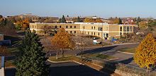
Fridley is a city in Anoka County, Minnesota, United States. Its population was 29,590 at the 2020 census. Fridley was incorporated in 1949 as a village, and became a city in 1957. It is part of the Minneapolis–Saint Paul metropolitan area as a "first-ring" or "inner-ring" suburb its northern part. Fridley borders Minneapolis to the southwest. Neighboring first-ring suburbs are Columbia Heights to the south and Brooklyn Center to the west, across the Mississippi River.
Burnsville is a city 15 miles (24 km) south of downtown Minneapolis in Dakota County, Minnesota. The city is situated on a bluff overlooking the south bank of the Minnesota River, upstream from its confluence with the Mississippi River. Burnsville and nearby suburbs form the southern portion of Minneapolis–Saint Paul, the 16th-largest metropolitan area in the United States, with about 3.7 million residents. At the 2020 census the population was 64,317.

The Metropolitan Council, commonly abbreviated Met Council or Metro Council, is the regional governmental agency and metropolitan planning organization in Minnesota serving the Twin Cities seven-county metropolitan area, accounting for over 55 percent of the state's population. It is one of two multi-county regional governments in the United States, the other being the Portland Metro.

The Northstar Line is a commuter rail route in the US state of Minnesota. Northstar runs 40 miles (64 km) from Big Lake to downtown Minneapolis at Target Field using existing track and right-of-way owned by the BNSF Railway. Passenger service began on November 16, 2009. The rail line serves part of the Northstar Corridor between Minneapolis and St. Cloud. Planning for the line began in 1997 when the Northstar Corridor Development Authority (NCDA) was formed. The corridor is also served by Interstate 94 and U.S. Highway 10. In 2022, the system had a ridership of 77,100, or about 400 per weekday as of the fourth quarter of 2022.

Whittier is a neighborhood within the Powderhorn community in the U.S. city of Minneapolis, Minnesota, bounded by Franklin Avenue on the north, Interstate 35W on the east, Lake Street on the south, and Lyndale Avenue on the west. It is known for its many diverse restaurants, coffee shops and Asian markets, especially along Nicollet Avenue. The neighborhood is home to the Minneapolis Institute of Art, the Minneapolis College of Art and Design, and the Children's Theatre Company.
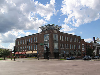
A festival marketplace is a European-style shopping market in the United States. It is an effort to revitalize downtown areas in major US cities begun in the late 20th century.

Cray Plaza, located in the Lowertown neighborhood of Saint Paul, Minnesota, United States, provides space for working, living, eating, and recreating on one square city block opened in 1986.

Bandana Square, formerly the Como Shops of the Northern Pacific Railway, is currently an office center. However, it was initially designed to be an Shopping Mall in the Energy Park neighborhood of Saint Paul, Minnesota. The site is on the National Register of Historic Places

Minneapolis, officially the City of Minneapolis, is a city in the state of Minnesota and the county seat of Hennepin County. As of the 2020 census the population was 429,954, making it the largest city in Minnesota and the 46th-most-populous in the United States. Nicknamed the "City of Lakes", Minneapolis is abundant in water, with thirteen lakes, wetlands, the Mississippi River, creeks, and waterfalls. Minneapolis has its origins as the 19th century lumber and flour milling capitals of the world, and, to the present day, preserved its financial clout. It occupies both banks of the Mississippi River and adjoins Saint Paul, the state capital of Minnesota.

Saint Anthony Park is a neighborhood in northwest Saint Paul, Minnesota. It is adjacent to the University of Minnesota's St. Paul Campus, bordering Southeast Minneapolis on the west, the Minnesota State Fairgrounds on the east, and the suburbs of Falcon Heights and Lauderdale to the north.
The U of M Transitway is a busway that runs between the University of Minnesota's Minneapolis and St. Paul campuses. Use of the roadway is limited to buses, bicycles, and emergency vehicles. The University of Minnesota runs zero-fare buses along the busway connecting the two campuses, primarily the Campus Connector but also shuttles to and from the St. Paul campus for football games. A bicycle trail runs alongside the transitway for most of its distance. Between the endpoints, there are only two intersections with stoplights controlling busway traffic at Energy Park Drive and Como Avenue. The stoplights are designed to normally give the buses priority, so it is possible for many buses to run the length of the transitway without stopping.
The Northern Lights Express (NLX) is a planned higher-speed rail service that would run 155 miles (249 km) between Minneapolis and Duluth primarily in the U.S. state of Minnesota. A portion of the proposed line would run through neighboring Wisconsin to serve Duluth's "Twin Port" of Superior. Plans are to upgrade an existing BNSF Railway freight line to allow trains to travel at up to 90 miles per hour (145 km/h). The train service is said to provide an alternative to traveling Interstate 35 between Duluth and the Twin Cities or to other destinations along the line such as the casino in Hinckley.

Downtown Saint Paul is the central business district of Saint Paul, Minnesota, United States. Its boundaries are the Mississippi River to the south, University Avenue to the north, US 52 to the east, and Kellogg Avenue to the west. It is bounded by the Dayton's Bluff, Summit-University, West Seventh, Frogtown, West Side, and Payne-Phalen neighborhoods. The West Side neighborhood is on the other side of the river, and can be accessed via the Robert Street Bridge or the Wabasha Street Bridge. Interstate 35E and Interstate 94 run through the north side of the neighborhood, providing a separation between the Minnesota State Capitol and other state government buildings with the rest of downtown.
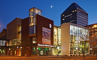
The Minnesota Children's Museum is a children's museum in Saint Paul, Minnesota. Founded in 1981 in Minneapolis, the museum moved to St. Paul in 1995.

Frogtown is a neighborhood in Saint Paul in the U.S. state of Minnesota. Built around University Avenue, the Thomas-Dale neighborhood is colloquially known as Frogtown. Historically, Frogtown was a subsection of the current Thomas-Dale neighborhood. It is bordered by University Avenue on the south, the Burlington Northern Railroad tracks to the north, Lexington Parkway on the west and Rice Street on the east.

Selby Avenue is a street in Saint Paul, Minnesota, United States, that runs east–west from Summit Avenue near downtown toward the Mississippi River. The street runs through the Summit-University and Union Park neighborhoods. The street, especially between Dale Street and Snelling Avenue, has been associated with Saint Paul's black community. The far eastern end of the street has historically been more densely developed and architecturally significant.

The Unidale Mall is a shopping mall located at the intersection of University Avenue and Dale Street in Saint Paul, Minnesota, United States. The mall is in the Summit-University neighborhood just across from the Frogtown neighborhood. The Rondo Community Outreach Library is west across Dale Street. The Dale Street station on the Green Line is also at the intersection.

Como Regional Park Pool or just Como Pool is a public swimming pool located in the Como Park neighborhood of Saint Paul, Minnesota.
The Dorothy Day shelter is a homeless shelter campus in Saint Paul, Minnesota, United States. The project is centered around the site of the Dorothy Day Center built in downtown Saint Paul in 1981. The shelter is named after American Catholic and social activist Dorothy Day. The Dorothy Day Center started as a drop-in center for meals to help the homeless population in downtown Saint Paul. The facility is operated by Catholic Charities of St. Paul and Minneapolis in coordination with Ramsey County, Minnesota.

TRIA Rink is an ice hockey arena and practice facility in Saint Paul, Minnesota. It is located on the fifth floor of Treasure Island Center, a former Macy’s department store in downtown St. Paul. The arena was constructed as part of a redevelopment effort by the Saint Paul Port Authority who is redeveloping the building. The arena is the practice facility of the Minnesota Wild of the National Hockey League and the former home arena of the Minnesota Whitecaps of the Premier Hockey Federation and Hamline University's hockey program.