
Saint Paul is the capital of the U.S. state of Minnesota and the county seat of Ramsey County. Situated on high bluffs overlooking a bend in the Mississippi River, Saint Paul is a regional business hub and the center of Minnesota's government. The Minnesota State Capitol and the state government offices all sit on a hill close to the city's downtown district. One of the oldest cities in Minnesota, Saint Paul has several historic neighborhoods and landmarks, such as the Summit Avenue Neighborhood, the James J. Hill House, and the Cathedral of Saint Paul. Like the adjacent city of Minneapolis, Saint Paul is known for its cold, snowy winters and humid summers.

Fort Snelling is a former military fortification and National Historic Landmark in the U.S. state of Minnesota on the bluffs overlooking the confluence of the Minnesota and Mississippi Rivers. The military site was initially named Fort Saint Anthony, but it was renamed Fort Snelling once its construction was completed in 1825.

Minnesota State Highway 5 is a 76.347-mile-long (122.869 km) highway in Minnesota, which runs from its intersection with MN 19 and MN 22 in Gaylord and continues east and northeast to its eastern terminus at its intersection with MN 120 in Maplewood. The route passes through downtown Saint Paul.

University Avenue is a street that runs through both Minneapolis and Saint Paul, Minnesota. It begins near the Minnesota State Capitol in Saint Paul and extends westward into neighboring Minneapolis, where it passes the University of Minnesota, and then turns north to pass through several suburbs before its main portion ends in Blaine, Minnesota, although there are stretches of road designated as University Avenue that are north of the Blaine terminus, the final stretch ending near Andree, Minnesota. For many years, the road carried U.S. Highway 12 and U.S. Highway 52, and University Avenue is still a significant thoroughfare in the area.

The Mississippi National River and Recreation Area is a 72-mile (116 km) and 54,000-acre (22,000 ha) protected corridor along the Mississippi River through the Minneapolis–Saint Paul metro in the U.S. state of Minnesota, from the cities of Dayton and Ramsey, to just downstream of Hastings. This stretch of the upper Mississippi River includes natural, historical, recreational, cultural, scenic, scientific, and economic resources of national significance. This area is the only national park site dedicated exclusively to the Mississippi River. The Mississippi National River and Recreation Area is sometimes abbreviated as MNRRA or MISS, the four letter code assigned to the area by the National Park Service. The Mississippi National River and Recreation Area is classified as one of four national rivers in the United States, and despite its name it is technically not one of the 40 national recreation areas.

Minnesota State Highway 51 is a 11.274-mile-long (18.144 km) highway in Minnesota, which runs from its intersection with State Highway 5 in Saint Paul and continues north to its northern terminus at its interchange with Interstate 694 / U.S. Highway 10 in Arden Hills.

Highland Park is a neighborhood in the southwestern corner of Saint Paul, Minnesota, United States. Also known as Highland District Council, it lies along the Mississippi River just north of Fort Snelling and across the river from Minneapolis–Saint Paul International Airport. According to the 2000 census Highland Park had a population of 23,202.
The Riverview Corridor is a transit corridor connecting Downtown Saint Paul and the Mall of America in Bloomington via the Minneapolis-Saint Paul International Airport. The corridor serves an area from the Saint Paul Union Depot to the Mall via a route along West 7th Street, which runs southwest from Downtown Saint Paul. The corridor creates a triangle connecting opposite ends of the Blue Line and Green Line.
In addition to the proposed transit projects in the Twin Cities region, there have been some transit corridors that are no longer proposed.

Shepard Road and Warner Road are the names given to a four-lane road running along the banks of the Mississippi River in Saint Paul, Minnesota. Shepard Road runs from the southwestern boundary of the county to downtown Saint Paul. From downtown east the road is known as Warner Road (County Road 36; it runs to a junction with US Highways 61 and 10.

Irvine Park is a neighborhood just west of downtown Saint Paul, Minnesota, United States, that contains a number of historic homes. The neighborhood was platted by John Irvine and Henry Mower Rice in 1849. At the center of the neighborhood is Irvine Park, a New England–style public square. The neighborhood is a district listed on the National Register of Historic Places and also designated by the city as a historic district.

Saint Paul, Minnesota, consists of 17 officially defined city districts or neighborhoods.
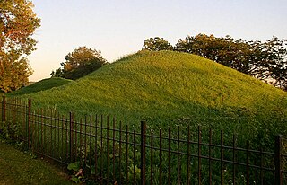
Dayton's Bluff is a neighborhood located on the east side of the Mississippi River in the southeast part of the city of Saint Paul, Minnesota which has a large residential district on the plateau extending backward from its top. The name of the bluff commemorates Lyman Dayton, for whom a city in Hennepin County was also named. On the edge of the southern and highest part of Dayton's Bluff, in Indian Mounds Park, is a series of seven large aboriginal mounds, 4 to 18 feet high, that overlook the river and the central part of the city.

Saint Paul is the second largest city in the U.S. state of Minnesota, the county seat of Ramsey County, and the state capital of Minnesota. The origin and growth of the city were spurred by the proximity of Fort Snelling, the first major United States military installation in the area, as well as by the city's location on the northernmost navigable port of the Upper Mississippi River.

Until recently, the limestone building at 445 Smith Avenue North, St. Paul, Minnesota, United States, was known in surveys and local architectural history books as the Anthony Waldman House. However, recent research and analysis of the building has revealed that the Waldman House was not in fact built by Waldman, and was not originally a "house" either. Instead, the structure was a small commercial building with residential quarters on the second floor. Evidence of this commercial design include a side porch/loading dock facing the alley to the north ; obvious stone in-filling of the first-floor shop-front windows; a large structural beam above the one-time shop front that supported the second-story stonework; photographic evidence from the 1940s of remnants of the original first-floor commercial cornice ; physical evidence of a central entrance step into the shop; and wooden sleepers that served as nailers for decorative wooden pilasters or perhaps signs at either side of the shop windows below the cornice. Documentary evidence suggests that the stone portion of the building dates to the late fall of 1857, coinciding with the onset of the Panic of 1857. Another unexpected discovery is that parts of the wood frame addition to the rear of the stone building actually predate the stone portion, making the latter the true "addition." The research is ongoing, and no doubt the Waldman House has more stories to tell.

Metro is a transit network in Minnesota serving the cities of Minneapolis and Saint Paul. It also provides service to some suburban areas. As of 2022, the system consists of two light rail lines and five bus rapid transit (BRT) lines all of which are operated by the local public transit company: Metro Transit. The five lines connect Downtown Minneapolis and St Paul with the Bloomington, Minneapolis-St Paul International Airport, Roseville, Richfield, Burnsville and Brooklyn Center.

Selby Avenue is a street in Saint Paul, Minnesota, United States, that runs east–west from Summit Avenue near downtown toward the Mississippi River. The street runs through the Summit-University and Union Park neighborhoods. The street, especially between Dale Street and Snelling Avenue, has been associated with Saint Paul's black community. The far eastern end of the street has historically been more densely developed and architecturally significant.

Union Park is a neighborhood in Saint Paul in the U.S. state of Minnesota. Created as a merger of several historic neighborhoods including Merriam Park, Snelling-Hamline, Parts of Midway, Densoyer Park, and Lexington-Hamline, it is bordered by University Avenue on the north, Lexington Parkway on the east, Summit Avenue on the south, and the Mississippi National River and Recreation Area on the west. Despite the merger, many of the historic neighborhoods hold onto their original identity, especially in Lexington-Hamline and Merriam Park.

The Metro A Line is a bus rapid transit line in the Twin Cities, Minnesota operated by Metro Transit. The A Line operates primarily along the Snelling Avenue corridor and travels through the cities of Minneapolis, Saint Paul, Falcon Heights, and Roseville. From the Blue Line in Minneapolis, the line travels past Minnehaha Park, through the Highland Village commercial area, past Macalester College, and connects to the Green Line near Allianz Field. The line continues through Saint Paul, past Hamline University, before traveling through Falcon Heights and Roseville, where the line passes the Minnesota State Fairgrounds, Har Mar Mall, and terminates at Rosedale Center.


