Related Research Articles

Saint Paul is the capital of the U.S. state of Minnesota and the county seat of Ramsey County. Situated on high bluffs overlooking a bend in the Mississippi River, Saint Paul is a regional business hub and the center of Minnesota's government. The Minnesota State Capitol and the state government offices all sit on a hill close to the city's downtown district. One of the oldest cities in Minnesota, Saint Paul has several historic neighborhoods and landmarks, such as the Summit Avenue Neighborhood, the James J. Hill House, and the Cathedral of Saint Paul. Like the adjacent city of Minneapolis, Saint Paul is known for its cold, snowy winters and humid summers.

Minneapolis–Saint Paul is a metropolitan area in the Upper Midwestern United States centered around the confluence of the Mississippi, Minnesota and St. Croix rivers in the U.S. state of Minnesota. It is commonly known as the Twin Cities after the area's two largest cities, Minneapolis and Saint Paul. Minnesotans often refer to the two together simply as "the cities". The area is Minnesota's economic, cultural, and political center.

The Metro Green Line is an 11-mile (18 km) light rail line that connects the central business districts of Minneapolis and Saint Paul in Minnesota as well as the University of Minnesota. An extension is under construction that will extend the line to the southwest connecting St. Louis Park, Hopkins, Minnetonka and Eden Prairie. The line follows the path of former Metro Transit bus route 16 along University Avenue and Washington Avenue. It is the second light-rail line in the region, after the Blue Line, which opened in 2004 and connects Minneapolis with the southern suburb of Bloomington.

Midway Stadium was the name of two different minor league baseball parks in Saint Paul, Minnesota, United States, both now demolished. The name derived from the location of the stadium in Saint Paul's Midway area, so named because it is roughly halfway between the downtowns of Minneapolis and Saint Paul.

University Avenue is a street that runs through both Minneapolis and Saint Paul, Minnesota. It begins near the Minnesota State Capitol in Saint Paul and extends westward into neighboring Minneapolis, where it passes the University of Minnesota, and then turns north to pass through several suburbs before its main portion ends in Blaine, Minnesota, although there are stretches of road designated as University Avenue that are north of the Blaine terminus, the final stretch ending near Andree, Minnesota. For many years, the road carried U.S. Highway 12 and U.S. Highway 52, and University Avenue is still a significant thoroughfare in the area.

Minnesota State Highway 51 is a 11.274-mile-long (18.144 km) highway in Minnesota, which runs from its intersection with State Highway 5 in Saint Paul and continues north to its northern terminus at its interchange with Interstate 694 / U.S. Highway 10 in Arden Hills.
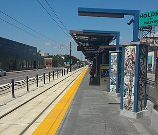
Snelling Avenue station is a light rail station along the Metro Green Line in Saint Paul, Minnesota. It is located along University Avenue on either side of the intersection with Snelling Avenue. The station has split side platforms, with the westbound platform on the north side of the tracks west of Snelling and the eastbound platform on the south side of the tracks east of the intersection.

Minneapolis is the largest city by population in the U.S. state of Minnesota, and the county seat of Hennepin County. The origin and growth of the city was spurred by the proximity of Fort Snelling, the first major United States military presence in the area, and by its location on Saint Anthony Falls, which provided power for sawmills and flour mills.

Ayd Mill Road ( EYEDMILL is a road in Saint Paul, Minnesota. It runs diagonally through Saint Paul, connecting with Interstate 35E at its southeast terminus, and feeds into Selby Avenue at its northwest end. Indirect access to I-94 is possible via Selby and Snelling Avenues. Originally known as the Short Line Road, it was renamed in 1987 for John Ayd, a German settler who maintained a mill and residence in the area in the mid-to-late 19th century.
The Riverview Corridor is a transit corridor connecting Downtown Saint Paul and the Mall of America in Bloomington via the Minneapolis-Saint Paul International Airport. The corridor serves an area from the Saint Paul Union Depot to the Mall via a route along West 7th Street, which runs southwest from Downtown Saint Paul. The corridor creates a triangle connecting opposite ends of the Blue Line and Green Line.

Saint Paul, Minnesota, consists of 17 officially defined city districts or neighborhoods.

Downtown Saint Paul is the central business district of Saint Paul, Minnesota, United States. Its boundaries are the Mississippi River to the south, University Avenue to the north, US 52 to the east, and Kellogg Boulevard to the west. It is bounded by the Dayton's Bluff, Summit-University, West Seventh, Frogtown, West Side, and Payne-Phalen neighborhoods. The West Side neighborhood is on the other side of the river, and can be accessed via the Robert Street Bridge or the Wabasha Street Bridge. Interstate 35E and Interstate 94 run through the north side of the neighborhood, providing a separation between the Minnesota State Capitol and other state government buildings with the rest of downtown.

Metro is a transit network in Minnesota serving the cities of Minneapolis and Saint Paul. It also provides service to some suburban areas. As of 2022, the system consists of two light rail lines and five bus rapid transit (BRT) lines all of which are operated by the local public transit company: Metro Transit. The five lines connect Downtown Minneapolis and St Paul with the Bloomington, Minneapolis-St Paul International Airport, Roseville, Richfield, Burnsville and Brooklyn Center.

Selby Avenue is a street in Saint Paul, Minnesota, United States, that runs east–west from Summit Avenue near downtown toward the Mississippi River. The street runs through the Summit-University and Union Park neighborhoods. The street, especially between Dale Street and Snelling Avenue, has been associated with Saint Paul's black community. The far eastern end of the street has historically been more densely developed and architecturally significant.

Union Park is a neighborhood in Saint Paul in the U.S. state of Minnesota. Created as a merger of several historic neighborhoods including Merriam Park, Snelling-Hamline, Parts of Midway, Densoyer Park, and Lexington-Hamline, it is bordered by University Avenue on the north, Lexington Parkway on the east, Summit Avenue on the south, and the Mississippi National River and Recreation Area on the west. Despite the merger, many of the historic neighborhoods hold onto their original identity, especially in Lexington-Hamline and Merriam Park.

Allianz Field is a soccer-specific stadium in Saint Paul, Minnesota, home to Minnesota United FC of Major League Soccer (MLS). Opening in 2019, the 19,400-seat stadium was designed by Populous, during the club's third MLS season. It is located near Interstate 94 and Snelling Avenue.

The Metro A Line is a bus rapid transit line in the Twin Cities, Minnesota operated by Metro Transit. The A Line operates primarily along the Snelling Avenue corridor and travels through the cities of Minneapolis, Saint Paul, Falcon Heights, and Roseville. From the Blue Line in Minneapolis, the line travels past Minnehaha Park, through the Highland Village commercial area, past Macalester College, and connects to the Green Line near Allianz Field. The line continues through Saint Paul, past Hamline University, before traveling through Falcon Heights and Roseville, where the line passes the Minnesota State Fairgrounds, Har Mar Mall, and terminates at Rosedale Center.

The Metro B Line is an under construction bus rapid transit route in Minneapolis and St. Paul. The route will operate mostly on Lake Street in Minneapolis before crossing the Mississippi River into St. Paul and operating mostly on Selby Avenue and ending in downtown St. Paul. The route was identified in Metro Transit's 2014 Arterial Transitway Corridors Study as one of eleven local routes to be upgraded to bus rapid transit. The route will have "train-like" features to speed up service, such as signal priority, all-door boarding, further stop spacing, and specialized vehicles. Planning and design was completed in 2021, with construction beginning in May 2023. The line will join a number of Metro Transit's future Metro system lines, as well as the currently operating A Line, C Line, and D Line. Full funding for the line was secured in October 2020 with a final $35 million from the state of Minnesota.
The Spruce Tree Centre is a building in Saint Paul, Minnesota in the US. Located at the intersection of University Avenue and Snelling Avenues, the 126,000 square feet (11,700 m2) building was built in 1988. An attached parking garage has over 350 spaces. The parking garage is owned by the city of Saint Paul and has electric car chargers. The building replaced a drug store built in the 1920s.
References
- ↑ Hamline Midway Community Plan Retrieved on February 2nd, 2024
- ↑ Heilman, Dan (13 December 2017). "Midway area is St. Paul's quiet giant | Finance & Commerce". Finance & Commerce . Retrieved 6 May 2024.
- 1 2 3 4 5 Millett, Larry (2007). AIA guide to the Twin Cities: the essential source on the architecture of Minneapolis and St. Paul. St. Paul: Minnesota Historical Society Press. pp. 562–568. ISBN 9780873515405.
- ↑ Martin, Judith A.; Lanegran, David A. (1983). Where We Live. The Residential Districts of Minneapolis and Saint Paul. University of Minnesota Press. pp. 5, 83, 126. ISBN 0816610940.
- ↑ Martin, Judith A.; Goddard, Antony (1989). Past Choices/Present Landscapes: The Impact of Urban Renewal on the Twin Cities. University of Minnesota Center for Urban and Regional Affairs.
- 1 2 Meryhew, Richard; Ison, Chris (May 4, 1987). "Wave of redevelopment hits St. Paul's Midway". pp. 15A, 17A . Retrieved May 10, 2024– via Newspapers.com.
- ↑ "Hamline-Midway | CURA Twin Cities Gentrification Project". gentrification.umn.edu. Center for Urban and Regional Affairs. January 25, 2019. Retrieved 6 May 2024.
- ↑ "How the construction of the Green Line altered the path of St. Paul's Central Corridor and what we can learn from it". kare11.com. 15 March 2023. Retrieved 6 May 2024.
- ↑ Lindeke, Bill (8 April 2022). "What's next after the death of the Midway CVS". MinnPost . Retrieved 6 May 2024.
- ↑ Melo, Frederick (7 April 2019). "Allianz Field is just the beginning. Here's what's happening — and hoped for — around St. Paul's new soccer stadium". St. Paul Pioneer Press . Retrieved 6 May 2024.
- ↑ Cox, Peter (12 August 2015). "Residents worry as pro soccer eyes St. Paul Midway site". MPR News. Retrieved 6 May 2024.
- ↑ Kaul, Greta; Walsh, James (March 8, 2024). "St. Paul's Midway neighborhood still waiting for renaissance around Allianz Field". Star Tribune. Retrieved 6 May 2024.