West St. Paul, Minnesota

Last updated

West St. Paul
City of West St. Paul
West St. Paul, MN.jpg
Nickname: 
W.S.P.
Motto: 
"We're Close To It All"
Dakota County Minnesota Incorporated and Unincorporated areas West St. Paul Highlighted.svg
Location of the city of West St. Paul
within Dakota County, Minnesota
Coordinates: 44°54′58″N93°06′06″W / 44.91611°N 93.10167°W / 44.91611; -93.10167
CountryUnited States
State Minnesota
County Dakota
Founded1858
Incorporated February 23, 1889
Government
   Mayor Dave Napier
Area
[1]
  Total5.01 sq mi (12.98 km2)
  Land4.91 sq mi (12.71 km2)
  Water0.10 sq mi (0.27 km2)
Elevation
[2]
1,027 ft (313 m)
Population
 (2020) [3]
  Total20,615
  Estimate 
(2022) [4]
21,794
  Density4,200.29/sq mi (1,621.70/km2)
Time zone UTC-6 (Central (CST))
  Summer (DST) UTC-5 (CDT)
ZIP code
55118
Area code 651
FIPS code 27-69700
GNIS feature ID654003 [2]
Sales tax 8.625% [5]
Website wspmn.gov

West St. Paul is a city in Dakota County, Minnesota, United States. The population was 20,615 at the 2020 census. [3] It is immediately south of Saint Paul and immediately west of South St. Paul.

Contents

History

The city's misleading name comes in part from the fact that it lies on the west bank of the predominantly north-to-south Mississippi River. A previous City of West St. Paul, incorporated in the late 19th century, was situated in what is now called Saint Paul's Lower West Side. According to the West 7th/Fort Road foundation, Saint Paul annexed the West Side, and was incorporated for two reasons: "to aid law enforcement—criminals could escape Saint Paul authorities by crossing to the West Side and Dakota County—and to eliminate the Wabasha Street Bridge tolls which were inhibiting development on the West Side."[ citation needed ] The current West St. Paul split from the western half of South St. Paul, and was incorporated in 1889, just south of the city of Saint Paul. The population was 20,615 at the 2020 census, [3] growing by 1,075 since 2010 census. West Saint Paul is known for its 2.5-mile retail strip along Robert Street.

Geography

According to the United States Census Bureau, the city has a total area of 5.01 square miles (12.98 km2), of which 4.91 square miles (12.72 km2) is land and 0.10 square miles (0.26 km2) is water. [6]

U.S. Highway 52 (also known as the Lafayette Freeway), Robert Street, and Minnesota Highway 62 are three of West St. Paul's main routes. Interstate Highway 494 runs just south of the city and Minnesota Highway 3 (unmarked Route 952) runs through the middle of the city and into downtown Saint Paul as Robert Street. Robert Street was named for Captain Louis Robert, a Mississippi River boat captain and early French-Canadian settler of Saint Paul.

Demographics

Historical population
CensusPop.Note
1890 1,596
1900 1,83014.7%
1910 2,66045.4%
1920 2,96211.4%
1930 4,46350.7%
1940 5,73328.5%
1950 7,95538.8%
1960 13,10164.7%
1970 18,80243.5%
1980 18,527−1.5%
1990 19,2483.9%
2000 19,4050.8%
2010 19,5400.7%
2020 20,6155.5%
2022 (est.)21,794 [4] 5.7%
U.S. Decennial Census [7]
2020 Census [3]

2010 census

As of the census of 2010, there were 19,540 people, 8,529 households, and 4,751 families living in the city. The population density was 3,979.6 inhabitants per square mile (1,536.5/km2). There were 9,139 housing units at an average density of 1,861.3 per square mile (718.7/km2). The racial makeup of the city was 78.0% White, 6.0% African American, 0.9% Native American, 2.2% Asian, 0.1% Pacific Islander, 8.6% from other races, and 4.3% from two or more races. Hispanic or Latino of any race were 19.5% of the population.

There were 8,529 households, of which 27.2% had children under the age of 18 living with them, 38.8% were married couples living together, 12.3% had a female householder with no husband present, 4.7% had a male householder with no wife present, and 44.3% were non-families. 37.6% of all households were made up of individuals, and 15.1% had someone living alone who was 65 years of age or older. The average household size was 2.25 and the average family size was 3.00.

The median age in the city was 39.7 years. 22.3% of residents were under the age of 18; 7.8% were between the ages of 18 and 24; 26.4% were from 25 to 44; 26.4% were from 45 to 64; and 17% were 65 years of age or older. The gender makeup of the city was 47.6% male and 52.4% female.

2000 census

As of the census of 2000, there were 19,405 people, 8,645 households, and 4,875 families living in the city. The population density was 3,874.2 inhabitants per square mile (1,495.8/km2). There were 8,779 housing units at an average density of 1,752.7 per square mile (676.7/km2). The racial makeup of the city was 87.27% White, 2.83% African American, 0.62% Native American, 1.89% Asian, 0.03% Pacific Islander, 4.88% from other races, and 2.49% from two or more races. Hispanic or Latino of any race were 9.98% of the population.

There were 8,645 households, of which 24.6% had children under the age of 18 living with them, 42.4% were married couples living together, 10.7% had a female householder with no husband present, and 43.6% were non-families. 37.1% of all households were made up of individuals, and 15.9% had someone living alone who was 65 years of age or older. The average household size was 2.20 and the average family size was 2.93.

In the city, the population was spread out, with 21.1% under the age of 18, 8.9% from 18 to 24, 28.7% from 25 to 44, 22.1% from 45 to 64, and 19.2% who were 65 years of age or older. The median age was 39 years. For every 100 females, there were 87.3 males. For every 100 females age 18 and over, there were 83.1 males.

The median income for a household in the city was $41,103, and the median income for a family was $56,786. Males had a median income of $39,344 versus $29,836 for females. The per capita income for the city was $23,558. About 3.8% of families and 5.9% of the population were below the poverty line, including 6.6% of those under age 18 and 5.2% of those age 65 or over.

Economy

West St. Paul's major employers include:

Government

Police

The West St. Paul Police Department is made up of approximately 25 sworn officers, including four sergeants, 21 patrol officers and three part-time non-sworn Community Service Officers (CSO) under the command of Chief Brian Sturgeon.

Education

West St. Paul is served by Independent School District 197 public schools and is home to Moreland Arts and Sciences Magnet School (K-4), Garlough Environmental Magnet School (K-4), Heritage E-Stem Magnet School (grades 5-8), and Two Rivers High School (grades 9-12).

Crown of Life Lutheran (K-8) [9] and St. Croix Lutheran Academy High School (6-12) [10] are two Christian schools of the Wisconsin Evangelical Lutheran Synod in West St. Paul.

St. Joseph's Catholic School (K-8) is in West St. Paul.

The Thomas Irvine Dodge Nature Center's West St. Paul location contains nature preserves and a nature education-based preschool. [11]

Notable people

Related Research Articles

<span class="mw-page-title-main">St. Ansgar, Iowa</span> City in Iowa, United States

St. Ansgar is a city in Mitchell County, Iowa, United States. The population was 1,160 at the 2020 census.

<span class="mw-page-title-main">Sleepy Eye, Minnesota</span> City in Minnesota, United States

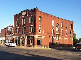
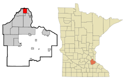
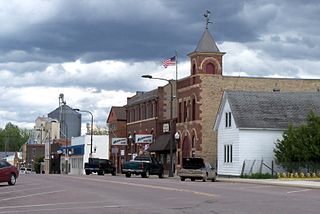
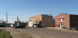
Sleepy Eye is a small city in rural Brown County, Minnesota, United States. The city is named after a famed local Dakota chief from the 1800s. The population was 3,599 at the 2010 census.

<span class="mw-page-title-main">Inver Grove Heights, Minnesota</span> City in Minnesota, United States

Inver Grove Heights is a city in Dakota County, Minnesota, United States. The population was 35,801 at the 2020 census. The city was formed on March 9, 1965, with the merger of the village of Inver Grove and Inver Grove Township.

<span class="mw-page-title-main">South St. Paul, Minnesota</span> City in Minnesota, United States

South St. Paul is a city in Dakota County, Minnesota, United States, immediately south and southeast of St. Paul and east of West St. Paul. The population was 20,759 at the 2020 census. The town was a major meat-packing location, and many residents are descended from immigrants of Southern European and Eastern European heritage, who came to work in the meat-packing plants in the early twentieth century.

<span class="mw-page-title-main">Cannon Falls, Minnesota</span> City in Minnesota, Goodhue County, United States

Cannon Falls is a city in Goodhue County, Minnesota, United States. The population was 4,083 at the 2010 census. Located along U.S. Route 52, southeast of the Twin Cities, Cannon Falls is the home of Pachyderm Studio, where many famous musicians have recorded, including Nirvana, which recorded its 1993 album In Utero there.

<span class="mw-page-title-main">Zumbrota, Minnesota</span> City in Minnesota, United States

Zumbrota is a city in Goodhue County, Minnesota, United States, along the North Fork of the Zumbro River. The population was 3,252 at the 2010 census. It promotes itself as "the only Zumbrota in the world."

<span class="mw-page-title-main">Tyler, Minnesota</span> City in Minnesota, United States

Tyler is a city in Lincoln County, Minnesota, United States. The population of Tyler was 1,143 at the 2010 census.

<span class="mw-page-title-main">Fairmont, Minnesota</span> City in Minnesota, United States

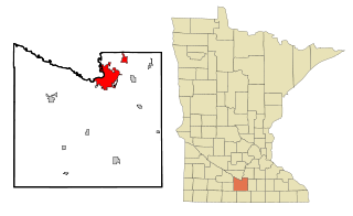
Fairmont is a city and the county seat of Martin County, Minnesota, United States. The population was 10,487 at the 2020 census.

<span class="mw-page-title-main">Fulda, Minnesota</span> City in Minnesota, United States

Fulda is a city in Murray County, Minnesota, United States. The population was 1,371 at the 2020 census, up from 1,318 in 2010.

<span class="mw-page-title-main">North St. Paul, Minnesota</span> City in Minnesota, United States

North Saint Paul is a city in Ramsey County, Minnesota, United States, located east-northeast of the city of Saint Paul. The population was 12,364 at the 2020 census.

<span class="mw-page-title-main">Roseville, Minnesota</span> City in Minnesota, United States

Roseville is a city in Ramsey County, Minnesota, United States. It is one of two Twin Cities suburbs that are adjacent to both Saint Paul and Minneapolis. Roseville comprises Falcon Heights, Lauderdale, and southern Roseville. The latter was unincorporated until Roseville incorporated in 1948, and Falcon Heights and Lauderdale incorporated in 1949. The population was 36,254 at the 2020 census.

<span class="mw-page-title-main">Arlington, Minnesota</span> City in Minnesota, United States

Arlington is a city in Sibley County, Minnesota, United States. The population was 2,233 at the 2010 census.

<span class="mw-page-title-main">Scandia, Minnesota</span> City in Minnesota, United States

Scandia is a city in Washington County, Minnesota, United States. The population was 3,984 at the 2020 census. Scandia is 25 miles northeast of Saint Paul, Minnesota.

<span class="mw-page-title-main">Stillwater, Minnesota</span> City in Minnesota, United States

Stillwater is a city in the U.S. state of Minnesota and the county seat of Washington County. It is in the Minneapolis–Saint Paul metropolitan area, on the west bank of the St. Croix River, across from Houlton, Wisconsin. Stillwater's population was 19,394 at the 2020 census. Stillwater is often called "the birthplace of Minnesota" due to its role in the establishment of the state.

<span class="mw-page-title-main">Lewiston, Minnesota</span> City in Minnesota, United States

Lewiston is a city in Winona County, Minnesota, United States. The population was 1,620 at the 2010 census.

<span class="mw-page-title-main">Ellendale, North Dakota</span> City in North Dakota, United States

Ellendale is a city in Dickey County, North Dakota, United States. It is the capital city of Dickey County. The population was 1,125 at the 2020 census. Ellendale was founded in 1882. Ellendale is the home of Trinity Bible College, located on the former campus of the North Dakota State Normal and Industrial School and the Ellendale Opera House currently under renovation.

<span class="mw-page-title-main">Burlington, North Dakota</span> City in North Dakota, United States

Burlington is a city in Ward County, North Dakota, United States. It was founded in 1883, the third in a series that included two earlier settlements. Despite this, Burlington is still the oldest city in Ward County, as well as north-western and north central North Dakota. On February 28, 1884, as it was the only city in the then-newly formed Imperial Ward County, it was made the county seat, a position it held until 1888. The population was 1,291 at the 2020 census. Burlington is part of the Minot Micropolitan Statistical Area.

<span class="mw-page-title-main">Baltic, South Dakota</span> City in South Dakota, United States

Baltic is a city on the Big Sioux River in northern Minnehaha County, South Dakota, United States. The population was 1,246 at the 2020 census.

<span class="mw-page-title-main">Mankato, Minnesota</span> City in Minnesota, United States

Mankato is a city in Blue Earth, Nicollet, and Le Sueur counties in the U.S. state of Minnesota. It is the county seat of Blue Earth County, Minnesota. The population was 44,488 according to the 2020 census, making it the 21st-largest city in Minnesota, and the 5th-largest outside of the Minneapolis–Saint Paul metropolitan area. It is along a large bend of the Minnesota River at its confluence with the Blue Earth River. Mankato is across the Minnesota River from North Mankato. Mankato and North Mankato have a combined population of 58,763 according to the 2020 census. It completely encompasses the town of Skyline. North of Mankato Regional Airport, a tiny non-contiguous part of the city lies within Le Sueur County. Most of the city is in Blue Earth County.

<span class="mw-page-title-main">Le Sueur, Minnesota</span> City in Minnesota, United States

Le Sueur is a city in Le Sueur County in the U.S. state of Minnesota, between Mankato and the Twin Cities. It lies along the Minnesota River and U.S. Highway 169. Le Sueur was named in honor of the French explorer Pierre-Charles Le Sueur. The population was 4,213 at the 2020 census.

References

  1. "2020 U.S. Gazetteer Files". United States Census Bureau. Retrieved July 24, 2022.
  2. 1 2 U.S. Geological Survey Geographic Names Information System: West St. Paul, Minnesota
  3. 1 2 3 4 "Explore Census Data". United States Census Bureau . Retrieved June 17, 2022.
  4. 1 2 "City and Town Population Totals: 2020-2022". United States Census Bureau. December 31, 2023. Retrieved December 31, 2023.
  5. "West Saint Paul (MN) sales tax rate" . Retrieved December 31, 2023.
  6. "US Gazetteer files 2010". United States Census Bureau . Retrieved November 13, 2012.
  7. United States Census Bureau. "Census of Population and Housing" . Retrieved September 11, 2013.
  8. "Minnesota Office of the Secretary of State : MN Legislative Maps". www.sos.state.mn.us. Archived from the original on October 24, 2014.
  9. "K-8 School".
  10. "About St. Croix Lutheran".
  11. Crum, William (May 6, 2012). "Every day a field trip at Garlough". Star Tribune .