Norman County, Minnesota

Last updated

Norman County
Norman County Courthouse.jpg
Norman County Courthouse in Ada, Minnesota
Map of Minnesota highlighting Norman County.svg
Location within the U.S. state of Minnesota
Minnesota in United States.svg
Minnesota's location within the U.S.
Coordinates: 47°20′N96°28′W / 47.33°N 96.46°W / 47.33; -96.46
CountryFlag of the United States.svg United States
StateFlag of Minnesota.svg  Minnesota
FoundedFebruary 17, 1881 [1]
Named for Norwegian settlers
Seat Ada
Largest cityAda
Area
  Total877 sq mi (2,270 km2)
  Land873 sq mi (2,260 km2)
  Water3.9 sq mi (10 km2)  0.4%
Population
 (2020)
  Total6,441
  Estimate 
(2023)
6,329 Decrease2.svg
  Density7.4/sq mi (2.9/km2)
Time zone UTC−6 (Central)
  Summer (DST) UTC−5 (CDT)
Congressional district 7th
Website www.co.norman.mn.us

Norman County is a county in the northwestern part of the U.S. state of Minnesota. As of the 2020 census, the population was 6,441. [2] Its county seat is Ada. [3] The county is in Minnesota's Red River Valley region.

Contents

History

The county was created by the Minnesota legislature on March 17, 1881, with Ada (which had been founded in 1874) as county seat. It was named in recognition of the many settlers who came from Scandinavian countries, especially Norway. [4] Another source posits that it was named for Norman Kittson, an early historical figure of the region. [5]

Geography

Norman County lies on Minnesota's western border, abutting North Dakota across the Red River, which flows north along (and defines) the county's west line. The Wild Rice River flows west through the lower part of the county, discharging into the Red slightly north of the county's southwest corner. The Marsh River rises in central Norman County and flows northwest into the Red near the county's northwest corner. The county terrain consists of low rolling hills, carved by drainages and lightly dotted with lakes and swampy areas. The terrain is devoted to agriculture. [6] The terrain slopes to the north and west with its highest point near its southeast corner, at 1,224 ft (373 m) ASL. [7] The county has an area of 877 square miles (2,270 km2), of which 873 square miles (2,260 km2) is land and 3.9 square miles (10 km2) (0.4%) water. [8] Flom Township contains a prominent, irregular hill of morainic drift known as Frenchman's Bluff. It rises 150 ft (46 m) above the shoreline of the former Lake Agassis, three miles (4.8 km) to the northwest. [4]

Soils of Norman County Norman Co Pie Chart No Text Version.pdf
Soils of Norman County

Major highways

Adjacent counties

Protected areas [6]

  • Agassiz Dunes Scientific and Natural Area (part)
  • Agassiz No. 1 State Wildlife Management Area
  • Agassiz No. 2 State Wildlife Management Area
  • Dalby State Wildlife Management Area
  • Faith State Wildlife Management Area
  • Home Lake State Wildlife Management Area
  • Moccasin State Wildlife Management Area
  • Neal State Wildlife Management Area
  • Prairie Smoke Dunes Scientific and Natural Area
  • Sandpiper Scientific and Natural Area
  • Santee Prairie Scientific and Natural Area
  • Syre State Wildlife Management Area
  • Twin Valley Prairie Scientific and Natural Area
  • Twin Valley State Wildlife Management Area
  • Vangsness State Wildlife Management Area

Lakes [6]

Demographics

Historical population
CensusPop.Note
1890 10,618
1900 15,04541.7%
1910 13,446−10.6%
1920 14,88010.7%
1930 14,061−5.5%
1940 14,7464.9%
1950 12,909−12.5%
1960 11,253−12.8%
1970 10,008−11.1%
1980 9,379−6.3%
1990 7,975−15.0%
2000 7,442−6.7%
2010 6,852−7.9%
2020 6,441−6.0%
2023 (est.)6,329 [10] −1.7%
U.S. Decennial Census [11]
1790-1960 [12] 1900-1990 [13]
1990-2000 [14] 2010-2020 [2]

2020 Census

Norman County Racial Composition [15]
RaceNum.Perc.
White (NH)5,70288.52%
Black or African American (NH)170.3%
Native American (NH)1151.8%
Asian (NH)180.3%
Pacific Islander (NH)00%
Other/Mixed (NH)3014.7%
Hispanic or Latino 2884.5%

2000 census

2022 US Census population pyramid for Norman County, from ACS 5-year estimates NormanCountyMn2022PopPyr.png
2022 US Census population pyramid for Norman County, from ACS 5-year estimates

As of the census of 2000, there were 7,442 people, 3,010 households, and 2,007 families in the county. The population density was 8.52 per square mile (3.29/km2). There were 3,455 housing units at an average density of 3.96 per square mile (1.53/km2). The racial makeup of the county was 95.30% White, 0.11% Black or African American, 1.73% Native American, 0.31% Asian, 1.13% from other races, and 1.42% from two or more races. 3.05% of the population were Hispanic or Latino of any race. 57.5% were of Norwegian and 21.7% German ancestry.

There were 3,010 households, out of which 30.10% had children under the age of 18 living with them, 57.80% were married couples living together, 5.90% had a female householder with no husband present, and 33.30% were non-families. 31.30% of all households were made up of individuals, and 17.00% had someone living alone who was 65 years of age or older. The average household size was 2.41 and the average family size was 3.04.

The county population contained 25.70% under the age of 18, 6.20% from 18 to 24, 24.10% from 25 to 44, 23.00% from 45 to 64, and 20.90% of over age 64. The median age was 41 years. For every 100 females there were 98.60 males. For every 100 females age 18 and over, there were 96.80 males.

The median income for a household in the county was $32,535, and the median income for a family was $41,280. Males had a median income of $28,674 versus $20,619 for females. The per capita income for the county was $15,895. About 7.10% of families and 10.30% of the population were below the poverty line, including 10.70% of those under age 18 and 14.30% of those age 65 or over.

Communities

Cities

Unincorporated communities

Townships

Government and politics

From 1932 to 2012, Norman County voted Democratic, typically by large margins, in all but three elections, two were the nationwide Republican landslide victories of Dwight D. Eisenhower in 1952 and Richard Nixon in 1972, and the third was in 2000, when strong third party showings in the state helped swing the county to George W. Bush. The 2016 election, however, saw the county swing significantly to the right, as Donald Trump won the county by over 13%. He increased his margin of victory in 2020 to nearly 16%, and turned in the best performance for a Republican in Norman County since Herbert Hoover in 1928.

United States presidential election results for Norman County, Minnesota [16]
Year Republican Democratic Third party
No.%No.%No.%
2020 1,95356.76%1,40440.80%842.44%
2016 1,69952.10%1,26438.76%2989.14%
2012 1,38443.16%1,73053.94%932.90%
2008 1,20435.06%2,12962.00%1012.94%
2004 1,79447.09%1,95451.29%621.63%
2000 1,80849.66%1,57543.26%2587.09%
1996 1,39237.40%1,87550.38%45512.22%
1992 1,54137.39%1,78443.29%79619.32%
1988 1,78945.22%2,14954.32%180.46%
1984 2,15249.17%2,20250.31%230.53%
1980 2,19244.92%2,25346.17%4358.91%
1976 1,98339.57%2,94658.78%831.66%
1972 2,53650.51%2,44448.68%410.82%
1968 1,98139.53%2,82856.42%2034.05%
1964 1,66231.35%3,63168.50%80.15%
1960 2,64247.30%2,93252.49%120.21%
1956 2,33846.01%2,74053.93%30.06%
1952 3,06955.07%2,46544.23%390.70%
1948 1,69532.87%3,24562.92%2174.21%
1944 1,88439.51%2,84659.69%380.80%
1940 2,16136.53%3,71662.81%390.66%
1936 1,57028.54%3,77868.67%1542.80%
1932 1,31325.09%3,60168.80%3206.11%
1928 3,30867.39%1,40128.54%2004.07%
1924 1,99745.77%1713.92%2,19550.31%
1920 3,45174.17%48110.34%72115.50%
1916 1,04642.11%1,07643.32%36214.57%
1912 32914.74%51022.85%1,39362.41%
1908 1,27655.26%66128.63%37216.11%
1904 1,78278.02%1617.05%34114.93%
1900 1,49253.57%96434.61%32911.81%
1896 1,38249.61%1,30446.81%1003.59%
1892 72438.97%29415.82%84045.21%
County Board of Commissioners [17]
PositionNameDistrict
CommissionerMarvin GundersonDistrict 1
CommissionerJesse LeeDistrict 2
CommissionerSteve JacobsonDistrict 3
Commissioner and ChairpersonLee Ann HallDistrict 4
CommissionerSteve BommersbachDistrict 5
State Legislature (2022-2024)
PositionNameAffiliationDistrict
 Senate Mark Johnson RepublicanDistrict 1
 House of Representatives Deb Kiel RepublicanDistrict 1B
U.S Congress (2022-2024)
PositionNameAffiliationDistrict
  House of Representatives Michelle Fischbach Republican 7th
  Senate Amy Klobuchar [18] Democrat N/A
  Senate Tina Smith [19] Democrat N/A

See also

Related Research Articles

<span class="mw-page-title-main">Clay County, Minnesota</span> County in Minnesota, United States

Clay County is a county in the U.S. state of Minnesota. As of the 2020 census, the population was 65,318. Its county seat is Moorhead.

<span class="mw-page-title-main">Yellow Medicine County, Minnesota</span> County in Minnesota, United States

Yellow Medicine County is a county in the southwestern part of the U.S. state of Minnesota. Its eastern border is formed by the Minnesota River. As of the 2020 census, the population was 9,528. Its county seat is Granite Falls.

<span class="mw-page-title-main">Wilkin County, Minnesota</span> County in Minnesota, United States

Wilkin County is a county in the U.S. state of Minnesota. As of the 2020 census, the population of Wilkin County was 6,506. Its county seat is Breckenridge. The county is named for Colonel Alexander Wilkin, a lawyer who served as Minnesota's U.S. marshal and was later killed in the Civil War.

<span class="mw-page-title-main">Traverse County, Minnesota</span> County in Minnesota, United States

Traverse County is a county in the U.S. state of Minnesota. As of the 2020 census, the population was 3,360, making it the least-populous county in Minnesota. Its county seat is Wheaton. The county was founded in 1862 and organized in 1881.

<span class="mw-page-title-main">Stevens County, Minnesota</span> County in Minnesota, United States

Stevens County is a county in the U.S. state of Minnesota. As of the 2020 census, the population was 9,671. Its county seat is Morris.

<span class="mw-page-title-main">Redwood County, Minnesota</span> County in Minnesota, United States

Redwood County is a county in the U.S. state of Minnesota. As of the 2020 census the population was 15,425. Its county seat is Redwood Falls, along the Redwood River near its confluence with the Minnesota River.

<span class="mw-page-title-main">Pope County, Minnesota</span> County in Minnesota, United States

Pope County is a county in the U.S. state of Minnesota. As of the 2020 census, the population was 11,308. Its county seat is Glenwood. The county was formed in 1862 and organized in 1866.

<span class="mw-page-title-main">Polk County, Minnesota</span> County in Minnesota, United States

Polk County is a county in the northwestern part of the U.S. state of Minnesota. The population was 31,192 at the 2020 census. Its county seat is Crookston, and the largest community is East Grand Forks.

<span class="mw-page-title-main">Olmsted County, Minnesota</span> County in Minnesota, United States

Olmsted County is a county in the U.S. state of Minnesota. As of the 2020 census, the population is 162,847. Its county seat and most populous city is Rochester.

<span class="mw-page-title-main">Mille Lacs County, Minnesota</span> County in Minnesota, United States

Mille Lacs County is a county in the East Central part of the U.S. state of Minnesota. As of the 2020 census, the population was 26,459. Its county seat is Milaca. The county was founded in 1857, and its boundary was expanded in 1860.

<span class="mw-page-title-main">Meeker County, Minnesota</span> County in Minnesota, United States

Meeker County is a county in the U.S. state of Minnesota. As of the 2020 census, the population was 23,400. Its county seat is Litchfield.

<span class="mw-page-title-main">Marshall County, Minnesota</span> County in Minnesota, United States

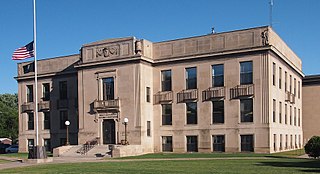
Marshall County is a county in the northwestern part of the U.S. state of Minnesota. As of the 2020 census, the population was 9,040. Its county seat is Warren.

<span class="mw-page-title-main">Mahnomen County, Minnesota</span> County in Minnesota, United States

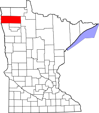
Mahnomen County is a county in the U.S. state of Minnesota. As of the 2020 census, the population was 5,411. Its county seat is Mahnomen.

<span class="mw-page-title-main">Lincoln County, Minnesota</span> County in Minnesota, United States

Lincoln County is a county in the U.S. state of Minnesota. As of the 2020 census, the population was 5,640. Its county seat is Ivanhoe.

<span class="mw-page-title-main">Le Sueur County, Minnesota</span> County in Minnesota, United States

Le Sueur County is a county located in the south central portion of the U.S. state of Minnesota. As of the 2020 census, the population was 28,674. Its county seat is Le Center.

<span class="mw-page-title-main">Kittson County, Minnesota</span> County in Minnesota, United States

Kittson County is a county in the northwestern corner of the U.S. state of Minnesota along the Canada–US border, south of the Canadian province of Manitoba. As of the 2020 census, the population was 4,207. Its county seat is Hallock.

<span class="mw-page-title-main">Kandiyohi County, Minnesota</span> County in Minnesota, United States

Kandiyohi County is a county in the U.S. state of Minnesota. As of the 2020 census, its population is 43,732. As of November 20, 1871, its county seat is Willmar.

<span class="mw-page-title-main">Jackson County, Minnesota</span> County in Minnesota, United States

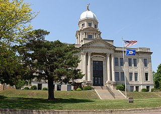
Jackson County is a county in the U.S. state of Minnesota. As of the 2020 census, the population was 9,989. Its county seat is Jackson.

<span class="mw-page-title-main">Big Stone County, Minnesota</span> County in Minnesota, United States

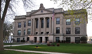
Big Stone County is a county in the U.S. state of Minnesota. As of the 2020 census, the population was 5,166. Its county seat is Ortonville.

<span class="mw-page-title-main">Halstad, Minnesota</span> City in Minnesota, United States

Halstad is a city in Norman County, Minnesota, United States. The population was 564 at the time of the 2020 census. The city is known for its production of sugar beets, and has a statue of a sugar beet, known as the world's largest sugar beet, to commemorate this status.

References

  1. "Minnesota Place Names". Minnesota Historical Society. Archived from the original on June 20, 2012. Retrieved March 18, 2014.
  2. 1 2 "State & County QuickFacts". United States Census Bureau. Retrieved April 10, 2023.
  3. "Find a County". National Association of Counties. Retrieved June 7, 2011.
  4. 1 2 Upham, Warren (1920). Minnesota Geographic Names: Their Origin and Historic Significance. Minnesota Historical Society. pp.  381–384.
  5. Gannett, Henry (1905). The Origin of Certain Place Names in the United States. Government Printing Office. p.  177. Norman County named after Norman Kittson.
  6. 1 2 3 4 5 6 Norman County MN Google Maps (accessed April 17, 2019)
  7. ""Find an Altitude/Norman County MN" Google Maps (accessed April 17, 2019)". Archived from the original on May 21, 2019. Retrieved April 17, 2019.
  8. "2010 Census Gazetteer Files". United States Census Bureau. August 22, 2012. Archived from the original on September 21, 2013. Retrieved October 24, 2014.
  9. Nelson, Steven (2011). Savanna Soils of Minnesota. Minnesota: Self. pp. 57-60. ISBN   978-0-615-50320-2.
  10. "Annual Estimates of the Resident Population for Counties: April 1, 2020 to July 1, 2023" . Retrieved March 18, 2024.
  11. "U.S. Decennial Census". United States Census Bureau. Retrieved October 24, 2014.
  12. "Historical Census Browser". University of Virginia Library. Retrieved October 24, 2014.
  13. "Population of Counties by Decennial Census: 1900 to 1990". United States Census Bureau. Retrieved October 24, 2014.
  14. "Census 2000 PHC-T-4. Ranking Tables for Counties: 1990 and 2000" (PDF). United States Census Bureau. Archived (PDF) from the original on March 27, 2010. Retrieved October 24, 2014.
  15. "P2 HISPANIC OR LATINO, AND NOT HISPANIC OR LATINO BY RACE – 2020: DEC Redistricting Data (PL 94-171) – Norman County, Minnesota".
  16. Leip, David. "Atlas of US Presidential Elections". uselectionatlas.org. Retrieved October 10, 2018.
  17. "Norman County". www.co.norman.mn.us. Retrieved April 25, 2023.
  18. "U.S. Senator Amy Klobuchar". www.klobuchar.senate.gov. Retrieved June 24, 2020.
  19. "Home". Senator Tina Smith. Retrieved June 24, 2020.

47°20′N96°28′W / 47.33°N 96.46°W / 47.33; -96.46