Cottonwood County, Minnesota

Last updated

Cottonwood County
Cottonwood County Courthouse.jpg
Cottonwood County Courthouse
Map of Minnesota highlighting Cottonwood County.svg
Location within the U.S. state of Minnesota
Minnesota in United States.svg
Minnesota's location within the U.S.
Coordinates: 44°01′N95°11′W / 44.01°N 95.18°W / 44.01; -95.18
CountryFlag of the United States.svg United States
StateFlag of Minnesota.svg  Minnesota
FoundedMay 23, 1857 (created)
July 29, 1870 (organized)
Named for Cottonwood River
Seat Windom
Largest cityWindom
Area
  Total649 sq mi (1,680 km2)
  Land639 sq mi (1,660 km2)
  Water10 sq mi (30 km2)  1.5%
Population
 (2020)
  Total11,517
  Estimate 
(2023)
11,319 Decrease2.svg
  Density18.0/sq mi (6.9/km2)
Time zone UTC−6 (Central)
  Summer (DST) UTC−5 (CDT)
Congressional districts 1st, 7th
Website www.co.cottonwood.mn.us

Cottonwood County is a county in the U.S. state of Minnesota. As of the 2020 census, the population was 11,517. [1] Its county seat is Windom. [2]

Contents

History

The county was created on May 23, 1857, named for the river in Germantown Township ("cottonwood" is the English meaning of the Dakota Sioux word "Waraju"). [3] [4] Minnesota Governor Horace Austin appointed three county commissioners when the county was established. They met at a home about six miles northwest of Windom on the Des Moines River at Big Bend. During this meeting, they designated the commissioners' districts and changed various county officers. The county organization was completed on July 29, 1870. The first general election was held in the county that November. The first deed of record was filed on January 10, 1870. The first land assessments were made in 1871, and the first taxes were paid in 1872. [5]

County NRHP listings

Soils of Cottonwood County Cottonwood Co Pie Chart No Text Version.pdf
Soils of Cottonwood County

Geography

The Heron Lake Outflow flows east through the lower part of Cottonwood County. The county terrain consists of low rolling hills, devoted to agriculture. [10] The terrain generally slopes to the east, with the northern portion also sloping north and the lower portion sloping south. The highest point is on the midpoint of the west border, at 1,535 ft (468 m) ASL. [11] The county has an area of 649 square miles (1,680 km2), of which 639 square miles (1,660 km2) is land and 10 square miles (26 km2) (1.5%) is water. [12]

Watersheds

The northeastern part of the county drains north to the Minnesota River through numerous small creeks, the Cottonwood River and Watonwan River. The southwestern part drains south through the Des Moines River. These two watersheds come together at the Mississippi River near Keokuk, Iowa. Most wetlands in the county have been drained for agricultural use.

Lakes

Source: [13]

Des Moines River WatershedMinnesota River Watershed

Major highways

Adjacent counties

Protected areas

Source: [14]

  • Arnolds Lake WMA
  • Banks WMA
  • Bennett WMA
  • Blixseth WPA
  • Budolfson WMA
  • Carpenter WMA
  • Clear Lake WPA
  • Cottonwood Lake WPA
  • Delft State Wildlife Management Area
  • Des Moines River WPA
  • Dynamite Park
  • Expandere WMA
  • Farhagen WMA
  • Harder Lake WPA
  • Hurricane Lake WMA
  • Lady Bird County Park
  • Lake Augusta WPA
  • Little Swan Lake State Wildlife Management Area
  • Long Lake WPA
  • Mound Creek County Park
  • Mountain County Park
  • Mountain Lake WMA
  • Mountain Lake WPA
  • Pats Grove County Park
  • Pats Pasture WMA
  • Pennington Prairie SNA
  • Regehr State Wildlife Management Area
  • Red Rock Falls County Park
  • Rock Ridge Prairie Scientific and Natural Area
  • Rock Ridge WMA
  • South Dutch Charlie County Park [15]
  • String Lakes WMA
  • Storden WPA
  • Talcot County Park
  • Talcot Lake WMA
  • Typhoon WMA
  • Voit WMA
  • Watonwan WPA
  • Wolf Lake WPA

[10]

Demographics

Historical population
CensusPop.Note
1860 12
1870 5344,350.0%
1880 5,533936.1%
1890 7,41234.0%
1900 12,06962.8%
1910 12,6514.8%
1920 14,57015.2%
1930 14,7821.5%
1940 16,1439.2%
1950 15,763−2.4%
1960 16,1662.6%
1970 14,887−7.9%
1980 14,854−0.2%
1990 12,694−14.5%
2000 12,167−4.2%
2010 11,687−3.9%
2020 11,517−1.5%
2023 (est.)11,319 [16] −1.7%
U.S. Decennial Census [17]
1790-1960 [18] 1900-1990 [19]
1990-2000 [20] 2010-2020 [1]

2020 Census

Cottonwood County Racial Composition [21]
RaceNum.Perc.
White (NH)9,41882%
Black or African American (NH)1351.2%
Native American (NH)250.22%
Asian (NH)3613.13%
Pacific Islander (NH)800.7%
Other/Mixed (NH)3833.33%
Hispanic or Latino 1,1159.7%

2000 census

2022 US Census population pyramid for Cottonwood County, from ACS 5-year estimates CottonwoodCountyMn2022PopPyr.png
2022 US Census population pyramid for Cottonwood County, from ACS 5-year estimates

As of the census of 2000, there were 12,167 people, 4,917 households, and 3,338 families in the county. The population density was 19.0 per square mile (7.3/km2). There were 5,376 housing units at an average density of 8.41 per square mile (3.25/km2). The racial makeup of the county was 95.23% White, 0.34% Black or African American, 0.23% Native American, 1.63% Asian, 0.08% Pacific Islander, 1.35% from other races, and 1.14% from two or more races. 2.19% of the population were Hispanic or Latino of any race. 50.2% were of German and 18.6% Norwegian ancestry.

There were 4,917 households, out of which 28.60% had children under the age of 18 living with them, 58.10% were married couples living together, 6.90% had a female householder with no husband present, and 32.10% were non-families. 28.90% of all households were made up of individuals, and 15.90% had someone living alone who was 65 years of age or older. The average household size was 2.39 and the average family size was 2.94.

The county population contained 25.00% under the age of 18, 6.50% from 18 to 24, 23.20% from 25 to 44, 23.20% from 45 to 64, and 22.10% who were 65 years of age or older. The median age was 42 years. For every 100 females there were 94.50 males. For every 100 females age 18 and over, there were 91.50 males.

The median income for a household in the county was $31,943, and the median income for a family was $40,237. Males had a median income of $28,993 versus $19,934 for females. The per capita income for the county was $16,647. About 7.40% of families and 11.70% of the population were below the poverty line, including 18.40% of those under age 18 and 8.70% of those age 65 or over.

Government and politics

Cottonwood County reliably votes Republican. In only one presidential election since 1964 has it selected the Democratic candidate.

United States presidential election results for Cottonwood County, Minnesota [22]
Year Republican Democratic Third party
No.%No.%No.%
2020 4,16568.20%1,83430.03%1081.77%
2016 3,67964.31%1,67829.33%3646.36%
2012 3,31656.57%2,43341.50%1131.93%
2008 3,15752.30%2,75945.71%1201.99%
2004 3,55755.85%2,72642.80%861.35%
2000 3,36954.51%2,50340.50%3095.00%
1996 2,63342.66%2,73744.35%80212.99%
1992 2,48137.30%2,38235.81%1,78826.88%
1988 3,39051.80%3,09547.29%600.92%
1984 4,27557.89%3,07341.61%370.50%
1980 4,25854.26%2,95837.70%6318.04%
1976 3,90649.70%3,81348.52%1401.78%
1972 4,39660.19%2,80238.37%1051.44%
1968 4,05054.80%3,04641.21%2953.99%
1964 3,42345.47%4,09054.33%150.20%
1960 5,08764.62%2,76835.16%170.22%
1956 4,61966.29%2,34433.64%50.07%
1952 5,48871.51%2,13027.76%560.73%
1948 3,22248.58%3,33350.26%771.16%
1944 3,91662.08%2,35437.32%380.60%
1940 4,22858.28%2,99141.23%360.50%
1936 2,50937.88%3,92959.32%1852.79%
1932 1,92139.40%2,87759.00%781.60%
1928 3,40567.45%1,60431.77%390.77%
1924 2,72256.99%2174.54%1,83738.46%
1920 3,88286.27%45110.02%1673.71%
1916 1,42560.23%76232.21%1797.57%
1912 32516.11%51125.33%1,18158.55%
1908 1,24065.82%52627.92%1186.26%
1904 1,53684.44%21311.71%703.85%
1900 1,36868.50%54727.39%824.11%
1896 1,24258.72%81038.30%632.98%
1892 72752.38%20214.55%45933.07%
County Board of Commissioners [23]
PositionNameDistrict
CommissionerLarry AndersonDistrict 1
Commissioner and ChairpersonKevin StevensDistrict 2
CommissionerDonna GravleyDistrict 3
CommissionerNorman HolvenDistrict 4
CommissionerTom AppelDistrict 5
State Legislature (2018-2020)
PositionNameAffiliationDistrict
Senate Bill Weber [24] Republican District 22
House of Representatives Rod Hamilton [25] Republican District 22B
U.S Congress (2021-2023)
PositionNameAffiliationDistrict
House of Representatives Brad Finstad [26] Republican 1st
House of Representatives Michelle Fischbach Republican 7th
Senate Amy Klobuchar [27] Democrat N/A
Senate Tina Smith [28] Democrat N/A

Communities

Cities

Unincorporated community

Townships

See also

Footnotes

  1. 1 2 "State & County QuickFacts". United States Census Bureau. Retrieved April 20, 2023.
  2. "Find a County". National Association of Counties. Archived from the original on May 31, 2011. Retrieved June 7, 2011.
  3. Upham, Warren (1920). Minnesota Geographic Names: Their Origin and Historic Significance. Minnesota Historical Society. p. 149.
  4. Gannett, Henry (1905). The Origin of Certain Place Names in the United States. Govt. Print. Off. p. 93.
  5. "About Cottonwood County". www.co.cottonwood.mn.us. Retrieved April 17, 2018.
  6. Nelson, Charles W.; Susan Zeik (October 26, 1976). "National Register of Historic Places Inventory Nomination Form: Cottonwood County Courthouse". National Park Service. Retrieved June 8, 2016.{{cite journal}}: Cite journal requires |journal= (help)
  7. 1 2 "National Register of Historic Places". NRHP. Retrieved October 15, 2015.
  8. "Cottonwood County Parks". Cottonwood County MN. Retrieved October 15, 2015.
  9. Nelson, Steven (2011). Savanna Soils of Minnesota. Minnesota: Self. pp. 69-70. ISBN   978-0-615-50320-2.
  10. 1 2 Cottonwood County MN Google Maps (accessed March 7, 2019)
  11. ""Find an Altitude/Cottonwood County MN" Google Maps (accessed March 7, 2019)". Archived from the original on May 21, 2019. Retrieved March 7, 2019.
  12. "2010 Census Gazetteer Files". United States Census Bureau. August 22, 2012. Archived from the original on October 6, 2014. Retrieved October 6, 2014.
  13. "Metadata: DNR Hydrography - All Water Features". resources.gisdata.mn.gov. Retrieved June 20, 2023.
  14. "Recreation Compass". Minnesota Department of Natural Resources. Retrieved June 20, 2023.
  15. The park is named after the county's first resident of European descent, Charles "Dutch Charlie" Zierke. "Cottonwood County Timeline". Cottonwood County Historical Society. Retrieved August 16, 2009.
  16. "Annual Estimates of the Resident Population for Counties: April 1, 2020 to July 1, 2023" . Retrieved March 18, 2024.
  17. "U.S. Decennial Census". United States Census Bureau. Retrieved October 6, 2014.
  18. "Historical Census Browser". University of Virginia Library. Archived from the original on August 11, 2012. Retrieved October 6, 2014.
  19. "Population of Counties by Decennial Census: 1900 to 1990". United States Census Bureau. Retrieved October 6, 2014.
  20. "Census 2000 PHC-T-4. Ranking Tables for Counties: 1990 and 2000" (PDF). United States Census Bureau. Archived (PDF) from the original on March 27, 2010. Retrieved October 6, 2014.
  21. "P2 HISPANIC OR LATINO, AND NOT HISPANIC OR LATINO BY RACE – 2020: DEC Redistricting Data (PL 94-171) – Cottonwood County, Minnesota".
  22. Leip, David. "Atlas of US Presidential Elections". uselectionatlas.org. Retrieved April 17, 2018.
  23. "Cottonwood County :: County Commissioners". www.co.cottonwood.mn.us. Retrieved June 25, 2020.
  24. "MN State Senate". www.senate.mn. Retrieved June 25, 2020.
  25. "Rep. Rod Hamilton (22B) - Minnesota House of Representatives". www.house.leg.state.mn.us. Retrieved June 25, 2020.
  26. "Republican Rep. Brad Finstad sworn in to finish Hagedorn's House term". August 12, 2022.
  27. "U.S. Senator Amy Klobuchar". www.klobuchar.senate.gov. Retrieved June 24, 2020.
  28. "Home". Senator Tina Smith. Retrieved June 24, 2020.

Further reading

44°01′N95°11′W / 44.01°N 95.18°W / 44.01; -95.18

Related Research Articles

<span class="mw-page-title-main">Watonwan County, Minnesota</span> County in Minnesota, United States

Watonwan County is a county in the U.S. state of Minnesota. As of the 2020 census, the population was 11,253. Its county seat is St. James.

<span class="mw-page-title-main">Wadena County, Minnesota</span> County in Minnesota, United States

Wadena County is a county in the U.S. state of Minnesota. As of the 2020 census, the population was 14,065. Its county seat is Wadena.

<span class="mw-page-title-main">Rice County, Minnesota</span> County in Minnesota, United States

Rice County is a county located in the south central portion of the U.S. state of Minnesota. As of the 2020 census, the population was 67,097. Its county seat is Faribault.

<span class="mw-page-title-main">Redwood County, Minnesota</span> County in Minnesota, United States

Redwood County is a county in the U.S. state of Minnesota. As of the 2020 census the population was 15,425. Its county seat is Redwood Falls, along the Redwood River near its confluence with the Minnesota River.

<span class="mw-page-title-main">Nobles County, Minnesota</span> County in Minnesota, United States

Nobles County is a county in the U.S. state of Minnesota. As of the 2020 census, the population was 22,290. Its county seat is Worthington. Nobles County comprises the Worthington, MN Micropolitan Statistical Area.

<span class="mw-page-title-main">Murray County, Minnesota</span> County in Minnesota, United States

Murray County is a county in the U.S. state of Minnesota. The population was 8,179 at the 2020 census. Its county seat is Slayton.

<span class="mw-page-title-main">Mille Lacs County, Minnesota</span> County in Minnesota, United States

Mille Lacs County is a county in the East Central part of the U.S. state of Minnesota. As of the 2020 census, the population was 26,459. Its county seat is Milaca. The county was founded in 1857, and its boundary was expanded in 1860.

<span class="mw-page-title-main">Martin County, Minnesota</span> County in Minnesota, United States

Martin County is a county in Minnesota, United States. As of the 2020 census, the population was 20,025. Its county seat is Fairmont.

<span class="mw-page-title-main">Lyon County, Minnesota</span> County in Minnesota, United States

Lyon County is a county in the U.S. state of Minnesota. As of the 2020 census, the population was 25,269. Its county seat is Marshall.

<span class="mw-page-title-main">Jackson County, Minnesota</span> County in Minnesota, United States

Jackson County is a county in the U.S. state of Minnesota. As of the 2020 census, the population was 9,989. Its county seat is Jackson.

<span class="mw-page-title-main">Hubbard County, Minnesota</span> County in Minnesota, United States

Hubbard County is a county in the northwestern part of the U.S. state of Minnesota. As of the 2020 census, the population was 21,344. Its county seat is Park Rapids.

<span class="mw-page-title-main">Brown County, Minnesota</span> County in Minnesota, United States

Brown County is a county in the U.S. state of Minnesota. As of the 2020 census, the population was 25,912. Its county seat is New Ulm. The county was formed in 1855 and organized in 1856.

<span class="mw-page-title-main">Blue Earth County, Minnesota</span> County in Minnesota, United States

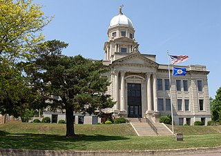
Blue Earth County is a county in the State of Minnesota. As of the 2020 census, the population was 69,112. Its county seat is Mankato. The county is named for the Blue Earth River and for the deposits of blue-green clay once evident along the banks of the Blue Earth River. Blue Earth County is part of the Mankato-North Mankato metropolitan area.

<span class="mw-page-title-main">Aitkin County, Minnesota</span> County in Minnesota, United States

Aitkin County is a county in the U.S. state of Minnesota. As of the 2020 census, the population was 15,697. Its county seat is Aitkin. Part of the Mille Lacs Indian Reservation is in the county. The county was created in 1857 and organized in 1871.

Bashaw Township is a township in Brown County, Minnesota, United States. The population was 243 as of the 2010 census.

Linden Township is a township in Brown County, Minnesota, United States. The population was 343 as of the 2000 census.

<span class="mw-page-title-main">Jeffers, Minnesota</span> City in Minnesota, United States

Jeffers is a city in Amboy Township, Cottonwood County, Minnesota, United States. The population was 369 at the 2010 census.

<span class="mw-page-title-main">Mountain Lake, Minnesota</span> City in Minnesota, United States

Mountain Lake is a city in Cottonwood County, Minnesota, United States. The population was 2,104 at the 2010 census.

<span class="mw-page-title-main">Mountain Lake Township, Cottonwood County, Minnesota</span> Township in Minnesota, United States

Mountain Lake Township is a township located in Cottonwood County, Minnesota, United States. According to the 2010 census, the population was 384. The township was organized in 1871.

<span class="mw-page-title-main">Windom, Minnesota</span> City in Minnesota, United States

Windom is a city and the county seat of Cottonwood County, Minnesota, United States. The population was 4,798 at the 2020 census. It is the county seat of Cottonwood County and is situated in the Coteau des Prairies.