Windom, Minnesota

Last updated

Windom
Downtown Windom MN.JPG
Shops in downtown Windom
Cottonwood County Minnesota Incorporated and Unincorporated areas Windom Highlighted.svg
Location of Windom
within Cottonwood County, Minnesota
Coordinates: 43°52′25″N95°07′13″W / 43.87361°N 95.12028°W / 43.87361; -95.12028
Country United States
State Minnesota
County Cottonwood
Platted1871
Incorporated1875
Government
  Type Mayorcouncil
  MayorDominic Jones (2017)[ citation needed ]
Area
[1]
  Total4.26 sq mi (11.03 km2)
  Land4.09 sq mi (10.61 km2)
  Water0.16 sq mi (0.42 km2)
Elevation
[2]
1,358 ft (414 m)
Population
 (2020)
  Total4,798
  Density1,171.67/sq mi (452.38/km2)
Time zone UTC-6 (Central (CST))
  Summer (DST) UTC-5 (CDT)
ZIP codes
56101, 56118
Area code 507
FIPS code 27-70798 [3]
GNIS feature ID2397339 [2]
Website www.windom-mn.com

Windom is a city and the county seat of Cottonwood County, Minnesota, United States. The population was 4,646 at the 2010 census. [4] It is the county seat of Cottonwood County [5] and is situated in the Coteau des Prairies.

Contents

Although a mostly small, rural farming community, Windom is host to several parks including a disc golf course at Mayflower Park. The Des Moines River flows through Windom and serves as a gentle, rapid-free canoeing spot.

History

Windom was platted on June 20, 1871, by A.L. Beach, an engineer for the Sioux City and St. Paul Railroad. [6] [7] Twelve lots were created and sold for $100 on the first day. [8] It was incorporated as a village in 1875 and reincorporated on September 9, 1884. [8] Judson W. Bishop named the city after William Windom, who served as a United States senator from Minnesota from 1881 to 1883 and was United States Secretary of the Treasury under Presidents James Garfield, Chester Arthur and Benjamin Harrison. [8] [9]

Geography

Windom lies 1,362 feet (415 m) above sea level. According to the United States Census Bureau, the city has a total area of 4.33 square miles (11.21 km2), of which 4.16 square miles (10.77 km2) is land and 0.17 square miles (0.44 km2) is water. [10] Windom is on the Coteau des Prairies, a ridge extending from South Dakota to Iowa separating Cottonwood County into two watersheds. [11] The watersheds drain into the Minnesota and Mississippi rivers. [11] The Des Moines River flows through Windom. [12]

Climate

The average winter temperature in Windom is 16 °F (−9 °C), in spring 44.7 °F (7.1 °C), in summer 69.8 °F (21.0 °C), and in fall 46.1 °F (7.8 °C). [13] The record high in Windom was set on August 1, 1988, at 105 °F (41 °C). [14] The record low was set on January 7, 1988, at −36 °F (−38 °C). [14] The maximum rainfall was 8.84 inches (225 mm), on September 23, 2010. [14]

Climate data for Windom, Minnesota
MonthJanFebMarAprMayJunJulAugSepOctNovDecYear
Record high °F (°C)65
(18)
66
(19)
84
(29)
93
(34)
98
(37)
103
(39)
103
(39)
105
(41)
100
(38)
91
(33)
80
(27)
64
(18)
105
(41)
Average high °F (°C)27
(−3)
32
(0)
44
(7)
60
(16)
72
(22)
82
(28)
85
(29)
82
(28)
75
(24)
61
(16)
43
(6)
29
(−2)
85
(29)
Average low °F (°C)7
(−14)
12
(−11)
24
(−4)
35
(2)
47
(8)
57
(14)
62
(17)
59
(15)
50
(10)
37
(3)
24
(−4)
11
(−12)
7
(−14)
Record low °F (°C)−36
(−38)
−31
(−35)
−25
(−32)
6
(−14)
20
(−7)
33
(1)
42
(6)
32
(0)
22
(−6)
9
(−13)
−17
(−27)
−28
(−33)
−36
(−38)
Average precipitation inches (mm).9
(23)
.75
(19)
1.97
(50)
3.24
(82)
3.55
(90)
4.56
(116)
4.05
(103)
3.52
(89)
3.29
(84)
2.18
(55)
1.67
(42)
.98
(25)
30.66
(778)
Source: Weather.com [15]

Demographics

2010 Age distribution census data 2010 age distribution graph-Windom.PNG
2010 Age distribution census data
Historical population
CensusPop.Note
1880 443
1890 83588.5%
1900 1,944132.8%
1910 1,749−10.0%
1920 2,12321.4%
1930 2,1230.0%
1940 2,80732.2%
1950 3,16512.8%
1960 3,69116.6%
1970 3,9527.1%
1980 4,66618.1%
1990 4,283−8.2%
2000 4,4904.8%
2010 4,6463.5%
2020 4,7983.3%
U.S. Decennial Census

2010 census

As of the census [16] of 2010, there were 4,646 people, 1,994 households, and 1,201 families residing in the city. The population density was 1,116.8 inhabitants per square mile (431.2/km2). There were 2,171 housing units at an average density of 521.9 per square mile (201.5/km2). The racial makeup of the city was 92.1% White, 1.4% African American, 0.3% Native American, 1.2% Asian, 0.3% Pacific Islander, 3.7% from other races, and 1.1% from two or more races. Hispanic or Latino of any race were 8.0% of the population.

There were 1,994 households, of which 26.9% had children under the age of 18 living with them, 47.4% were married couples living together, 9.4% had a female householder with no husband present, 3.5% had a male householder with no wife present, and 39.8% were non-families. 35.7% of all households were made up of individuals, and 16.3% had someone living alone who was 65 years of age or older. The average household size was 2.25 and the average family size was 2.91.

The median age in the city was 42.6 years. 23.2% of residents were under the age of 18; 6.8% were between the ages of 18 and 24; 23.1% were from 25 to 44; 25.8% were from 45 to 64; and 21.2% were 65 years of age or older. The gender makeup of the city was 48.2% male and 51.8% female.

2000 census

As of the census [3] of 2000, there were 4,490 people, 1,910 households, and 1,195 families residing in the city. The population density was 1,263.6 inhabitants per square mile (487.9/km2). There were 2,089 housing units at an average density of 587.9 per square mile (227.0/km2). The racial makeup of the city was 97.15% White, 0.24% African American, 0.33% Native American, 0.71% Asian, 0.11% Pacific Islander, 0.85% from other races, and 0.60% from two or more races. Hispanic or Latino of any race were 1.58% of the population.

There were 1,910 households, out of which 27.7% had children under the age of 18 living with them, 50.6% were married couples living together, 8.9% had a female householder with no husband present, and 37.4% were non-families. 34.0% of all households were made up of individuals, and 17.2% had someone living alone who was 65 years of age or older. The average household size was 2.25 and the average family size was 2.87.

In the city, the population was spread out, with 23.7% under the age of 18, 6.6% from 18 to 24, 24.4% from 25 to 44, 23.6% from 45 to 64, and 21.7% who were 65 years of age or older. The median age was 42 years. For every 100 females, there were 87.6 males. For every 100 females age 18 and over, there were 84.7 males.

The median income for a household in the city was $30,744, and the median income for a family was $43,350. Males had a median income of $30,053 versus $21,270 for females. The per capita income for the city was $17,155. About 5.7% of families and 9.6% of the population were below the poverty line, including 13.1% of those under age 18 and 11.0% of those age 65 or over.

Government

Windom is in Minnesota's 7th congressional district, represented by Michelle Fischbach, a Republican. At the state level, Windom is in Senate District 22, represented by Republican Bill Weber, and in House District 22B, represented by Republican Rod Hamilton. [17]

Windom operates under a Mayor-Council plan. [18] The council consists of 5 members representing two wards that are each separated into two precincts. [18] Four of the council members represent an individual precinct and serve four-year terms; the fifth is an at-large candidate and serves a two-year term. [18] Before a new city charter was introduced on June 20, 1984, [19] council members in Windom were called alderpersons. [20]

The mayor of Windom is Dominic Jones.

Infrastructure

Transportation

A view of Minnesota State Highway 60 as it passes through Windom. Windom, MN at night.jpg
A view of Minnesota State Highway 60 as it passes through Windom.

U.S. Highway 71, Minnesota Highway 60, and Minnesota Highway 62 are three of the main routes through the city.

Economy

On December 1, 1987, Windom adopted the Minnesota "Star City" program to promote economic development and pursue the "Star City" designation. [21] [22] The city received the designation in August 1988. [22]

Windom's largest employers are Toro, Windom Public Schools-ISD 177, and Fortune Transportation with 600, 176, and 175 employees respectively. [13] Windom is home to one of eight Toro manufacturing facilities. [23] It is also the headquarters of Big Game Treestands. [24]

Windom has a labor force of 2,378, of whom 2,295 are employed; 85 are unemployed, creating an unemployment rate of 3.5%. [25] The largest industries are educational services, health care and social assistance, with 26.3% of the employed population, and manufacturing, with 18.6% of the employed population. [25]

Media

The town is served by the Cottonwood County Citizen, a weekly newspaper. [26]

The town is also served by three radio stations licensed to the town, two commercial and one non-commercial.

CallsignFrequencyFormatOwnerReference
KDOM 1580 Full Service Windom Radio Incorporated [27]
KDOM-FM 94.3 Country Windom Radio Incorporated [28]
KJWR 90.9 Religious Minn-Iowa Christian Broadcasting Inc. [29]
KRLP-FM88.1ReligiousEducational Media Foundation

Education

Windom is home to several schools: Windom Area Middle/High School, Winfair Elementary School, Bridges Preschool and Red Rock Ridge ALC. It also has two private or church preschools: Busy Bees and Sunshine School.

Windom Area Middle/High School

Windom Area Middle/High School is home to students grade 4-12 due to renovations in 2003. [30] The building originally only housed grades 5-12 after the renovations, but had to accommodate 4th-grade students starting in 2011 due to overcrowding in the elementary school building. Roughly 300 students attend the high school (grades 9-12) and 350 attend the middle school (grades 4-8). [30] The school is led by Principal Bryan Joyce and Superintendent Jamie Frank. [31]

Entertainment

Riverfest

Windom holds an annual summer festival, Riverfest, during the second weekend of June. A pageant crowns a Miss Riverfest, a First Runner-Up, Miss Photogenic, Miss Congeniality and a Little Miss Riverfest. Other activities include fireworks, Vickie Schendel 5K Walk/Run, tennis tourney, fishing tourney, turtle races, kiddie tractor pull, street dance, and a grand parade.[ citation needed ]

Winter-River-Fest

In February 2011 Windom started a new festival, "Winter-River-Fest." Activities included a chili feed, open fires, dodgeball, snow sculpting, and the Darn Cold Croquet Contest. [32]

Notable people

Related Research Articles

<span class="mw-page-title-main">Cottonwood County, Minnesota</span> County in Minnesota, United States

Cottonwood County is a county in the U.S. state of Minnesota. As of the 2020 census, the population was 11,517. Its county seat is Windom.

<span class="mw-page-title-main">Cottonwood Falls, Kansas</span> City in Chase County, Kansas

Cottonwood Falls is the largest city and county seat of Chase County, Kansas, United States. As of the 2020 census, the population of the city was 851. It is located south of Strong City along the south side of the Cottonwood River.

<span class="mw-page-title-main">Windom, Kansas</span> City in McPherson County, Kansas

Windom is a city in McPherson County, Kansas, United States. As of the 2020 census, the population of the city was 85.

<span class="mw-page-title-main">Bingham Lake, Minnesota</span> City in Minnesota, United States

Bingham Lake is a city in Cottonwood County, Minnesota, United States. The population was 126 at the 2010 census.

Carson Township is a township in Cottonwood County, Minnesota, United States. The population was 280 at the 2010 census.

Dale Township is a township in Cottonwood County, Minnesota, United States. The population was 151 at the 2010 census.

Germantown Township is in Cottonwood County, Minnesota, United States. The population was 207 at the 2010 census.

<span class="mw-page-title-main">Jeffers, Minnesota</span> City in Minnesota, United States

Jeffers is a city in Amboy Township, Cottonwood County, Minnesota, United States. The population was 369 at the 2010 census.

Midway Township is a township in Cottonwood County, Minnesota, United States. The population was 219 at the 2010 census. The city of Mountain Lake is located in the township.

<span class="mw-page-title-main">Mountain Lake, Minnesota</span> City in Minnesota, United States

Mountain Lake is a city in Cottonwood County, Minnesota, United States. The population was 2,104 at the 2010 census.

<span class="mw-page-title-main">Storden, Minnesota</span> City in Minnesota, United States

Storden is a city in Cottonwood County, Minnesota, United States. The population was 219 at the 2010 census.

<span class="mw-page-title-main">Westbrook, Minnesota</span> City in Minnesota, United States

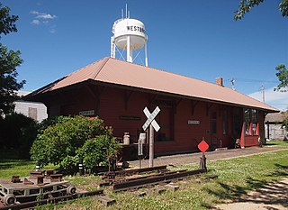
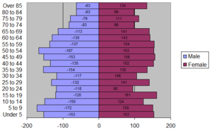
Westbrook is a city in Cottonwood County, Minnesota, United States. The population was 739 at the 2010 census.

<span class="mw-page-title-main">Caledonia, Minnesota</span> City in Minnesota, United States

Caledonia is a city and the county seat of Houston County, Minnesota, United States and is part of the La Crosse, Wisconsin Metropolitan Statistical Area. The population was 2,847 at the 2020 census.

<span class="mw-page-title-main">Cleveland, Minnesota</span> City in Minnesota, United States

Cleveland is a city in Le Sueur County, Minnesota, United States. The population was 719 at the 2010 census and 747 at the 2020 census.

<span class="mw-page-title-main">Cottonwood, Minnesota</span> City in Minnesota, United States

Cottonwood is a city in Lyon County, Minnesota, United States. The population was 1,212 at the 2010 census.

Lucas Township is a township in Lyon County, Minnesota, United States. The population was 260 at the 2000 census.

<span class="mw-page-title-main">Rose Creek, Minnesota</span> City in Minnesota, United States

Rose Creek is a city in Windom Township, Mower County, Minnesota, United States. The population was 394 at the 2010 census.

<span class="mw-page-title-main">Sanborn, Minnesota</span> City in Minnesota, United States

Sanborn is a city in Redwood County, Minnesota, United States. The population was 339 at the 2010 census.

<span class="mw-page-title-main">Ortonville, Minnesota</span> City in Minnesota, United States

Ortonville is a city in Big Stone County in the U.S. state of Minnesota at the southern tip of Big Stone Lake, along the border with South Dakota. The population was 2,021 at the 2020 census. It is the county seat of Big Stone County. Big Stone Lake State Park is nearby.

<span class="mw-page-title-main">Comfrey, Minnesota</span> City in Minnesota, United States

Comfrey is a city in Brown and Cottonwood counties in the U.S. state of Minnesota. The population was 382 at the 2010 census. The majority of the people live in Brown County.

References

  1. "2020 U.S. Gazetteer Files". United States Census Bureau. Retrieved July 24, 2022.
  2. 1 2 U.S. Geological Survey Geographic Names Information System: Windom, Minnesota
  3. 1 2 "U.S. Census website". United States Census Bureau . Retrieved January 31, 2008.
  4. "2010 Census Redistricting Data (Public Law 94-171) Summary File". American FactFinder. United States Census Bureau . Retrieved April 27, 2011.[ dead link ]
  5. "Find a County". National Association of Counties. Retrieved June 7, 2011.
  6. "About Windom: Overview & History". City of Windom. Retrieved June 4, 2012.
  7. "Hospital History". Windom Area Hospital. Retrieved June 4, 2010.
  8. 1 2 3 "Windom Minnesota Community Guide". LakesnWoods. Retrieved July 11, 2012.
  9. "Profile for Windom, Minnesota". ePodunk . Retrieved May 29, 2010.
  10. "US Gazetteer files 2010". United States Census Bureau. Archived from the original on January 25, 2012. Retrieved November 13, 2012.
  11. 1 2 "Comprehensive Local Water Management Plan 2007-2017" (PDF). Cottonwood County, Minnesota. Retrieved July 12, 2012.
  12. "Des Moines River". City of Windom. Retrieved July 12, 2012.
  13. 1 2 "City of Windom" (PDF). Community Profile. Economic Development Authority of Windom. Retrieved June 6, 2012.
  14. 1 2 3 "Record Extremes for Windom, MN". wunderground. Weather Underground. Retrieved July 15, 2012.
  15. "Monthly Averages for Windom, Minnesota". The Weather Channel. Retrieved July 6, 2012.
  16. "U.S. Census website". United States Census Bureau . Retrieved November 13, 2012.
  17. "Who Represents Me?". Legislative Coordinating Commission - Geospatial Information. LCC-GIS Office. Retrieved February 2, 2016.
  18. 1 2 3 "Charter" (PDF). City of Windom Minnesota. 2003. Archived (PDF) from the original on July 14, 2014. Retrieved June 19, 2012.
  19. City of Windom Resolution #23-84
  20. City of Windom Resolution #15-83
  21. City of Windom Resolution #83-87
  22. 1 2 City of Windom Resolution #90-09
  23. "NORTH AMERICA". The Toro Company. Retrieved July 12, 2012.
  24. "Dealer Services". Big Game Treestands. Retrieved July 12, 2012.
  25. 1 2 "Selected Economic Characteristics 2006-2010 American Community Survey 5-Year Estimates". American FactFinder. U.S. Census Bureau. Archived from the original on February 12, 2020. Retrieved June 6, 2012.
  26. "Home Page". Citizen. Retrieved July 12, 2012.
  27. AM Query Results -- Audio Division (FCC) USA
  28. FM Query Results -- Audio Division (FCC) USA
  29. FM Query Results -- Audio Division (FCC) USA
  30. 1 2 Windom Area High School, Windom, Minnesota
  31. WAHS Staff Listing
  32. "Outlook bright for Saturday's Winter-River-Fest". Citizen. February 10, 2011. Retrieved July 12, 2012.