Le Center, Minnesota

Last updated

Le Center, Minnesota
2009-0805-MN-114-LeCenter.jpg
Downtown Le Center
Nickname: 
Tree City USA
Motto: 
"The Heart Of LeSueur County"
Le Sueur County Minnesota Incorporated and Unincorporated areas Le Center Highlighted.svg
Location of Le Center
within Le Sueur County and state of Minnesota
Coordinates: 44°23′12″N93°43′52″W / 44.38667°N 93.73111°W / 44.38667; -93.73111
Country United States
State Minnesota
County Le Sueur
Government
  TypeMayor – Council
  MayorJosh Fredrickson [ citation needed ]
Area
[1]
  Total1.68 sq mi (4.34 km2)
  Land1.68 sq mi (4.34 km2)
  Water0.00 sq mi (0.00 km2)
Elevation
[2]
1,050 ft (320 m)
Population
 (2020)
  Total2,517
  Density1,501.79/sq mi (579.70/km2)
Time zone UTC-6 (Central (CST))
  Summer (DST) UTC-5 (CDT)
ZIP code
56057
Area code 507
FIPS code 27-36134 [3]
GNIS feature ID2395652 [2]
Website cityoflecenter.com

Le Center is a city and the county seat of Le Sueur County, Minnesota, United States. The population was 2,517 at the 2020 census. [4] [5] The Le Sueur County Courthouse and Jail are listed on the National Register of Historic Places.

Contents

Geography

According to the United States Census Bureau, the city has a total area of 1.51 square miles (3.91 km2), all land. [6]

Le Center is located 26 miles (42 km) from Mankato and 62 miles (100 km) from Minneapolis.

Minnesota State Highways 99 and 112 are two of the main routes in the community.

Demographics

Historical population
CensusPop.Note
1880 73
1890 169131.5%
1900 478182.8%
1910 74155.0%
1920 86316.5%
1930 9489.8%
1940 1,23230.0%
1950 1,3146.7%
1960 1,59721.5%
1970 1,89018.3%
1980 1,9674.1%
1990 2,0062.0%
2000 2,24011.7%
2010 2,49911.6%
2020 2,5170.7%
U.S. Decennial Census [7] [ failed verification ]
2020 [4]

As of 2000 the median income for a household in the city was $38,690, and the median income for a family was $47,143. Males had a median income of $30,901 versus $22,381 for females. The per capita income for the city was $17,225. About 6.6% of families and 7.6% of the population were below the poverty line, including 4.3% of those under age 18 and 17.3% of those age 65 or over.

2010 census

As of the census [8] of 2010, there were 2,499 people, 915 households, and 629 families residing in the city. The population density was 1,655.0 inhabitants per square mile (639.0/km2). There were 971 housing units at an average density of 643.0 per square mile (248.3/km2). The racial makeup of the city was 89.2% White, 0.2% African American, 0.2% Native American, 1.4% Asian, 8.4% from other races, and 0.5% from two or more races. Hispanic or Latino of any race were 21.0% of the population.

There were 915 households, of which 37.9% had children under the age of 18 living with them, 52.5% were married couples living together, 9.4% had a female householder with no husband present, 6.9% had a male householder with no wife present, and 31.3% were non-families. 27.1% of all households were made up of individuals, and 11.4% had someone living alone who was 65 years of age or older. The average household size was 2.67 and the average family size was 3.25.

The median age in the city was 32.8 years. 28.5% of residents were under the age of 18; 8.4% were between the ages of 18 and 24; 28.2% were from 25 to 44; 22.2% were from 45 to 64; and 12.6% were 65 years of age or older. The gender makeup of the city was 50.9% male and 49.1% female.

2020 Census

As of the census of 2020, there were 2,517 people, 923 households, and 181 families living in the city. [4] The population density was 1,498.21 inhabitants per square mile (578.5/km2). There were 999 housing units at an average density of 594.6 per square mile (229.6/km2). The racial makeup of the city was 73.8% White, 1.07% African American, 0.67% Asian, and 10.64% from two or more races. Hispanic or Latino of any race were 27.78% of the population.[ citation needed ]

There were 923 households, of which 28.0% had children under the age of 18 living with them, 44.6% were married couples living together, 27.2% had a female householder with no husband present, 18.6% had a male householder with no wife present, and 37.6% were non-families. 31.6% of all households were made up of individuals, and 16.8% had someone living alone who was 65 years of age or older. The average household size was 2.63 and the average family size was 3.28.[ citation needed ]

The median age in the city was 34.0 years. 28.0% of residents were under the age of 18; 7.4% were between the ages of 18 and 24; 44.2% were from 15 to 44; and 14.3% were 65 years of age or older. The gender makeup of the city was 51.6% male and 46.7% female.[ citation needed ]

Climate

Le Center has a humid continental climate (Köppen Dfa). Summers are warm and humid, while winters are cold and snowy.

Climate data for Le Center, Minnesota
MonthJanFebMarAprMayJunJulAugSepOctNovDecYear
Record high °F (°C)60
(16)
64
(18)
84
(29)
94
(34)
99
(37)
104
(40)
105
(41)
102
(39)
98
(37)
92
(33)
81
(27)
69
(21)
105
(41)
Average high °F (°C)23
(−5)
29
(−2)
41
(5)
58
(14)
71
(22)
80
(27)
84
(29)
81
(27)
73
(23)
61
(16)
41
(5)
27
(−3)
56
(13)
Average low °F (°C)2
(−17)
8
(−13)
21
(−6)
33
(1)
47
(8)
57
(14)
61
(16)
59
(15)
48
(9)
36
(2)
23
(−5)
9
(−13)
34
(1)
Record low °F (°C)−38
(−39)
−34
(−37)
−29
(−34)
4
(−16)
21
(−6)
37
(3)
40
(4)
36
(2)
25
(−4)
9
(−13)
−15
(−26)
−32
(−36)
−38
(−39)
Average snowfall inches (cm)7.5
(19)
6.2
(16)
7.9
(20)
1.6
(4.1)
0.2
(0.51)
0
(0)
0
(0)
0
(0)
0
(0)
0.1
(0.25)
4.5
(11)
7.4
(19)
35.4
(89.86)
Source: The Weather Channel [9]

Related Research Articles

Jamestown Township is a township in Blue Earth County, Minnesota, United States. The population was 628 as of the 2000 census.

Le Ray Township is a township in Blue Earth County, Minnesota, United States. The population was 846 as of the 2000 census.

<span class="mw-page-title-main">St. Clair, Minnesota</span> City in Minnesota, United States

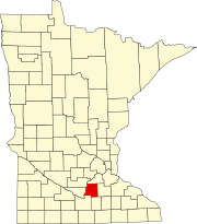
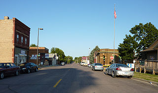
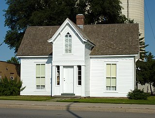
St. Clair or Saint Clair is a city in Blue Earth County, Minnesota, United States, located along the Le Sueur River. The population was 750 at the 2020 census. It is part of the Mankato-North Mankato Metropolitan Statistical Area.

<span class="mw-page-title-main">Cleveland, Minnesota</span> City in Minnesota, United States

Cleveland is a city in Le Sueur County, Minnesota, United States. The population was 719 at the 2010 census and 747 at the 2020 census.

Cordova Township is a township in Le Sueur County, Minnesota, United States. The population was 517 at the 2000 census.

Elysian Township is a township in Le Sueur County, Minnesota, United States. The population was 985 at the 2000 census.

<span class="mw-page-title-main">Heidelberg, Minnesota</span> City in Minnesota, United States

Heidelberg is a city in Le Sueur County, Minnesota, United States. The population was 122 at the 2010 census.

Kasota Township is a township in Le Sueur County, Minnesota, United States. The population was 1,487 at the 2000 census.

<span class="mw-page-title-main">Kilkenny, Minnesota</span> City in Minnesota, United States

Kilkenny is a city in Le Sueur County, Minnesota, United States. The population was 134 at the 2010 census.

Kilkenny Township is a township in Le Sueur County, Minnesota, United States. The population was 393 at the 2000 census.

Lanesburgh Township is a township in Le Sueur County, Minnesota, United States. The population was 2,074 at the 2000 census.

Lexington Township is a township in Le Sueur County, Minnesota, United States. The population was 763 at the 2000 census.

Montgomery Township is a township in Le Sueur County, Minnesota, United States. The population was 745 at the 2000 census.

Ottawa Township is a township in Le Sueur County, Minnesota, United States. The population was 290 at the 2000 census. Ottawa Township was organized in 1858.

<span class="mw-page-title-main">Waterville, Minnesota</span> City in Minnesota, United States

Waterville is a town in Le Sueur County, Minnesota, United States. The population was 1,868 at the 2010 census. It is close to Sakatah Lake State Park on the Cannon River.

Waterville Township is a township in Le Sueur County, Minnesota, United States. The population was 742 at the 2000 census.

<span class="mw-page-title-main">Le Roy, Minnesota</span> City in Minnesota, United States

Le Roy is a city in Mower County, Minnesota, United States, surrounded by Le Roy Township. The population was 929 at the 2010 census. Lake Louise State Park is just outside the town.

<span class="mw-page-title-main">Minnesota Lake, Minnesota</span> City in Minnesota, United States

Minnesota Lake is a city in Blue Earth and Faribault counties in the State of Minnesota. The population was 661 at the 2020 census. The bulk of the city is in Faribault County; a small part extends into Blue Earth County.

<span class="mw-page-title-main">Elysian, Minnesota</span> City in Minnesota, United States

Elysian is a city in Le Sueur and Waseca counties in the U.S. state of Minnesota. The population was 708 at the 2020 Census. The city is distinct from Elysian Township.

<span class="mw-page-title-main">Le Sueur, Minnesota</span> City in Minnesota, United States

Le Sueur is a city in Le Sueur County in the U.S. state of Minnesota, between Mankato and the Twin Cities. It lies along the Minnesota River and U.S. Highway 169. Le Sueur was named in honor of the French explorer Pierre-Charles Le Sueur. The population was 4,213 at the 2020 census.

References

  1. "2020 U.S. Gazetteer Files". United States Census Bureau. Retrieved July 24, 2022.
  2. 1 2 U.S. Geological Survey Geographic Names Information System: Le Center, Minnesota
  3. "U.S. Census website". United States Census Bureau . Retrieved January 31, 2008.
  4. 1 2 3 "Le Center city, Le Sueur County, Minnesota". census.gov. Retrieved January 20, 2022.
  5. "Find a County". National Association of Counties. Retrieved June 7, 2011.
  6. "US Gazetteer files 2010". United States Census Bureau. Archived from the original on July 2, 2012. Retrieved November 13, 2012.
  7. United States Census Bureau. "Census of Population and Housing" . Retrieved September 12, 2013.
  8. "U.S. Census website". United States Census Bureau . Retrieved November 13, 2012.
  9. "Seasonal Temperature and Precipitation Information". The Weather Channel. Retrieved July 28, 2008.