Kilkenny Township, Le Sueur County, Minnesota

Last updated

Kilkenny Township
USA Minnesota location map.svg
Red pog.svg
Kilkenny Township
Location within the state of Minnesota
Usa edcp location map.svg
Red pog.svg
Kilkenny Township
Kilkenny Township (the United States)
Coordinates: 44°19′15″N93°35′31″W / 44.32083°N 93.59194°W / 44.32083; -93.59194
Country United States
State Minnesota
County Le Sueur
Area
  Total36.1 sq mi (93.4 km2)
  Land33.8 sq mi (87.6 km2)
  Water2.2 sq mi (5.8 km2)
Elevation
1,070 ft (326 m)
Population
 (2000)
  Total393
  Density11.6/sq mi (4.5/km2)
Time zone UTC-6 (Central (CST))
  Summer (DST) UTC-5 (CDT)
FIPS code 27-33128 [1]
GNIS feature ID0664630 [2]

Kilkenny Township is a township in Le Sueur County, Minnesota, United States. The population was 393 at the 2000 census.

Contents

It was named after Kilkenny in Ireland. [3]

Geography

According to the United States Census Bureau, the township has a total area of 36.1 square miles (93 km2), of which 33.8 square miles (88 km2) is land and 2.2 square miles (5.7 km2) (6.21%) is water.

Demographics

As of the census [1] of 2000, there were 393 people, 157 households, and 113 families residing in the township. The population density was 11.6 people per square mile (4.5/km2). There were 173 housing units at an average density of 5.1/sq mi (2.0/km2). The racial makeup of the township was 97.78% White, and 2.21% from two or more races. Hispanic or Latino of any race were 1.02% of the population.

There were 157 households, out of which 26.8% had children under the age of 18 living with them, 63.7% were married couples living together, 5.7% had a female householder with no husband present, and 27.4% were non-families. 23.6% of all households were made up of individuals, and 10.2% had someone living alone who was 65 years of age or older. The average household size was 2.50 and the average family size was 2.99.

In the township the population was spread out, with 23.7% under the age of 18, 6.6% from 18 to 24, 26.0% from 25 to 44, 30.8% from 45 to 64, and 13.0% who were 65 years of age or older. The median age was 42 years. For every 100 females, there were 104.7 males. For every 100 females age 18 and over, there were 104.1 males.

The median income for a household in the township was $45,625, and the median income for a family was $149,063. Males had a median income of $145,139 versus $22,188 for females. The per capita income for the township was $21,346. About 9.5% of families and 10.0% of the population were below the poverty line, including 5.1% of those under age 18 and 15.8% of those age 65 or over.

Related Research Articles

Hiram Township is a township in Cass County, Minnesota, United States. The population was 334 as of the 2000 census. Hiram Township was named for Hiram Wilson, a pioneer settler.

Crow Wing Township is a township in Crow Wing County, Minnesota, United States. The population was 1,212 at the 2000 census.

Nokay Lake Township is a township in Crow Wing County, Minnesota, United States. The population was 681 at the 2000 census. This township took its name from Nokay Lake.

Bloomfield Township is a township in Fillmore County, Minnesota, United States. The population was 414 at the 2000 census. Bloomfield Township borders Beaver Township, Forestville Township, and Spring Valley Township.

Elbow Lake Township is a township in Grant County, Minnesota, United States. The population was 157 at the 2000 census.

Fahlun Township is a township in Kandiyohi County, Minnesota, United States. The population was 412 at the 2000 census.

Roseland Township is a township in Kandiyohi County, Minnesota, United States. The population was 477 at the 2000 census.

Westerheim Township is a township in Lyon County, Minnesota, United States. The population was 286 at the 2000 census.

Cedar Mills Township is a township in Meeker County, Minnesota, United States. The population was 499 at the 2000 census.

Dover Township is a township in Olmsted County, Minnesota, United States. The population was 440 at the 2000 census.

Dane Prairie Township is a township in Otter Tail County, Minnesota, United States. The population was 892 at the 2000 census.

Dead Lake Township is a township in Otter Tail County, Minnesota, United States. The population was 452 at the 2000 census.

<span class="mw-page-title-main">Deer Creek Township, Otter Tail County, Minnesota</span> Township in Minnesota, United States

Deer Creek Township is a township in Otter Tail County, Minnesota, United States. The population was 348 at the 2000 census.

Edna Township is a township in Otter Tail County, Minnesota, United States. The population was 921 at the 2000 census.

Sandstone Township is a township in Pine County, Minnesota, United States. The population was 1,614 at the 2000 census.

Holding Township is a township in Stearns County, Minnesota, United States. It includes the city of Holdingford. The township population was 1,139 at the 2010 census.

Scott Township is a township in Stevens County, Minnesota, United States. The population was 150 at the 2000 census.

Reynolds Township is a township in Todd County, Minnesota, United States. The population was 688 at the 2000 census and 735 in the 2020 census.

<span class="mw-page-title-main">Madelia Township, Watonwan County, Minnesota</span> Township in Minnesota, United States

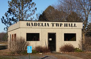
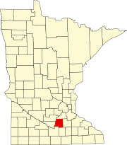
Madelia Township is a township in Watonwan County, Minnesota, United States. The population was 393 at the 2000 census.

Minnesota Falls Township is a township in Yellow Medicine County, Minnesota, United States. The population was 361 at the 2000 census.

References

  1. 1 2 "U.S. Census website". United States Census Bureau . Retrieved January 31, 2008.
  2. "US Board on Geographic Names". United States Geological Survey. October 25, 2007. Retrieved January 31, 2008.
  3. Upham, Warren (1920). Minnesota Geographic Names: Their Origin and Historic Significance. Minnesota Historical Society. p.  301.