Waterville Township, Le Sueur County, Minnesota

Last updated

Waterville Township
USA Minnesota location map.svg
Red pog.svg
Waterville Township
Location within the state of Minnesota
Usa edcp location map.svg
Red pog.svg
Waterville Township
Waterville Township (the United States)
Coordinates: 44°14′22″N93°34′45″W / 44.23944°N 93.57917°W / 44.23944; -93.57917
Country United States
State Minnesota
County Le Sueur
Area
  Total33.8 sq mi (87.5 km2)
  Land30.4 sq mi (78.7 km2)
  Water3.4 sq mi (8.8 km2)
Elevation
1,060 ft (323 m)
Population
 (2000)
  Total742
  Density24.4/sq mi (9.4/km2)
Time zone UTC-6 (Central (CST))
  Summer (DST) UTC-5 (CDT)
ZIP code
56096
Area code 507
FIPS code 27-68602 [1]
GNIS feature ID0665933 [2]

Waterville Township is a township in Le Sueur County, Minnesota, United States. The population was 742 at the 2000 census.

Contents

Waterville Township was organized in 1858, and named after Waterville. [3]

Geography

According to the United States Census Bureau, the township has a total area of 33.8 square miles (87.5 km2), of which 30.4 square miles (78.7 km2) is land and 3.4 square miles (8.8 km2) (10.07%) is water.

Demographics

As of the census [1] of 2000, there were 742 people, 265 households, and 214 families residing in the township. The population density was 24.4 people per square mile (9.4/km2). There were 396 housing units at an average density of 13.0/sq mi (5.0/km2). The racial makeup of the township was 98.38% White, 0.13% African American, 0.13% Native American, 0.27% Asian, 0.81% from other races, and 0.27% from two or more races. Hispanic or Latino of any race were 0.81% of the population.

There were 265 households, out of which 35.1% had children under the age of 18 living with them, 75.8% were married couples living together, 1.9% had a female householder with no husband present, and 19.2% were non-families. 15.5% of all households were made up of individuals, and 7.5% had someone living alone who was 65 years of age or older. The average household size was 2.79 and the average family size was 3.14.

In the township the population was spread out, with 27.2% under the age of 18, 6.3% from 18 to 24, 27.8% from 25 to 44, 25.6% from 45 to 64, and 13.1% who were 65 years of age or older. The median age was 37 years. For every 100 females, there were 110.8 males. For every 100 females age 18 and over, there were 109.3 males.

The median income for a household in the township was $53,929, and the median income for a family was $59,000. Males had a median income of $37,321 versus $22,321 for females. The per capita income for the township was $19,604. About 1.8% of families and 2.1% of the population were below the poverty line, including none of those under age 18 and 3.0% of those age 65 or over.

Related Research Articles

Prior Township is a township in Big Stone County, Minnesota, United States. The population was 223 as of the 2000 census.

May Township is a township in Cass County, Minnesota, United States. The population was 730 at the 2000 census. May Township was named for May Griffith, the daughter of a county official.

Verona Township is a township in Faribault County, Minnesota, United States. The population was 391 at the 2000 census.

Roscoe Township is a township in Goodhue County, Minnesota, United States. The population was 784 at the 2000 census.

Bigfork Township is a township in Itasca County, Minnesota, United States. The population was 321 at the 2010 census.

Bowstring Township is a township in Itasca County, Minnesota, United States. The population was 230 at the 2010 census.

Grattan Township is a township in Itasca County, Minnesota, United States. The population was 44 at the 2010 census.

Ann Lake Township is a township in Kanabec County, Minnesota, United States. The population was 377 at the 2000 census.

Arthur Township is a township in Kanabec County, Minnesota, United States. The population was 1,905 at the 2000 census.

<span class="mw-page-title-main">Waterville, Minnesota</span> City in Minnesota, United States

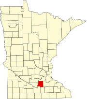
Waterville is a town in Le Sueur County, Minnesota, United States. The population was 1,868 at the 2010 census. It is close to Sakatah Lake State Park on the Cannon River.

Lafayette Township is a township in Nicollet County, Minnesota, United States. The population was 724 at the 2000 census.

Folden Township is a township in Otter Tail County, Minnesota. The population was 265 at the time of the 2000 census.

Hobart Township is a township in Otter Tail County, Minnesota, United States. The population was 733 at the 2000 census.

Newton Township is a township in Otter Tail County, Minnesota, United States. The population was 751 at the 2000 census.

Pine Lake Township is a township in Otter Tail County, Minnesota, United States. The population was 656 at the 2000 census.

Hubbard Township is a township in Polk County, Minnesota, United States. It is part of the Grand Forks-ND-MN Metropolitan Statistical Area. The population was 83 at the 2000 census.

<span class="mw-page-title-main">Morristown, Minnesota</span> City in Minnesota, United States

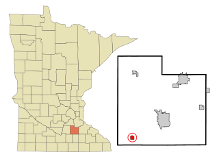
Morristown is a city in Rice County, Minnesota, United States. The population was 987 at the 2010 census.

Baker Township is a township in Stevens County, Minnesota, United States. The population was 265 at the 2000 census.

Watopa Township is a township in Wabasha County, Minnesota, United States. The population was 265 at the 2000 census.

<span class="mw-page-title-main">Osborn, Missouri</span> City in Missouri, United States

Osborn is a city in northern Clinton and southern DeKalb counties in the U.S. state of Missouri. The population was 374 at the 2020 census.

References

  1. 1 2 "U.S. Census website". United States Census Bureau . Retrieved January 31, 2008.
  2. "US Board on Geographic Names". United States Geological Survey. October 25, 2007. Retrieved January 31, 2008.
  3. Upham, Warren (1920). Minnesota Geographic Names: Their Origin and Historic Significance. Minnesota Historical Society. p.  303.