Lanesburgh Township, Le Sueur County, Minnesota

Last updated

Lanesburgh Township
USA Minnesota location map.svg
Red pog.svg
Lanesburgh Township
Location within the state of Minnesota
Usa edcp location map.svg
Red pog.svg
Lanesburgh Township
Lanesburgh Township (the United States)
Coordinates: 44°29′52″N93°35′3″W / 44.49778°N 93.58417°W / 44.49778; -93.58417
Country United States
State Minnesota
County Le Sueur
Area
  Total34.4 sq mi (89.2 km2)
  Land32.9 sq mi (85.3 km2)
  Water1.5 sq mi (3.9 km2)
Elevation
1,050 ft (320 m)
Population
 (2000)
  Total2,074
  Density63.0/sq mi (24.3/km2)
Time zone UTC-6 (Central (CST))
  Summer (DST) UTC-5 (CDT)
FIPS code 27-35468 [1]
GNIS feature ID0664722 [2]

Lanesburgh Township is a township in Le Sueur County, Minnesota, United States. The population was 2,074 at the 2000 census.

Contents

Lanesburgh Township was named for Charles L. Lane, a pioneer settler. [3]

Geography

According to the United States Census Bureau, the township has a total area of 34.5 square miles (89 km2), of which 32.9 square miles (85 km2) is land and 1.5 square miles (3.9 km2) (4.41%) is water.

Demographics

As of the census [1] of 2000, there were 2,074 people, 628 households, and 545 families residing in the township. The population density was 63.0 inhabitants per square mile (24.3/km2). There were 637 housing units at an average density of 19.3/sq mi (7.5/km2). The racial makeup of the township was 98.99% White, 0.05% African American, 0.05% Native American, 0.14% Asian, 0.29% from other races, and 0.48% from two or more races. Hispanic or Latino of any race were 0.58% of the population.

There were 628 households, out of which 53.0% had children under the age of 18 living with them, 81.5% were married couples living together, 3.3% had a female householder with no husband present, and 13.2% were non-families. 9.7% of all households were made up of individuals, and 4.0% had someone living alone who was 65 years of age or older. The average household size was 3.28 and the average family size was 3.52.

In the township the population was spread out, with 35.2% under the age of 18, 5.7% from 18 to 24, 34.6% from 25 to 44, 17.9% from 45 to 64, and 6.5% who were 65 years of age or older. The median age was 33 years. For every 100 females, there were 100.2 males. For every 100 females age 18 and over, there were 103.2 males.

The median income for a household in the township was $62,986, and the median income for a family was $65,083. Males had a median income of $39,769 versus $26,555 for females. The per capita income for the township was $20,782. About 2.7% of families and 3.4% of the population were below the poverty line, including 2.0% of those under age 18 and 14.2% of those age 65 or over.

Related Research Articles

Kego Township is a township in Cass County, Minnesota, United States. The population was 465 as of the 2000 census. Kego is a name derived from the Ojibwe language, meaning "fish".

Verona Township is a township in Faribault County, Minnesota, United States. The population was 391 at the 2000 census.

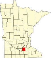
Albert Lea Township is a township in Freeborn County, Minnesota, United States. The population was 808 at the 2000 census.

Pine Island Township is a township located in Goodhue County, Minnesota, United States. As of the 2000 census, the township had a total population of 628.

Bowstring Township is a township in Itasca County, Minnesota, United States. The population was 230 at the 2010 census.

Grattan Township is a township in Itasca County, Minnesota, United States. The population was 44 at the 2010 census.

Third River Township is a township in Itasca County, Minnesota, United States. The population was 50 at the 2010 census.

Gudrid Township is a township in Lake of the Woods County, Minnesota, United States. The population was 235 at the 2000 census.

Milaca Township is a township in Mille Lacs County, Minnesota, United States. The population was 1,617 at the 2010 census.

Scandia Valley Township is a township in Morrison County, Minnesota, United States. The population was 1,074 at the 2000 census. According to the U. S. Census Bureau it was merged with Rail Prairie Township on 31 December 2002. The larger township reported a population of 1,191 inhabitants in the 2010 census.

Clitherall Township is a township in Otter Tail County, Minnesota, United States. The population was 549 at the 2000 census.

Effington Township is a township in Otter Tail County, Minnesota, United States. The population was 297 at the 2000 census.

Oscar Township is a township in Otter Tail County, Minnesota, United States. The population was 218 at the 2000 census.

Pine City Township is a township in Pine County, Minnesota, United States, located south and east of the city of Pine City. The township population was 1,249 at the 2000 census.

Fisher Township is a township in Polk County, Minnesota, United States. It is part of the Grand Forks-ND-MN Metropolitan Statistical Area. The population was 219 at the 2000 census.

Brookfield Township is a township in Renville County, Minnesota, United States. The population was 163 at the 2000 census.

Industrial Township is a township in Saint Louis County, Minnesota, United States. The population was 800 at the 2010 census.

Forest Lake Township was a township in Washington County, Minnesota, United States. The population was 7,642 at the 2000 census. It is now a part of the city of Forest Lake.

Wilkinson Township is a township in Cass County, Minnesota, United States. The population was 270 as of the 2000 census.

Wheatland Township is a township located in the northwest corner of Rice County, Minnesota, United States. The population was 1,358 at the 2000 census.

References

  1. 1 2 "U.S. Census website". United States Census Bureau . Retrieved January 31, 2008.
  2. "US Board on Geographic Names". United States Geological Survey. October 25, 2007. Retrieved January 31, 2008.
  3. Upham, Warren (1920). Minnesota Geographic Names: Their Origin and Historic Significance. Minnesota Historical Society. p.  302.