Granite Falls, Minnesota

Last updated

Granite Falls
Granite Falls Minnesota.jpg
Prentice Street in downtown Granite Falls in 2007
Yellow Medicine County Minnesota Incorporated and Unincorporated areas Granite Falls Highlighted.svg
Location of Granite Falls
within Yellow Medicine County, Minnesota
Coordinates: 44°48′38″N95°32′17″W / 44.81056°N 95.53806°W / 44.81056; -95.53806
CountryUnited States
State Minnesota
Counties Chippewa, Yellow Medicine
village1879
incorporatedApril 24, 1889
Government
   Mayor Dave Smiglewski
Area
[1]
  Total3.73 sq mi (9.66 km2)
  Land3.49 sq mi (9.05 km2)
  Water0.24 sq mi (0.61 km2)
Elevation
[2]
906 ft (276 m)
Population
 (2020) [3]
  Total2,737
  Estimate 
(2021) [4]
2,713
  Density783.34/sq mi (302.48/km2)
Time zone UTC-6 (CST)
  Summer (DST) UTC-5 (CDT)
ZIP code
56241
Area code 320
FIPS code 27-25280 [5]
GNIS feature ID2394962 [2]
Website granitefalls.com
The Yellow Medicine County Courthouse in 2007 Yellow Medicine County Courthouse.jpg
The Yellow Medicine County Courthouse in 2007

Granite Falls is a city located mostly in Yellow Medicine County, Minnesota, of which it is the county seat with a small portion in Chippewa County, Minnesota. The population was 2,737 at the 2020 census. [3] [6] The Andrew John Volstead House, a National Historic Landmark (NHL), is located in Granite Falls. Another NHL located in Granite Falls is the Julian A. Weaver House. [7]

Contents

History


In 1870 a post office began operating at Granite Falls. [8] The town was platted in 1872 [9] and named for deposits of granite rock in the area. [10] In 1874 the county seat was moved to Granite Falls and a small one courtroom courthouse was erected. In 1876 the Norwegian Evangelical Lutheran Congregation was formed and a church was built. Granite Falls was incorporated as a city in 1879 with East Granite Falls joining in 1889. [9] The existing county courthouse was erected in 1880. In 1888 the Chicago, Milwaukee and St. Paul Railroad built the town train station that still stands. The rail line remains active as a short line operated by the Twin Cities and Western Railroad (TC&W).

A grain elevator was built along the rail lines that today exists as the Farmers Co-Op elevator. In 2005 Granite Falls Energy LLC began producing Corn ethanol and extract Corn oil at their newly constructed plant.

2000 tornado

On July 25, 2000, the city of Granite Falls and Yellow Medicine County were hit by a powerful tornado. The tornado first touched down in rural parts of the county west-northwest of Granite Falls, hitting the city at 6:10 pm. After tearing through the residential sections of town, the tornado lifted at approximately 6:25PM after being on the ground for over nine miles. One person was killed, more than a dozen were injured, and the town and surrounding area suffered millions of dollars in property damage. Most of the damage in Granite Falls was rated F2 and F3, but the extent of the damage at the corner of 9th Avenue and 14th Street caused the National Weather Service to classify it as an F4 tornado. [11]

Geography

According to the United States Census Bureau, the city has a total area of 3.82 square miles (9.89 km2), of which 3.59 square miles (9.30 km2) is land and 0.23 square miles (0.60 km2) is water. [12]

U.S. Highway 212 and Minnesota State Highways 23 and 67 are three of the main routes in the city.

Climate

Granite Falls, along with the rest of Minnesota, has a humid continental climate [13] with significant differences between seasons. With a July mean temperature of 22.2 °C (72.0 °F) Granite Falls just falls into the hot-summer zone of the Köppen classification of the humid continental climate regime. [14] Winters are cold and dry influenced by arctic air masses affecting it through its continental position, while summers are influenced by humid subtropical air masses bringing hot temperatures and significant rainfall. Transitional periods are very short, since only April and October are between 0 °C (32 °F) and 10 °C (50 °F) in daily mean temperatures, with May–September being clearly above and November–March averaging below freezing. [14] The middle three months in each of those cycles are also clearly warmer and colder, respectively, than the months at the beginning or at the end of transitional periods. That is in turn a typical feature of continental climates.

Climate data for Granite Falls, Minnesota, 1991–2020 normals, extremes 1893present
MonthJanFebMarAprMayJunJulAugSepOctNovDecYear
Record high °F (°C)62
(17)
66
(19)
83
(28)
94
(34)
99
(37)
104
(40)
104
(40)
102
(39)
105
(41)
97
(36)
84
(29)
59
(15)
105
(41)
Mean maximum °F (°C)45.3
(7.4)
46.7
(8.2)
66.9
(19.4)
82.6
(28.1)
92.8
(33.8)
94.2
(34.6)
95.4
(35.2)
93.4
(34.1)
91.4
(33.0)
82.6
(28.1)
66.6
(19.2)
48.2
(9.0)
98.2
(36.8)
Mean daily maximum °F (°C)24.1
(−4.4)
29.0
(−1.7)
42.0
(5.6)
57.4
(14.1)
70.9
(21.6)
80.2
(26.8)
85.0
(29.4)
81.9
(27.7)
75.1
(23.9)
59.7
(15.4)
42.8
(6.0)
28.6
(−1.9)
56.4
(13.5)
Daily mean °F (°C)13.4
(−10.3)
17.8
(−7.9)
30.8
(−0.7)
45.2
(7.3)
58.0
(14.4)
67.8
(19.9)
72.4
(22.4)
69.7
(20.9)
61.6
(16.4)
47.5
(8.6)
32.5
(0.3)
19.2
(−7.1)
44.7
(7.0)
Mean daily minimum °F (°C)2.7
(−16.3)
6.6
(−14.1)
19.7
(−6.8)
32.9
(0.5)
45.1
(7.3)
55.3
(12.9)
59.8
(15.4)
57.5
(14.2)
48.0
(8.9)
35.4
(1.9)
22.3
(−5.4)
9.7
(−12.4)
32.9
(0.5)
Mean minimum °F (°C)−22.9
(−30.5)
−16.6
(−27.0)
−8.2
(−22.3)
16.2
(−8.8)
30.3
(−0.9)
43.6
(6.4)
49.0
(9.4)
45.6
(7.6)
33.5
(0.8)
19.3
(−7.1)
2.9
(−16.2)
−15.4
(−26.3)
−25.1
(−31.7)
Record low °F (°C)−36
(−38)
−33
(−36)
−22
(−30)
−1
(−18)
25
(−4)
34
(1)
36
(2)
34
(1)
20
(−7)
6
(−14)
−16
(−27)
−32
(−36)
−36
(−38)
Average precipitation inches (mm)0.81
(21)
0.83
(21)
1.47
(37)
2.41
(61)
3.50
(89)
4.56
(116)
3.27
(83)
3.81
(97)
3.18
(81)
2.35
(60)
1.37
(35)
1.08
(27)
28.64
(728)
Average snowfall inches (cm)9.4
(24)
11.7
(30)
7.9
(20)
3.9
(9.9)
0.1
(0.25)
0.0
(0.0)
0.0
(0.0)
0.0
(0.0)
0.0
(0.0)
0.8
(2.0)
6.6
(17)
11.1
(28)
51.5
(131.15)
Average precipitation days (≥ 0.01 in)5.95.35.97.39.410.47.97.77.37.34.65.584.5
Average snowy days (≥ 0.1 in)6.04.73.41.40.10.00.00.00.00.52.85.324.2
Source 1: NOAA [15]
Source 2: National Weather Service [16]

Demographics

Historical population
CensusPop.Note
1880 578
1890 80038.4%
1900 1,21451.8%
1910 1,45419.8%
1920 1,61110.8%
1930 1,79111.2%
1940 2,38833.3%
1950 2,5115.2%
1960 2,7288.6%
1970 3,22518.2%
1980 3,4517.0%
1990 3,083−10.7%
2000 3,070−0.4%
2010 2,897−5.6%
2020 2,737−5.5%
2021 (est.)2,713 [4] −0.9%
U.S. Decennial Census [17]
2020 Census [3]
Historical population
CensusPop.Note
1880 174
U.S. Census for East Granite Falls [18]

2010 census

As of the census of 2010, there were 2,897 people in 1,282 households, including 747 families, in the city. The population density was 807.0 inhabitants per square mile (311.6/km2). There were 1,417 housing units at an average density of 394.7 per square mile (152.4/km2). The racial makup of the city was 89.9% White, 0.6% African American, 5.2% Native American, 0.4% Asian, 1.8% from other races, and 2.1% from two or more races. Hispanic or Latino of any race were 4.7%. [19]

Of the 1,282 households 25.7% had children under the age of 18 living with them, 44.1% were married couples living together, 10.1% had a female householder with no husband present, 4.1% had a male householder with no wife present, and 41.7% were non-families. 37.2% of households were one person and 17.2% were one person aged 65 or older. The average household size was 2.17 and the average family size was 2.82.

The median age was 43 years. 21.5% of residents were under the age of 18; 8.8% were between the ages of 18 and 24; 22.3% were from 25 to 44; 26.9% were from 45 to 64; and 20.7% were 65 or older. The gender makeup of the city was 48.4% male and 51.6% female.

2000 census

As of the census of 2000, there were 3,070 people in 1,344 households, including 806 families, in the city. The population density was 890.5 inhabitants per square mile (343.8/km2). There were 1,472 housing units at an average density of 427.0 per square mile (164.9/km2). The racial makup of the city was 92.35% White, 0.07% African American, 5.70% Native American, 0.16% Asian, 0.42% from other races, and 1.30% from two or more races. Hispanic or Latino of any race were 2.15%.

Of the 1,344 households 27.7% had children under the age of 18 living with them, 50.5% were married couples living together, 7.7% had a female householder with no husband present, and 40.0% were non-families. 35.0% of households were one person and 18.5% were one person aged 65 or older. The average household size was 2.24 and the average family size was 2.91.

The age distribution was 24.1% under the age of 18, 7.9% from 18 to 24, 24.1% from 25 to 44, 22.0% from 45 to 64, and 21.8% 65 or older. The median age was 41 years. For every 100 females, there were 86.1 males. For every 100 females age 18 and over, there were 81.2 males.

The median household income was $32,031 and the median family income was $45,536. Males had a median income of $32,905 versus $22,957 for females. The per capita income for the city was $18,356. About 6.6% of families and 9.7% of the population were below the poverty line, including 6.8% of those under age 18 and 10.6% of those age 65 or over.

Politics

Presidential election results 1960–2020
Precinct General Election Results [20]
Year Republican Democratic Third parties
2020 52.8%52445.2% 4202.0% 30
2016 50.0%70641.7% 5898.3% 117
2012 40.6% 60557.4%8562.0% 30
2008 38.1% 59059.7%9262.2% 34
2004 38.4% 60660.4%9531.2% 20
2000 37.1% 55655.9%8387.0% 104
1996 25.5% 36062.3%88012.2% 173
1992 24.9% 39251.7%81523.4% 370
1988 45.9% 69354.1%8170.0% 0
1984 52.6%87047.4% 7830.0% 0
1980 48.9%87841.8% 7509.3% 166
1976 40.6% 73257.4%1,0362.0% 36
1972 54.6%93443.5% 7441.9% 33
1968 41.5% 64752.8%9235.7% 89
1964 42.7% 71357.2%9550.1% 3
1960 56.6%77643.0% 5900.4% 6

Media

Television

ChannelCallsignAffiliationBrandingSubchannelsOwner
(Virtual)ChannelProgramming
2.1K35DK-D
(KTCA Translator)
PBS TPT 22.2
2.4
Minnesota Channel
PBS Kids
Minnesota Valley TV Improvement Corporation
4.1K14OL-D CBS WCCO 44.2
4.4
14.1
14.2
14.3
14.4
14.5
18.1
Start TV
Youtoo America
MVTV
Retro TV
Rev'n
Family
Faith
Laff
Minnesota Valley TV Improvement Corporation
5.1K24CS-D
(KSTP Translator)
ABC 5 Eyewitness News5.7 Heroes & Icons Minnesota Valley TV Improvement Corporation
5.2K36OK-D
(KSTC Translator)
Ind.45 TV5.3
5.4
5.6
Me-TV
Antenna TV
This TV
Minnesota Valley TV Improvement Corporation
10.1K33OS-D
(KWCM Translator)
PBS Pioneer PBS10.2
10.3
10.4
10.5
Create
Minnesota Channel
World
PBS Kids
Minnesota Valley TV Improvement Corporation
11.1K16CP-D
(KARE Translator)
NBC KARE 1111.2
11.3
11.4
Court TV
True Crime Network
Quest
Minnesota Valley TV Improvement Corporation
22.1K22DO-D Action 22.2
22.3
22.4
22.5
Heartland
Biz TV
AMG TV
Grit
Minnesota Valley TV Improvement Corporation
23.1K19LX-D
(WUCW Translator)
CW CW 2323.2
23.3
23.4
Comet
Charge!
TBD
Minnesota Valley TV Improvement Corporation
41.1K32DR-D
(KPXM Translator)
ION ION41.2
41.3
41.4
41.5
41.6
Qubo
Ion Plus
ION Shop
QVC
HSN
Minnesota Valley TV Improvement Corporation

Infrastructure

Transportation

Related Research Articles

<span class="mw-page-title-main">Buhl, Idaho</span> City in Twin Falls, Idaho, United States

Buhl is a city located on the old Oregon Trail in the western half of Twin Falls County, Idaho. The population was 4,122 at the time of the 2010 census, up from 3,985 in 2000. It is part of the Twin Falls, Idaho metropolitan area.

<span class="mw-page-title-main">Iowa Falls, Iowa</span> City in Iowa, United States

Iowa Falls is a city in Hardin County, Iowa, United States. Iowa Falls is the home of Ellsworth Community College. It is also a regional transportation center, located along U.S. Routes 20 and 65 and the Canadian National and Union Pacific Railroads. The population was 5,106 at the time of the 2020 census.

<span class="mw-page-title-main">Beaconsfield, Iowa</span> City in Iowa, United States

Beaconsfield is a city in Ringgold County, Iowa, United States. The population was 15 in the 2020 census, unchanged from 2010 and an increase from 11 in 2000. In the 2000 census Beaconsfield was the least populated incorporated city in Iowa; with the increase in the 2020 census, it is now the second smallest, after Le Roy.

<span class="mw-page-title-main">Taylors Falls, Minnesota</span> City in Minnesota, United States

Taylors Falls is a city in Chisago County, Minnesota, United States, located at the junction of U.S. Highway 8 and Minnesota State Highway 95. The population was 1,055 at the 2020 census.

<span class="mw-page-title-main">Forada, Minnesota</span> City in Minnesota, United States

Forada is a city in Douglas County, Minnesota, United States. The population was 170 at the 2020 census.

<span class="mw-page-title-main">Clarks Grove, Minnesota</span> City in Minnesota, United States

Clarks Grove is a city in Freeborn County, Minnesota, United States. The population was 706 at the 2010 census.

<span class="mw-page-title-main">Hartland, Minnesota</span> City in Minnesota, United States

Hartland is a city in Freeborn County, Minnesota, United States. The population was 315 at the 2010 census.

<span class="mw-page-title-main">Big Falls, Minnesota</span> City in Minnesota, United States

Big Falls is a city in Koochiching County, Minnesota, United States. The population was 175 at the 2020 census.

<span class="mw-page-title-main">Baudette, Minnesota</span> City in Minnesota, United States

Baudette is a city in, and the county seat of, Lake of the Woods County, Minnesota, United States. As of the 2020 census, its population was 966. Baudette is known as the Walleye Capital of the World.

<span class="mw-page-title-main">Tyler, Minnesota</span> City in Minnesota, United States

Tyler is a city in Lincoln County, Minnesota, United States. The population of Tyler was 1,143 at the 2010 census.

<span class="mw-page-title-main">Slayton, Minnesota</span> City in Minnesota, United States

Slayton is a city in and the county seat of Murray County, Minnesota, United States. The population was 2,013 at the 2020 census.

<span class="mw-page-title-main">Dalton, Minnesota</span> City in Minnesota, United States

Dalton is a city in Otter Tail County, Minnesota, United States. The population was 215 at the 2020 census.

<span class="mw-page-title-main">Red Lake Falls, Minnesota</span> City in Minnesota, United States

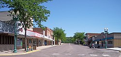
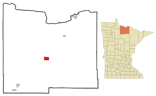
Red Lake Falls is a city and the county seat of Red Lake County, Minnesota, United States. The population was 1,339 at the 2020 census. It is the county seat of Red Lake County. The city lies in the middle of Red Lake Falls Township, from which it was separated when incorporated as a village in 1881. Its status was raised to that of a city in 1898.

<span class="mw-page-title-main">Zumbro Falls, Minnesota</span> City in Minnesota, United States

Zumbro Falls is a city along the Zumbro River in Wabasha County, Minnesota, United States. The population was 207 at the 2010 census. U.S. Highway 63 and Minnesota 60 intersect in Zumbro Falls.

<span class="mw-page-title-main">Aldrich, Minnesota</span> City in Minnesota, United States

Aldrich is a city in Wadena County, Minnesota, United States, along the Partridge River. The population was 48 at the 2010 census. The small community holds the distinction as the first permanent settlement in Wadena County and the first to establish a post office. It is also home to the first Catholic church in the area, established in 1870, as a mission church.

<span class="mw-page-title-main">Balfour, North Dakota</span> City in North Dakota, United States

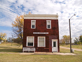
Balfour is a city in McHenry County, North Dakota, United States. The population was 20 at the 2020 census. It is part of the Minot Micropolitan Statistical Area.

<span class="mw-page-title-main">Selby, South Dakota</span> City in South Dakota, United States

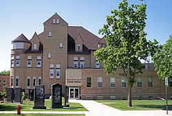
Selby is a city in Walworth County, South Dakota, United States. The population was 610 at the 2020 census. It is the county seat of Walworth County.

<span class="mw-page-title-main">Rothsay, Minnesota</span> City in Minnesota, United States

Rothsay is a city in Otter Tail and Wilkin counties in the State of Minnesota. The population was 498 at the 2020 census. One of Rothsay's major tourist attractions is the large prairie chicken statue near the northwest outskirts of the town.

<span class="mw-page-title-main">Jasper, Minnesota</span> City in Minnesota, United States

Jasper is a city in Pipestone and Rock counties in the State of Minnesota. The population was 633 at the 2010 census. Most of the city lies in Pipestone County, with only a small part of the city extending into Rock County.

<span class="mw-page-title-main">Redwood Falls, Minnesota</span> City in the United States

Redwood Falls is a city in Redwood County, located along the Redwood River near its confluence with the Minnesota River, in the U.S. state of Minnesota. The population was 5,102 at the 2020 census. It is the county seat.

References

  1. "2020 U.S. Gazetteer Files". United States Census Bureau. Retrieved July 24, 2022.
  2. 1 2 U.S. Geological Survey Geographic Names Information System: Granite Falls, Minnesota
  3. 1 2 3 "Explore Census Data". United States Census Bureau . Retrieved July 4, 2022.
  4. 1 2 "City and Town Population Totals: 2020-2021". United States Census Bureau. July 4, 2022. Retrieved July 4, 2022.
  5. "U.S. Census website". United States Census Bureau . Retrieved January 31, 2008.
  6. "Find a County". National Association of Counties. Archived from the original on May 31, 2011. Retrieved June 7, 2011.
  7. Granger, Susan (1985). "Julian A. Weaver House, Granite Falls MInnesota". NPGallery, National Park Service (npgallery.nps.gov). Minnesota Historical Society.
  8. "Yellow Medicine County". Jim Forte Postal History. Retrieved August 16, 2015.
  9. 1 2 Upham, Warren (1920). Minnesota Geographic Names: Their Origin and Historic Significance. Minnesota Historical Society. p.  594.
  10. Gannett, Henry (1905). The Origin of Certain Place Names in the United States. Govt. Print. Off. pp.  141.
  11. "Granite Falls Tornado: July 25, 2000 - Minnesota DNR". www.dnr.state.mn.us. Retrieved December 16, 2019.
  12. "US Gazetteer files 2010". United States Census Bureau. Archived from the original on January 25, 2012. Retrieved November 13, 2012.
  13. "Granite Falls, Minnesota Climate Summary". Weatherbase. Retrieved March 21, 2015.
  14. 1 2 "Granite Falls, Minnesota Temperature Averages". Weatherbase. Retrieved March 21, 2015.
  15. "U.S. Climate Normals Quick Access – Station: Granite Falls, MN". National Oceanic and Atmospheric Administration. Retrieved May 13, 2023.
  16. "NOAA Online Weather Data – NWS Minneapolis". National Weather Service. Retrieved May 13, 2023.
  17. United States Census Bureau. "Census of Population and Housing" . Retrieved October 28, 2014.
  18. "Census of Population and Housing". Census.gov. Retrieved June 29, 2019.
  19. "U.S. Census website". United States Census Bureau . Retrieved November 13, 2012.
  20. "Office of the Minnesota Secretary of State - Election Results". Archived from the original on February 22, 2021. Retrieved February 22, 2021.