Crookston, Minnesota

Last updated

Crookston, Minnesota
Crookston Commercial Historic District.jpg
Crookston Commercial Historic District
Crookstonseal.png
Polk County Minnesota Incorporated and Unincorporated areas Crookston Highlighted.svg
Location of Crookston
within Polk County and state of Minnesota
Coordinates: 47°46′27″N96°36′29″W / 47.77417°N 96.60806°W / 47.77417; -96.60806
CountryUnited States
State Minnesota
County Polk
Metro Greater Grand Forks
Settled1872
Organized1876
Incorporated February 14, 1879
Government
  TypeMayor-council (weak-mayor, strong-council)
   Mayor Dale Stainbrook [1]
   City Administrator Charles Reynolds
   City Council Kristie Jerde
Henry Fischer
Clayton Briggs
Don Cavalier
Joe Kresl
Dylane Klatt
Tim Menard
Morgan Hibma
Area
[2]
   City 5.115 sq mi (13.249 km2)
  Land5.115 sq mi (13.249 km2)
  Water0.000 sq mi (0.000 km2)
  Metro
3,407 sq mi (8,825 km2)
Elevation
[3]
876 ft (267 m)
Population
 (2020) [4]
   City 7,482
  Estimate 
(2022) [5]
7,323
  Density1,446/sq mi (558/km2)
   Metro
103,120
  Metro density30.3/sq mi (11.69/km2)
Time zone UTC–6 (Central (CST))
  Summer (DST) UTC–5 (CDT)
ZIP Code
56716
Area code 218
FIPS code 27-13870
GNIS feature ID0642475 [3]
Sales tax 7.375% [6]
Website crookston.mn.us
Aerial view of Crookston, Minnesota, with the Red Lake River twisting through the town Crookston Minnesota aerial view.jpg
Aerial view of Crookston, Minnesota, with the Red Lake River twisting through the town

Crookston is a city in the U.S. state of Minnesota. It is the county seat of Polk County. [7] The population was 7,482 at the 2020 census. [4] It is part of the "Grand Forks, ND-MN Metropolitan Statistical Area" or "Greater Grand Forks".

Contents

Crookston is the episcopal seat of the Roman Catholic Diocese of Crookston. Crookston is partially a commuter town to the larger city of Grand Forks, North Dakota.

History

Early history

The Crookston area was virtually unoccupied until European contact and remained little more than a hunting ground associated with the Pembina settlements until the 1860s. [8] The land in Crookston's immediate vicinity is not connected with any verifiable Native American or European historic events or circumstances until transfer in the Treaties of Old Crossing in 1863–64.[ citation needed ] Before that, the territory now included in Crookston was part of Rupert's Land and Assiniboia before becoming part of the United States as a result of the boundary settlement in the Treaty of 1818. [8]

The Crookston area was traversed by trappers and traders, including Ojibwa and Lakota Indians, Métis, and other mixed-race people as well as white men between 1790 and 1870. A branch of the Red River Trails passed nearby; it was used by fur traders between the 1840s and 1870s. [9]

Settlement

The present-day site of Crookston first saw settlement by non-Indian people around 1872. [10] It was the site of a federal land office [10] by 1876 and sited on a portion of the Great Northern Railway that began operation by 1880. The town was incorporated on April 1, 1879 [10] as "Queen City". By the end of that year, the town had a jail, graded streets, and a few plank sidewalks. Soon it was decided that the town needed a new name. Two factions emerged supporting two different names. One wished to honor the town's first mayor, Captain Ellerey C. Davis, with the name Davis. Another group picked the name Crookston to honor Colonel William Crooks, [10] a soldier and railroad builder. The name was reportedly chosen by coin toss.

Soon Scandinavian, French-Canadian, and German immigrants began populating Crookston. At one point, eight different railroad lines reached the town, and it became a center of commerce and manufacturing.

Geography

According to the United States Census Bureau, the city has a total area of 5.115 square miles (13.25 km2), all land. [2]

Crookston sits in the fertile Red River Valley, once a part of glacial Lake Agassiz. As Lake Agassiz receded, it left behind rich mineral deposits. This made the area around Crookston prime for agricultural uses. Grains such as wheat and other crops, including sugar beets and potatoes, grow well in the area around Crookston.

Crookston has a relatively flat landscape. The Red Lake River flows through the city and makes several twists and turns (oxbows). The riverbank has eroded somewhat.

U.S. Highways 2 and 75 and Minnesota State Highways 9 and 102 are four of the main routes in the community.

Crookston is the northern terminus of the Agassiz Recreational Trail, a 53-mile multi-use trail built on an abandoned railroad grade that has its southern terminus at Ulen. [11]

Climate

Climate data for Crookston, Minnesota, 1991–2020 normals, extremes 1890–present
MonthJanFebMarAprMayJunJulAugSepOctNovDecYear
Record high °F (°C)57
(14)
63
(17)
78
(26)
96
(36)
101
(38)
102
(39)
105
(41)
104
(40)
99
(37)
89
(32)
73
(23)
56
(13)
105
(41)
Mean maximum °F (°C)37.7
(3.2)
39.4
(4.1)
54.2
(12.3)
74.2
(23.4)
85.4
(29.7)
89.6
(32.0)
90.7
(32.6)
91.6
(33.1)
88.4
(31.3)
77.2
(25.1)
56.3
(13.5)
40.7
(4.8)
93.9
(34.4)
Mean daily maximum °F (°C)15.8
(−9.0)
20.4
(−6.4)
34.0
(1.1)
51.3
(10.7)
66.6
(19.2)
76.0
(24.4)
80.3
(26.8)
79.6
(26.4)
70.4
(21.3)
54.1
(12.3)
36.2
(2.3)
22.4
(−5.3)
50.6
(10.3)
Daily mean °F (°C)6.1
(−14.4)
10.1
(−12.2)
24.4
(−4.2)
40.7
(4.8)
54.7
(12.6)
65.1
(18.4)
69.1
(20.6)
67.4
(19.7)
58.2
(14.6)
43.7
(6.5)
27.5
(−2.5)
13.8
(−10.1)
40.1
(4.5)
Mean daily minimum °F (°C)−3.6
(−19.8)
−0.2
(−17.9)
14.8
(−9.6)
30.1
(−1.1)
42.8
(6.0)
54.3
(12.4)
57.8
(14.3)
55.2
(12.9)
46.0
(7.8)
33.3
(0.7)
18.8
(−7.3)
5.2
(−14.9)
29.5
(−1.4)
Mean minimum °F (°C)−27.9
(−33.3)
−23.0
(−30.6)
−10.8
(−23.8)
14.5
(−9.7)
27.8
(−2.3)
41.1
(5.1)
46.0
(7.8)
42.8
(6.0)
30.4
(−0.9)
18.3
(−7.6)
−1.6
(−18.7)
−17.2
(−27.3)
−28.4
(−33.6)
Record low °F (°C)−44
(−42)
−51
(−46)
−39
(−39)
−10
(−23)
6
(−14)
27
(−3)
38
(3)
31
(−1)
11
(−12)
−2
(−19)
−30
(−34)
−38
(−39)
−51
(−46)
Average precipitation inches (mm)0.51
(13)
0.53
(13)
0.73
(19)
1.27
(32)
2.75
(70)
4.15
(105)
3.27
(83)
2.97
(75)
2.60
(66)
2.09
(53)
0.82
(21)
0.74
(19)
22.43
(569)
Average snowfall inches (cm)9.1
(23)
8.4
(21)
6.1
(15)
3.0
(7.6)
0.1
(0.25)
0.0
(0.0)
0.0
(0.0)
0.0
(0.0)
0.0
(0.0)
1.0
(2.5)
5.8
(15)
11.5
(29)
45
(113.35)
Average precipitation days (≥ 0.01 in)6.45.85.96.210.010.79.38.28.17.35.77.390.9
Average snowy days (≥ 0.1 in)5.95.43.51.50.10.00.00.00.00.62.87.026.8
Source: NOAA [12] [13]

Demographics

Historical population
CensusPop.Note
1880 1,227
1890 3,457181.7%
1900 5,35955.0%
1910 7,55941.1%
1920 6,825−9.7%
1930 6,321−7.4%
1940 7,16113.3%
1950 7,3522.7%
1960 8,54616.2%
1970 8,312−2.7%
1980 8,6283.8%
1990 8,119−5.9%
2000 8,1920.9%
2010 7,891−3.7%
2020 7,482−5.2%
2022 (est.)7,323 [5] −2.1%
U.S. Decennial Census [14]
2020 Census [4]

Crookston has not seen major population growth since the 1970s. The economy has suffered due to a lack of well-paying jobs and available housing. [15]

2020 census

As of the 2020 census, there were 7,482 people and 3,087 households, and 1,647 families residing in the city. [16] The population density was 1,446.4 inhabitants per square mile (558.5/km2). [17] There were 3,445 housing units. The racial makeup was 80.9% White, 3.3% African American, 1.9% Native American, 0.8% Asian, 0.0% Native Hawaiian, 4.3% other races, and 8.8% from two or more races. Hispanic or Latino of any race were 14.5% of the population. [18]

2010 census

As of the 2010 census, there were 7,891 people, 3,109 households, and 1,743 families living in the city. The population density was 1,532.2 inhabitants per square mile (591.6/km2). There were 3,303 housing units at an average density of 641.4 per square mile (247.6/km2). The racial makeup of the city was 90.2% White, 1.4% African American, 1.7% Native American, 1.6% Asian, 2.8% from other races, and 2.3% from two or more races. Hispanic or Latino of any race were 11.0% of the population.

There were 3,109 households, of which 28.5% had children under the age of 18 living with them. 40.3% were married couples living together, 11.1% had a female householder with no husband present, 4.7% had a male householder with no wife present, and 43.9% were non-families. 36.7% of all households were made up of individuals, and 13.3% had someone living alone who was 65 years of age or older. The average household size was 2.27 and the average family size was 2.97.

The median age in the city was 35.1 years. 22.3% of residents were under the age of 18; 16.7% were between the ages of 18 and 24; 20.5% were from 25 to 44; 25% were from 45 to 64; and 15.5% were 65 years of age or older. The gender makeup of the city was 49.4% male and 50.6% female.

2000 census

As of the 2000 census, there were 8,192 people, 3,078 households, and 1,819 families living in the city. The population density was 1,658.8 inhabitants per square mile (640.5/km2). There were 3,382 housing units at an average density of 684.8 per square mile (264.4/km2). The racial makeup of the city was 90.5% White, 0.50% African American, 1.54% Native American, 0.49% Asian, 0.02% Pacific Islander, 4.64% from other races, and 1.56% from two or more races. Hispanic or Latino of any race were 8.18% of the population.

There were 3,078 households, of which 30.5% had children under the age of 18 living with them, 46.5% were married couples living together, 9.6% had a female householder with no husband present, and 40.9% were non-families. 34.5% of all households were made up of individuals, and 15.5% had someone living alone who was 65 years of age or older. The average household size was 2.37 and the average family size was 3.10.

The city's age distribution shows 24.2% under the age of 18, 14.9% from 18 to 24, 23.8% from 25 to 44, 19.5% from 45 to 64, and 17.6% who were 65 years of age or older. The median age was 36 years. For every 100 females, there were 93.4 males. For every 100 females age 18 and over, there were 91.5 males.

The median income for a household in the city was $34,609, and the median income for a family was $44,157. Males had a median income of $30,564 versus $21,021 for females. The per capita income for the city was $17,219. About 7.5% of families and 12.5% of the population were below the poverty line, including 14.4% of those under age 18 and 14.7% of those age 65 or over.

Education

K–12

Crookston is in Crookston School District 593, and is home to Crookston High School, home of the Pirates. Students from the neighboring towns of Euclid, Gentilly, and Mentor attend Crookston High. The school district enrolled 1,135 students in K-12 in the school year 2022–23. [19] Before the new high school was built in 1997, students attended Central High School in downtown Crookston. Central High School had been in operation since 1913.

Private elementary schools include Cathedral Elementary (Catholic, formerly Mount Saint Benedict High School), Our Savior's Lutheran, and Bible Baptist.

Higher education

Crookston has the University of Minnesota Crookston (a campus of the University of Minnesota system). It began as an agricultural high school before becoming a two-year college and then a four-year university. [20] On January 30, 2010, the new Crookston Sports Center was dedicated. The university enrolled about 1,650 students in the fall 2023 term. [21]

Media

The local newspaper is the Crookston Daily Times .

Television

Crookston is part of the Fargo/Grand Forks television market. PBS member station KCGE (channel 16) is licensed to Crookston, serving Grand Forks.

Local radio stations

KROX 1260 AM (also broadcast locally on translator K289CE 105.7 FM) specifically covers the community. Radio stations from Grand Forks, Thief River Falls, and KRJB 106.5 FM broadcasting from Ada can also be easily received. Radio stations KQHT 96.1 FM and KYCK 97.1 FM are also licensed to Crookston, but broadcast from Grand Forks and serve the region in general.

Culture

Crookston is home to the Grand Theater, the oldest continuously operating movie theater in the United States. Built in 1910, it served as an opera house until 1917, when it began to primarily show movies. It played host to entertainers including early film actress Mary Pickford. [22]

Notable people

Related Research Articles

<span class="mw-page-title-main">Polk County, Minnesota</span> County in Minnesota, United States

Polk County is a county in the northwestern part of the U.S. state of Minnesota. The population was 31,192 at the 2020 census. Its county seat is Crookston, and the largest community is East Grand Forks.

<span class="mw-page-title-main">Marshall County, Minnesota</span> County in Minnesota, United States

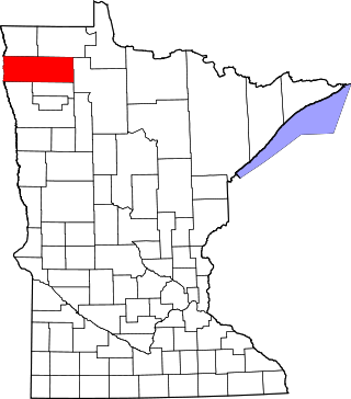
Marshall County is a county in the northwestern part of the U.S. state of Minnesota. As of the 2020 census, the population was 9,040. Its county seat is Warren.

<span class="mw-page-title-main">Blackduck, Minnesota</span> City in Minnesota, United States

Blackduck is a city in Beltrami County, Minnesota, United States. The population was 845 as of the 2020 census. It is 24 mi (39 km) northeast of Bemidji.

<span class="mw-page-title-main">Kenyon, Minnesota</span> City in Minnesota, United States

Kenyon is a city in southwestern Goodhue County, Minnesota, United States, located along the North Fork of the Zumbro River. It was founded in 1856 and named in honor of Kenyon College. It is known for the Boulevard of roses on main street, which is the namesake of the town festival "Rosefest" held every August. The population was 1,815 at the 2010 census.

<span class="mw-page-title-main">Zumbrota, Minnesota</span> City in Minnesota, United States

Zumbrota is a city in Goodhue County, Minnesota, United States, along the North Fork of the Zumbro River. The population was 3,252 at the 2010 census. It promotes itself as "the only Zumbrota in the world."

<span class="mw-page-title-main">Argyle, Minnesota</span> City in Minnesota, United States

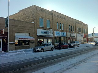
Argyle is a city in Marshall County, Minnesota, United States, along the Middle River. The population was 544 at the 2020 census. Old Mill State Park is nearby.

<span class="mw-page-title-main">Grand Meadow, Minnesota</span> City in Minnesota, United States

Grand Meadow is a city in Mower County, Minnesota, United States. The city is on the boundary between Grand Meadow Township and Frankford Township, and it is politically independent of both townships. The population was 1,127 at the 2020 census.

<span class="mw-page-title-main">Thief River Falls, Minnesota</span> City in Minnesota, United States

Thief River Falls, sometimes referred to as Thief River or abbreviated as TRF, is a city in, and the county seat of, Pennington County in the northwest portion of the U.S. state of Minnesota. The population was 8,749 at the 2020 census.

<span class="mw-page-title-main">Climax, Minnesota</span> City in Minnesota, United States

Climax is a city in Polk County, Minnesota, United States. It is part of the Grand Forks, ND-MN Metropolitan Statistical Area. The population was 243 at the 2020 census.

Crookston Township is a township in Polk County, Minnesota, United States. It is part of the Grand Forks-ND-MN Metropolitan Statistical Area. The population was 554 at the 2000 census.

<span class="mw-page-title-main">East Grand Forks, Minnesota</span> City in Minnesota, United States

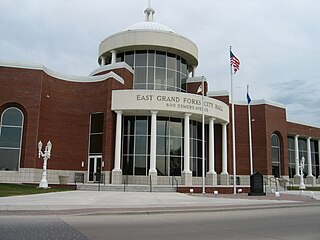
East Grand Forks is a city in Polk County, Minnesota, United States. The population was 9,176 at the 2020 Census, making it the largest community in Polk County.

<span class="mw-page-title-main">Erskine, Minnesota</span> City in Minnesota, United States

Erskine is a city in Polk County, Minnesota. The population was 403 at the time of the 2020 census. It is part of the Greater Grand Forks region.

<span class="mw-page-title-main">Fertile, Minnesota</span> City in Minnesota, United States

Fertile is a city in Polk County, Minnesota, United States. It is part of the Grand Forks ND-MN Metropolitan Statistical Area. The population was 804 at the 2020 census.

<span class="mw-page-title-main">Fisher, Minnesota</span> City in Minnesota, United States

Fisher is a town in Polk County, Minnesota, United States. It is part of the Grand Forks-ND-MN Metropolitan Statistical Area. The population was 422 at the 2020 census. Fisher has become a bedroom community for the nearby Greater Grand Forks Metropolitan Area.

<span class="mw-page-title-main">Fosston, Minnesota</span> City in Minnesota, United States

Fosston is a city in Polk County, Minnesota, United States. It is part of the Greater Grand Forks region. The population was 1,434 at the time of the 2020 census.

<span class="mw-page-title-main">Nielsville, Minnesota</span> City in Minnesota, United States

Nielsville is a city in Polk County, Minnesota, United States. It is part of the Grand Forks, ND-MN Metropolitan Statistical Area. The population was 78 at the 2020 census.

<span class="mw-page-title-main">Cook, Minnesota</span> City in Minnesota, United States

Cook is a city in Saint Louis County, Minnesota, United States. The population was 515 at the 2010 census.

<span class="mw-page-title-main">Mantorville, Minnesota</span> City in Minnesota, United States

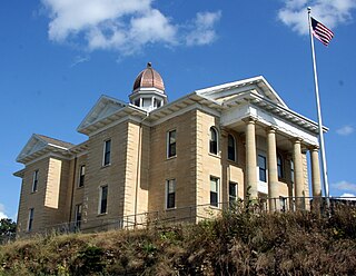
Mantorville is a city in Dodge County, Minnesota, United States. The population was 1,197 at the 2010 census. It is the county seat of Dodge County. Founded in 1854, the city is one of the oldest in Minnesota.

<span class="mw-page-title-main">Thompson, North Dakota</span> City in North Dakota, United States

Thompson is a city in Grand Forks County, North Dakota, United States. It is part of the "Grand Forks, ND-MN Metropolitan Statistical Area" or "Greater Grand Forks". It is located on the border of Allendale and Walle townships, with Walle on the east and Allendale on the west. The population was 1,101 at the 2020 census. Thompson was founded in 1881.

<span class="mw-page-title-main">Reynolds, North Dakota</span> City in North Dakota, United States

Reynolds is a city in Grand Forks and Traill counties in the State of North Dakota. It is part of the Grand Forks, ND-MN Metropolitan Statistical Area or "Greater Grand Forks". The population was 277 at the 2020 census. Reynolds, named for pioneer settler Dr. Henry Reynolds, was founded in 1881.

References

  1. "City Council". City of Crookston, Minnesota. Retrieved April 15, 2024.
  2. 1 2 "2023 U.S. Gazetteer Files". United States Census Bureau. Retrieved July 24, 2022.
  3. 1 2 U.S. Geological Survey Geographic Names Information System: Crookston, Minnesota
  4. 1 2 3 "Explore Census Data". United States Census Bureau . Retrieved April 15, 2024.
  5. 1 2 "City and Town Population Totals: 2020-2022". United States Census Bureau. April 15, 2024. Retrieved April 15, 2024.
  6. "Crookston (MN) sales tax rate" . Retrieved April 15, 2024.
  7. "Find a County". National Association of Counties. Archived from the original on May 31, 2011. Retrieved June 7, 2011.
  8. 1 2 "Crookston Minnesota Community Guide". LakesnWoods. Retrieved April 15, 2024.
  9. "Compendium of History and Biography of Polk County, Minnesota".
  10. 1 2 3 4 Chisholm, Hugh, ed. (1911). "Crookston"  . Encyclopædia Britannica . Vol. 7 (11th ed.). Cambridge University Press. p. 502.
  11. Dokken, Brad (December 24, 2009), "Construction begins on Agassiz trail bridges", Northland Outdoors, archived from the original on July 14, 2011, retrieved March 1, 2011
  12. "NowData - NOAA Online Weather Data". National Oceanic and Atmospheric Administration. Retrieved September 24, 2021.
  13. "Station: Crookston NW EXP STN, MN". U.S. Climate Normals 2020: U.S. Monthly Climate Normals (1991-2020). National Oceanic and Atmospheric Administration. Retrieved September 24, 2021.
  14. "Census of Population and Housing". census.gov. Retrieved June 4, 2015.
  15. "2014 - City of Crookston Study" (PDF). City of Crookston. Archived (PDF) from the original on May 22, 2018. Retrieved May 21, 2018.
  16. "US Census Bureau, Table P16: Household Type". United States Census Bureau. Retrieved April 15, 2024.
  17. "QuickFacts: Crookston city, Minnesota". United States Census Bureau. Retrieved April 15, 2024.
  18. "How many people live in Crookston city, Minnesota". USA Today. Retrieved April 15, 2024.
  19. "Crookston Public School District". National Center for Education Statistics. Retrieved April 15, 2024.
  20. "Brief overview of the history of the U of M Crookston Campus". University of Minnesota Crookston. Retrieved April 15, 2024.
  21. "Quick Facts". University of Minnesota Crookston. Retrieved April 15, 2024.
  22. Helgerson, Brooke. (2010). "The Grand Theater: A Case Study of Architecture and Community." Retrieved from the University of Minnesota Digital Conservancy, December 1, 2017.
  23. "John Noah". Sports Reference. Archived from the original on April 17, 2020. Retrieved December 16, 2016.

47°46′27″N96°36′29″W / 47.77417°N 96.60806°W / 47.77417; -96.60806