In law, an unincorporated area is a region of land that is not governed by a local municipal corporation; similarly an unincorporated community is a settlement that is not governed by its own local municipal corporation, but rather is administered as part of larger administrative divisions, such as a township, parish, borough, county, city, canton, state, province or country. Occasionally, municipalities dissolve or disincorporate, which may happen if they become fiscally insolvent, and services become the responsibility of a higher administration. Widespread unincorporated communities and areas are a distinguishing feature of the United States and Canada. In most other countries of the world, there are either no unincorporated areas at all, or these are very rare; typically remote, outlying, sparsely populated or uninhabited areas.
Godfrey Township is a township in Polk County, Minnesota, United States. It is part of the Grand Forks-ND-MN Metropolitan Statistical Area. The population was 327 at the 2000 census.
Polk County is a county in the U.S. state of Minnesota. The population was 37,600 at the 2010 United States Census. Its county seat is Crookston, and the largest community is East Grand Forks.
Mentor is a city in Polk County, Minnesota, United States. It is part of the Grand Forks-ND-MN Metropolitan Statistical Area. The population was 153 at the 2010 census. The city is located near Maple Lake.
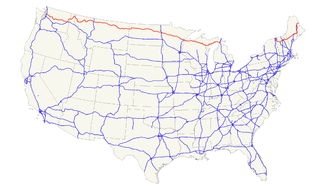
U.S. Route 2 or U.S. Highway 2 (US 2) is an east–west U.S. Highway spanning 2,571 miles (4,138 km) across the northern continental United States. US 2 consists of two segments connected by various roadways in southern Canada. Unlike some routes, which are disconnected into segments because of encroaching Interstate Highways, the two portions of US 2 were designed to be separate in the original 1926 highway plan.
Fertile is a city in Polk County, Minnesota, United States. It is part of the Grand Forks ND-MN Metropolitan Statistical Area. The population was 842 at the 2010 census.
The place name dates back to 1882, when Maple Bay Post Office was established in Markham's general store. At various times, a creamery, two churches, a cheese factory, a blower factory and at least two blacksmith shops as well as several residences, were reported in the small community. Since the 1920s, Maple Bay has evolved into a semi-rural residential area, usually with at least one general store catering to resort and second home residents of the area.
Local lodgings include Ulland's Resort and Campgrounds, Oak Cove Resort, Camp Shalom and Lakeview Resort Restaurant and Lounge (all listed in Mentor, Minnesota yellow pages), as well as the Inn at Maple Crossing. The Maple Lake dance hall and roller rink, constructed in 1913, was no longer in business at last report.
This page is based on this Wikipedia article Text is available under the CC BY-SA 4.0 license; additional terms may apply. Images, videos and audio are available under their respective licenses.
Related Research Articles
The Reedy Creek Improvement District (RCID) is the immediate governing jurisdiction for the land of the Walt Disney World Resort. As of the late 1990s, it comprised an area of 38.6 sq mi (100 km2) within the outer limits of Orange and Osceola counties in Florida. The RCID includes the cities of Bay Lake and Lake Buena Vista, and unincorporated RCID land.
Bay Lake is a city in Orange County, Florida, United States. The population was 47 at the 2010 census. It is named after a lake that lies east of the Magic Kingdom. All four of the Walt Disney World Resort theme parks, and one of Walt Disney World's two water parks, are in Bay Lake, though all Disney parks in the region have mailing addresses in nearby Lake Buena Vista.
Lake Buena Vista is a city in Orange County, Florida, United States. It is mostly known for being the mailing address for Walt Disney World Resort—although almost all of the resort facilities, including all four theme parks, are physically located in the adjacent city of Bay Lake. It is one of two Florida municipalities controlled by The Walt Disney Company, the other being Bay Lake. The permanent residential population of Lake Buena Vista was 10 at the 2010 census.
Algonquin is a village in McHenry and Kane counties, Illinois, in the United States. It is a suburb of Chicago, located approximately 40 miles (64 km) northwest of the Loop. As of the 2010 census the village's population was 30,046, and as of 2017 the estimated population was 31,017.
Erskine is a city in Polk County, Minnesota, United States. The population was 503 at the 2010 census. It is part of the Grand Forks N.D. – Minn. Metropolitan Statistical Area.
Tuxedo is a town located in Orange County, New York along the Ramapo River. As of the 2010 census, the town had a total population of 3,624. The town is in the southeastern part of the county in the Ramapo Mountains. New York State Route 17 and the New York State Thruway pass through the town. The name is derived from a Lenape word tucseto, which has several known meanings.
Bowstring is an unincorporated community in Bowstring Township, Itasca County, Minnesota, United States.
Springwater is a township in central Ontario, Canada, in Simcoe County near Barrie. It is the County seat of Simcoe.
New York State Route 311 (NY 311) is a state highway located entirely within Putnam County, New York, in the United States. The highway begins at NY 52 in Lake Carmel, and intersects Interstate 84 (I-84) shortly thereafter. It crosses NY 164 and NY 292 as it heads into the northeastern part of the county, finally curving east to reach its northern terminus at NY 22 just south of the Dutchess County line. The route passes several historical sites.
Maple Lake is a lake in central Polk County, Minnesota, United States, located 2 miles (3.2 km) due south of Mentor and approximately 4 miles (6.4 km) west of Erskine. The name of the lake is taken from the extensive sugar maple tree forest which surrounds it. Even before American settlement of the region, the existence of these extensive hardwood forests in an otherwise treeless open prairie gave the lake a geographic identity. Maple Lake is a natural lake, and is the westernmost significant lake in the Red River Valley of Northwestern Minnesota. The lake appears on 19th century historic maps of the area, and developed as a summer home and resort community as early as 1910. As a result of drought conditions and low inflows during the 1930s, however, the lake nearly dried up. Beginning in 1940 a two-stage Works Progress Administration development project involving the diversion of water from nearby Badger Lake and the Poplar River raised the lake to its current artificially maintained water level. This rejuvenated the resort industry, and the lake remains a popular summer home, recreational watersports and fishing lake, drawing people from eastern North Dakota and northwestern Minnesota as well as other neighboring states.
Makinen is an unincorporated community in Saint Louis County, Minnesota, United States.
Kabetogama is an unincorporated community in Kabetogama Township, Saint Louis County, Minnesota, United States, located within the Kabetogama State Forest.
Hennepin County, Minnesota, United States maintains a number of county roads, many of them county state aid highways (CSAH). This includes a number of streets through the city of Minneapolis.
Whonnock, British Columbia is a rural, naturally treed, and hilly community on the north side of the Fraser River in the eastern part of the City of Maple Ridge, British Columbia, Canada. It is approximately 56 kilometres east of Downtown Vancouver on the Lougheed Highway Whonnock shares borders with three other Maple Ridge communities. To the west the borders are 256th Street with Albion and upper Kanaka Creek with Webster's Corners. To the east Whonnock Creek forms the border with Ruskin. To the north is the municipal border and to the south the Fraser River.
Maple Springs is an unincorporated community in Pepin Township, Wabasha County, Minnesota, United States, along the Mississippi River and Lake Pepin. The Mississippi River and King Creek meet at Maple Springs.
Day is an unincorporated community in Maple Ridge Township, Isanti County, Minnesota, United States.
The lost towns are a group of places that are still commonly used by county residents. Each was at one time a post office, a store that served a part of the county, a grain elevator used by farmers to ship their crops, or a development that was or may still remain a unique designation. There may be a residential association or some other legal body devoted to the area. More often, these communities are communities of people who still refer to their homes by these geographic designations.
Belmont is an unincorporated community in Spotsylvania County, in the U.S. state of Virginia. It is marked with a highway sign at the intersection of Belmont Road and Orange Springs Road by the Virginia Department of Transportation, however is marked as being the intersection with Belmont Road and Jones Powell Road by the United States Geological Survey (USGS). The immediate area has Fletcher's Store and the Belmont Christmas Tree farm. Further south, there are other buildings identifying with Belmont, such as Belmont Baptist Church, the Belmont Ruritan Community Building where the Belmont Ruritan Club meets each evening at 7 p.m. and serves as the district's polling place for registered voters, and the Belmont Fire & Rescue station manned by Spotsylvania County Volunteer Company 9.
Paytes is an unincorporated community in Spotsylvania County, in the U.S. state of Virginia. The community is marked at the intersection of Lawyer's Road and Catharpin Road by an electrical substation owned by R.E. Lee Electric Company. A telecommunications tower was approved to be built on the site to expand cell coverage in the area on February 28, 2001.
Tucker is an unincorporated community in Anderson County, located within the U.S. state of Texas. According to the Handbook of Texas, the community had a population of 304 in 2000. It is located within the Palestine, Texas micropolitan area.