Dugdale, Minnesota

Last updated
Dugdale, Minnesota
Unincorporated community
USA Minnesota location map.svg
Red pog.svg
Dugdale, Minnesota
Usa edcp location map.svg
Red pog.svg
Dugdale, Minnesota
Coordinates: 47°42′06″N96°15′59″W / 47.70167°N 96.26639°W / 47.70167; -96.26639 Coordinates: 47°42′06″N96°15′59″W / 47.70167°N 96.26639°W / 47.70167; -96.26639
Country United States
State Minnesota
County Polk
Elevation 1,138 ft (347 m)
Time zone Central (CST) (UTC-6)
  Summer (DST) CDT (UTC-5)
Area code(s) 218
GNIS feature ID 654680 [1]

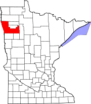
Dugdale is an unincorporated community in Polk County, Minnesota, United States. [1] Dugdale is located at 47°42′06″N96°15′59″W / 47.70167°N 96.26639°W / 47.70167; -96.26639 .

Unincorporated area Region of land not governed by own local government

In law, an unincorporated area is a region of land that is not governed by a local municipal corporation; similarly an unincorporated community is a settlement that is not governed by its own local municipal corporation, but rather is administered as part of larger administrative divisions, such as a township, parish, borough, county, city, canton, state, province or country. Occasionally, municipalities dissolve or disincorporate, which may happen if they become fiscally insolvent, and services become the responsibility of a higher administration. Widespread unincorporated communities and areas are a distinguishing feature of the United States and Canada. In most other countries of the world, there are either no unincorporated areas at all, or these are very rare; typically remote, outlying, sparsely populated or uninhabited areas.

Polk County, Minnesota County in the United States

Polk County is a county in the U.S. state of Minnesota. The population was 37,600 at the 2010 United States Census. Its county seat is Crookston, and the largest community is East Grand Forks.

Minnesota State of the United States of America

Minnesota is a state in the Upper Midwest and northern regions of the United States. Minnesota was admitted as the 32nd U.S. state on May 11, 1858, created from the eastern half of the Minnesota Territory. The state has a large number of lakes, and is known by the slogan the "Land of 10,000 Lakes". Its official motto is L'Étoile du Nord.

The community is located east of Crookston and south of Red Lake Falls on Minnesota State Highway 32.

Crookston, Minnesota City in Minnesota, United States

Crookston is a city in the U.S. state of Minnesota. It is the county seat of Polk County. The population was 7,891 at the 2010 census. It is part of the "Grand Forks, ND–MN Metropolitan Statistical Area" or "Greater Grand Forks".

Red Lake Falls, Minnesota City in Minnesota, United States

Red Lake Falls is a city in Red Lake County, Minnesota, United States. The population was 1,427 at the 2010 census. It is the county seat of Red Lake County. The city lies in the middle of Red Lake Falls Township from which it was separated when incorporated as a village in 1881. Its status was raised to that of a city in 1898.

Minnesota State Highway 32 (MN 32) is a highway in west-central and northwest Minnesota, which runs from its intersection with State Highway 34 in Tansem Township near Barnesville and continues north to its intersection with State Highway 11 at Greenbush in Roseau County.

A post office called Dugdale was established in 1884, and remained in operation until 1927. [2] Dugdale had a depot on the railroad. [3]

Related Research Articles

Red Lake County, Minnesota County in the United States

Red Lake County is a county located in the U.S. state of Minnesota. As of the 2010 census, the population was 4,089, making it the third-least populous county in Minnesota. Its county seat is Red Lake Falls.

Fertile, Minnesota City in Minnesota, United States

Fertile is a city in Polk County, Minnesota, United States. It is part of the Grand Forks ND-MN Metropolitan Statistical Area. The population was 842 at the 2010 census.

Mentor, Minnesota City in Minnesota, United States

Mentor is a city in Polk County, Minnesota, United States. It is part of the Grand Forks-ND-MN Metropolitan Statistical Area. The population was 153 at the 2010 census. The city is located near Maple Lake.

Hagemans Crossing, Ohio human settlement in United States of America

Hagemans Crossing is an unincorporated community in Union Township, Warren County, Ohio, United States. Located in the western part of the township, it is located on the old Cincinnati and Xenia Pike, now U.S. Route 42, about halfway between Lebanon and Mason. It was at the crossing of the Middletown and Cincinnati Railroad and the Cincinnati, Lebanon and Northern Railway and was about two miles northwest of the M&C's eastern terminus at Middletown Junction.

Beresford, New Brunswick Town in New Brunswick, Canada

Beresford is a Canadian town in Gloucester County, New Brunswick.

Caverna is an unincorporated community in southern McDonald County, Missouri, United States. It is located on U.S. Route 71, immediately north of the Missouri-Arkansas state line, opposite Bella Vista. Several businesses are located there. It is part of the Fayetteville–Springdale–Rogers, AR-MO Metropolitan Statistical Area.

Williamsburg, Missouri unincorporated community in Missouri

Williamsburg is an unincorporated community in eastern Callaway County, Missouri, United States. It is located on Missouri Supplemental Route D just north of Interstate 70, approximately thirteen miles northeast of Fulton. The Whetstone Creek Conservation Area along Whetstone Creek lies about one mile to the north.

Sand Hill River river in the United States of America

The Sand Hill River is a 101-mile-long (163 km) tributary of the Red River of the North in northwestern Minnesota in the United States. Via the Red River, Lake Winnipeg, and the Nelson River, it is part of the watershed of Hudson Bay, and drains an area of 475 square miles (1,230 km2).

Cookstown is an unincorporated community in Spotsylvania County, in the U.S. state of Virginia.

Hinesville is an unincorporated community in Pittsylvania County, in the U.S. state of Virginia.

Champepadan Creek is a stream in the U.S. state of Minnesota.

Badger Lake is a lake in Polk County, in the U.S. state of Minnesota.

Union Lake is a lake in Polk County, in the U.S. state of Minnesota.

Crystal Lake is a lake in Polk County, in the U.S. state of Minnesota.

Cameron Lake is a lake in Polk County, in the U.S. state of Minnesota.

Lake Arthur is a lake in Polk County, near the town of Fertile in the U.S. state of Minnesota.

Turtle Lake is a lake in Polk County, in the U.S. state of Minnesota.

Spring Lake (Scott County, Minnesota)

Spring Lake is a lake in Scott County, in the U.S. state of Minnesota.

America, Indiana Unincorporated community in Indiana, United States

America is an unincorporated community in Liberty Township, Wabash County, in the U.S. state of Indiana.

References

  1. 1 2 U.S. Geological Survey Geographic Names Information System: Dugdale, Minnesota
  2. "Polk County". Jim Forte Postal History. Retrieved 31 July 2015.
  3. Upham, Warren (1920). Minnesota Geographic Names: Their Origin and Historic Significance. Minnesota Historical Society. p. 423.