Jackson, Minnesota | |
---|---|
Motto: "Come Grow With Us" | |
Coordinates: 43°37′15″N94°59′19″W / 43.62083°N 94.98861°W | |
Country | United States |
State | Minnesota |
County | Jackson |
Government | |
• Type | Mayor – Council |
• Mayor | Marcus Polz |
Area | |
• Total | 5.22 sq mi (13.53 km2) |
• Land | 5.19 sq mi (13.45 km2) |
• Water | 0.03 sq mi (0.08 km2) |
Elevation | 1,312 ft (400 m) |
Population (2020) | |
• Total | 3,323 |
• Density | 640.15/sq mi (247.14/km2) |
Time zone | UTC-6 (Central (CST)) |
• Summer (DST) | UTC-5 (CDT) |
ZIP code | 56143 |
Area code | 507 |
FIPS code | 27-31562 [3] |
GNIS feature ID | 2395448 [2] |
Website | cityofjacksonmn.com |
Jackson is a city and county seat of Jackson County, Minnesota, United States. [4] The population was 3,299 at the 2010 census. [5]
For centuries, many indigenous peoples called this area home, including the Cheyenne, Ioway, and Dakota tribes. In 1851, the Treaty of Traverse des Sioux opened the region to white settlement in exchange for payments from the government.
Jackson was originally called Springfield, and under the latter name was laid out in 1856. [6] The first settlers in what is now Jackson County - William, George, and Charles Wood - established a trading post near the Des Moines River, around the same time. A post office called Jackson has been in operation since 1858. [7]
On March 26, 1857 the Wahpekute Dakota Chief Inkpaduta and his band attacked the settlement heading north after the Spirit Lake Massacre. There were 11 able bodied men in Springfield and three men, three children and one woman died as a result. Lost to the raiders were 12 horses, dry goods, lead and powder. The sole survivor of the Spirit Lake attack was 14 year old Abbie Gardner and was present. Terrified of a possible second attack, the beleaguered survivors abandoned the area.
Two months later, the Minnesota State Legislature organized the area into a county, naming it after Saint Paul merchant Henry Jackson. The temporary county seat was located at the townsite of Springfield, now renamed Jackson. The area was still depopulated, however, and resettlement was slow due to continued hostility. In August 1862, the Dakota, angry at late payments from the government, skirmished with settlers; one such skirmish compelled some Dakota leaders to attack government buildings in the Minnesota River, starting the US-Dakota War. By August 24, the effects of the war had reached Jackson County. Warriors raided a community of Norwegian immigrants in Belmont Township north of Jackson, killing thirteen and wounding three. As in 1857, the remaining settlers fled, leaving Jackson County depopulated once more.
After the Civil War, resettlement in Jackson County began again. A stockade was built on the east side of the river, encouraging further immigration. These immigrants primarily came from Northern and Central Europe. They built their homes from native timber and prairie sod. Life remained difficult; there were no wagon roads, no bridges, no churches, and only one school that served the community. The threat of attack remained, and the region was susceptible to numerous disasters including prairie fire, severe blizzards, crop failures, and plagues of grasshoppers. Despite such hardship, these hardy, courageous pioneers survived and helped establish the prosperous agricultural and industrial community that Jackson is today. [8]
According to the United States Census Bureau, the city has a total area of 4.60 square miles (11.91 km2), of which 4.58 square miles (11.86 km2) is land and 0.02 square miles (0.05 km2) is water. [9]
The city lies along Interstate 90, which runs east to west the entire width of southern Minnesota. Interstate 90 and U.S. Highway 71 are two of the main routes in the city. Jackson is located near the center of the county of the same name. To the south is the Iowa Lakes region, which comprises Spirit Lake, West Okoboji Lake and several other small lakes.
Census | Pop. | Note | %± |
---|---|---|---|
1880 | 501 | — | |
1890 | 720 | 43.7% | |
1900 | 1,756 | 143.9% | |
1910 | 1,907 | 8.6% | |
1920 | 2,144 | 12.4% | |
1930 | 2,206 | 2.9% | |
1940 | 2,840 | 28.7% | |
1950 | 3,313 | 16.7% | |
1960 | 3,370 | 1.7% | |
1970 | 3,550 | 5.3% | |
1980 | 3,797 | 7.0% | |
1990 | 3,559 | −6.3% | |
2000 | 3,501 | −1.6% | |
2010 | 3,299 | −5.8% | |
2020 | 3,323 | 0.7% | |
U.S. Decennial Census |
As of the census [10] of 2010, there were 3,299 people, 1,489 households, and 856 families living in the city. The population density was 720.3 inhabitants per square mile (278.1/km2). There were 1,635 housing units at an average density of 357.0 per square mile (137.8/km2). The racial makeup of the city was 93.3% White, 0.5% African American, 0.4% Native American, 3.4% Asian, 0.8% from other races, and 1.6% from two or more races. Hispanic or Latino of any race were 1.8% of the population.
There were 1,509 households, of which 27.2% had children under the age of 18 living with them, 42.6% were married couples living together, 10.3% had a female householder with no husband present, 4.5% had a male householder with no wife present, and 42.5% were non-families. 37.9% of all households were made up of individuals, and 16.1% had someone living alone who was 65 years of age or older. The average household size was 2.17 and the average family size was 2.84.
The median age in the city was 40.8 years. 22.7% of residents were under the age of 18; 8.4% were between the ages of 18 and 24; 23.1% were from 25 to 44; 26.4% were from 45 to 64; and 19.3% were 65 years of age or older. The gender makeup of the city was 48.4% male and 51.6% female.
As of the census [3] of 2000, there were 3,501 people, 1,487 households, and 887 families living in the city. The population density was 921.7 inhabitants per square mile (355.9/km2). There were 1,659 housing units at an average density of 436.8 per square mile (168.6/km2). The racial makeup of the city was 94.03% White, 0.26% African American, 0.17% Native American, 4.03% Asian, 0.77% from other races, and 0.74% from two or more races. Hispanic or Latino of any race were 1.51% of the population.
There were 1,487 households, out of which 27.2% had children under the age of 18 living with them, 49.0% were married couples living together, 7.9% had a female householder with no husband present, and 40.3% were non-families. 36.3% of all households were made up of individuals, and 16.5% had someone living alone who was 65 years of age or older. The average household size was 2.24 and the average family size was 2.93.
In the city, the population was spread out, with 23.3% under the age of 18, 9.5% from 18 to 24, 24.5% from 25 to 44, 20.5% from 45 to 64, and 22.2% who were 65 years of age or older. The median age was 40 years. For every 100 females, there were 94.2 males. For every 100 females age 18 and over, there were 89.8 males.
The median income for a household in the city was $33,452, and the median income for a family was $42,553. Males had a median income of $30,503 versus $21,676 for females. The per capita income for the city was $18,444. About 4.6% of families and 11.1% of the population were below the poverty line, including 17.4% of those under age 18 and 9.4% of those age 65 or over.
Though largely a farming community, Jackson has a large industrial park with such businesses as: AGCO, Last-Deck, USF Holland, New Fashion Pork, HitchDoc, and Pioneer. AGCO and Challenger tractors are manufactured in Jackson.
Jackson is located in Minnesota's 1st congressional district, represented by Republican Brad Finstad. At the state level, Jackson is located in Senate District 22, represented by Republican Doug Magnus, and in House District 22B, represented by Republican Brian Pfarr. [11]
The city-owned Jackson Municipal Airport is located 2.3 miles (3.7 km) north of Jackson's central business district. [12]
Channel | Callsign | Affiliation | Branding | Subchannels | Owner | |
---|---|---|---|---|---|---|
(Virtual) | Channel | Programming | ||||
2.1 | K22MY-D (KTCA Translator) | PBS | TPT 2 | 2.2 | Minnesota Channel | Cooperative Television Association of Southern Minnesota |
2.4 | PBS Kids | |||||
4.1 | K35IZ-D | CBS | WCCO 4 | 4.2 | Start TV | Cooperative Television Association of Southern Minnesota |
17.1 | Youtoo America | |||||
18.1 | Laff | |||||
5.1 | K17MY-D (KSTP Translator) | ABC | 5 Eyewitness News | 5.7 | Heroes & Icons | Cooperative Television Association of Southern Minnesota |
5.2 | K29LV-D (KSTC Translator) | Ind. | 45 TV | 5.3 | MeTV | Cooperative Television Association of Southern Minnesota |
5.4 | Antenna TV | |||||
5.6 | This TV | |||||
9.2 | K34NU-D (WFTC Translator) | Ind. | FOX 9 Plus | 9.3 | Movies! | Cooperative Television Association of Southern Minnesota |
9.1 | FOX | |||||
11.4 | K19HZ-D (KARE Translator) | NBC | KARE 11 | 11.5 | Court TV | Cooperative Television Association of Southern Minnesota |
11.6 | True Crime Network | |||||
11.7 | Quest | |||||
16.1 | K23FO-D | Coop TV | 16.2 | The Action Channel | Cooperative Television Association of Southern Minnesota | |
16.3 | Heartland | |||||
16.4 | AMG TV | |||||
16.5 | Biz TV | |||||
23.5 | Grit | |||||
23.1 | K28OI-D (WUCW Translator) | CW | CW 23 | 23.2 | Comet | Cooperative Television Association of Southern Minnesota |
23.3 | Charge! | |||||
23.4 | TBD | |||||
41.1 | K30KQ-D (KPXM Translator) | ION | ION | 41.2 | Qubo | Cooperative Television Association of Southern Minnesota |
41.3 | Ion Plus | |||||
41.4 | ION Shop | |||||
41.5 | QVC | |||||
41.6 | HSN |
Roberts County is a county in the U.S. state of South Dakota. As of the 2020 census, the population was 10,280. Its county seat is Sisseton. The county was named either for S. G. Roberts of Fargo, North Dakota, or for Solomon Robar, an early local French fur trader. It was created on March 8, 1883, and fully organized by August 6 of that year. Its boundary was altered once, in 1885.
Moody County is a county in the U.S. state of South Dakota, United States. The population was 6,336 at the 2020 census. Its county seat is Flandreau. The county is named for Gideon C. Moody.
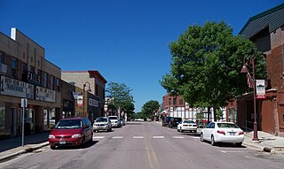
Grant County is a county in the U.S. state of South Dakota. As of the 2020 census, the population was 7,556. The county seat is Milbank. The county was founded in 1873 and organized in 1878. It is named for Ulysses S. Grant, 18th President of the United States.
Riverton is a city in Crow Wing County, Minnesota, United States. The population was 117 at the 2010 census. It is part of the Brainerd Micropolitan Statistical Area.
Randolph is a city in Dakota County, Minnesota, United States. The population was 436 at the 2010 census.
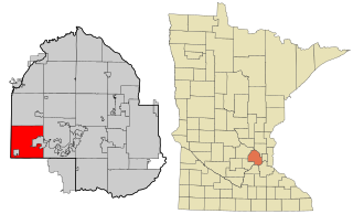
Minnetrista is a city in Hennepin County, Minnesota, United States. It is located about 23 miles (37 km) west of Minneapolis. Although it is part of the Minneapolis–Saint Paul metropolitan area, the largely rural Minnetrista has agricultural activity involving corn, soybeans, hay, and horses. In addition to farmland and woods, the city is home to several lakes, including part of Lake Minnetonka, the state's ninth-biggest. The city's population was 6,384 at the 2010 census. Minnetrista's name originates in the Dakota language, in which minne means "water" and trista means "crooked".
Isanti is a city in Isanti County, Minnesota, United States. The population was 6,804 at the 2020 census. The name Isanti is composed of two Dakota words: isan ("knife") and ati ("camp"), and refers to the Santee Dakota people.
Heron Lake is a city in Jackson County, Minnesota, United States. The population was 698 at the 2010 census.
Lakefield is a city in Jackson County, Minnesota, United States. The population was 1,694 at the 2010 census.
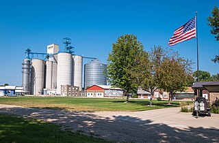
Mahnomen is a city in Mahnomen County, Minnesota, United States, along the Wild Rice River. The population was 1,240 at the 2020 census. It is the seat of Mahnomen County.
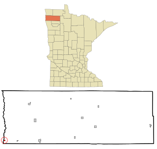
Oslo is a city in Marshall County, Minnesota, United States. The population was 239 at the 2020 census.
Sturgeon Lake is a city in Pine County, Minnesota, United States. The population was 439 at the 2010 census.
Starbuck is a city in Pope County, Minnesota, United States. The population was 1,365 at the 2020 census. The city is on the western shore of Lake Minnewaska.
Dakota is a city in Winona County, Minnesota, United States. The population was 295 at the 2020 census.
Paynesville is a city in Stearns County, Minnesota, United States, on Lake Koronis, in the central part of the state. The population was 2,388 at the 2020 census. It is part of the St. Cloud Metropolitan Statistical Area.
Big Stone City is a city in the northeastern corner of Grant County, South Dakota, United States, that lies between the southern tip of Big Stone Lake and the northern bank of the Whetstone River, and is adjacent to the city of Ortonville, Minnesota. The population was 412 at the 2020 census.
Kadoka is a city in, and the county seat of, Jackson County, South Dakota, United States. The population was 543 at the 2020 census. The town occupies about 2.3 square miles.
Minnesota Lake is a city in Blue Earth and Faribault counties in the State of Minnesota. The population was 661 at the 2020 census. The bulk of the city is in Faribault County; a small part extends into Blue Earth County.
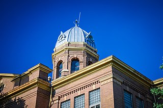
Redwood Falls is a city in Redwood County, located along the Redwood River near its confluence with the Minnesota River, in the U.S. state of Minnesota. The population was 5,102 at the 2020 census. It is the county seat.
Shakopee is a city in and the county seat of Scott County, Minnesota, United States. It is southwest of Minneapolis. Sited on the south bank bend of the Minnesota River, Shakopee and nearby suburbs comprise the southwest portion of Minneapolis-Saint Paul, the nation's 16th-largest metropolitan area, with 3.7 million people. The population was 43,698 at the 2020 census.