Todd County, Minnesota

Last updated

Todd County
Todd County Courthouse.jpg
The Todd County Courthouse in Long Prairie
Map of Minnesota highlighting Todd County.svg
Location within the U.S. state of Minnesota
Minnesota in United States.svg
Minnesota's location within the U.S.
Coordinates: 46°04′N94°54′W / 46.07°N 94.9°W / 46.07; -94.9
CountryFlag of the United States.svg United States
StateFlag of Minnesota.svg  Minnesota
FoundedFebruary 20, 1855 (created)
January 1, 1867 (organized)
Named for John Blair Smith Todd
Seat Long Prairie
Largest cityLong Prairie
Area
  Total980 sq mi (2,500 km2)
  Land945 sq mi (2,450 km2)
  Water35 sq mi (90 km2)  3.5%
Population
 (2020)
  Total25,262
  Estimate 
(2023)
25,667 Increase2.svg
  Density26/sq mi (10.0/km2)
Time zone UTC−6 (Central)
  Summer (DST) UTC−5 (CDT)
Congressional district 7th
Website www.co.todd.mn.us

Todd County is a county in the central part of the U.S. state of Minnesota. As of the 2020 census, the population was 25,262. [1] Its county seat is Long Prairie. [2]

Contents

History

The county was created by the Minnesota Territorial legislature on February 20, 1855, although the county government was not organized until January 1, 1867, with Long Prairie as the county seat. It was named for John Blair Smith Todd, who was a delegate from Dakota Territory to the United States House of Representatives, and general in the Union Army during the American Civil War. [3]

In 1976 the Todd County Bicentennial Commission compiled an extensive history of the County in a 316 page spiral bound book. The book includes histories of Todd County Villages, townships, and forgotten post offices, among other items. [4]

Geography

The Crow Wing River flows southeastward along the northeastern border of Todd County. The Long Prairie River flows east-northeast through the central part of the county, discharging into the Crow Wing on the county's northeastern border. [5] The Wing River, northwest of the Long Prairie River, also flows into the Crow Wing. The county terrain consists of rolling hills, dotted with lakes and etched with drainages. The area is devoted to agriculture. [6] The terrain slopes to the east and south, with its highest point on the west border at 1,483 ft (452 m) ASL. [7] The county has a total area of 980 sq mi (2,500 km2), of which 945 sq mi (2,450 km2) is land and 35 sq mi (91 km2)(3.5%) is water. [8]

Soils of Todd County Todd Co Pie Chart 2-20-18 Wiki Version.pdf
Soils of Todd County

Major highways

Adjacent counties

Lakes [6]

  • Bass Lake
  • Beauty Lake
  • Big Birch Lake (part)
  • Big Lake
  • Big Swan Lake
  • Buckhorn Lake
  • Bunker Lake
  • Cedar Lake
  • Charlotte Lake
  • Coal Lake
  • Fairly Lake
  • Fawn Lake
  • Felix Lake
  • Goose Lake
  • Guernsey Lake
  • Hayden Lake
  • Horseshoe Lake
  • Juergens Lake
  • Keller Lake
  • Lady Lake
  • Lake Osakis (part)
  • Latimer Lake
  • Lawrence Lake
  • Little Birch Lake (part)
  • Little Sauk Lake
  • Long Lake (Birchdale Twp.)
  • Long Lake (Burnhamville Twp.)
  • Maple Lake
  • Mary Lake (part)
  • McCarrahan Lake
  • Mill Lake
  • Mound Lake
  • Mud Lake
  • Pauley Lake
  • Pendergast Lake
  • Pine Island Lake
  • Rice Lake
  • Sauk Lake (part)
  • Schreiers Lake
  • Sheet Lake
  • Trace Lake
  • Twin Lakes (part)
  • West Union Lake

Protected areas [6]

  • Aurzada Wildlife Management Area
  • Buckhorn Lake State Wildlife Management Area
  • Burleene State Wildlife Management Area
  • Dower State Wildlife Management Area
  • Elgin Woods Wildlife Management Area
  • Iona Wildlife Management Area
  • Ireland State Wildlife Management Area
  • Long Prairie River Wildlife Management Area
  • Oak Ridge State Wildlife Management Area
  • Ojakis Wildlife Management Area (part)
  • Owen-Hinz Wildlife Management Area
  • Quistorff Wildlife Management Area
  • Randall State Wildlife Management Area
  • Santer Wildlife Management Area
  • Sheet Lake Wildlife Management Area
  • West Union Wildlife Management Area

Demographics

Historical population
CensusPop.Note
1860 430
1870 2,036373.5%
1880 6,133201.2%
1890 12,930110.8%
1900 22,21471.8%
1910 23,4075.4%
1920 26,05911.3%
1930 26,1700.4%
1940 27,4384.8%
1950 25,420−7.4%
1960 23,119−9.1%
1970 22,114−4.3%
1980 24,99113.0%
1990 23,363−6.5%
2000 24,4264.5%
2010 24,8951.9%
2020 25,2621.5%
2023 (est.)25,667 [10] 1.6%
U.S. Decennial Census [11]
1790-1960 [12] 1900-1990 [13]
1990-2000 [14] 2010-2020 [1]

2020 Census

Todd County Racial Composition [15]
RaceNum.Perc.
White (NH)22,11787.55%
Black or African American (NH)950.37%
Native American (NH)760.3%
Asian (NH)970.38%
Pacific Islander (NH)720.29%
Other/Mixed (NH)5972.36%
Hispanic or Latino 2,2088.74%

2000 census

2022 US Census population pyramid for Todd County, from ACS 5-year estimates ToddCountyMn2022PopPyr.png
2022 US Census population pyramid for Todd County, from ACS 5-year estimates

As of the census of 2000, there were 24,426 people, 9,342 households, and 6,511 families in Todd County. The population density was 25.8 per square mile (10.0/km2). There were 11,900 housing units at an average density of 12.6 per square mile (4.9/km2). The racial makeup of the county was 97.54% White, 0.11% Black or African American, 0.48% Native American, 0.31% Asian, 0.01% Pacific Islander, 0.72% from other races, and 0.82% from two or more races. 1.90% of the population were Hispanic or Latino of any race. 52.1% were of German, 11.3% Norwegian and 5.6% Polish ancestry.

There were 9,342 households, out of which 31.80% had children under the age of 18 living with them, 59.80% were married couples living together, 6.10% had a female householder with no husband present, and 30.30% were non-families. 26.30% of all households were made up of individuals, and 13.00% had someone living alone who was 65 years of age or older. The average household size was 2.58 and the average family size was 3.14.

The county population contained 27.40% under the age of 18, 8.10% from 18 to 24, 24.70% from 25 to 44, 23.80% from 45 to 64, and 16.10% who were 65 years of age or older. The median age was 38 years. For every 100 females there were 101.80 males. For every 100 females age 18 and over, there were 102.00 males.

The median income for a household in the county was $32,281, and the median income for a family was $39,920. Males had a median income of $28,630 versus $20,287 for females. The per capita income for the county was $15,658. About 9.60% of families and 12.90% of the population were below the poverty line, including 14.60% of those under age 18 and 13.50% of those age 65 or over.

Amish

Todd County has a large concentration of Amish, about the same population size as the Amish settlement at Harmony. [16] It is home to five different Amish communities, with altogether seven church districts in 2013, which indicates a total population of about 1000 people.

LocationFounded inChurch dis-
tricts in 2013
Affiliation
Bertha/Hewitt19731 Swartzentruber
Long Prairie/Osakis19952
Clarissa/Browerville20012
Bertha/Staples20031Swartzentruber
Eagle Bend20071

[17]

Communities

Cities

Unincorporated communities

Townships

Government and politics

Todd County voters tend to vote Republican. In 71% of national elections since 1960, the county selected the Republican Party candidate (as of 2020). In both 2016 and 2020, Todd County was Donald Trump's second strongest county in Minnesota behind neighboring Morrison County both times.

United States presidential election results for Todd County, Minnesota [18]
Year Republican Democratic Third party
No.%No.%No.%
2020 9,75373.57%3,28624.79%2181.64%
2016 8,48570.75%2,78323.21%7256.05%
2012 6,71956.93%4,81940.83%2652.25%
2008 6,63754.15%5,27743.05%3432.80%
2004 6,94556.86%5,03441.21%2351.92%
2000 6,03154.37%4,13237.25%9298.38%
1996 4,07838.11%4,52042.24%2,10319.65%
1992 3,99035.93%4,05936.55%3,05527.51%
1988 5,63352.40%5,02346.73%940.87%
1984 6,58558.25%4,65741.19%630.56%
1980 6,45153.27%4,97541.08%6855.66%
1976 4,27838.03%6,53058.05%4403.91%
1972 5,38753.14%4,27042.12%4804.74%
1968 4,88351.62%3,99242.20%5856.18%
1964 4,00641.29%5,67358.47%230.24%
1960 5,25550.85%5,05148.88%280.27%
1956 5,07556.51%3,88243.22%240.27%
1952 6,73165.92%3,43933.68%410.40%
1948 4,16643.69%5,15754.08%2122.22%
1944 5,63659.37%3,80340.06%540.57%
1940 6,30257.73%4,55341.71%610.56%
1936 3,78037.79%5,62756.26%5955.95%
1932 3,11433.17%6,02364.16%2502.66%
1928 5,68259.81%3,73339.29%850.89%
1924 4,44153.00%5576.65%3,38140.35%
1920 5,44871.10%1,46419.11%7509.79%
1916 1,91944.50%1,92244.57%47110.92%
1912 1,03827.76%1,06828.56%1,63343.67%
1908 2,33457.37%1,30532.08%42910.55%
1904 2,96174.83%74118.73%2556.44%
1900 2,21256.28%1,48737.84%2315.88%
1896 2,04352.28%1,73944.50%1263.22%
1892 1,25142.09%1,11837.62%60320.29%
County Board of Commissioners [19]
PositionNameDistrictNext Election
Commissioner and Vice chairBarb BeckerDistrict 12024
CommissionerTim DennyDistrict 22026
CommissionerRod EricksonDistrict 32024
CommissionerLew NoskaDistrict 42026
Commissioner and ChairpersonRandy NeumannDistrict 52024
State Legislature (2018-2020)
PositionNameAffiliationDistrict
Senate Paul Gazelka [20] Republican District 9
House of Representatives John Poston [21] Republican District 9A
House of Representatives Ron Kresha [22] Republican District 9B
U.S Congress (2018-2020)
PositionNameAffiliationDistrict
House of Representatives Collin Peterson [23] Democrat 7th
Senate Amy Klobuchar [24] Democrat N/A
Senate Tina Smith [25] Democrat N/A

See also

Related Research Articles

<span class="mw-page-title-main">Yellow Medicine County, Minnesota</span> County in Minnesota, United States

Yellow Medicine County is a county in the southwestern part of the U.S. state of Minnesota. Its eastern border is formed by the Minnesota River. As of the 2020 census, the population was 9,528. Its county seat is Granite Falls.

<span class="mw-page-title-main">Wadena County, Minnesota</span> County in Minnesota, United States

Wadena County is a county in the U.S. state of Minnesota. As of the 2020 census, the population was 14,065. Its county seat is Wadena.

<span class="mw-page-title-main">Stearns County, Minnesota</span> County in Minnesota, United States

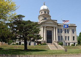
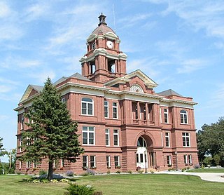
Stearns County is a county in the U.S. state of Minnesota. As of the 2020 census, the population was 158,292. Its county seat and largest city is St. Cloud.

<span class="mw-page-title-main">Sherburne County, Minnesota</span> County in Minnesota, United States

Sherburne County is a county in Central Minnesota. At the 2020 census, the population was 97,183. The county seat is Elk River.

<span class="mw-page-title-main">Pope County, Minnesota</span> County in Minnesota, United States

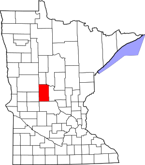
Pope County is a county in the U.S. state of Minnesota. As of the 2020 census, the population was 11,308. Its county seat is Glenwood. The county was formed in 1862 and organized in 1866.

<span class="mw-page-title-main">Polk County, Minnesota</span> County in Minnesota, United States

Polk County is a county in the northwestern part of the U.S. state of Minnesota. The population was 31,192 at the 2020 census. Its county seat is Crookston, and the largest community is East Grand Forks.

<span class="mw-page-title-main">Pipestone County, Minnesota</span> County in Minnesota, United States

Pipestone County is a county in the U.S. state of Minnesota. As of the 2020 census, the population was 9,424. Its county seat is Pipestone.

<span class="mw-page-title-main">Norman County, Minnesota</span> County in Minnesota, United States

Norman County is a county in the northwestern part of the U.S. state of Minnesota. As of the 2020 census, the population was 6,441. Its county seat is Ada. The county is in Minnesota's Red River Valley region.

<span class="mw-page-title-main">Nobles County, Minnesota</span> County in Minnesota, United States

Nobles County is a county in the U.S. state of Minnesota. As of the 2020 census, the population was 22,290. Its county seat is Worthington. Nobles County comprises the Worthington, MN Micropolitan Statistical Area.

<span class="mw-page-title-main">Murray County, Minnesota</span> County in Minnesota, United States

Murray County is a county in the U.S. state of Minnesota. The population was 8,179 at the 2020 census. Its county seat is Slayton.

<span class="mw-page-title-main">Morrison County, Minnesota</span> County in Minnesota, United States

Morrison County is a county in the U.S. state of Minnesota. As of the 2020 census, the population was 34,010. Its county seat is Little Falls. Camp Ripley Military Reservation occupies a significant area in north-central Morrison County.

<span class="mw-page-title-main">Mahnomen County, Minnesota</span> County in Minnesota, United States

Mahnomen County is a county in the U.S. state of Minnesota. As of the 2020 census, the population was 5,411. Its county seat is Mahnomen.

<span class="mw-page-title-main">Lincoln County, Minnesota</span> County in Minnesota, United States

Lincoln County is a county in the U.S. state of Minnesota. As of the 2020 census, the population was 5,640. Its county seat is Ivanhoe.

<span class="mw-page-title-main">Jackson County, Minnesota</span> County in Minnesota, United States

Jackson County is a county in the U.S. state of Minnesota. As of the 2020 census, the population was 9,989. Its county seat is Jackson.

<span class="mw-page-title-main">Grant County, Minnesota</span> County in Minnesota, United States

Grant County is a county in the U.S. state of Minnesota. As of the 2020 census, the population was 6,074. Its county seat is Elbow Lake.

<span class="mw-page-title-main">Goodhue County, Minnesota</span> County in Minnesota, United States

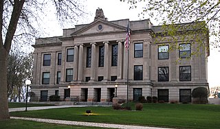
Goodhue County is a county in the U.S. state of Minnesota. As of the 2020 census, the population was 47,582. Its county seat is Red Wing. Nearly all of Prairie Island Indian Community is within the county.

<span class="mw-page-title-main">Douglas County, Minnesota</span> County in Minnesota, United States

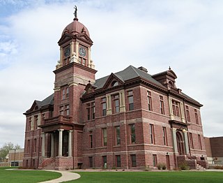
Douglas County is a county in the U.S. state of Minnesota. As of the 2020 census, the population was 39,006. Its county seat is Alexandria.

<span class="mw-page-title-main">Clearwater County, Minnesota</span> County in Minnesota, United States

Clearwater County is a county in the northwestern part of the U.S. state of Minnesota. As of the 2020 census, the population was 8,524. Its county seat is Bagley.

<span class="mw-page-title-main">Benton County, Minnesota</span> County in Minnesota, United States

Benton County is a county in the East Central part of the U.S. state of Minnesota. As of the 2020 census, the population was 41,379. Its county seat is Foley.

<span class="mw-page-title-main">Aitkin County, Minnesota</span> County in Minnesota, United States

Aitkin County is a county in the U.S. state of Minnesota. As of the 2020 census, the population was 15,697. Its county seat is Aitkin. Part of the Mille Lacs Indian Reservation is in the county. The county was created in 1857 and organized in 1871.

References

  1. 1 2 "State & County QuickFacts". United States Census Bureau. Retrieved April 10, 2023.
  2. "Find a County". National Association of Counties. Retrieved June 7, 2011.
  3. Upham, Warren (1920). Minnesota Geographic Names: Their Origin and Historic Significance. Minnesota Historical Society. p.  543 . Retrieved March 14, 2019.
  4. Downes, James (July 1976). Todd County Histories. Long Prairie, MN: Todd County Bicentennial Commission. pp. Title page.
  5. Sandy, John H. (2022). "Long Prairie River Region: Natural Environment and Land Use". Red River Nature Research Institute. Retrieved March 12, 2022.
  6. 1 2 3 Todd County MN Google Maps (accessed March 14, 2019)
  7. "Find an Altitude/Todd County MN" Google Maps (accessed March 14, 2019)
  8. "2010 Census Gazetteer Files". United States Census Bureau. August 22, 2012. Archived from the original on October 6, 2014. Retrieved October 25, 2014.
  9. Nelson, Steven (2011). Savanna Soils of Minnesota. Minnesota: Self. pp. 53-56. ISBN   978-0-615-50320-2.
  10. "Annual Estimates of the Resident Population for Counties: April 1, 2020 to July 1, 2023" . Retrieved March 18, 2024.
  11. "U.S. Decennial Census". United States Census Bureau. Retrieved October 25, 2014.
  12. "Historical Census Browser". University of Virginia Library. Retrieved October 25, 2014.
  13. "Population of Counties by Decennial Census: 1900 to 1990". United States Census Bureau. Retrieved October 25, 2014.
  14. "Census 2000 PHC-T-4. Ranking Tables for Counties: 1990 and 2000" (PDF). United States Census Bureau. Archived (PDF) from the original on March 27, 2010. Retrieved October 25, 2014.
  15. "P2 HISPANIC OR LATINO, AND NOT HISPANIC OR LATINO BY RACE – 2020: DEC Redistricting Data (PL 94-171) – Todd County, Minnesota".
  16. "Minnesota Amish". amishamerica.com. Retrieved October 10, 2018.
  17. Donnermeyer, Joe; Luthy, David (October 21, 2019). "Amish Settlements across America: 2013". Journal of Amish and Plain Anabaptist Studies. 1 (2): 107–129. doi: 10.18061/1811/57700 . hdl: 1811/57700 . ISSN   2471-6383.
  18. Leip, David. "Atlas of US Presidential Elections". uselectionatlas.org. Retrieved October 10, 2018.
  19. "Meet Your Commissioners | Todd County Board of Commissioners". Todd County, Minnesota. Retrieved April 25, 2023.
  20. "MN State Senate". www.senate.mn. Retrieved June 26, 2020.
  21. "Rep. John Poston (09A) - Minnesota House of Representatives". www.house.leg.state.mn.us. Retrieved June 26, 2020.
  22. "Rep. Ron Kresha (09B) - Minnesota House of Representatives". www.house.leg.state.mn.us. Retrieved June 26, 2020.
  23. "Congressman Collin Peterson". Congressman Collin Peterson. Archived from the original on June 25, 2020. Retrieved June 24, 2020.
  24. "U.S. Senator Amy Klobuchar". www.klobuchar.senate.gov. Retrieved June 24, 2020.
  25. "Home". Senator Tina Smith. Retrieved June 24, 2020.

46°04′N94°54′W / 46.07°N 94.90°W / 46.07; -94.90