Marshall County, Minnesota

Last updated

Marshall County
KJTaralsethWarrenMN.jpg
Map of Minnesota highlighting Marshall County.svg
Location within the U.S. state of Minnesota
Minnesota in United States.svg
Minnesota's location within the U.S.
Coordinates: 48°21′N96°23′W / 48.35°N 96.38°W / 48.35; -96.38
CountryFlag of the United States.svg United States
StateFlag of Minnesota.svg  Minnesota
FoundedFebruary 25, 1879 [1]
Named for William Rainey Marshall
Seat Warren
Largest cityWarren
Area
  Total1,813 sq mi (4,700 km2)
  Land1,775 sq mi (4,600 km2)
  Water38 sq mi (100 km2)  2.1%
Population
 (2020)
  Total9,040
  Estimate 
(2023)
8,810 Decrease2.svg
  Density5.1/sq mi (2.0/km2)
Time zone UTC−6 (Central)
  Summer (DST) UTC−5 (CDT)
Congressional district 7th
Website www.co.marshall.mn.us

Marshall County is a county in the northwestern part of the U.S. state of Minnesota. As of the 2020 census, the population was 9,040. [2] Its county seat is Warren. [3]

Contents

History

The Minnesota legislature created the county on February 25, 1879, with territory partitioned from the southern half of Kittson County, with Warren (which was first platted that same year) as the county seat. It was named for William Rainey Marshall, who served as Minnesota governor from 1866 to 1870. [4]

Marshall County was the location of a claimed UFO incident in 1979, the Val Johnson incident.

Geography

Marshall County lies on Minnesota's border with North Dakota (across the Red River, which flows north along the county's western border). The Snake River rises in Polk County and flows north through the western part of the county to its confluence with the Red. The Tamarac River rises in Marshall County and flows west through the county's northern area to its confluence with the Red. The Middle River also rises in Marshall County and flows west through the southern part of the county, discharging into the Snake just upstream of the Snake/Red confluence. The county terrain consists of low rolling hills, carved with drainages, completely devoted to agriculture where possible. [5] The terrain slopes to the west and north, with its highest point near the midpoint of its eastern border, at 1,194 ft (364 m) ASL. [6] The county has an area of 1,813 square miles (4,700 km2), of which 1,775 square miles (4,600 km2) is land and 38 square miles (98 km2) (2.1%) is water. [7] Marshall is one of 17 Minnesota savanna region counties where savanna soils predominate. The true highpoint is in the northeast of the county and caltopo displays 1237 ft at 48.5339°N, -96.0167°W

Soils of Marshall County Marshall Co Pie Chart No Text Version.pdf
Soils of Marshall County
Soils of Old Mill State Park Old Mill State Park New Wiki Version.JPG
Soils of Old Mill State Park

Major highways

Airports

Adjacent counties

Protected areas [5]

Lakes [5]

Demographics

Historical population
CensusPop.Note
1880 992
1890 9,130820.4%
1900 15,69871.9%
1910 16,3384.1%
1920 19,44319.0%
1930 17,003−12.5%
1940 18,3648.0%
1950 16,125−12.2%
1960 14,262−11.6%
1970 13,060−8.4%
1980 13,027−0.3%
1990 10,993−15.6%
2000 10,155−7.6%
2010 9,439−7.1%
2020 9,040−4.2%
2023 (est.)8,810 [9] −2.5%
U.S. Decennial Census [10]
1790-1960 [11] 1900-1990 [12]
1990-2000 [13] 2010-2020 [2]

2020 Census

Marshall County Racial Composition [14]
RaceNum.Perc.
White (NH)8,33292.2%
Black or African American (NH)120.13%
Native American (NH)290.32%
Asian (NH)190.21%
Pacific Islander (NH)00%
Other/Mixed (NH)2582.9%
Hispanic or Latino 3904.31%

2000 census

2022 US Census population pyramid for Marshall County, from ACS 5-year estimates MarshallCountyMn2022PopPyr.png
2022 US Census population pyramid for Marshall County, from ACS 5-year estimates

As of the census of 2000, there were 10,155 people, 4,101 households and 2,837 families in the county. The population density was 5.72 per square mile (2.21/km2). There were 4,791 housing units at an average density of 2.70 per square mile (1.04/km2). The racial makeup of the county was 97.22% White, 0.10% Black or African American, 0.29% Native American, 0.17% Asian, 1.62% from other races, and 0.60% from two or more races. 2.93% of the population were Hispanic or Latino of any race. 43.2% were of Norwegian, 12.1% Polish, 11.7% German and 9.6% Swedish ancestry.

There were 4,101 households, of which 30.20% had children under the age of 18 living with them, 60.20% were married couples living together, 5.40% had a female householder with no husband present, and 30.80% were non-families. 28.70% of all households were made up of individuals, and 15.10% had someone living alone who was 65 years of age or older. The average household size was 2.45 and the average family size was 3.01.

The county population contained 25.40% under the age of 18, 6.70% from 18 to 24, 24.70% from 25 to 44, 24.70% from 45 to 64, and 18.50% who were 65 years of age or older. The median age was 40 years. For every 100 females there were 103.20 males. For every 100 females age 18 and over, there were 102.10 males.

The median household income was $34,804, and the median family income was $41,908. Males had a median income of $30,051 versus $20,600 for females. The per capita income for the county was $16,317. About 6.90% of families and 9.80% of the population were below the poverty line, including 11.30% of those under age 18 and 12.80% of those age 65 or over.

Communities

Cities

Unincorporated communities

Townships

Unorganized territory

Government and politics

Marshall County has voted Republican in presidential elections since 2000, except in 2008, when Barack Obama won the county by less than one percentage point.

United States presidential election results for Marshall County, Minnesota [15]
Year Republican Democratic Third party
No.%No.%No.%
2020 3,72172.78%1,29525.33%971.90%
2016 3,20866.60%1,22525.43%3847.97%
2012 2,56954.68%1,99842.53%1312.79%
2008 2,28548.22%2,31148.77%1433.02%
2004 3,18757.30%2,30841.50%671.20%
2000 2,91256.01%1,91036.74%3777.25%
1996 2,06840.12%2,33345.27%75314.61%
1992 2,13636.81%2,30939.79%1,35823.40%
1988 2,75247.36%3,00151.64%581.00%
1984 3,43355.31%2,70543.58%691.11%
1980 3,63853.70%2,63638.91%5017.39%
1976 2,60540.14%3,74457.70%1402.16%
1972 3,26452.73%2,79045.07%1362.20%
1968 2,36739.74%3,16153.07%4287.19%
1964 1,89329.17%4,59470.79%30.05%
1960 3,00644.36%3,75955.47%120.18%
1956 2,51941.93%3,47857.90%100.17%
1952 3,51652.22%3,13246.52%851.26%
1948 2,09032.12%4,12663.41%2914.47%
1944 2,02934.60%3,80864.94%270.46%
1940 2,44134.70%4,54964.67%440.63%
1936 1,90427.79%4,80270.08%1462.13%
1932 1,86634.16%3,25959.66%3386.19%
1928 3,73861.58%2,20036.24%1322.17%
1924 2,10040.03%2905.53%2,85654.44%
1920 4,73875.41%88514.09%66010.50%
1916 1,46144.73%1,51346.33%2928.94%
1912 33111.30%56719.35%2,03269.35%
1908 1,64859.99%73126.61%36813.40%
1904 1,72076.38%27512.21%25711.41%
1900 1,45759.66%90537.06%803.28%
1896 1,20048.94%1,22249.84%301.22%
1892 52627.90%35418.78%1,00553.32%
County Board of Commissioners [16]
PositionNameDistrictNext Election
Commissioner and ChairpersonJim DuckstadDistrict 12026
CommissionerRolland MillerDistrict 22024
CommissionerLarry NybladhDistrict 32024
CommissionerSharon BringDistrict 42024
CommissionerGary KiesowDistrict 52026
State Legislature (2023-2025)
PositionNameAffiliationDistrict
Senate Mark Johnson [17] Republican District 1
House of Representatives John Burkel Republican District 1A
U.S Congress (2023-2025)
PositionNameAffiliationDistrict
House of Representatives Michelle Fischbach Democrat 7th
Senate Amy Klobuchar [18] Democrat N/A
Senate Tina Smith [19] Democrat N/A

See also

Related Research Articles

<span class="mw-page-title-main">Yellow Medicine County, Minnesota</span> County in Minnesota, United States

Yellow Medicine County is a county in the southwestern part of the U.S. state of Minnesota. Its eastern border is formed by the Minnesota River. As of the 2020 census, the population was 9,528. Its county seat is Granite Falls.

<span class="mw-page-title-main">Wilkin County, Minnesota</span> County in Minnesota, United States

Wilkin County is a county in the U.S. state of Minnesota. As of the 2020 census, the population of Wilkin County was 6,506. Its county seat is Breckenridge. The county is named for Colonel Alexander Wilkin, a lawyer who served as Minnesota's U.S. marshal and was later killed in the Civil War.

<span class="mw-page-title-main">Watonwan County, Minnesota</span> County in Minnesota, United States

Watonwan County is a county in the U.S. state of Minnesota. As of the 2020 census, the population was 11,253. Its county seat is St. James.

<span class="mw-page-title-main">Waseca County, Minnesota</span> County in Minnesota, United States

Waseca County is a county in the U.S. state of Minnesota. As of the 2020 census, the population was 18,968. Its county seat is Waseca.

<span class="mw-page-title-main">Traverse County, Minnesota</span> County in Minnesota, United States

Traverse County is a county in the U.S. state of Minnesota. As of the 2020 census, the population was 3,360, making it the least-populous county in Minnesota. Its county seat is Wheaton. The county was founded in 1862 and organized in 1881.

<span class="mw-page-title-main">Scott County, Minnesota</span> County in Minnesota, United States

Scott County is a county in the U.S. state of Minnesota. As of the 2020 census, the population was 150,928. Its county seat is Shakopee. Shakopee is also the largest city in Scott County, the twenty-first-largest city in Minnesota, and the sixteenth-largest Twin Cities suburb. The county was organized in 1853 and named in honor of General Winfield Scott. Scott County is part of the Minneapolis-St. Paul-Bloomington, MN-WI Metropolitan Statistical Area. It is a member of the Metropolitan Council, and shares many of the council's concerns about responsible growth management, advocating for progressive development concepts such as clustering, open-space design, and the preservation of open space and rural/agricultural land.

<span class="mw-page-title-main">Roseau County, Minnesota</span> County in Minnesota, United States

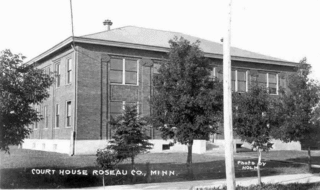
Roseau County is a county in the northwestern part of the U.S. state of Minnesota, along the Canada–US border. As of the 2020 census, the population was 15,331. Its county seat is Roseau. Roseau County borders the Canadian province of Manitoba.

<span class="mw-page-title-main">Rice County, Minnesota</span> County in Minnesota, United States

Rice County is a county located in the south central portion of the U.S. state of Minnesota. As of the 2020 census, the population was 67,097. Its county seat is Faribault.

<span class="mw-page-title-main">Polk County, Minnesota</span> County in Minnesota, United States

Polk County is a county in the northwestern part of the U.S. state of Minnesota. The population was 31,192 at the 2020 census. Its county seat is Crookston, and the largest community is East Grand Forks.

<span class="mw-page-title-main">Pipestone County, Minnesota</span> County in Minnesota, United States

Pipestone County is a county in the U.S. state of Minnesota. As of the 2020 census, the population was 9,424. Its county seat is Pipestone.

<span class="mw-page-title-main">Pennington County, Minnesota</span> County in Minnesota, United States

Pennington County is a county in the northwestern part of the U.S. state of Minnesota. As of the 2020 census, the population was 13,992. Its county seat is Thief River Falls.

<span class="mw-page-title-main">Norman County, Minnesota</span> County in Minnesota, United States

Norman County is a county in the northwestern part of the U.S. state of Minnesota. As of the 2020 census, the population was 6,441. Its county seat is Ada. The county is in Minnesota's Red River Valley region.

<span class="mw-page-title-main">McLeod County, Minnesota</span> County in Minnesota, United States

McLeod County is a county in the U.S. state of Minnesota. At the 2020 census, the population was 36,771. Its county seat is Glencoe.

<span class="mw-page-title-main">Lyon County, Minnesota</span> County in Minnesota, United States

Lyon County is a county in the U.S. state of Minnesota. As of the 2020 census, the population was 25,269. Its county seat is Marshall.

<span class="mw-page-title-main">Lincoln County, Minnesota</span> County in Minnesota, United States

Lincoln County is a county in the U.S. state of Minnesota. As of the 2020 census, the population was 5,640. Its county seat is Ivanhoe.

<span class="mw-page-title-main">Lac qui Parle County, Minnesota</span> County in Minnesota, United States

Lac qui Parle County is a county in the southwestern part of the U.S. state of Minnesota. As of the 2020 census, the population was 6,719. Its county seat is Madison. The largest city in the county is Dawson.

<span class="mw-page-title-main">Kittson County, Minnesota</span> County in Minnesota, United States

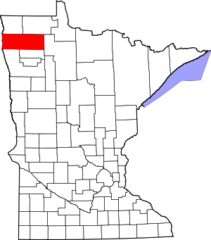
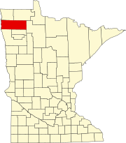
Kittson County is a county in the northwestern corner of the U.S. state of Minnesota along the Canada–US border, south of the Canadian province of Manitoba. As of the 2020 census, the population was 4,207. Its county seat is Hallock.

<span class="mw-page-title-main">Goodhue County, Minnesota</span> County in Minnesota, United States

Goodhue County is a county in the U.S. state of Minnesota. As of the 2020 census, the population was 47,582. Its county seat is Red Wing. Nearly all of Prairie Island Indian Community is within the county.

<span class="mw-page-title-main">Cass County, Minnesota</span> County in Minnesota, United States

Cass County is a county in the central part of the U.S. state of Minnesota. As of the 2020 census, the population was 30,066. Its county seat is Walker. The county was formed in 1851, and was organized in 1897.

<span class="mw-page-title-main">Blue Earth County, Minnesota</span> County in Minnesota, United States

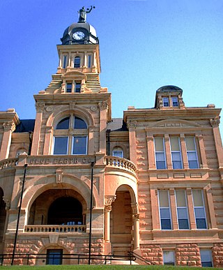
Blue Earth County is a county in the State of Minnesota. As of the 2020 census, the population was 69,112. Its county seat is Mankato. The county is named for the Blue Earth River and for the deposits of blue-green clay once evident along the banks of the Blue Earth River. Blue Earth County is part of the Mankato-North Mankato metropolitan area.

References

  1. "Minnesota Place Names". Minnesota Historical Society. Archived from the original on June 20, 2012. Retrieved March 18, 2014.
  2. 1 2 "State & County QuickFacts". United States Census Bureau. Retrieved April 10, 2023.
  3. "Find a County". National Association of Counties. Retrieved June 7, 2011.
  4. Upham, Warren (1920). Minnesota Geographic Names: Their Origin and Historic Significance. Minnesota Historical Society. pp.  326, 331.
  5. 1 2 3 4 Marshall County MN Google Maps (accessed April 18, 2019)
  6. ""Find an Altitude/Marshall County MN" Google Maps (accessed April 18, 2019)". Archived from the original on May 21, 2019. Retrieved April 19, 2019.
  7. "2010 Census Gazetteer Files". United States Census Bureau. August 22, 2012. Archived from the original on September 21, 2013. Retrieved October 21, 2014.
  8. Nelson, Steven (2011). Savanna Soils of Minnesota. Minnesota: Self. pp. 57–60. ISBN   978-0-615-50320-2.
  9. "Annual Estimates of the Resident Population for Counties: April 1, 2020 to July 1, 2023" . Retrieved March 18, 2024.
  10. "U.S. Decennial Census". United States Census Bureau. Retrieved October 21, 2014.
  11. "Historical Census Browser". University of Virginia Library. Retrieved October 21, 2014.
  12. "Population of Counties by Decennial Census: 1900 to 1990". United States Census Bureau. Retrieved October 21, 2014.
  13. "Census 2000 PHC-T-4. Ranking Tables for Counties: 1990 and 2000" (PDF). United States Census Bureau. Archived (PDF) from the original on March 27, 2010. Retrieved October 21, 2014.
  14. "P2 HISPANIC OR LATINO, AND NOT HISPANIC OR LATINO BY RACE – 2020: DEC Redistricting Data (PL 94-171) – Marshall County, Minnesota".
  15. Leip, David. "Atlas of US Presidential Elections". uselectionatlas.org. Retrieved October 9, 2018.
  16. "COMMISSIONERS". www.co.marshall.mn.us. Retrieved April 25, 2023.
  17. "MN State Senate". www.senate.mn. Retrieved June 25, 2020.
  18. "U.S. Senator Amy Klobuchar". www.klobuchar.senate.gov. Retrieved June 24, 2020.
  19. "Home". Senator Tina Smith. Retrieved June 24, 2020.

48°21′N96°23′W / 48.35°N 96.38°W / 48.35; -96.38