Farm Island Township is a township in Aitkin County, Minnesota, United States. The population was 1,099 as of the 2010 census.
Lake Crystal is a city in Blue Earth County, Minnesota, United States, established in 1869. The population was 2,539 at the 2020 census. It is part of the Mankato-North Mankato Metropolitan Statistical Area.
Shelby Township is a township in Blue Earth County, Minnesota, United States. The population was 294 as of the 2000 census.

Dilworth is a city in Clay County, Minnesota, United States. The population was 4,612 at the time of the 2020 census. Dilworth is one of the core cities of the Fargo–Moorhead metro area; it is on the eastern border of Moorhead. Dilworth is home to the historic Star Lite Motel and the Dilworth Rail Yard, one of the BNSF Railway's largest and busiest facilities in Minnesota.

Norcross is a city in Grant County, Minnesota, United States, along the Mustinka River. The population was 70 at the 2010 census.

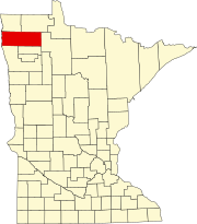
Warren is a city in and the county seat of Marshall County, Minnesota, United States. The population was 1,605 at the 2020 census.

Litchfield is a city in and the county seat of Meeker County, Minnesota, United States. The population was 6,624 at the 2020 census.
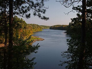
Crow Wing State Park is a state park of Minnesota, United States, at the confluence of the Mississippi and Crow Wing Rivers. The park interprets the site of Old Crow Wing, one of the most populous towns in Minnesota in the 1850s and 1860s. The entire park was added to the National Register of Historic Places in 1970. A section of the Red River Trails that passed through Old Crow Wing is also separately listed on the National Register.
San Francisco is an abandoned townsite in San Francisco Township in Carver County, Minnesota, United States.
Celina was an unincorporated community in Saint Louis County, Minnesota, United States. The early 20th century community was once home to a Lutheran church, post office, and general stores. The village was located near Greaney and Bear River, Minnesota.
Muskoda is a ghost town in section 7 of Hawley Township in Clay County, Minnesota, United States.

Mallard is an abandoned townsite in sections 5 and 8 of Itasca Township in Clearwater County, Minnesota, United States. The nearest community is Alida, Minnesota, to the north.
Vicksburg is an abandoned townsite in section 30 of Flora Township in Renville County, Minnesota, United States. The nearest community is the small city of Delhi, south across the Minnesota River in Redwood County.

Splitrock is an abandoned townsite in Beaver Bay Township, Lake County, Minnesota, United States; located at the mouth of the Split Rock River.
Reading is an unincorporated community in Nobles County, Minnesota, United States.
Wannaska is an unincorporated community in Roseau County, Minnesota, United States.

Minnesota Junction is an unincorporated community located, in the town of Oak Grove, in Dodge County, Wisconsin, United States. Minnesota Junction is located on Wisconsin Highway 26. It is located at latitude 43.452 and longitude -88.697 at 925 feet above mean sea level.

Cammal is an unincorporated community in McHenry Township, Lycoming County, in the U.S. state of Pennsylvania. It lies along Pine Creek in the Pine Creek Gorge, upstream of Waterville, along Pennsylvania Route 414. Mill Run, which flows through the nearby Tiadaghton State Forest, enters Pine Creek at Cammal. The Pine Creek Rail Trail passes through Cammal.

Wilno is an unincorporated community located in Royal Township, Lincoln County, Minnesota, United States.

The historic communities of Alachua County were populated places and/or places with a post office that were established in the 19th century or early 20th century in what is now Alachua County, Florida, but which were abandoned, annexed into an incorporated municipality, or had a much reduced population by the later part of the 20th century.