Stephen, Minnesota

Last updated
Stephen
Motto: 
"Settle For Success"
Marshall County Minnesota Incorporated and Unincorporated areas Stephen Highlighted.svg
Location of Stephen, Minnesota
Coordinates: 48°27′2″N96°52′31″W / 48.45056°N 96.87528°W / 48.45056; -96.87528
CountryUnited States
State Minnesota
County Marshall
Area
[1]
  Total0.79 sq mi (2.04 km2)
  Land0.79 sq mi (2.04 km2)
  Water0.00 sq mi (0.00 km2)
Elevation
830 ft (253 m)
Population
 (2020) [2]
  Total592
  Estimate 
(2021) [3]
583
  Density752.22/sq mi (290.29/km2)
Time zone UTC-6 (CST)
  Summer (DST) UTC-5 (CDT)
ZIP code
56757
Area code 218
FIPS code 27-62698
GNIS feature ID0652619 [4]
Website stephenmn.com

Stephen is a city in Marshall County, Minnesota, United States. The population was 592 at the 2020 census. [2]

Contents

History

A post office called Stephen has been in operation since 1883. [5] The city was named for George Stephen, a railroad official. [6]

Geography

According to the United States Census Bureau, the city has a total area of 0.81 square miles (2.10 km2), all land. [7]

Demographics

Historical population
CensusPop.Note
1890 265
1900 51393.6%
1910 61820.5%
1920 581−6.0%
1930 474−18.4%
1940 67342.0%
1950 87730.3%
1960 858−2.2%
1970 9045.4%
1980 898−0.7%
1990 707−21.3%
2000 7080.1%
2010 658−7.1%
2020 592−10.0%
2021 (est.)583 [3] −1.5%
U.S. Decennial Census [8]
2020 Census [2]

2010 census

As of the census of 2010, there were 658 people, 304 households, and 174 families living in the city. The population density was 812.3 inhabitants per square mile (313.6/km2). There were 346 housing units at an average density of 427.2 per square mile (164.9/km2). The racial makeup of the city was 97.9% White, 0.2% Native American, 1.7% from other races, and 0.3% from two or more races. Hispanic or Latino of any race were 10.0% of the population.

There were 304 households, of which 21.4% had children under the age of 18 living with them, 48.4% were married couples living together, 5.6% had a female householder with no husband present, 3.3% had a male householder with no wife present, and 42.8% were non-families. 40.1% of all households were made up of individuals, and 19.7% had someone living alone who was 65 years of age or older. The average household size was 2.16 and the average family size was 2.93.

The median age in the city was 46.8 years. 20.8% of residents were under the age of 18; 4.9% were between the ages of 18 and 24; 21.4% were from 25 to 44; 29.7% were from 45 to 64; and 23.1% were 65 years of age or older. The gender makeup of the city was 49.4% male and 50.6% female.

2000 census

As of the census of 2000, there were 708 people, 292 households, and 188 families living in the city. The population density was 865.0 inhabitants per square mile (334.0/km2). There were 331 housing units at an average density of 404.4 per square mile (156.1/km2). The racial makeup of the city was 93.36% White, 0.71% Native American, 0.14% Asian, 4.66% from other races, and 1.13% from two or more races. Hispanic or Latino of any race were 8.19% of the population.

There were 292 households, out of which 28.4% had children under the age of 18 living with them, 56.5% were married couples living together, 4.5% had a female householder with no husband present, and 35.3% were non-families. 33.2% of all households were made up of individuals, and 22.6% had someone living alone who was 65 years of age or older. The average household size was 2.42 and the average family size was 3.13.

In the city, the population was spread out, with 26.0% under the age of 18, 7.1% from 18 to 24, 20.6% from 25 to 44, 23.7% from 45 to 64, and 22.6% who were 65 years of age or older. The median age was 43 years. For every 100 females, there were 99.4 males. For every 100 females age 18 and over, there were 95.5 males.

The median income for a household in the city was $33,207, and the median income for a family was $42,969. Males had a median income of $31,103 versus $21,667 for females. The per capita income for the city was $17,152. About 3.3% of families and 6.2% of the population were below the poverty line, including 2.4% of those under age 18 and 12.7% of those age 65 or over.

Related Research Articles

<span class="mw-page-title-main">Underwood-Petersville, Alabama</span> Census-designated place in Alabama, United States

Underwood-Petersville is a census-designated place (CDP) in Lauderdale County, Alabama United States. It is part of the Florence - Muscle Shoals Metropolitan Statistical Area known as "The Shoals". As of the 2010 census, the population of the CDP is 3,247.

<span class="mw-page-title-main">Bucks Lake, California</span> Census-designated place in California, United States

Bucks Lake is a census-designated place (CDP) in Plumas County, California, United States. Bucks Lake is located on the south shore of the lake of the same name, 13 miles (20.9 km) west-southwest of Quincy. The population was 22 at the 2020 census, up from 10 at the 2010 census.

<span class="mw-page-title-main">Axtell, Kansas</span> City in Marshall County, Kansas

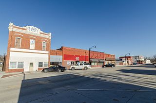
Axtell is a city in Marshall County, Kansas, United States. As of the 2020 census, the population of the city was 399.

<span class="mw-page-title-main">Edgerton, Minnesota</span> City in Minnesota, United States

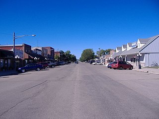
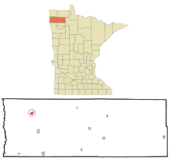
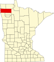
Edgerton is a city in Pipestone County, Minnesota, United States, located along the Rock River. The population was 1,189 at the 2010 census.

<span class="mw-page-title-main">Fort Calhoun, Nebraska</span> City in Nebraska, United States

Fort Calhoun is a city in Washington County, Nebraska, United States. The population was 908 at the 2010 census. The city includes Fort Atkinson, the first fort built west of the Missouri River.

<span class="mw-page-title-main">Blue Hill, Nebraska</span> City in Nebraska, United States

Blue Hill is a town in Webster County, Nebraska, United States. The population was 936 at the 2010 census.

<span class="mw-page-title-main">Myers Corner, New York</span> Census-designated place in New York, United States

Myers Corner is a hamlet and census-designated place (CDP) in the town of Wappinger, Dutchess County, New York, United States. The population was 6,790 at the 2010 census. It is part of the Poughkeepsie–Newburgh–Middletown, NY Metropolitan Statistical Area as well as the larger New York–Newark–Bridgeport, NY-NJ-CT-PA Combined Statistical Area.

New Eucha is a census-designated place (CDP) in Delaware County, Oklahoma, United States. The population was 405 at the 2010 census, up from the figure of 300 recorded in 2000.

<span class="mw-page-title-main">Tryon, Oklahoma</span> Town in Oklahoma, United States

Tryon is a town in Lincoln County, Oklahoma, United States. The population was 491 at the 2010 census. The community is named after early land owner Fred S. Tryon.

<span class="mw-page-title-main">Grayson, Oklahoma</span> Town in Oklahoma, United States

Grayson is a town in Okmulgee County, Oklahoma, United States. The population was 159 at the 2010 census, an increase of 18.7 percent from the figure of 134 recorded in 2000.

<span class="mw-page-title-main">Wayne Township, Dauphin County, Pennsylvania</span> Township in Pennsylvania, United States

Wayne Township is a township in Dauphin County, Pennsylvania, United States. The population was 1,264 at the 2020 census.

<span class="mw-page-title-main">Burrell Township, Indiana County, Pennsylvania</span> Township in Pennsylvania, United States

Burrell Township is a township in Indiana County, Pennsylvania, United States. Burrell Township was formed from Black Lick Township in 1853, named after Judge Burrell. The population was 3,525 at the 2020 census, a decline from the figure of 4,393 tabulated in 2010. The township includes the communities of Bell's Mills, Black Lick, Campbells Mill, Fairfield Heights, Josephine, Marshall Heights, Oake's Point, Palmertown, Smith, and Strangford.

<span class="mw-page-title-main">West Wheatfield Township, Indiana County, Pennsylvania</span> Township in Pennsylvania, United States

West Wheatfield Township is a township in Indiana County, Pennsylvania, United States. The population was 2,164 at the 2020 census. The township includes the communities of Centerville, Climax, Clyde, Conpitt Junction, Germany, Heshbon, India, and Robinson.

<span class="mw-page-title-main">Spruce Hill Township, Juniata County, Pennsylvania</span> Township in Pennsylvania, United States

Spruce Hill Township is a township in Juniata County, Pennsylvania, United States. The population was 791 at the 2020 census, a decline from the figure of 834 tabulated in 2010.

<span class="mw-page-title-main">French Creek Township, Mercer County, Pennsylvania</span> Township in Pennsylvania, United States

French Creek Township is a township in Mercer County, Pennsylvania, United States. The population was 710 at the 2020 census, a decrease from the figure of 771 in 2010.

<span class="mw-page-title-main">Greene Township, Mercer County, Pennsylvania</span> Township in Pennsylvania, United States

Greene Township is a township in Mercer County, Pennsylvania, United States. At the 2020 census, the township population was 1,051, down from 1,091 in 2010.

<span class="mw-page-title-main">Salem Township, Mercer County, Pennsylvania</span> Township in Pennsylvania, United States

Salem Township is a township in Mercer County, Pennsylvania, United States. The population was 752 at the 2020 census, down from 754 in 2010.

<span class="mw-page-title-main">Sandy Creek Township, Mercer County, Pennsylvania</span> Township in Pennsylvania, United States

Sandy Creek Township is a township in Mercer County, Pennsylvania, United States. The population was 800 at the 2020 census, up from 795 in 2010.

<span class="mw-page-title-main">Saville Township, Perry County, Pennsylvania</span> Township in Pennsylvania, United States

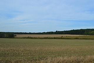
Saville Township is a second-class township in a mountainous part of Perry County, Pennsylvania, United States. As of the 2020 census, the township had a total population of 2,597. It was founded in 1817, dividing from Tyrone Township while the area was still part of Cumberland County. It is served by two major roads, PA 74, locally called Veterans Way, and PA 17, called the Tuscorara Path. The county office is at 3954 Veterans Way, in Elliottsburg, in the far southern part of the township. The area is overwhelmingly agricultural, with small population centers in Ickesburg and the hamlet of Saville.

<span class="mw-page-title-main">Shelby, Iowa</span> City in Iowa, United States

Shelby is a city in Pottawattamie and Shelby counties in the U.S. state of Iowa. The population was 727 at the time of the 2020 census.

References

  1. "2020 U.S. Gazetteer Files". United States Census Bureau. Retrieved July 24, 2022.
  2. 1 2 3 "Explore Census Data". United States Census Bureau . Retrieved May 19, 2022.
  3. 1 2 "City and Town Population Totals: 2020-2021". United States Census Bureau. June 25, 2022. Retrieved June 25, 2022.
  4. "US Board on Geographic Names". United States Geological Survey. October 25, 2007. Retrieved January 31, 2008.
  5. "Marshall County". Jim Forte Postal History. Retrieved July 13, 2015.
  6. Upham, Warren (1920). Minnesota Geographic Names: Their Origin and Historic Significance. Minnesota Historical Society. p.  330.
  7. "US Gazetteer files 2010". United States Census Bureau. Archived from the original on January 12, 2012. Retrieved November 13, 2012.
  8. United States Census Bureau. "Census of Population and Housing" . Retrieved June 9, 2014.

Coordinates: 48°27′00″N96°52′21″W / 48.45000°N 96.87250°W / 48.45000; -96.87250