
Pope County is a county in the U.S. state of Minnesota. As of the 2010 United States Census, the population was 10,995. Its county seat is Glenwood. The county was formed in 1862 and organized in 1866.

Chippewa Falls is a city located on the Chippewa River in Chippewa County in the U.S. state of Wisconsin. The most recent census from 2010 shows that the population is 13,661. Incorporated as a city in 1869, it is the county seat of Chippewa County.

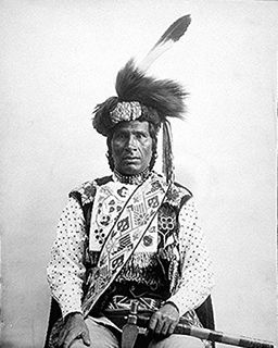
The Ojibwe, Ojibwa, Chippewa, or Saulteaux are an Anishinaabe people of Canada and the United States. They are one of the most numerous indigenous peoples north of the Rio Grande. In Canada, they are the second-largest First Nations population, surpassed only by the Cree. In the United States, they have the fifth-largest population among Native American peoples, surpassed in number only by the Navajo, Cherokee, Choctaw and Sioux.
Winston Churchill (1874–1965) was a British statesman who led the United Kingdom during the Second World War.
Chippewa is an alternate spelling of the Ojibwe tribe of North America.
The White Earth Indian Reservation is the home to the White Earth Band, located in northwestern Minnesota. It is the largest Indian reservation in that state by land area. The reservation includes all of Mahnomen County, plus parts of Becker and Clearwater counties in the northwest part of the state, along the Wild Rice and White Earth rivers. It is about 225 miles (362 km) from Minneapolis-St. Paul and roughly 65 miles (105 km) from Fargo-Moorhead.
Bois Forte Indian Reservation is an Indian reservation formed for the Bois Forte Band of Chippewa.
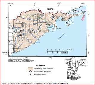
The Grand Portage Indian Reservation is located in Cook County near the tip of Minnesota's Arrowhead Region in the extreme northeast part of the state. The community was considered part of the Lake Superior Band of Chippewa, but is not a party to the treaties that group signed. The reservation was established as part of an 1854 treaty, and the land area is 74.396 sq mi.

The Leech Lake Indian Reservation is an Indian reservation located in the north-central Minnesota counties of Cass, Itasca, Beltrami, and Hubbard. The reservation forms the land base for the federally recognized Leech Lake Band of Ojibwe, one of six bands comprising the Minnesota Chippewa Tribe, organized in 1934. The Leech Lake Reservation has the highest population of any reservation in Minnesota, with a resident population of 10,660 indicated by the 2010 United States census.
Mille Lacs Indian Reservation is the popular name for the land-base for the Mille Lacs Band of Ojibwe in Central Minnesota, about 100 miles (160 km) north of Minneapolis-St. Paul. The contemporary Mille Lacs Band reservation has significant land holdings in Mille Lacs, Pine, Aitkin and Crow Wing counties, as well as other land holdings in Kanabec, Morrison, and Otter Tail Counties. Mille Lacs Indian Reservation is also the name of a formal Indian reservation established in 1855. It is one of the two formal reservations on which the contemporary Mille Lacs Band retains land holdings. The contemporary Mille Lacs band includes several aboriginal Ojibwe bands and villages, whose members reside in communities throughout central Minnesota.

The Chippewa River is a 153-mile-long (246 km) tributary of the Minnesota River in western and southwestern Minnesota in the United States. Via the Minnesota River, it is part of the watershed of the Mississippi River.

Sandy Lake is an unincorporated community Native American village located in Turner Township, Aitkin County, Minnesota, United States. Its name in the Ojibwe language is Gaa-mitaawangaagamaag, meaning "Place of the Sandy-shored Lake". The village is administrative center for the Sandy Lake Band of Mississippi Chippewa, though the administration of the Mille Lacs Indian Reservation, District II, is located in the nearby East Lake.
Max is an unincorporated community in Max Township, Itasca County, Minnesota, United States; located within the Chippewa National Forest and the Leech Lake Indian Reservation.
This is a list of the National Register of Historic Places listings in Chippewa County, Minnesota. It is intended to be a complete list of the properties and districts on the National Register of Historic Places in Chippewa County, Minnesota, United States. The locations of National Register properties and districts for which the latitude and longitude coordinates are included below, may be seen in an online map.
Montevideo–Chippewa County Airport is an airport in Montevideo, Minnesota, United States.
Bergville is an unincorporated community in Ardenhurst Township, Itasca County, Minnesota, United States; located within the Chippewa National Forest.
Wegdahl is an unincorporated community in Chippewa County, in the U.S. state of Minnesota.

Terrace is an unincorporated community in Chippewa Falls Township, Pope County, Minnesota, United States. The community was settled in the 1870s around the Terrace Mill. In 1982 a historic district of early buildings and structures was listed on the National Register of Historic Places as the Terrace Historic District for having local significance under the themes of exploration/settlement and industry. It was nominated as a well-preserved example of the small communities that grew up around Minnesota's rural mills in the latter 19th century.


