Clara City, Minnesota

Last updated

Clara City
Motto: 
"Crossroads of the Prairie" [1]
Chippewa County Minnesota Incorporated and Unincorporated areas Clara City Highlighted.svg
Location of Clara City, Minnesota
Coordinates: 44°57′28″N95°22′02″W / 44.95778°N 95.36722°W / 44.95778; -95.36722
Country United States
State Minnesota
County Chippewa
Area
[2]
  Total1.88 sq mi (4.87 km2)
  Land1.88 sq mi (4.87 km2)
  Water0.00 sq mi (0.00 km2)
Elevation
[3]
1,063 ft (324 m)
Population
 (2020)
  Total1,423
  Density756.91/sq mi (292.27/km2)
Time zone UTC-6 (Central (CST))
  Summer (DST) UTC-5 (CDT)
ZIP code
56222
Area code 320
FIPS code 27-11548 [4]
GNIS feature ID663803 [3]
Website www.claracity.org

Clara City is a city in Chippewa County, Minnesota, United States. The population was 1,423 at the 2020 census. [5]

Contents

History

Clara City developed as a railroad station for the Willmar & Sioux Falls Railway. Clara City was founded in 1887. [6] It is named after Clara Koch, the wife of one of the town founders. [7] The city was incorporated in September 1891. [1]

Geography

According to the United States Census Bureau, the city has a total area of 1.74 square miles (4.51 km2), all land. [8]

Minnesota State Highways 7 and 23 are two of the main routes in the city.

Churches

Clara City has five churches. Bethany Reformed Church (RCA), Immanuel Lutheran Church (ELCA), St. Clara's Catholic Church, and Faith Lutheran Church are in town, and Bunde Christian Reformed Church is three miles outside of town on Highway 7.

Demographics

Historical population
CensusPop.Note
1900 465
1910 58726.2%
1920 75027.8%
1930 730−2.7%
1940 84515.8%
1950 1,10630.9%
1960 1,35822.8%
1970 1,4919.8%
1980 1,5745.6%
1990 1,307−17.0%
2000 1,3936.6%
2010 1,360−2.4%
2020 1,4234.6%
U.S. Decennial Census

2010 census

As of the census [9] of 2010, there were 1,360 people, 584 households, and 360 families living in the city. The population density was 781.6 inhabitants per square mile (301.8/km2). There were 625 housing units at an average density of 359.2 per square mile (138.7/km2). The racial makeup of the city was 96.9% White, 0.5% African American, 0.1% Native American, 0.1% Asian, 1.4% from other races, and 1.0% from two or more races. Hispanic or Latino of any race were 3.8% of the population.

There were 584 households, of which 26.5% had children under the age of 18 living with them, 48.8% were married couples living together, 9.1% had a female householder with no husband present, 3.8% had a male householder with no wife present, and 38.4% were non-families. 35.3% of all households were made up of individuals, and 22.3% had someone living alone who was 65 years of age or older. The average household size was 2.21 and the average family size was 2.83.

The median age in the city was 44.8 years. 22.9% of residents were under the age of 18; 6.4% were between the ages of 18 and 24; 20.8% were from 25 to 44; 23.1% were from 45 to 64; and 26.8% were 65 years of age or older. The gender makeup of the city was 47.6% male and 52.4% female.

2000 census

As of the census [4] of 2000, there were 1,393 people, 591 households, and 372 families living in the city. The population density was 729.0 inhabitants per square mile (281.5/km2). There were 629 housing units at an average density of 329.2 per square mile (127.1/km2). The racial makeup of the city was 98.13% White, 0.14% African American, 0.07% Native American, 0.14% Asian, 1.29% from other races, and 0.22% from two or more races. Hispanic or Latino of any race were 2.15% of the population.

There were 591 households, out of which 25.7% had children under the age of 18 living with them, 55.3% were married couples living together, 5.4% had a female householder with no husband present, and 36.9% were non-families. 34.0% of all households were made up of individuals, and 23.2% had someone living alone who was 65 years of age or older. The average household size was 2.19 and the average family size was 2.81.

In the city, the population was spread out, with 20.2% under the age of 18, 5.4% from 18 to 24, 20.7% from 25 to 44, 22.0% from 45 to 64, and 31.7% who were 65 years of age or older. The median age was 48 years. For every 100 females, there were 90.3 males. For every 100 females age 18 and over, there were 81.4 males.

The median income for a household in the city was $34,306, and the median income for a family was $45,189. Males had a median income of $28,839 versus $23,304 for females. The per capita income for the city was $17,639. About 3.0% of families and 7.3% of the population were below the poverty line, including 4.6% of those under age 18 and 12.9% of those age 2 or over.

Related Research Articles

<span class="mw-page-title-main">Hamburg, Minnesota</span> City in Minnesota, United States

Hamburg is a city in Carver County, Minnesota, United States. The population was 513 at the 2010 census.

<span class="mw-page-title-main">Lake Shore, Minnesota</span> City in Minnesota, United States

Lake Shore is a city in Cass County, Minnesota, United States. The population was 1,056 at the 2020 census. It is part of the Brainerd Micropolitan Statistical Area.

<span class="mw-page-title-main">Hitterdal, Minnesota</span> City in Minnesota, United States

Hitterdal is a city in Clay County, Minnesota, United States. The population was 199 at the 2020 census.

<span class="mw-page-title-main">Isanti, Minnesota</span> City in the United States

Isanti is a city in Isanti County, Minnesota, United States. The population was 6,804 at the 2020 census. The name Isanti is composed of two Dakota words: isan ("knife") and ati ("camp"), and refers to the Santee Dakota people.

<span class="mw-page-title-main">La Prairie, Minnesota</span> City in Minnesota, United States

La Prairie is a city in Itasca County, Minnesota, United States. The population was 653 at the 2020 census.

<span class="mw-page-title-main">Raymond, Minnesota</span> City in Minnesota, United States

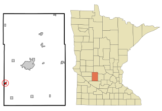
Raymond is a city in southwest Kandiyohi County, Minnesota, United States. The population was 764 at the 2010 census.

<span class="mw-page-title-main">Clitherall, Minnesota</span> City in Minnesota, United States

Clitherall is a city in Otter Tail County, Minnesota, United States. The population was 62 at the 2020 census.

<span class="mw-page-title-main">Deer Creek, Minnesota</span> City in Minnesota, United States

Deer Creek is a city in Otter Tail County, Minnesota, United States. The population was 330 at the 2020 census.

<span class="mw-page-title-main">Henning, Minnesota</span> City in Minnesota, United States

Henning is a city in Otter Tail County, Minnesota, United States. The population was 854 at the 2020 census.

<span class="mw-page-title-main">Climax, Minnesota</span> City in Minnesota, United States

Climax is a city in Polk County, Minnesota, United States. It is part of the Grand Forks, ND-MN Metropolitan Statistical Area. The population was 243 at the 2020 census.

<span class="mw-page-title-main">Maplewood, Minnesota</span> City in Minnesota, United States

Maplewood is a city in Ramsey County, Minnesota, United States. The population was 42,088 at the 2020 census. Maplewood is ten minutes' drive from downtown Saint Paul. It stretches along the northern and eastern borders of Saint Paul.

<span class="mw-page-title-main">Hector, Minnesota</span> City in Minnesota, United States

Hector is a city in Renville County, Minnesota, United States. The population was 1,012 at the 2020 census.

<span class="mw-page-title-main">Hoyt Lakes, Minnesota</span> City in Minnesota, United States

Hoyt Lakes is a city in Saint Louis County, Minnesota. The population was 2,020 at the time of the 2020 census.

<span class="mw-page-title-main">Hancock, Minnesota</span> City in Minnesota, United States

Hancock is a city in Stevens County, Minnesota, United States. The population was 863 at the 2020 census.

<span class="mw-page-title-main">Dellwood, Minnesota</span> City in Minnesota, United States

Dellwood is a city in Washington County, Minnesota, United States and a suburb of St. Paul. The population was 1,063 at the 2010 census.

<span class="mw-page-title-main">Grant, Minnesota</span> City in Minnesota, United States

Grant is a city in Washington County, Minnesota, and a suburb of St. Paul. The population was 4,096 at the time of the 2010 census.

<span class="mw-page-title-main">Lewiston, Minnesota</span> City in Minnesota, United States

Lewiston is a city in Winona County, Minnesota, United States. The population was 1,620 at the 2010 census.

<span class="mw-page-title-main">Rollingstone, Minnesota</span> City in Minnesota, United States

Rollingstone is a city in Winona County, Minnesota, United States. The population was 678 at the 2020 census.

<span class="mw-page-title-main">Center City, Minnesota</span> City in Minnesota, United States

Center City is a city and the county seat of Chisago County, Minnesota, United States. The population was 628 at the 2010 census.

<span class="mw-page-title-main">Minnesota Lake, Minnesota</span> City in Minnesota, United States

Minnesota Lake is a city in Blue Earth and Faribault counties in the State of Minnesota. The population was 661 at the 2020 census. The bulk of the city is in Faribault County; a small part extends into Blue Earth County.

References

  1. 1 2 "City of Clara City Minnesota". City of Clara City Minnesota. Retrieved October 4, 2012.
  2. "2020 U.S. Gazetteer Files". United States Census Bureau. Retrieved July 24, 2022.
  3. 1 2 U.S. Geological Survey Geographic Names Information System: Clara City, Minnesota
  4. 1 2 "U.S. Census website". United States Census Bureau . Retrieved January 31, 2008.
  5. "Explore Census Data". data.census.gov. Retrieved June 7, 2024.
  6. Upham, Warren (1920). Minnesota Geographic Names: Their Origin and Historic Significance. Minnesota Historical Society. p.  103.
  7. "Profile for Clara City, Minnesota, MN". ePodunk. Archived from the original on May 14, 2019. Retrieved October 4, 2012.
  8. "US Gazetteer files 2010". United States Census Bureau. Archived from the original on January 25, 2012. Retrieved November 13, 2012.
  9. "U.S. Census website". United States Census Bureau . Retrieved November 13, 2012.