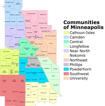
Minneapolis is officially defined by its city council as divided into 83 neighborhoods. The neighborhoods are historically grouped into 11 communities. Informally, there are city areas with colloquial labels. Residents may also group themselves by their city street suffixes: North, Northeast, South, and Southeast.
The local community defines several general areas based on the directional suffixes added to streets in the city. These city areas do not necessarily correlate with official community or neighborhood definitions.
Downtown Minneapolis refers to the street grid area aligned on a diagonal with the Mississippi River bend, as opposed to the true north-south grid orientation. The area north of downtown on the west bank of the Mississippi River is considered North Minneapolis. The part of Minneapolis on the east bank of the Mississippi River is divided by East Hennepin Avenue into Northeast and Southeast, approximately aligned with the communities of Northeast and University, respectively.
The entire area south of downtown is widely called South Minneapolis. The westerly portion surrounding the city's Chain of Lakes is loosely labeled Southwest Minneapolis, bounded on the east by I-35W and on the north by 36th St W, which extends west from Bde Maka Ska to the city limits.
Common conceptions of Minneapolis neighborhoods do not always align with official city maps. Residents on the borders of surrounding cities may sometimes say they live in a bordering community. Twin Cities residents and visitors frequently use generalized names based on geography, such as "North Minneapolis". What most people would consider North Minneapolis is a combination of the Near North and Camden communities, each of which is made up of several neighborhoods.[2] This also applies to neighborhoods, with residents living by definition in one neighborhood, but classifying themselves in another.
Neighborhood organization
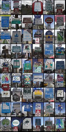
Minneapolis neighborhood markers.
The Minneapolis City Council, made up of one representative from each of the city's 13 wards, has legislative authority to define neighborhood boundaries. Community and neighborhood boundaries are not the same as the Ward boundaries, which are adjusted after each decennial census.[3][4]
Minneapolis consists of 83 neighborhoods.[5] On creating the neighborhood designation, the city grouped these neighborhoods into 11 communities, containing between 4 and 13 neighborhoods each.[6] The official neighborhoods have a variety of origins; some were formed out of the attendance areas for elementary schools, while others are the areas of coverage of neighborhood associations activists formed between 1901 and the 1980s. Most of these neighborhoods are represented by one of 69 Neighborhood Associations, some of which cover multiple neighborhoods.[7] In 2023, the organizations serving Beltrami and Northeast Park merged, taking the number down from 70.[8]
The division of the city into official neighborhoods and communities occurred as part of the Neighborhood Revitalization Program (NRP) in the early 1990s. The NRP was initially a community-based program. It divided neighborhoods into three groups based on an evaluation of problem and need areas, then allocated funds accordingly.[9] In 2012, the program lost its independent policy board and was absorbed under other city programs.[10]
The neighborhoods remain associated with the NRP[11] and are also used for statistical purposes.[12] For NRP purposes, some neighborhoods have combined forces, resulting in a total of 67 NRP neighborhood action plans.[13] As of 2024, the NRP is under the Neighborhood and Community Relations department,[14] which also oversees the city's neighborhood organizations, community engagement projects, and language services.[15]
Neighborhoods historically defined themselves around schools and commercial hubs, and many trace their identities to community organizations formed in the early 20th century. The oldest, the Prospect Park Association, formed in 1901 to oppose city plans to level Tower Hill.[16] In other neighborhoods, the current official neighborhood association was formed in the 1970s and 1980s; in Linden Hills, the organization was formed in 1972 in response to proposed changes in the park, but several social and commercial organizations in the neighborhood dated to the neighborhood's development at the turn of the 20th century.[17]
In 2020, city officials designated seven new cultural districts along major commercial corridors to promote racial equity, preserve cultural identity, and promote economic growth.[18][19] Due to their location on major roads, many of these districts straddle borders between neighborhoods.[20] The seven cultural districts are 38th Street, Cedar Avenue South, Central Avenue, East Lake Street, Franklin Avenue East, West Broadway, and Lowry Avenue North.[21]
Calhoun-Isles is in western Minneapolis. It is named after Lake Calhoun (the former name of Bde Maka Ska) and Lake of the Isles. It includes the city's Uptown area.
The Nokomis community is in south Minneapolis. It takes its name from Lake Nokomis. It includes Nokomis East, which refers to the four neighborhoods of Keewaydin, Minnehaha, Morris Park, and Wenonah that are represented by one neighborhood organization.
The Northeast Community sits east of the Mississippi River and north of a combination of streets, highways, and rail lines running from 3rd Avenue Northeast on the southwest to I-35W on the southeast.
Phillips is a south Minneapolis community adjacent to downtown Minneapolis. It is named after the 19th-century abolitionist Wendell Phillips.[22] The Little Earth residential area, which has been the center of the American Indian Movement, is within the community.[23]
Powderhorn is a south Minneapolis community, named for the eponymous park and lake in its center. George Floyd Square at East 38th Street and Chicago is central border for the Bancroft, Bryant, Central, and Powderhorn Park neighborhoods.
The University community is named for the University of Minnesota. It sits on the Mississippi River's east bank and includes the parts of the West Bank surrounding the University of Minnesota and Augsburg University campuses.
Districts and other areas
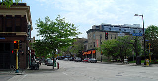
Uptown is probably the best-known business district in Minneapolis besides downtown. It centers at the intersection of West Lake Street and Hennepin Avenue, but is not officially recognized as it includes parts of four neighborhoods: South Uptown, East Bde Maka Ska, East Isles, and Lowry Hill East. The Uptown Business Association focuses on the area within a few blocks of Lake and Hennepin,[24] but the "Uptown" identity can stretch as far north as Franklin Avenue and as far east as Lyndale Avenue, where it merges into Lyn-Lake.
Eat Street is the newest of Minneapolis's commercial districts, named in the late 1990s by the Whittier Alliance to promote the international variety of restaurants along Nicollet Avenue South between Grant St. and 29th St.[25] Nicollet was historically a central commercial district in the Whittier neighborhood, but the end of the streetcar system and the construction of a K-Mart at the intersection of Nicollet and Lake Street disconnected the area in the 1970s.[26] The named district was an effort to give the neighborhood a fresh identity.
The Old St. Anthony district, also called Northeast or the Riverfront District,[27] straddles the neighborhoods of Marcy-Holmes and Nicollet Island/East Bank. It was the downtown for the city of St. Anthony before it joined Minneapolis in 1872.[28]
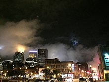
Minneapolis skyline as viewed from the Warehouse District at night, 2017.
The Warehouse District was a 19th- and early 20th-century rail and truck shipping center for the region. In the 1970s and 1980s it became an artists' quarter, and then a nightlife and entertainment district, which the southern portion (between I-394 and Hennepin Ave) remains. The district is largely in the North Loop neighborhood, but the heart of the entertainment district is in Downtown West. The City designated some of this area the Minneapolis Warehouse Historic District in 1978,[32] with portions spanning from 1st Avenue North to 10th Avenue North and from the Mississippi River to 6th Street North.[33] It was recognized by the National Register of Historic Places in 1989.[32]
Homewood is a historically significant area in Willard-Hay, bounded by Plymouth Avenue to the north, Penn Avenue to the east, Oak Park Avenue to the south, and Xerxes Avenue to the west. This area was central to the North Side Jewish community beginning in the early 1910s.[34] It was designated by the city as the Homewood Historic District on February 28, 2017,[35] due to its rich Jewish history. This designation sparked some controversy among Homewood residents.[36][37]
George Floyd Square, officially George Perry Floyd Square,[20][38] is centered on the intersection of 38th Street and Chicago Avenue, the site of the murder of George Floyd. It lies between the neighborhoods of Bancroft, Bryant, Central, and Powderhorn Park.[39][40] The area sits along the 38th street cultural district and features memorials, nonprofits, and businesses, acting as both a memorial space and a location for community organizing.[41][42]
As the Mississippi riverfront downtown has been redeveloped since the 1980s, there have been several attempts to rebrand it. The "Mississippi Mile" spanned both sides of the river from Plymouth Avenue to Portland Avenue,[43] but never really caught on locally. "Saint Anthony Main", the name of a commercial development on Main Street Southeast, can refer to the section of the East Bank around it.[44][45] More recently, people have come to call the West Bank between 3rd Avenue and the University "The Mill District",[46] though the historic locations of mills were on both sides of the river.
Some neighborhoods enjoy nicknames. Lowry Hill East is also known as "The Wedge" because of its shape.[47] Local amenities are also taken on as nicknames. "Minnehaha" refers to the area by Minnehaha Falls rather than along Minnehaha Avenue, as evidenced by the location of the Minnehaha Historic District.[48] "Tower (Hill)", along University Avenue Southeast in Prospect Park, refers to the Witch's Hat Tower.[49]
↑ Down at the Lake: A Historical Portrait of Linden Hills and the Lake Harriet District. Minneapolis: Linden Hills History Study Group, 2002. pp 57-60.
↑ Bockheim, Adrienne; Mendez, Natalia; Parrell, Rebecca; Durham, Wes (September 30, 2022). "Imagining a New Nicollet". City of Minneapolis. Retrieved 10 April 2024.
Nicollet Avenue is a major street in Minneapolis, Richfield, Bloomington, and Burnsville in the U.S. state of Minnesota. It passes through a number of locally well-known neighborhoods and districts, notably Eat Street in south Minneapolis and the traffic-restricted Nicollet Mall in downtown Minneapolis.
Whittier is a neighborhood within the Powderhorn community in the U.S. city of Minneapolis, Minnesota, bounded by Franklin Avenue on the north, Interstate 35W on the east, Lake Street on the south, and Lyndale Avenue on the west. It is known for its many diverse restaurants, coffee shops and Asian markets, especially along Nicollet Avenue. The neighborhood is home to the Minneapolis Institute of Art, the Minneapolis College of Art and Design, and the Children's Theatre Company.
The Powderhorn Park neighborhood of Minneapolis, Minnesota, United States is located approximately three miles south of downtown and is bordered by East Lake Street to the north, Cedar Avenue to the east, East 38th Street to the south, and Chicago Avenue to the west.
The Grand Rounds National Scenic Byway is a linked series of park areas in Minneapolis, Minnesota, United States, that takes a roughly circular path through the city. The Minneapolis Park and Recreation Board developed the system over many years. The corridors include roads for automobile traffic plus separate paths for pedestrians and bicycles, and extend slightly into neighboring cities. About 50 miles (80 km) of roadway and paths are in the system, and much of it was built in the 1930s as part of Civilian Conservation Corps projects.
Lake Street is a major east-west thoroughfare between 29th and 31st streets in Minneapolis, Minnesota United States. From its western most end at the city's limits, Lake Street reaches the Chain of Lakes, passing over a small channel linking Bde Maka Ska and Lake of the Isles, and at its eastern most end it reaches the Mississippi River. In May 2020, the Lake Street corridor suffered extensive damage during local unrest following the murder of George Floyd. In August of the same year, city officials designated East Lake Street as one of seven cultural districts to promote racial equity, preserve cultural identity, and promote economic growth.
Hiawatha is a neighborhood within the larger Longfellow community in Minneapolis. It is bordered by 40th Street to the north, the Mississippi River to the east, 54th Street East to the south, and Hiawatha Avenue to the west. Its neighbors are Howe to the north, the Mississippi River to the east, Minnehaha Park and the Minnehaha neighborhood to the south, and Ericsson and Standish to the west.
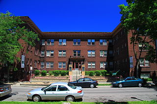
Loring Park is a neighborhood in the Central Community of Minneapolis, Minnesota. Located on the southwest corner of downtown Minneapolis, it also lends its name to Loring Park, the largest park in the neighborhood. The official boundaries of the neighborhood are Lyndale Avenue to the west, Interstate 394 to the north, 12th Street to the northeast, Highway 65 to the east, and Interstate 94 to the south. It is located in Minneapolis City Council Ward 7, represented by Katie Cashman.
Bancroft is a neighborhood within the Powderhorn community in Minneapolis, Minnesota, United States. Its boundaries are East 38th Street to the north, Chicago Avenue to the west, East 42nd Street to the south and Cedar Avenue to the east. It is entirely located within Minneapolis City Council Ward 8, represented by Andrea Jenkins.
Longfellow, also referred to as Greater Longfellow is a defined community in Minneapolis, Minnesota which includes five smaller neighborhoods inside of it: Seward, Cooper, Hiawatha, Howe and Longfellow. The community is a mix of agri-industrial properties along the old Northern Pacific Railway, expansive parkland surrounding the famous Minnehaha Falls, and smaller residential areas.
Stevens Square is the southernmost neighborhood of the Central community in Minneapolis. It is bordered on Lyndale Avenue on the west, Franklin Avenue on the south, and Interstates 94 and 35W on the north and east, respectively. The portion west of Nicollet Avenue can be referred to as Loring Heights; the portion to the East as Stevens Square.
Northeast is a defined community in the U.S. city of Minneapolis that is composed of 13 smaller neighborhoods whose street addresses end in "NE". Unofficially it also includes the neighborhoods of the University community which have "NE" addresses, and the entirety of the Old Saint Anthony business district, which sits on the dividing line of "NE" and "SE" addresses. In the wider community, this business district, which is the oldest settlement in the city, is often identified as the heart of Northeast, in part because it lies across the Mississippi River from Downtown Minneapolis. Northeast is sometimes referred to as "Nordeast", reflecting the history of northern and eastern European immigrants and their language influence.
Downtown West is an official neighborhood in Minneapolis, part of the larger Central community. It is the heart of downtown Minneapolis, containing the bulk of high-rise office buildings in the city, and is what comes to mind when most Minneapolitans think of "downtown". The neighborhood is split between Wards 3 and 7 of the Minneapolis City Council, represented by Michael Rainville and Katie Cashman, respectively.
Ericsson is a neighborhood within the Nokomis community in Minneapolis. Its boundaries are East 42nd and 43rd Streets to the north, Hiawatha Avenue to the east, Minnehaha Parkway to the south, and Cedar Avenue to the west.
Tangletown is a neighborhood in the Southwest community of Minneapolis. The neighborhood was officially known as Fuller until 1996 when it was changed to the present name, which reflects the winding streets in the neighborhood that do not conform to the regular street grid of South Minneapolis. The neighborhood boundaries are 46th Street to the north, Interstate 35W to the east, Diamond Lake Road to the south, and Lyndale Avenue South to the west. Tangletown is a part of Ward 11, currently represented by Minneapolis City Council member Emily Koski.
King Field is a neighborhood in the Southwest community in Minneapolis, Minnesota. Its boundaries are 36th Street to the north, Interstate 35W to the east, 46th Street to the south, and Lyndale Avenue to the west. King Field, within the King Field neighborhood is a park named after Martin Luther King Jr.
Saint Paul, Minnesota, consists of 17 officially defined city districts or neighborhoods.
Minneapolis is often considered one of the top biking and walking cities in the United States due to its vast network of trails and dedicated pedestrian areas. In 2020, Walk Score rated Minneapolis as 13th highest among cities over 200,000 people. Some bicycling ratings list Minneapolis at the top of all United States cities, while others list Minneapolis in the top ten. There are over 80 miles (130 km) of paved, protected pathways in Minneapolis for use as transportation and recreation. The city's Grand Rounds National Scenic Byway parkway system accounts for the vast majority of the city's shared-use paths at approximately 50 miles (80 km) of dedicated biking and walking areas. By 2008, other city, county, and park board areas accounted for approximately 30 miles (48 km) of additional trails, for a city-wide total of approximately 80 miles (130 km) of protected pathways. The network of shared biking and walking paths continued to grow into the late 2010s with the additions of the Hiawatha LRT Trail gap remediation, Min Hi Line pilot projects, and Samatar Crossing. The city also features several natural-surface hiking trails, mountain-biking paths, groomed cross-country ski trails in winter, and other pedestrian walkways.
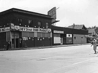
38th Street is a major east-west roadway in the U.S. city of Minneapolis and an officially designated cultural district in the Powderhorn community. The area developed into a residential zone when the Chicago Avenue street car line was extended to East 38th Street in 1880. Since the 1930s, the area has featured many Black-owned businesses, and the surrounding neighborhoods have had distinct histories from other neighborhoods in Minneapolis due to racial settlement patterns that concentrated Black residents there.
This page is based on this Wikipedia article Text is available under the CC BY-SA 4.0 license; additional terms may apply. Images, videos and audio are available under their respective licenses.