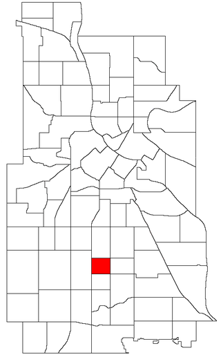
The Central neighborhood of Minneapolis, Minnesota, United States is located south of the downtown region of the city. It is bounded by Lake Street on the north, Chicago Avenue on the east, 38th Street on the south, and Interstate 35W on the west. It should not be confused with the Central community, which covers Downtown and some surrounding neighborhoods.

Minneapolis is officially defined by its city council as divided into 83 neighborhoods. The neighborhoods are historically grouped into 11 communities. Informally, there are city areas with colloquial labels. Residents may also group themselves by their city street suffixes: North, Northeast, South, and Southeast.
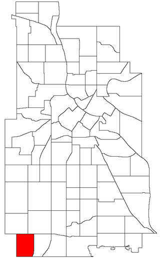
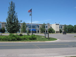
Armatage is a neighborhood in the Southwest community in Minneapolis. In the city's southwest corner, the neighborhood is bounded on the north by 54th Street West, on the east by Logan Avenue South, on the south by Highway 62, and on the west by the city limits at Xerxes Avenue South. Armatage is a part of Ward 13, currently represented by Minneapolis City Council member Linea Palmisano.

Bancroft is a neighborhood within the Powderhorn community in Minneapolis, Minnesota, United States. Its boundaries are East 38th Street to the north, Chicago Avenue to the west, East 42nd Street to the south and Cedar Avenue to the east. It is entirely located within Minneapolis City Council Ward 8, represented by Andrea Jenkins.
Bryant is a neighborhood within the Powderhorn community in Minneapolis, Minnesota, United States. Its boundaries are East 38th Street to the north, Chicago Avenue to the east, East 42nd Street to the south, and Interstate 35W to the west. It is entirely located within Minneapolis City Council Ward 8 represented by councilmember Andrea Jenkins, and Minnesota Senate District 62.

Powderhorn is a defined community in Minneapolis, that consists of eight neighborhoods. The greater Powderhorn community is named after Powderhorn Park.

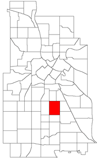
Corcoran is a neighborhood within the Powderhorn community in Minneapolis, Minnesota, United States. The neighborhood is bordered by Longfellow and Howe neighborhoods to the east, Phillips to the north, Powderhorn Park to the west and Standish to the south. Its official boundaries are East Lake Street to the north, Hiawatha Avenue to the east, East 36th Street to the south, and Cedar Avenue to the west. It is entirely located within Minneapolis City Council Ward 9, represented by Jason Chavez.
The Minneapolis Park and Recreation Board (MPRB) is an independent park district that owns, maintains, and programs activities in public parks in Minneapolis, Minnesota, United States. It has 500 full-time and 1,300 part-time employees and an $111 million operating and capital budget.

Little Earth Trail is an approximately 1-mile (1.6 km), multi-use bicycle path in Minneapolis, Minnesota, United States, that links several neighborhoods, parks, businesses, and trails in the Phillips community. The trail begins at its northern end near the intersection of East Franklin Avenue and 16th Avenue South and eventually follows the west side of Hiawatha Avenue to the Midtown Greenway and Martin Olav Sabo Bridge. Named after the nearby Little Earth community, the shared-use pathway provides transportation and recreation opportunities, and is a frequent location of activism on social justice issues in Minneapolis.

Minneapolis is often considered one of the top biking and walking cities in the United States due to its vast network of trails and dedicated pedestrian areas. In 2020, Walk Score rated Minneapolis as 13th highest among cities over 200,000 people. Some bicycling ratings list Minneapolis at the top of all United States cities, while others list Minneapolis in the top ten. There are over 80 miles (130 km) of paved, protected pathways in Minneapolis for use as transportation and recreation. The city's Grand Rounds National Scenic Byway parkway system accounts for the vast majority of the city's shared-use paths at approximately 50 miles (80 km) of dedicated biking and walking areas. By 2008, other city, county, and park board areas accounted for approximately 30 miles (48 km) of additional trails, for a city-wide total of approximately 80 miles (130 km) of protected pathways. The network of shared biking and walking paths continued to grow into the late 2010s with the additions of the Hiawatha LRT Trail gap remediation, Min Hi Line pilot projects, and Samatar Crossing. The city also features several natural-surface hiking trails, mountain-biking paths, groomed cross-country ski trails in winter, and other pedestrian walkways.

Samatar Crossing is a 1,850-foot (560 m), shared-use path and innovative urban redesign project in Minneapolis, Minnesota, United States. Posthumously named after Somali-American politician and activist Hussein Samatar, the crossing connects the Downtown East/Elliot Park and Cedar-Riverside neighborhoods via a former interstate highway ramp. The Samatar Crossing redevelopment project received national recognition when it opened in 2018.

As a reaction to the murder of George Floyd on May 25, 2020, racial justice activists and some residents of the Powderhorn community in Minneapolis staged an occupation protest at the intersection of East 38th Street and Chicago Avenue with a blockade of the streetway lasting over a year. The intersection is where Derek Chauvin, a white police officer with the Minneapolis Police Department, murdered George Floyd, an unarmed 46-year-old Black man. Activists erected barricades to block vehicular traffic and transformed the intersection and surrounding structures with amenities, social services, and public art depicting Floyd and other racial justice themes. The community called the unofficial memorial and protest zone at the intersection "George Floyd Square". The controversial street occupation in 2020 and 2021 was described as an "autonomous zone" and a "no-go" place for police, but local officials disputed the extent of such characterizations.
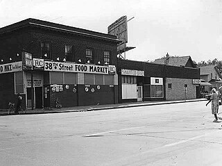
38th Street is a major east-west roadway in the U.S. city of Minneapolis and an officially designated cultural district in the Powderhorn community. The area developed into a residential zone when the Chicago Avenue street car line was extended to East 38th Street in 1880. Since the 1930s, the area has featured many Black-owned businesses, and the surrounding neighborhoods have had distinct histories from other neighborhoods in Minneapolis due to racial settlement patterns that concentrated Black residents there.
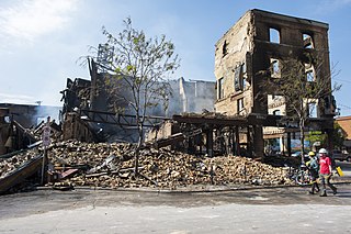
The aftermath of the George Floyd protests in Minneapolis–Saint Paul describes the result of civil disorder between May 26 and June 7, 2020, in the Twin Cities metropolitan area of the U.S. state of Minnesota. Protests began as a response to the murder of George Floyd, a 46-year-old African-American man on May 25, after Minneapolis police officer Derek Chauvin knelt on Floyd's neck for 9 minutes and 29 seconds as three other officers assisted during an arrest. The incident was captured on a bystander's video and it drew public outrage as video quickly circulated in the news media by the following day.

The U.S. city of Minneapolis featured officially and unofficially designated camp sites in city parks for people experiencing homelessness that operated from June 10, 2020, to January 7, 2021. The emergence of encampments on public property in Minneapolis was the result of pervasive homelessness, mitigations measures related to the COVID-19 pandemic in Minnesota, local unrest after the murder of George Floyd, and local policies that permitted encampments. At its peak in the summer of 2020, there were thousands of people camping at dozens of park sites across the city. Many of the encampment residents came from outside of Minneapolis to live in the parks. By the end of the permit experiment, four people had died in the city's park encampments, including the city's first homicide victim of 2021, who was stabbed to death inside a tent at Minnehaha Park on January 3, 2021.

Robin Wonsley is an American activist and politician affiliated with the Democratic Socialists of America who has been a member of the Minneapolis City Council from the 2nd Ward since 2021.

George Floyd Square, officially George Perry Floyd Square, is the commemorative street name for the section of 38th Street and Chicago Avenue in the U.S. city of Minneapolis from East 37th Street to East 39th Street. It is named after George Floyd, a black man who was murdered there by Minneapolis police officer Derek Chauvin on May 25, 2020. The streetway and memorial site is centered at the 38th and Chicago intersection.
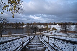
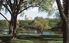
Powderhorn Park is an urban park in Minneapolis. It sits in the northwest of the Powderhorn Park neighborhood and near the center of the larger Powderhorn community, both of which take their names from the park. The park was established around Powderhorn Lake in the late 19th century.
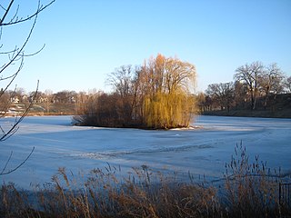
Powderhorn Lake is a small, natural lake within Powderhorn Park in Minneapolis, Minnesota, United States. The lake has a shoreline of 0.62 miles (1.00 km), a surface area of about 11 acres (0.045 km2), and a maximum depth of 24 feet (7.3 m). The lake is popular local destination for fishing and it is serves as a backdrop for many events and activities in Powderhorn Park. The lake takes its name from its original shape that more closely resembled a powder horn.