Seward is a neighborhood in the Longfellow community of Minneapolis, Minnesota, located geographically southeast of downtown. It consists of the land bordered by the Hiawatha Avenue industrial district to the west, Minneapolis Midtown Greenway to the south, the Mississippi River to the east, and Interstate 94 to the north.

The Central neighborhood of Minneapolis, Minnesota, United States is located south of the downtown region of the city. It is bounded by Lake Street on the north, Chicago Avenue on the east, 38th Street on the south, and Interstate 35W on the west. It should not be confused with the Central community, which covers Downtown and some surrounding neighborhoods.

The Powderhorn Park neighborhood of Minneapolis, Minnesota, United States is located approximately three miles south of downtown and is bordered by East Lake Street to the north, Cedar Avenue to the east, East 38th Street to the south, and Chicago Avenue to the west.

Howe is a neighborhood within the larger Longfellow community in Minneapolis. It is bordered by the Cooper and Longfellow neighborhoods to the north, Corcoran and Standish to the west, Hiawatha to the south, and the Mississippi River to the east. It is part of City Council Ward 12, represented by Aurin Chowdhury. The neighborhood and its elementary school are named for American writer and abolitionist Julia Ward Howe.

Field is a neighborhood in the Nokomis community in south Minneapolis, Minnesota. The neighborhood is bordered by East 46th Street on the north, Chicago Avenue on the east, Minnehaha Parkway on the south, and Interstate 35W on the west. Field shares a neighborhood organization with the Regina and Northrop neighborhoods, called the Field Regina Northrop Neighborhood Group (FRNNG).

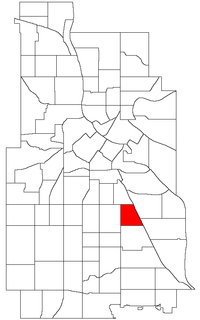
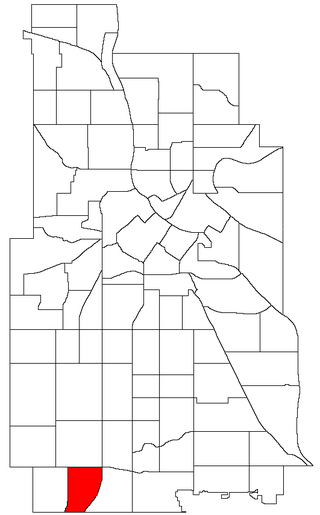
Bancroft is a neighborhood within the Powderhorn community in Minneapolis, Minnesota, United States. Its boundaries are East 38th Street to the north, Chicago Avenue to the west, East 42nd Street to the south and Cedar Avenue to the east. It is entirely located within Minneapolis City Council Ward 8, represented by Andrea Jenkins.

Downtown West is an official neighborhood in Minneapolis, part of the larger Central community. It is the heart of downtown Minneapolis, containing the bulk of high-rise office buildings in the city, and is what comes to mind when most Minneapolitans think of "downtown". The neighborhood is split between Wards 3 and 7 of the Minneapolis City Council, represented by Michael Rainville and Katie Cashman, respectively.
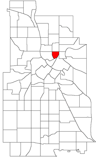
Phillips is a community in Minneapolis, just south of downtown. Traditionally, it was both a community and a neighborhood. Phillips is a diverse area in many ways: its population includes people of many nationalities; it has a mix of residential, commercial and industrial uses; and it is home to several large employers such as Abbott Northwestern Hospital, Wells Fargo Mortgage and Allina Health Care Services, along with small neighborhood businesses.

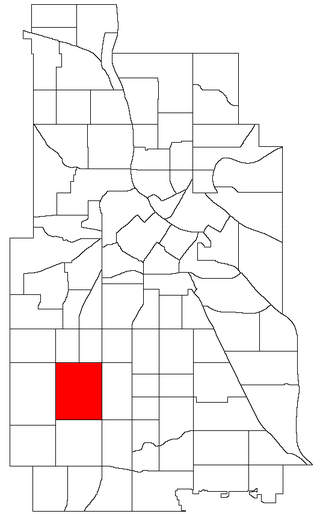
Lyndale is a neighborhood within the Powderhorn community in south Minneapolis, Minnesota, United States. Its boundaries are Lake Street to the north, Interstate 35W to the east, 36th Street to the south and Lyndale Avenue South to the west.
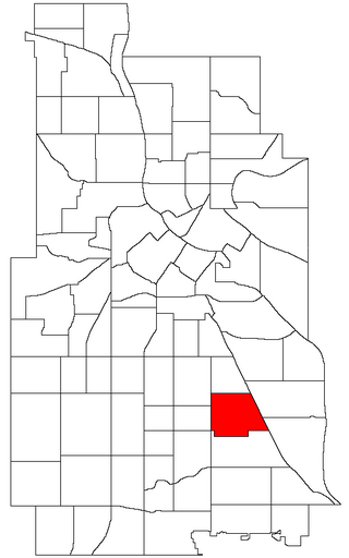
Standish is a neighborhood within the Powderhorn community in Minneapolis, Minnesota, United States named after Captain Miles Standish. Its boundaries are East 36th Street to the north, Hiawatha Avenue to the east, East 42nd and 43rd Streets to the south, and Cedar Avenue to the west.

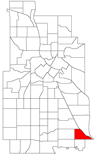
Ericsson is a neighborhood within the Nokomis community in Minneapolis. Its boundaries are East 42nd and 43rd Streets to the north, Hiawatha Avenue to the east, Minnehaha Parkway to the south, and Cedar Avenue to the west.
East Harriet is a neighborhood in the Southwest community in Minneapolis. Its boundaries are West 36th Street to the north, Lyndale Avenue South to the east, West 46th Street to the south, and Lake Harriet, Lakewood Cemetery, and William Berry Parkway to the west.
Kenny is a neighborhood in the Southwest community in Minneapolis. Its boundaries are West 54th Street to the north, Lyndale Avenue South and Highway 121 to the east, West 62nd Street to the south, and Logan Avenue South to the west. Kenny is a part of Ward 13, currently represented by Minneapolis City Council member Linea Palmisano.

Fulton is a neighborhood in the Southwest community in Minneapolis. Its boundaries are West 47th Street to the north, Penn Avenue South to the east, West 54th Street to the south, and France Avenue South to the west. Fulton is a part of Ward 13, currently represented by Minneapolis City Council member Linea Palmisano.

Regina is a neighborhood within the Nokomis community in Minneapolis, Minnesota. Its boundaries are 42nd Street to the north, Chicago Avenue to the east, 46th Street to the south, and Interstate 35W to the west.

Keewaydin is a neighborhood in the Nokomis community in Minneapolis, Minnesota. Its boundaries are Minnehaha Parkway to the north, 34th Avenue to the east, 54th Street to the south, and Cedar Avenue to the west.
Minnehaha is a neighborhood in the Nokomis community in Minneapolis, Minnesota. Its boundaries are Minnehaha Parkway to the north, Hiawatha Avenue to the east, 54th Street to the south, and 34th Avenue to the west. It is located in Ward 12 of the Minneapolis City Council, currently represented by council member Aurin Chowdhury.

Morris Park is a neighborhood in the Nokomis community in Minneapolis, Minnesota. Its boundaries are 54th Street to the north, 46th Avenue to the east, the Twin Cities Air Force Base to the south, and 34th Avenue to the west. It is located in Ward 12 of the Minneapolis City Council, currently represented by council member Aurin Chowdhury.
St. Anthony East is a neighborhood of the Northeast community in Minneapolis. It is located in Ward 3, currently represented by council member Michael Rainville.

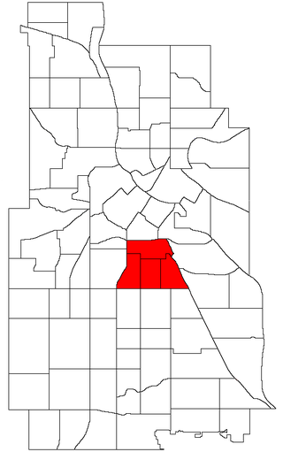
Powderhorn is a defined community in Minneapolis, that consists of eight neighborhoods. The greater Powderhorn community is named after Powderhorn Park.