Elliot Park, Minneapolis

Last updated
Elliot Park
MinneapolisElliotParkNeighborhood.PNG
Location of Elliot Park within the U.S. city of Minneapolis
Coordinates: 44°58′10″N93°15′45″W / 44.96944°N 93.26250°W / 44.96944; -93.26250
Country United States
State Minnesota
County Hennepin
City Minneapolis
Community Central
Founded1849
City Council Ward6
Government
  Council Member Jamal Osman
Area
[1]
  Total0.404 sq mi (1.05 km2)
Population
 (2020) [2]
  Total7,509
  Density19,000/sq mi (7,200/km2)
Time zone UTC-6 (CST)
  Summer (DST) UTC-5 (CDT)
ZIP code
55404, 55415
Area code 612
Historical population
CensusPop.Note
1980 5,287
1990 5,6787.4%
2000 6,47614.1%
2010 6,6933.4%
2020 7,50912.2%
Elliot Park, at the center of the neighborhood of the same name 051907-001-ElliotPark.jpg
Elliot Park, at the center of the neighborhood of the same name
Jones Memorial Library, the prominent building of North Central University, faces Elliot Park. 051907-002-NorthCentralU.jpg
Jones Memorial Library, the prominent building of North Central University, faces Elliot Park.

Elliot Park is a neighborhood within the larger Central community in Minneapolis. It is part of Ward 6 of the Minneapolis City Council, [3] represented by Jamal Osman.

Contents

Location and Characteristics

Elliot Park is bordered on the north by the Downtown West and Downtown East neighborhoods, on the west by Loring Park, on the east by Cedar-Riverside, and on the south by Phillips. Its official boundaries are 5th Avenue South to the northwest, 5th Street South to the northeast, Highway 55 to the east, the Interstate 94/Interstate 35W commons to the south, and 4th Avenue South to the west.

The neighborhood occupies both the Downtown Minneapolis street grid (running parallel to the Mississippi River) and the South Minneapolis street grid (running north–south and east–west), creating many triangular street corners where the two grids meet. It is mostly part of Ward 6 of the Minneapolis City Council, [4] ; the only exception is one non-residential block in the northernmost corner of the neighborhood, which is in Ward 3.

It was the home of some of Minneapolis's wealthiest citizens in Minneapolis's early years. As the city grew and encompassed the neighborhood, most of the wealthy citizens left to build in more secluded neighborhoods like Lowry Hill and Kenwood. A few historic mansions and buildings from Minneapolis's early years can be found in some parts of Elliot Park. [5]

History

Elliot Park is one of Minneapolis's oldest neighborhoods, with plots set for housing as early as 1856. It was close to industrial developments on the nearby banks of the Mississippi River, which made it a popular settlement for early Swedish immigrants.

The namesake for the neighborhood is Mr. Joseph Elliot, an area physician, who donated his farm land to the city in 1893. This land is the site of the current Elliot Park, and another generous donation of Mr. Elliot resulted in the founding of Steele Park - these were the city's first two parks.

It began to rise to wealth near the end of the 19th century, as Downtown Minneapolis began to experience rapid growth. The neighborhood at that time had the city's only two parks, which made it a fashionable area to live in. Several large mansions sprang up along Park Avenue.

During the next twenty years, as the city began to grow more and more quickly, the character of the neighborhood began to change. The need for higher concentrations of people transformed the neighborhood into an area of three and four storey brick apartment buildings. Of these, the Rappahannock Condominiums are among the oldest in the city. Included are boston-esque brownstone buildings that connect Elliot Park to the core of downtown Minneapolis.

The area began to decline in wealth in the mid-20th century, as the high housing density attracted lower income families. The construction of the interstate system resulted in large areas of the city being gutted, and between 1950 and 1970 the population declined by almost 54%. The freeway construction also resulted in the relocation of several area businesses, which changed the character of the commercial sector, and resulted in a much higher transient population.

The neighborhood's historical contribution to Minneapolis remains significant. Two of the neighborhood's buildings are on the National Register of Historic Places: The First Church of Christ, Scientist on 15th Street and the Hinkle-Murphy House at 619 S 10th Street. The neighborhood has been home to North Central University since 1936.

By the turn of the century, the neighborhood has begun to quickly gentrify, with numerous, high priced luxury condos enriching the neighborhood's borders with the Central and Downtown East neighborhoods. The additions of Grant Park and the Skyscape condominiums have created a sudden increase in the young professional population in Elliot Park and has increased the appeal of Elliot Park as a downtown hot-spot for professionals seeking a cosmopolitan lifestyle. These additions, combined with the expansion of the Hennepin County Medical Center, have increased the attention on Elliot Park as a neighborhood undergoing significant redevelopment and gentrification.

Notable residents

Related Research Articles

<span class="mw-page-title-main">Seward, Minneapolis</span> Neighborhood of Minneapolis

The Seward neighborhood in Minneapolis, Minnesota, United States, is a neighborhood in the Longfellow community of Minneapolis located geographically southeast of downtown. It consists of the land bordered by the Hiawatha Avenue industrial district to the west, Minneapolis Midtown Greenway to the south, the Mississippi River to the east, and Interstate 94 to the north.

<span class="mw-page-title-main">North Loop, Minneapolis</span> Neighborhood in Hennepin, Minnesota, United States

The North Loop is a neighborhood in the Central community of Minneapolis.

<span class="mw-page-title-main">Whittier, Minneapolis</span> Neighborhood in Hennepin, Minnesota, United States

Whittier is a neighborhood within the Powderhorn community in the U.S. city of Minneapolis, Minnesota, bounded by Franklin Avenue on the north, Interstate 35W on the east, Lake Street on the south, and Lyndale Avenue on the west. It is known for its many diverse restaurants, coffee shops and Asian markets, especially along Nicollet Avenue. The neighborhood is home to the Minneapolis Institute of Art, the Minneapolis College of Art and Design, and the Children's Theatre Company.

<span class="mw-page-title-main">Neighborhoods of Minneapolis</span> Official communities and neighborhood of Minneapolis

Minneapolis is officially defined by its city council as divided into 83 neighborhoods. The neighborhoods are historically grouped into 11 communities. Informally, there are city areas with colloquial labels. Residents may also group themselves by their city street suffixes, North, Northeast, South, Southeast, and Southwest.

<span class="mw-page-title-main">Lake Street (Minneapolis)</span>

Lake Street is a major east-west thoroughfare between 29th and 31st streets in Minneapolis, Minnesota United States. From its western most end at the city's limits, Lake Street reaches the Chain of Lakes, passing over a small channel linking Bde Maka Ska and Lake of the Isles, and at its eastern most end it reaches the Mississippi River. In May 2020, the Lake Street corridor suffered extensive damage during local unrest following the murder of George Floyd. In August of the same year, city officials designated East Lake Street as one of seven cultural districts to promote racial equity, preserve cultural identity, and promote economic growth.

<span class="mw-page-title-main">Loring Park, Minneapolis</span> Neighborhood in Minneapolis, Minnesota, United States

Loring Park is a neighborhood in the Central Community of Minneapolis, Minnesota. Located on the southwest corner of downtown Minneapolis, it also lends its name to Loring Park, the largest park in the neighborhood. The official boundaries of the neighborhood are Lyndale Avenue to the west, Interstate 394 to the north, 12th Street to the northeast, Highway 65 to the east, and Interstate 94 to the south. It is located in Minneapolis City Council Ward 7, represented by Katie Cashman.

<span class="mw-page-title-main">Bancroft, Minneapolis</span> Neighborhood of Minneapolis

Bancroft is a neighborhood within the Powderhorn community in Minneapolis, Minnesota, United States. Its boundaries are East 38th Street to the north, Chicago Avenue to the west, East 42nd Street to the south and Cedar Avenue to the east. It is entirely located within Minneapolis City Council Ward 8, represented by Andrea Jenkins.

<span class="mw-page-title-main">Central, Minneapolis</span> Community of Minneapolis

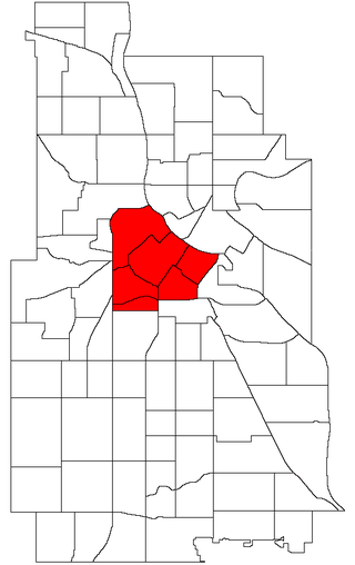
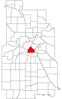
Central is a defined community in Minneapolis that consists of six smaller official neighborhoods around the downtown and central business core. It also includes the many old flour mills, the Mill District, and other historical and industrial areas of downtown Minneapolis. It also includes some high-density residential areas surrounding it, excluding areas east of the Mississippi River. Businesses and government buildings are based in the Central area include the corporate headquarters of the Star Tribune, Target, US Bancorp, the Hennepin County Government Center, Minneapolis Central Library, Minneapolis City Hall, and the broadcast facilities of the Minnesota CBS station WCCO-TV.

<span class="mw-page-title-main">Longfellow, Minneapolis</span> Community of Minneapolis

Longfellow, also referred to as Greater Longfellow is a defined community in Minneapolis, Minnesota which includes five smaller neighborhoods inside of it: Seward, Cooper, Hiawatha, Howe and Longfellow. The community is a mix of agri-industrial properties along the old Northern Pacific Railway, expansive parkland surrounding the famous Minnehaha Falls, and smaller residential areas.

<span class="mw-page-title-main">Stevens Square, Minneapolis</span> Neighborhoods of Minneapolis in Hennepin, Minnesota, United States

Stevens Square is the southernmost neighborhood of the Central community in Minneapolis. It is bordered on Lyndale Avenue on the west, Franklin Avenue on the south, and Interstates 94 and 35W on the north and east, respectively. The portion west of Nicollet Avenue can be referred to as Loring Heights; the portion to the East as Stevens Square.

<span class="mw-page-title-main">Downtown West, Minneapolis</span> Neighborhood in Hennepin, Minnesota, United States

Downtown West is an official neighborhood in Minneapolis, part of the larger Central community. It is the heart of downtown Minneapolis, containing the bulk of high-rise office buildings in the city, and is what comes to mind when most Minneapolitans think of "downtown". The neighborhood is split between Wards 3 and 7 of the Minneapolis City Council, represented by Michael Rainville and Katie Cashman, respectively.

<span class="mw-page-title-main">Downtown East, Minneapolis</span> Neighborhood in Hennepin, Minnesota, United States

Downtown East is an official neighborhood in Minneapolis, Minnesota, United States. It is in Ward 3, currently represented by council member Michael Rainville.

<span class="mw-page-title-main">Phillips, Minneapolis</span> Community of Minneapolis

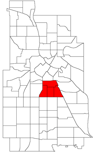
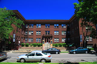
Phillips is a community in Minneapolis, just south of downtown. Traditionally, it was both a community and a neighborhood. Phillips is a diverse area in many ways: its population includes people of many nationalities; it has a mix of residential, commercial and industrial uses; and it is home to several large employers such as Abbott Northwestern Hospital, Wells Fargo Mortgage and Allina Health Care Services, along with small neighborhood businesses.

<span class="mw-page-title-main">Bottineau, Minneapolis</span> Neighborhood in Hennepin, Minnesota, United States

Bottineau is a neighborhood in the Northeast community of Minneapolis. It is one of ten neighborhoods in Ward 1 of Minneapolis, currently represented by Council President Elliott Payne.

<span class="mw-page-title-main">Sumner-Glenwood, Minneapolis</span> Neighborhood in Hennepin, Minnesota, United States

Sumner-Glenwood is a neighborhood in the Near North community of Minneapolis. The neighborhood is roughly contained by 15 city blocks bordered to the north by 11th Avenue North, to the south by Glenwood Avenue, to the east by Interstate 94, and to the west by both Girard Terrace and Emerson Avenue North. It is located in Ward 5, represented by city council member Jeremiah Ellison. The neighborhood includes the Heritage Park mixed-use area.

<span class="mw-page-title-main">Mill District, Minneapolis</span> Neighborhood in Minneapolis, Minnesota, United States

The Mill District is a neighborhood within Minneapolis, Minnesota, United States, and a part of the larger Downtown East neighborhood. The neighborhood contains several former flour mills left over from the days when Minneapolis was the flour milling capital of the world. With almost none of the mills still active, a number of these have been converted into condominiums leading to a revitalization of the neighborhood.

<span class="mw-page-title-main">King Field, Minneapolis</span> Neighborhood in Hennepin, Minnesota, United States

King Field is a neighborhood in the Southwest community in Minneapolis, Minnesota. Its boundaries are 36th Street to the north, Interstate 35W to the east, 46th Street to the south, and Lyndale Avenue to the west. King Field, within the King Field neighborhood is a park named after Martin Luther King Jr.

<span class="mw-page-title-main">Neighborhoods in Saint Paul, Minnesota</span> Communities and neighborhoods in Saint Paul, Minnesota

Saint Paul, Minnesota, consists of 17 officially defined city districts or neighborhoods.

<span class="mw-page-title-main">Samatar Crossing</span> Shared-use path in Minneapolis

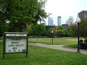
Samatar Crossing is a 1,850-foot (560 m), shared-use path and innovative urban redesign project in Minneapolis, Minnesota, United States. Posthumously named after Somali-American politician and activist Hussein Samatar, the crossing connects the Downtown East/Elliot Park and Cedar-Riverside neighborhoods via a former interstate highway ramp. The Samatar Crossing redevelopment project received national recognition when it opened in 2018.

<span class="mw-page-title-main">Downtown Milwaukee</span> Area of Milwaukee, Wisconsin, United States

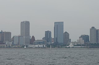
Downtown Milwaukee is the central business district of Milwaukee, Wisconsin. The economic and symbolic center of the city and the Milwaukee metropolitan area, it is Milwaukee's oldest district and home to many of region's cultural, financial educational and historical landmarks including Milwaukee City Hall, Fiserv Forum and the Milwaukee Art Museum. The city's modern history began in Downtown Milwaukee in 1795 when fur trader Jacques Vieau (1757–1852) built a post along a bluff on the east side, overlooking the Milwaukee and Menomonee rivers.

References

  1. "Elliot Park neighborhood in Minneapolis, Minnesota (MN), 55404, 55415 detailed profile". City-Data. 2011. Retrieved 2013-11-12.
  2. "Elliot Park neighborhood data". Minnesota Compass. Retrieved 2023-02-19.
  3. "Find My Ward". City of Minneapolis. Retrieved 19 April 2024.
  4. "Find My Ward". City of Minneapolis. Retrieved 19 April 2024.
  5. "Elliot Park". Minneapolis Park & Recreation Board. Retrieved 2021-11-11.
  6. http://www.citypages.com/news/sorry-charlie-6707579
  7. "The Heritage Affordable Homes - Aeon". Archived from the original on 2017-03-02. Retrieved 2017-03-02.