
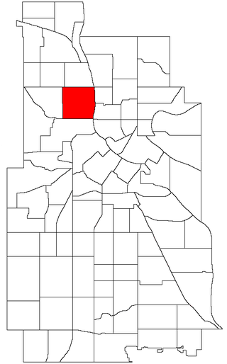
The Central neighborhood of Minneapolis, Minnesota, United States is located south of the downtown region of the city. It is bounded by Lake Street on the north, Chicago Avenue on the east, 38th Street on the south, and Interstate 35W on the west. It should not be confused with the Central community, which covers Downtown and some surrounding neighborhoods.
Arthur Naftalin was an American political scientist and politician. A member of the Minnesota Democratic-Farmer-Labor Party (DFL), he served as mayor of Minneapolis from July 3, 1961, to July 6, 1969. He was the first Jewish mayor of Minneapolis.

Minneapolis is officially defined by its city council as divided into 83 neighborhoods. The neighborhoods are historically grouped into 11 communities. Informally, there are city areas with colloquial labels. Residents may also group themselves by their city street suffixes, North, Northeast, South, Southeast, and Southwest.

Loring Park is a neighborhood in the Central Community of Minneapolis, Minnesota. Located on the southwest corner of downtown Minneapolis, it also lends its name to Loring Park, the largest park in the neighborhood. The official boundaries of the neighborhood are Lyndale Avenue to the west, Interstate 394 to the north, 12th Street to the northeast, Highway 65 to the east, and Interstate 94 to the south. It is located in Minneapolis City Council Ward 7, represented by Katie Cashman.
Stevens Square is the southernmost neighborhood of the Central community in Minneapolis. It is bordered on Lyndale Avenue on the west, Franklin Avenue on the south, and Interstates 94 and 35W on the north and east, respectively. The portion west of Nicollet Avenue can be referred to as Loring Heights; the portion to the East as Stevens Square.
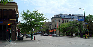
Northeast is a defined community in the U.S. city of Minneapolis that is composed of 13 smaller neighborhoods whose street addresses end in "NE". Unofficially it also includes the neighborhoods of the University community which have "NE" addresses, and the entirety of the Old Saint Anthony business district, which sits on the dividing line of "NE" and "SE" addresses. In the wider community, this business district, which is the oldest settlement in the city, is often identified as the heart of Northeast, in part because it lies across the Mississippi River from Downtown Minneapolis. Northeast is sometimes referred to as "Nordeast", reflecting the history of northern and eastern European immigrants and their language influence.

Camden is a community in Minneapolis, covering the upper half of the north side. Its boundaries are 53rd Avenue North to the north, the Mississippi River to the east, Lowry Avenue North to the south, and Xerxes Avenue North to the west. It is located in Ward 4 of the Minneapolis City Council, represented by council member LaTrisha Vetaw.

Near North is one of six neighborhoods in the Near North community of Minneapolis. It is located in Ward 5, represented by city council member Jeremiah Ellison.

Cleveland is a neighborhood in the Camden community in Minneapolis. It is located in Ward 4, represented by council member LaTrisha Vetaw. Its boundaries are Dowling Avenue to the north, Penn Avenue North to the east, Lowry Avenue north to the south, and Xerxes Avenue North to the west. To the west of Xerxes Avenue is the suburb of Robbinsdale.

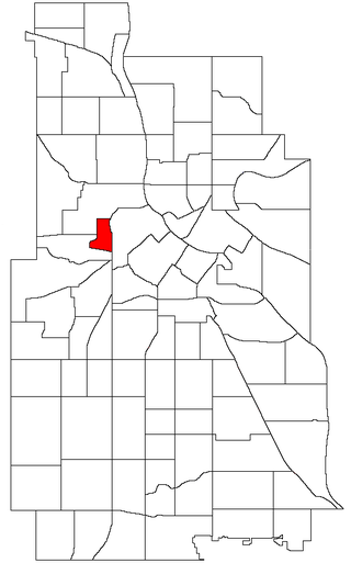
Harrison is a neighborhood in the Near North community in the U.S. city of Minneapolis, located to the west of downtown. Its boundaries are roughly, Olson Memorial Highway to the north, Lyndale Avenue to the east, Bassetts Creek to the south, and Theodore Wirth Park to the west. It is located in Ward 5, represented by city council member Jeremiah Ellison.
Hawthorne is a neighborhood in the Near North community in Minneapolis. Its boundaries are Lowry Avenue North to the north, the Mississippi River to the east, West Broadway to the south, and Emerson Avenue North to the west. It is located in Ward 5, represented by city council member Jeremiah Ellison. The neighborhood is named in honor of 19th Century American author Nathaniel Hawthorne.
Sumner-Glenwood is a neighborhood in the Near North community of Minneapolis. The neighborhood is roughly contained by 15 city blocks bordered to the north by 11th Avenue North, to the south by Glenwood Avenue, to the east by Interstate 94, and to the west by both Girard Terrace and Emerson Avenue North. It is located in Ward 5, represented by city council member Jeremiah Ellison. The neighborhood includes the Heritage Park mixed-use area.

William Harry Davis, Sr. was an American civil rights activist, amateur boxing coach, civic leader, and businessman in Minneapolis, Minnesota. He overcame poverty, childhood polio, and racial prejudice to become a humanitarian. Davis is remembered for his warm and positive personality, for coaching Golden Gloves champions in the upper Midwest, and for managing the Olympics boxing team that won nine gold medals. His contributions to public education in his community are enduring. A leader in desegregation during the Civil Rights Movement, Davis helped Americans find a way forward to racial equality.

Willard-Hay is a neighborhood within the larger Near North community in the northwest side of the U.S. city of Minneapolis which is known locally as the "Northside". The neighborhood is often known as Willard-Homewood by residents; the portion south of Plymouth is Homewood. It is named after two elementary schools within its boundaries, Frances Willard and John Hay.

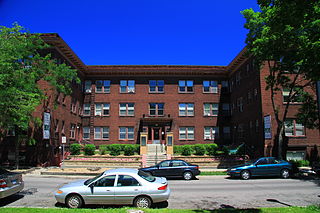
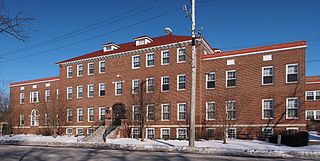
Sumner Library is a neighborhood library located in the Near-north neighborhood of Minneapolis, Minnesota, United States. Originally part of the Minneapolis Public Library, it became part of the merged Hennepin County Library in 2008. The Carnegie Library was a haven for Jewish immigrants to the city in the early 20th century. The Minneapolis Public Library moved its entire collection of Yiddish and Hebrew works to the branch library in response to a survey showing that 95% of the patrons were Jewish immigrants, some of whom learned English there and participated in social clubs in the building. The Tudor Revival building is listed on the National Register of Historic Places.
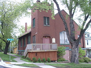
North East Neighborhood House (NENH) is a building in the Northeast neighborhood of Minneapolis, Minnesota. The building housed a social services organization established in 1915 by Plymouth Church, a Minneapolis congregational church. The roots of the organization go back to Immanuel Sunday School, established in 1881 near Second Street Northeast and Broadway Street Northeast. The school later built a new building, Drummond Hall, near Second Street Northeast and 15th Avenue Northeast. The church expanded its programs to include various social services and clubs for neighborhood residents who had immigrated to Northeast Minneapolis from France, Germany, and Scandinavia. The demographics of the area had changed by the 1910s, though, and most of the newcomers were from eastern Europe. These newcomers still needed social services, but since most of them were Catholic, they were unwilling to accept Protestant religious education. The attendance dropped, forcing Drummond Hall to close in 1913.
St. Mark's African Methodist Episcopal Church is a historic African Methodist Episcopal (AME) church in Duluth, Minnesota, United States. St. Mark's has played a central role in Duluth's African-American community for more than 124 years. While other black organizations have dissolved or moved to the Minneapolis–Saint Paul area, St. Mark's has been a local mainstay.
The 1967 Minneapolis riot was one of the 159 riots that swept across cities in the United States during the "long, hot summer of 1967".
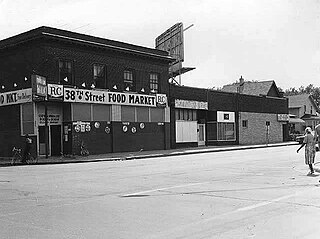
38th Street is a major east-west roadway in the U.S. city of Minneapolis and an officially designated cultural district in the Powderhorn community. The area developed into a residential zone when the Chicago Avenue street car line was extended to East 38th Street in 1880. Since the 1930s, the area has featured many Black-owned businesses, and the surrounding neighborhoods have had distinct histories from other neighborhoods in Minneapolis due to racial settlement patterns that concentrated Black residents there.
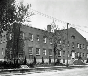
The Phyllis Wheatley Settlement House in Minneapolis, Minnesota was founded in 1924 by the Council on Social Agencies (CSA) and the Women's Cooperative Alliance (WCA). Its original function was to provide a recreational facility that could be used by the Minneapolis African American community.
